289:
219:
233:
257:
295:
300:
67:
933:
121:
Former
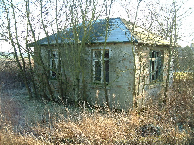
Stravithie airfield watch office. This dilapidated building (and a tractor shed next to it) are all that is left to mark where, from 1941 till 1945, a RAF satellite landing ground was in use. Hurricanes, Wellingtons and even four-engine bombers like Halifaxes once landed and took off from the
210:
38:
950:== {{int:filedesc}} == {{Information |description={{en|1=Former Stravithie airfield watch office. This dilapidated building (and a tractor shed next to it) are all that is left to mark where, from 1941 till 1945, a RAF satellite landing ground was in use.
78:
46:
347:– You must give appropriate credit, provide a link to the license, and indicate if changes were made. You may do so in any reasonable manner, but not in any way that suggests the licensor endorses you or your use.
964:
932:
927:
37:
739:
618:
582:
546:
226:
653:
427:
1102:
264:
975:
This file contains additional information, probably added from the digital camera or scanner used to create or digitize it.
354:
496:
861:
827:
793:
759:
723:
661:
602:
530:
504:
489:
474:
689:
646:
631:
566:
447:
411:
251:
310:
1071:
978:
If the file has been modified from its original state, some details may not fully reflect the modified file.
1147:
353:– If you remix, transform, or build upon the material, you must distribute your contributions under the
271:
on the
Geograph website for the photographer's contact details. The copyright on this image is owned by
943:
997:
307:
1175:
86:
179:
668:
638:
481:
163:
232:
1237:
1165:
1121:
276:
73:
1034:
1185:
131:
1014:
216:
152:
142:
1227:
1004:
987:
256:
111:
Former
Stravithie airfield watch office - geograph.org.uk - 115002.jpg
47:
Former_Stravithie_airfield_watch_office_-_geograph.org.uk_-_115002.jpg
268:
900:
Click on a date/time to view the file as it appeared at that time.
218:
122:
relatively small field behind and to the left of this building.
201:
61:
752:
211:
56° 18′ 05″ N, 2° 45′ 07″ W
395:
Add a one-line explanation of what this file represents
105:
85:
Commons is a freely licensed media file repository.
583:
Creative
Commons Attribution-ShareAlike 2.0 Generic
965:List of Royal Air Force Satellite Landing Grounds
51:(640 × 480 pixels, file size: 162 KB, MIME type:
364:https://creativecommons.org/licenses/by-sa/2.0
66:
370:Creative Commons Attribution-Share Alike 2.0
288:
8:
330:– to copy, distribute and transmit the work
980:
902:
391:
639:https://www.geograph.org.uk/photo/115002
482:https://www.geograph.org.uk/profile/4202
1235:
1225:
1217:
1209:
1201:
1193:
1183:
1173:
1163:
1155:
1145:
1137:
1129:
1119:
1111:
1100:
1092:
1084:
1076:
1066:
1058:
1050:
1042:
1031:
1023:
1012:
1002:
992:
962:
875:
859:
841:
825:
807:
791:
773:
757:
737:
721:
703:
687:
616:
600:
580:
564:
544:
528:
461:
445:
425:
409:
406:
387:
380:
204:
194:Former Stravithie airfield watch office
175:Former Stravithie airfield watch office
225:View this and other nearby images on:
982:
7:
275:and is licensed for reuse under the
960:The following page uses this file:
891:
311:Attribution-Share Alike 2.0 Generic
299:
294:
279:Attribution-ShareAlike 2.0 license.
973:
400:
394:
285:
262:
115:
98:
44:
399:
1025:Date and time of data generation
385:
341:Under the following conditions:
306:This file is licensed under the
298:
293:
287:
255:
231:
217:
65:
21:
382:
116:
41:No higher resolution available.
14:
619:file available on the internet
381:
263:This image was taken from the
26:
1:
760:coordinates of depicted place
31:
654:Geograph Britain and Ireland
490:object of statement has role
407:Items portrayed in this file
1211:Focal plane resolution unit
1113:Date and time of digitizing
1259:
1222:One-chip color area sensor
355:same or compatible license
1078:File change date and time
892:
16:
1203:Focal plane Y resolution
1195:Focal plane X resolution
662:geograph.org.uk image ID
384:
321:
192:James Allan /
173:James Allan /
72:This is a file from the
949:
775:56°18'4.7"N, 2°45'7.2"W
164:required by the license
148:
137:
130:
127:
108:
76:. Information from its
1116:13:09, 30 January 2006
1081:16:12, 30 January 2006
1072:FinePix Viewer Ver.2.0
1028:13:09, 30 January 2006
928:09:49, 31 January 2010
269:this photograph's page
237:56.301300; -2.752000
79:description page there
1157:Maximum land aperture
1052:Horizontal resolution
724:location of creation
1086:Y and C positioning
1060:Vertical resolution
984:Camera manufacturer
336:– to adapt the work
1242:Auto white balance
1180:Flash did not fire
505:author name string
1246:
1245:
953:
567:copyright license
393:
284:
283:
267:collection. See
242:
241:
199:
198:
167:
94:
93:
74:Wikimedia Commons
1250:
1094:Exposure Program
981:
940:
880:
671:
666:
656:
651:
641:
636:
632:described at URL
531:copyright status
512:
509:
499:
494:
484:
479:
377:
374:
371:
368:
365:
357:as the original.
319:
308:Creative Commons
302:
301:
297:
296:
291:
290:
277:Creative Commons
265:Geograph project
259:
252:
238:
235:
221:
220:
214:
213:
202:
161:
133:
120:
112:
106:
90:
69:
68:
62:
56:
54:
1258:
1257:
1253:
1252:
1251:
1249:
1248:
1247:
1160:3 APEX (f/2.83)
1139:APEX brightness
998:FinePix6900ZOOM
969:
954:
946:
938:
894:
893:
890:
889:
888:
887:
886:
885:
884:
883:
881:
878:
868:
867:
866:
864:
853:
852:
851:
850:
849:
848:
847:
846:
844:
834:
833:
832:
830:
819:
818:
817:
816:
815:
814:
813:
812:
810:
800:
799:
798:
796:
785:
784:
783:
782:
781:
780:
779:
778:
776:
766:
765:
764:
762:
751:
750:
749:
748:
747:
746:
745:
744:
742:
730:
729:
728:
726:
715:
714:
713:
712:
711:
710:
709:
708:
706:
705:30 January 2006
696:
695:
694:
692:
681:
680:
679:
678:
677:
676:
675:
674:
673:
672:
667:
664:
658:
657:
652:
649:
643:
642:
637:
634:
625:
624:
623:
621:
609:
608:
607:
605:
594:
593:
592:
591:
590:
589:
588:
587:
585:
573:
572:
571:
569:
558:
557:
556:
555:
554:
553:
552:
551:
549:
537:
536:
535:
533:
522:
521:
520:
519:
518:
517:
516:
515:
514:
513:
510:
507:
501:
500:
495:
492:
486:
485:
480:
477:
468:
467:
466:
464:
454:
453:
452:
450:
439:
438:
437:
436:
435:
434:
433:
432:
430:
418:
417:
416:
414:
398:
397:
396:
379:
378:
375:
372:
369:
366:
363:
362:
320:
317:
314:
303:
280:
250:
236:
209:
208:
205:Object location
200:
189:
182:
170:
143:geograph.org.uk
132:30 January 2006
123:
110:
103:
96:
95:
84:
83:
82:is shown below.
58:
52:
50:
43:
42:
12:
11:
5:
1256:
1254:
1244:
1243:
1240:
1234:
1233:
1230:
1224:
1223:
1220:
1219:Sensing method
1216:
1215:
1212:
1208:
1207:
1204:
1200:
1199:
1196:
1192:
1191:
1188:
1182:
1181:
1178:
1172:
1171:
1168:
1162:
1161:
1158:
1154:
1153:
1150:
1144:
1143:
1140:
1136:
1135:
1132:
1128:
1127:
1124:
1118:
1117:
1114:
1110:
1109:
1106:
1099:
1098:
1097:Normal program
1095:
1091:
1090:
1087:
1083:
1082:
1079:
1075:
1074:
1069:
1065:
1064:
1061:
1057:
1056:
1053:
1049:
1048:
1045:
1041:
1040:
1037:
1030:
1029:
1026:
1022:
1021:
1018:
1011:
1010:
1007:
1001:
1000:
995:
991:
990:
985:
972:
968:
967:
958:
957:
952:
951:
948:
944:
941:
935:
930:
925:
921:
920:
917:
914:
911:
908:
905:
898:
897:
882:
876:
874:
873:
872:
871:
870:
869:
865:
860:
858:
857:
856:
855:
854:
845:
842:
840:
839:
838:
837:
836:
835:
831:
826:
824:
823:
822:
821:
820:
811:
808:
806:
805:
804:
803:
802:
801:
797:
792:
790:
789:
788:
787:
786:
777:
774:
772:
771:
770:
769:
768:
767:
763:
758:
756:
755:
754:
753:
743:
738:
736:
735:
734:
733:
732:
731:
727:
722:
720:
719:
718:
717:
716:
707:
704:
702:
701:
700:
699:
698:
697:
693:
688:
686:
685:
684:
683:
682:
660:
659:
645:
644:
630:
629:
628:
627:
626:
622:
617:
615:
614:
613:
612:
611:
610:
606:
603:source of file
601:
599:
598:
597:
596:
595:
586:
581:
579:
578:
577:
576:
575:
574:
570:
565:
563:
562:
561:
560:
559:
550:
545:
543:
542:
541:
540:
539:
538:
534:
529:
527:
526:
525:
524:
523:
503:
502:
488:
487:
473:
472:
471:
470:
469:
465:
462:
460:
459:
458:
457:
456:
455:
451:
446:
444:
443:
442:
441:
440:
431:
426:
424:
423:
422:
421:
420:
419:
415:
410:
408:
405:
404:
403:
402:
401:
390:
389:
386:
383:
361:
360:
359:
358:
348:
339:
338:
337:
331:
324:You are free:
315:
305:
304:
286:
282:
281:
260:
249:
246:
240:
239:
229:
223:
206:
197:
196:
190:
187:
184:
183:
178:
171:
168:
156:
155:
150:
146:
145:
139:
135:
134:
129:
125:
124:
113:
104:
102:
99:
97:
92:
91:
70:
60:
59:
40:
36:
35:
34:
29:
24:
19:
13:
10:
9:
6:
4:
3:
2:
1255:
1241:
1239:
1238:White balance
1236:
1231:
1229:
1226:
1221:
1218:
1213:
1210:
1205:
1202:
1197:
1194:
1189:
1187:
1184:
1179:
1177:
1174:
1169:
1167:
1166:Metering mode
1164:
1159:
1156:
1151:
1149:
1148:Exposure bias
1146:
1141:
1138:
1133:
1131:APEX aperture
1130:
1125:
1123:
1122:Shutter speed
1120:
1115:
1112:
1107:
1104:
1101:
1096:
1093:
1088:
1085:
1080:
1077:
1073:
1070:
1068:Software used
1067:
1062:
1059:
1054:
1051:
1046:
1043:
1038:
1036:
1032:
1027:
1024:
1019:
1016:
1013:
1008:
1006:
1003:
999:
996:
993:
989:
986:
983:
979:
976:
970:
966:
963:
961:
955:
947:
942:
936:
934:
931:
929:
926:
923:
922:
918:
915:
912:
909:
906:
904:
903:
901:
895:
863:
829:
795:
761:
741:
725:
691:
670:
663:
655:
648:
640:
633:
620:
604:
584:
568:
548:
532:
506:
498:
491:
483:
476:
449:
429:
413:
367:CC BY-SA 2.0
356:
352:
349:
346:
343:
342:
340:
335:
332:
329:
326:
325:
323:
322:
316:Attribution:
312:
309:
292:
278:
274:
270:
266:
261:
258:
254:
253:
247:
245:
244:
234:
230:
228:
227:OpenStreetMap
224:
222:
212:
207:
203:
195:
191:
186:
185:
181:
177: /
176:
172:
165:
160:
158:
157:
154:
151:
147:
144:
140:
136:
126:
119:
114:
107:
100:
88:
81:
80:
75:
71:
64:
63:
57:
48:
39:
33:
30:
28:
25:
23:
20:
18:
15:
1035:focal length
994:Camera model
977:
974:
959:
899:
896:File history
862:focal length
497:photographer
350:
344:
333:
327:
272:
243:
193:
180:CC BY-SA 2.0
174:
117:
87:You can help
77:
45:
22:File history
1186:Color space
1044:Orientation
945:GeographBot
547:copyrighted
511:James Allan
351:share alike
345:attribution
318:James Allan
273:James Allan
159:Attribution
153:James Allan
109:Description
956:File usage
937:640 × 480
913:Dimensions
879:millimetre
463:some value
53:image/jpeg
27:File usage
1228:Sharpness
1015:ISO speed
910:Thumbnail
907:Date/Time
794:ISO speed
690:inception
248:Licensing
188:InfoField
169:InfoField
118:English:
1089:Co-sited
1005:F-number
988:FUJIFILM
971:Metadata
939:(162 KB)
828:f-number
647:operator
428:airstrip
388:Captions
334:to remix
328:to share
313:license.
32:Metadata
1170:Pattern
1105:version
924:current
919:Comment
448:creator
412:depicts
392:English
101:Summary
49:
1063:72 dpi
1055:72 dpi
1047:Normal
1039:9.7 mm
1017:rating
740:Dunino
669:115002
215:
149:Author
138:Source
1206:2,674
1198:2,678
1176:Flash
1033:Lens
1009:f/3.2
141:From
1190:sRGB
1142:5.58
1134:3.33
1103:Exif
916:User
877:9.7
376:true
373:true
128:Date
17:File
1126:7.3
1108:2.1
1020:100
843:3.2
809:100
475:URL
665::
650::
635::
508::
493::
478::
1232:3
1214:3
1152:0
166:)
162:(
89:.
55:)
Text is available under the Creative Commons Attribution-ShareAlike License. Additional terms may apply.
_&language=en)
