43:
400:
333:
283:
325:
275:
347:
297:
368:
406:
411:
103:
912:"}},"text\/plain":{"en":{"":"heading"}}},"{\"value\":{\"amount\":\"+315\",\"unit\":\"http:\\\/\\\/www.wikidata.org\\\/entity\\\/Q28390\"},\"type\":\"quantity\"}":{"text\/html":{"en":{"P7787":"315
848:"}},"text\/plain":{"en":{"":"heading"}}},"{\"value\":{\"amount\":\"+315\",\"unit\":\"http:\\\/\\\/www.wikidata.org\\\/entity\\\/Q28390\"},\"type\":\"quantity\"}":{"text\/html":{"en":{"P7787":"315
844:
161:
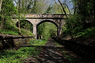
This is the site of Thorp Arch
Railway Station that straddled the line between Harrogate and Church Fenton, that also included Wetherby and Tadcaster. The disused railway has now been revitalised as The Wetherby Railway Path - Cycle Route No. 665, and an extension of the Harland Way that links to
316:
266:
458:– You must give appropriate credit, provide a link to the license, and indicate if changes were made. You may do so in any reasonable manner, but not in any way that suggests the licensor endorses you or your use.
69:
65:
61:
57:
53:
47:
82:
114:
909:
845:
203:
1158:
831:
710:
674:
638:
340:
290:
1355:
1350:
760:
73:
42:
1565:
375:
1428:
This file contains additional information, probably added from the digital camera or scanner used to create or digitize it.
465:
601:
1284:
1250:
1216:
1179:
1124:
1090:
1053:
1016:
979:
950:
923:
886:
859:
815:
723:
694:
622:
594:
579:
566:
1151:
781:
753:
738:
658:
539:
522:
1387:
362:
421:
1431:
If the file has been modified from its original state, some details may not fully reflect the modified file.
1383:
The following pages on the
English Knowledge (XXG) use this file (pages on other projects are not listed):
1623:
464:– If you remix, transform, or build upon the material, you must distribute your contributions under the
382:
on the
Geograph website for the photographer's contact details. The copyright on this image is owned by
418:
916:"}},"text\/plain":{"en":{"P7787":"315 degree"}}}}": -->
852:"}},"text\/plain":{"en":{"P7787":"315 degree"}}}}": -->
1643:
122:
235:
745:
730:
586:
219:
1450:
1440:
1366:
346:
296:
1735:
1633:
1605:
1465:
387:
109:
1505:
280:
1685:
171:
1485:
330:
182:
192:
1475:
367:
379:
1534:
1323:
Click on a date/time to view the file as it appeared at that time.
1560:
Landscape mode (for landscape photos with the background in focus)
332:
282:
267:
53° 54′ 59.11″ N, 1° 20′ 16.21″ W
307:
257:
97:
317:
53° 55′ 00.3″ N, 1° 20′ 17″ W
147:
Former Thorp Arch
Railway Station (geograph 5369248).jpg
1405:
506:
Add a one-line explanation of what this file represents
1415:
87:(5,184 × 3,456 pixels, file size: 6.79 MB, MIME type:
210:
Creative
Commons Attribution Share-alike license 2.0
141:
121:
Commons is a freely licensed media file repository.
675:
Creative
Commons Attribution-ShareAlike 2.0 Generic
1648:Flash did not fire, compulsory flash suppression
475:https://creativecommons.org/licenses/by-sa/2.0
102:
481:Creative Commons Attribution-Share Alike 2.0
399:
8:
913:
849:
441:– to copy, distribute and transmit the work
1433:
1325:
502:
1398:The following other wikis use this file:
746:https://www.geograph.org.uk/photo/5369248
1140:19018196a9596819f513b790f119a11e21e5bf75
587:https://www.geograph.org.uk/profile/3298
1767:
1759:
1751:
1743:
1733:
1725:
1717:
1709:
1701:
1693:
1683:
1675:
1667:
1659:
1651:
1641:
1631:
1621:
1613:
1603:
1582:
1574:
1563:
1555:
1547:
1539:
1529:
1521:
1513:
1502:
1494:
1483:
1473:
1463:
1455:
1445:
1385:
1298:
1282:
1264:
1248:
1230:
1214:
1193:
1177:
1138:
1122:
1104:
1088:
1067:
1051:
1030:
1014:
993:
977:
937:
921:
873:
857:
829:
813:
795:
779:
708:
692:
672:
656:
636:
620:
553:
537:
520:
517:
498:
491:
310:
260:
1373:Transferred from geograph.co.uk using
339:View this and other nearby images on:
289:View this and other nearby images on:
1435:
7:
386:and is licensed for reuse under the
1314:
422:Attribution-Share Alike 2.0 Generic
410:
405:
390:Attribution-ShareAlike 2.0 license.
1426:
511:
505:
396:
373:
151:
134:
80:
510:
250:Former Thorp Arch Railway Station
231:Former Thorp Arch Railway Station
158:Former Thorp Arch Railway Station
1756:982dd3ce0fa150296728f0a07424aca5
1496:Date and time of data generation
860:coordinates of the point of view
496:
452:Under the following conditions:
417:This file is licensed under the
409:
404:
398:
366:
345:
331:
323:
295:
281:
273:
101:
31:
21:
493:
152:
14:
711:file available on the internet
492:
374:This image was taken from the
26:
1:
924:coordinates of depicted place
875:53°54'59.108"N, 1°20'16.213"W
36:
1669:DateTimeDigitized subseconds
761:Geograph Britain and Ireland
595:object of statement has role
518:Items portrayed in this file
322:
272:
1711:Focal plane resolution unit
1661:DateTimeOriginal subseconds
1576:Date and time of digitizing
1789:
1677:Supported Flashpix version
1412:Usage on www.wikidata.org
1402:Usage on it.wikipedia.org
1388:Thorp Arch railway station
939:53°55'0.26"N, 1°20'17.16"W
466:same or compatible license
1584:Meaning of each component
1541:File change date and time
1315:
248:Chris Heaton /
229:Chris Heaton /
16:
1703:Focal plane Y resolution
1695:Focal plane X resolution
724:geograph.org.uk image ID
495:
432:
108:This is a file from the
1719:Custom image processing
1372:
220:required by the license
198:
188:
177:
170:
167:
144:
112:. Information from its
380:this photograph's page
351:53.916740; -1.338100
301:53.916419; -1.337837
115:description page there
46:Size of this preview:
1515:Horizontal resolution
1579:10:18, 28 April 2017
1544:20:50, 29 April 2017
1499:10:18, 28 April 2017
1152:determination method
74:5,184 × 3,456 pixels
70:2,560 × 1,707 pixels
1653:DateTime subseconds
1549:Y and C positioning
1523:Vertical resolution
1437:Camera manufacturer
447:– to adapt the work
52:Other resolutions:
1745:Scene capture type
1740:Auto white balance
1351:15:55, 9 July 2017
567:author name string
66:1,280 × 853 pixels
62:1,024 × 683 pixels
1776:
1775:
1761:Rating (out of 5)
1470:1/125 sec (0.008)
1394:Global file usage
1376:
915:
851:
659:copyright license
504:
395:
394:
378:collection. See
356:
355:
306:
305:
255:
254:
223:
207:
204:Reusing this file
130:
129:
110:Wikimedia Commons
32:Global file usage
1780:
1706:5,808.4033613445
1698:5,728.1767955801
1557:Exposure Program
1434:
1363:
1303:
1198:
1161:
1156:
1072:
1035:
998:
961:
960:
955:
897:
896:
891:
763:
758:
748:
743:
739:described at URL
733:
728:
623:copyright status
604:
599:
589:
584:
574:
571:
488:
485:
482:
479:
476:
468:as the original.
430:
419:Creative Commons
413:
412:
408:
407:
402:
401:
388:Creative Commons
376:Geograph project
370:
363:
352:
349:
335:
334:
328:
327:
326:
320:
319:
308:
302:
299:
285:
284:
278:
277:
276:
270:
269:
258:
217:
201:
173:
156:
148:
142:
126:
105:
104:
98:
92:
90:
77:
58:640 × 427 pixels
54:320 × 213 pixels
48:800 × 533 pixels
1788:
1787:
1783:
1782:
1781:
1779:
1778:
1777:
1753:Unique image ID
1451:Canon EOS 1200D
1422:
1392:
1384:
1377:
1369:
1361:
1317:
1316:
1313:
1312:
1311:
1310:
1309:
1308:
1307:
1306:
1304:
1301:
1291:
1290:
1289:
1287:
1276:
1275:
1274:
1273:
1272:
1271:
1270:
1269:
1267:
1257:
1256:
1255:
1253:
1242:
1241:
1240:
1239:
1238:
1237:
1236:
1235:
1233:
1223:
1222:
1221:
1219:
1208:
1207:
1206:
1205:
1204:
1203:
1202:
1201:
1199:
1196:
1186:
1185:
1184:
1182:
1171:
1170:
1169:
1168:
1167:
1166:
1165:
1164:
1163:
1162:
1157:
1154:
1145:
1144:
1143:
1141:
1131:
1130:
1129:
1127:
1116:
1115:
1114:
1113:
1112:
1111:
1110:
1109:
1107:
1097:
1096:
1095:
1093:
1082:
1081:
1080:
1079:
1078:
1077:
1076:
1075:
1073:
1070:
1060:
1059:
1058:
1056:
1045:
1044:
1043:
1042:
1041:
1040:
1039:
1038:
1036:
1033:
1023:
1022:
1021:
1019:
1008:
1007:
1006:
1005:
1004:
1003:
1002:
1001:
999:
996:
986:
985:
984:
982:
971:
970:
969:
968:
967:
966:
965:
964:
963:
962:
958:
956:
953:
944:
943:
942:
940:
930:
929:
928:
926:
907:
906:
905:
904:
903:
902:
901:
900:
899:
898:
894:
892:
889:
880:
879:
878:
876:
866:
865:
864:
862:
843:
842:
841:
840:
839:
838:
837:
836:
834:
832:Canon EOS 1200D
822:
821:
820:
818:
807:
806:
805:
804:
803:
802:
801:
800:
798:
788:
787:
786:
784:
773:
772:
771:
770:
769:
768:
767:
766:
765:
764:
759:
756:
750:
749:
744:
741:
735:
734:
729:
726:
717:
716:
715:
713:
701:
700:
699:
697:
686:
685:
684:
683:
682:
681:
680:
679:
677:
665:
664:
663:
661:
650:
649:
648:
647:
646:
645:
644:
643:
641:
629:
628:
627:
625:
614:
613:
612:
611:
610:
609:
608:
607:
606:
605:
600:
597:
591:
590:
585:
582:
576:
575:
572:
569:
560:
559:
558:
556:
546:
545:
544:
542:
531:
530:
529:
528:
527:
525:
509:
508:
507:
490:
489:
486:
483:
480:
477:
474:
473:
431:
428:
425:
414:
391:
361:
350:
324:
315:
314:
311:Object location
300:
274:
265:
264:
261:Camera location
256:
245:
238:
226:
183:geograph.org.uk
163:
146:
139:
132:
131:
120:
119:
118:is shown below.
94:
88:
86:
79:
78:
51:
12:
11:
5:
1786:
1784:
1774:
1773:
1770:
1766:
1765:
1762:
1758:
1757:
1754:
1750:
1749:
1746:
1742:
1741:
1738:
1732:
1731:
1728:
1724:
1723:
1722:Normal process
1720:
1716:
1715:
1712:
1708:
1707:
1704:
1700:
1699:
1696:
1692:
1691:
1688:
1682:
1681:
1678:
1674:
1673:
1670:
1666:
1665:
1662:
1658:
1657:
1654:
1650:
1649:
1646:
1640:
1639:
1636:
1630:
1629:
1626:
1620:
1619:
1616:
1612:
1611:
1608:
1602:
1601:
1600:
1599:
1598:does not exist
1596:
1593:
1590:
1585:
1581:
1580:
1577:
1573:
1572:
1569:
1562:
1561:
1558:
1554:
1553:
1550:
1546:
1545:
1542:
1538:
1537:
1532:
1528:
1527:
1524:
1520:
1519:
1516:
1512:
1511:
1508:
1501:
1500:
1497:
1493:
1492:
1489:
1482:
1481:
1478:
1472:
1471:
1468:
1462:
1461:
1458:
1454:
1453:
1448:
1444:
1443:
1438:
1425:
1421:
1420:
1419:
1418:
1410:
1409:
1408:
1396:
1395:
1391:
1390:
1382:
1381:
1380:
1375:
1374:
1371:
1367:
1364:
1360:5,184 × 3,456
1358:
1353:
1348:
1344:
1343:
1340:
1337:
1334:
1331:
1328:
1321:
1320:
1305:
1299:
1297:
1296:
1295:
1294:
1293:
1292:
1288:
1283:
1281:
1280:
1279:
1278:
1277:
1268:
1265:
1263:
1262:
1261:
1260:
1259:
1258:
1254:
1249:
1247:
1246:
1245:
1244:
1243:
1234:
1231:
1229:
1228:
1227:
1226:
1225:
1224:
1220:
1215:
1213:
1212:
1211:
1210:
1209:
1200:
1194:
1192:
1191:
1190:
1189:
1188:
1187:
1183:
1178:
1176:
1175:
1174:
1173:
1172:
1150:
1149:
1148:
1147:
1146:
1142:
1139:
1137:
1136:
1135:
1134:
1133:
1132:
1128:
1123:
1121:
1120:
1119:
1118:
1117:
1108:
1105:
1103:
1102:
1101:
1100:
1099:
1098:
1094:
1089:
1087:
1086:
1085:
1084:
1083:
1074:
1068:
1066:
1065:
1064:
1063:
1062:
1061:
1057:
1052:
1050:
1049:
1048:
1047:
1046:
1037:
1031:
1029:
1028:
1027:
1026:
1025:
1024:
1020:
1015:
1013:
1012:
1011:
1010:
1009:
1000:
994:
992:
991:
990:
989:
988:
987:
983:
978:
976:
975:
974:
973:
972:
949:
948:
947:
946:
945:
941:
938:
936:
935:
934:
933:
932:
931:
927:
922:
920:
919:
918:
917:
911:
885:
884:
883:
882:
881:
877:
874:
872:
871:
870:
869:
868:
867:
863:
858:
856:
855:
854:
853:
847:
835:
830:
828:
827:
826:
825:
824:
823:
819:
814:
812:
811:
810:
809:
808:
799:
796:
794:
793:
792:
791:
790:
789:
785:
780:
778:
777:
776:
775:
774:
752:
751:
737:
736:
722:
721:
720:
719:
718:
714:
709:
707:
706:
705:
704:
703:
702:
698:
695:source of file
693:
691:
690:
689:
688:
687:
678:
673:
671:
670:
669:
668:
667:
666:
662:
657:
655:
654:
653:
652:
651:
642:
637:
635:
634:
633:
632:
631:
630:
626:
621:
619:
618:
617:
616:
615:
593:
592:
578:
577:
565:
564:
563:
562:
561:
557:
554:
552:
551:
550:
549:
548:
547:
543:
538:
536:
535:
534:
533:
532:
526:
521:
519:
516:
515:
514:
513:
512:
501:
500:
497:
494:
472:
471:
470:
469:
459:
450:
449:
448:
442:
435:You are free:
426:
416:
415:
397:
393:
392:
371:
360:
357:
354:
353:
343:
337:
312:
304:
303:
293:
287:
262:
253:
252:
246:
243:
240:
239:
234:
227:
224:
212:
211:
208:
196:
195:
190:
186:
185:
179:
175:
174:
169:
165:
164:
149:
140:
138:
135:
133:
128:
127:
106:
96:
95:
45:
41:
40:
39:
34:
29:
24:
19:
13:
10:
9:
6:
4:
3:
2:
1785:
1771:
1768:
1763:
1760:
1755:
1752:
1747:
1744:
1739:
1737:
1736:White balance
1734:
1730:Auto exposure
1729:
1727:Exposure mode
1726:
1721:
1718:
1713:
1710:
1705:
1702:
1697:
1694:
1689:
1687:
1684:
1679:
1676:
1671:
1668:
1663:
1660:
1655:
1652:
1647:
1645:
1642:
1637:
1635:
1634:Metering mode
1632:
1627:
1625:
1624:Exposure bias
1622:
1617:
1615:APEX aperture
1614:
1609:
1607:
1606:Shutter speed
1604:
1597:
1594:
1591:
1588:
1587:
1586:
1583:
1578:
1575:
1570:
1567:
1564:
1559:
1556:
1551:
1548:
1543:
1540:
1536:
1533:
1531:Software used
1530:
1525:
1522:
1517:
1514:
1509:
1507:
1503:
1498:
1495:
1490:
1487:
1484:
1479:
1477:
1474:
1469:
1467:
1466:Exposure time
1464:
1459:
1456:
1452:
1449:
1446:
1442:
1439:
1436:
1432:
1429:
1423:
1417:
1414:
1413:
1411:
1407:
1404:
1403:
1401:
1400:
1399:
1393:
1389:
1386:
1378:
1370:
1365:
1359:
1357:
1354:
1352:
1349:
1346:
1345:
1341:
1338:
1335:
1332:
1329:
1327:
1326:
1324:
1318:
1286:
1252:
1218:
1181:
1180:exposure time
1160:
1153:
1126:
1092:
1055:
1018:
981:
952:
925:
888:
861:
833:
817:
816:captured with
797:28 April 2017
783:
762:
755:
747:
740:
732:
725:
712:
696:
676:
660:
640:
624:
603:
596:
588:
581:
568:
541:
524:
478:CC BY-SA 2.0
467:
463:
460:
457:
454:
453:
451:
446:
443:
440:
437:
436:
434:
433:
427:Attribution:
423:
420:
403:
389:
385:
381:
377:
372:
369:
365:
364:
358:
348:
344:
342:
341:OpenStreetMap
338:
336:
318:
313:
309:
298:
294:
292:
291:OpenStreetMap
288:
286:
268:
263:
259:
251:
247:
242:
241:
237:
233: /
232:
228:
221:
216:
214:
213:
209:
205:
200:
197:
194:
191:
187:
184:
180:
176:
172:28 April 2017
166:
160:
159:
155:
150:
143:
136:
124:
117:
116:
111:
107:
100:
99:
93:
84:
83:Original file
75:
71:
67:
63:
59:
55:
49:
44:
38:
35:
33:
30:
28:
25:
23:
20:
18:
15:
1506:focal length
1447:Camera model
1430:
1427:
1397:
1322:
1319:File history
1285:focal length
602:photographer
573:Chris Heaton
461:
455:
444:
438:
429:Chris Heaton
384:Chris Heaton
383:
321:
271:
249:
236:CC BY-SA 2.0
230:
193:Chris Heaton
157:
153:
123:You can help
113:
81:
22:File history
1769:IIM version
1686:Color space
639:copyrighted
462:share alike
456:attribution
215:Attribution
145:Description
1406:Thorp Arch
1379:File usage
1368:Mtaylor848
1336:Dimensions
1302:millimetre
1106:image/jpeg
1091:media type
995:7,124,080
555:some value
199:Permission
162:Spofforth.
89:image/jpeg
27:File usage
1486:ISO speed
1416:Q38251947
1362:(6.79 MB)
1333:Thumbnail
1330:Date/Time
1251:ISO speed
980:data size
782:inception
359:Licensing
244:InfoField
225:InfoField
154:English:
1748:Standard
1552:Co-sited
1476:F-number
1424:Metadata
1217:f-number
1125:checksum
754:operator
499:Captions
445:to remix
439:to share
424:license.
37:Metadata
1638:Pattern
1568:version
1347:current
1342:Comment
951:heading
910:heading
887:heading
846:heading
731:5369248
540:creator
523:depicts
503:English
137:Summary
85:
1714:inches
1535:Picasa
1526:72 dpi
1518:72 dpi
1488:rating
1460:Picasa
1457:Author
1197:second
1195:0.008
1069:5,184
1032:3,456
1017:height
959:degree
914:degree
895:degree
850:degree
329:
279:
189:Author
178:Source
1644:Flash
1510:25 mm
1504:Lens
1441:Canon
1159:SHA-1
1071:pixel
1054:width
1034:pixel
181:From
1690:sRGB
1566:Exif
1480:f/11
1339:User
997:byte
957:315
893:315
487:true
484:true
168:Date
17:File
1571:2.3
1491:100
1300:25
1266:100
580:URL
1672:00
1664:00
1656:00
1595:Cr
1592:Cb
1232:11
1155::
954::
890::
757::
742::
727::
598::
583::
570::
72:|
68:|
64:|
60:|
56:|
50:.
1772:4
1764:0
1680:1
1628:0
1618:7
1610:7
1589:Y
222:)
218:(
206:)
202:(
125:.
91:)
76:.
Text is available under the Creative Commons Attribution-ShareAlike License. Additional terms may apply.

.jpg)
.jpg¶ms=053.916419_N_-001.337837_E_globe:Earth_type:camera_heading:315.00_source:geograph&language=en)
.jpg¶ms=053.916740_N_-001.338100_E_globe:Earth_class:object_type:object_source:geograph-osgb36(SE43574693)_region:GB-GBN_heading:315.00&language=en)