165:
43:
334:
295:
245:
287:
425:
309:
259:
340:
345:
103:
778:"}},"text\/plain":{"en":{"":"heading"}}},"{\"value\":{\"amount\":\"+315\",\"unit\":\"http:\\\/\\\/www.wikidata.org\\\/entity\\\/Q28390\"},\"type\":\"quantity\"}":{"text\/html":{"en":{"P7787":"315
774:
967:{{Information |Description ={{en|1=Fort Montgomery in Rouses Point, NY. Photo taken from a fishing access parking lot on the north side of the Rouses Point Bridge (US Route 2) in Vermont. Fort is .68 mile due NW of camera position.}} |Source =
278:
386:– You must give appropriate credit, provide a link to the license, and indicate if changes were made. You may do so in any reasonable manner, but not in any way that suggests the licensor endorses you or your use.
236:
157:
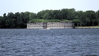
Fort
Montgomery in Rouses Point, NY. Photo taken from a fishing access parking lot on the north side of the Rouses Point Bridge (US Route 2) in Vermont. Fort is .68 mile due NW of camera position.
775:
442:
69:
65:
61:
57:
53:
47:
114:
82:
172:
440:; with no Invariant Sections, no Front-Cover Texts, and no Back-Cover Texts. A copy of the license is included in the section entitled
432:
981:
761:
691:
674:
638:
302:
252:
861:
1047:
This file contains additional information, probably added from the digital camera or scanner used to create or digitize it.
519:
393:
881:
845:
816:
789:
745:
622:
594:
581:
566:
437:
711:
658:
539:
503:
999:
601:
355:
1050:
If the file has been modified from its original state, some details may not fully reflect the modified file.
977:
The following pages on the
English Knowledge (XXG) use this file (pages on other projects are not listed):
392:– If you remix, transform, or build upon the material, you must distribute your contributions under the
949:
944:
352:
73:
42:
782:"}},"text\/plain":{"en":{"P7787":"315 degree"}}}}": -->
122:
419:
573:
430:
Permission is granted to copy, distribute and/or modify this document under the terms of the
308:
258:
181:
327:
I, the copyright holder of this work, hereby publish it under the following licenses:
109:
960:
292:
242:
199:
159:
219:
1014:
917:
Click on a date/time to view the file as it appeared at that time.
874:
176:
294:
279:
44° 59′ 55.88″ N, 73° 20′ 19.08″ W
244:
237:
45° 00′ 19.92″ N, 73° 20′ 57.7″ W
269:
227:
171:
This is an image of a place or building that is listed on the
97:
1024:
1009:
87:(3,950 × 2,220 pixels, file size: 6.72 MB, MIME type:
1034:
692:
Creative
Commons Attribution-ShareAlike 3.0 Unported
675:
436:, Version 1.2 or any later version published by the
141:
121:
Commons is a freely licensed media file repository.
403:https://creativecommons.org/licenses/by-sa/3.0
102:
409:Creative Commons Attribution-Share Alike 3.0
333:
8:
779:
369:– to copy, distribute and transmit the work
1052:
919:
574:https://commons.wikimedia.org/user:Mfwills
483:
468:You may select the license of your choice.
992:The following other wikis use this file:
1054:
979:
895:
879:
859:
843:
803:
787:
759:
743:
725:
709:
689:
672:
656:
636:
620:
553:
537:
517:
501:
498:
479:
472:
272:
230:
301:View this and other nearby images on:
251:View this and other nearby images on:
7:
448:http://www.gnu.org/copyleft/fdl.html
356:Attribution-Share Alike 3.0 Unported
173:National Register of Historic Places
908:
344:
339:
147:Fort Montgomery Rouses Point NY.jpg
1045:
492:
486:
467:
330:
326:
151:
134:
80:
491:
982:Fort Montgomery (Lake Champlain)
790:coordinates of the point of view
477:
424:
423:
380:Under the following conditions:
351:This file is licensed under the
343:
338:
332:
307:
293:
285:
257:
243:
163:
101:
31:
21:
474:
152:
14:
805:44°59'55.882"N, 73°20'19.079"W
473:
454:GNU Free Documentation License
443:GNU Free Documentation License
433:GNU Free Documentation License
26:
1:
897:45°0'19.919"N, 73°20'57.700"W
882:coordinates of depicted place
762:original creation by uploader
36:
499:Items portrayed in this file
284:
1006:Usage on en.wikivoyage.org
996:Usage on arz.wikipedia.org
1076:
1031:Usage on www.wikidata.org
1021:Usage on fr.wikipedia.org
1015:Champlain and Rouses Point
394:same or compatible license
179:. Its reference number is
909:
209:
16:
476:
438:Free Software Foundation
360:
177:United States of America
108:This is a file from the
966:
215:
205:
198:
195:
144:
112:. Information from its
313:44.998856; -73.338633
263:45.005533; -73.349361
115:description page there
46:Size of this preview:
846:location of creation
74:3,950 × 2,220 pixels
70:2,560 × 1,439 pixels
945:10:10, 18 July 2011
375:– to adapt the work
52:Other resolutions:
595:Wikimedia username
582:author name string
66:1,280 × 719 pixels
62:1,024 × 576 pixels
1063:
1062:
988:Global file usage
970:
781:
659:copyright license
485:
465:
464:
318:
317:
268:
267:
225:
224:
191:
190:
130:
129:
110:Wikimedia Commons
32:Global file usage
1067:
1053:
957:
827:
826:
821:
623:copyright status
604:
599:
589:
586:
576:
571:
461:
458:
455:
452:
449:
427:
426:
420:
416:
413:
410:
407:
404:
396:as the original.
353:Creative Commons
347:
346:
342:
341:
336:
335:
314:
311:
297:
296:
290:
289:
288:
282:
281:
270:
264:
261:
247:
246:
240:
239:
228:
211:
201:
184:
167:
166:
160:
156:
148:
142:
126:
105:
104:
98:
92:
90:
77:
58:640 × 360 pixels
54:320 × 180 pixels
48:800 × 450 pixels
1075:
1074:
1070:
1069:
1068:
1066:
1065:
1064:
1041:
1025:Fort Montgomery
986:
978:
971:
963:
955:
911:
910:
907:
906:
905:
904:
903:
902:
901:
900:
898:
888:
887:
886:
884:
873:
872:
871:
870:
869:
868:
867:
866:
864:
852:
851:
850:
848:
837:
836:
835:
834:
833:
832:
831:
830:
829:
828:
824:
822:
819:
810:
809:
808:
806:
796:
795:
794:
792:
773:
772:
771:
770:
769:
768:
767:
766:
764:
752:
751:
750:
748:
737:
736:
735:
734:
733:
732:
731:
730:
728:
718:
717:
716:
714:
703:
702:
701:
700:
699:
698:
697:
696:
694:
683:
682:
681:
680:
679:
677:
665:
664:
663:
661:
650:
649:
648:
647:
646:
645:
644:
643:
641:
629:
628:
627:
625:
614:
613:
612:
611:
610:
609:
608:
607:
606:
605:
600:
597:
591:
590:
587:
584:
578:
577:
572:
569:
560:
559:
558:
556:
546:
545:
544:
542:
531:
530:
529:
528:
527:
526:
525:
524:
522:
520:Fort Montgomery
510:
509:
508:
506:
490:
489:
488:
471:
470:
469:
459:
456:
453:
450:
447:
418:
417:
414:
411:
408:
405:
402:
401:
359:
348:
329:
328:
323:
312:
286:
277:
276:
273:Camera location
262:
235:
234:
231:Object location
226:
180:
164:
158:
146:
139:
132:
131:
120:
119:
118:is shown below.
94:
88:
86:
79:
78:
51:
12:
11:
5:
1073:
1071:
1061:
1060:
1057:
1044:
1040:
1039:
1038:
1037:
1029:
1028:
1027:
1019:
1018:
1017:
1012:
1004:
1003:
1002:
990:
989:
985:
984:
976:
975:
974:
969:
968:
965:
961:
958:
954:3,950 × 2,220
952:
947:
942:
938:
937:
934:
931:
928:
925:
922:
915:
914:
899:
896:
894:
893:
892:
891:
890:
889:
885:
880:
878:
877:
876:
875:
865:
860:
858:
857:
856:
855:
854:
853:
849:
844:
842:
841:
840:
839:
838:
815:
814:
813:
812:
811:
807:
804:
802:
801:
800:
799:
798:
797:
793:
788:
786:
785:
784:
783:
777:
765:
760:
758:
757:
756:
755:
754:
753:
749:
746:source of file
744:
742:
741:
740:
739:
738:
729:
726:
724:
723:
722:
721:
720:
719:
715:
710:
708:
707:
706:
705:
704:
695:
690:
688:
687:
686:
685:
684:
678:
673:
671:
670:
669:
668:
667:
666:
662:
657:
655:
654:
653:
652:
651:
642:
637:
635:
634:
633:
632:
631:
630:
626:
621:
619:
618:
617:
616:
615:
593:
592:
580:
579:
565:
564:
563:
562:
561:
557:
554:
552:
551:
550:
549:
548:
547:
543:
538:
536:
535:
534:
533:
532:
523:
518:
516:
515:
514:
513:
512:
511:
507:
502:
500:
497:
496:
495:
494:
493:
487:"Fort Blunder"
482:
481:
478:
475:
466:
463:
462:
428:
400:
399:
398:
397:
387:
378:
377:
376:
370:
363:You are free:
350:
349:
331:
325:
324:
322:
319:
316:
315:
305:
299:
274:
266:
265:
255:
249:
232:
223:
222:
217:
213:
212:
207:
203:
202:
197:
193:
192:
189:
188:
168:
149:
140:
138:
135:
133:
128:
127:
106:
96:
95:
45:
41:
40:
39:
34:
29:
24:
19:
13:
10:
9:
6:
4:
3:
2:
1072:
1058:
1055:
1051:
1048:
1042:
1036:
1033:
1032:
1030:
1026:
1023:
1022:
1020:
1016:
1013:
1011:
1010:North Country
1008:
1007:
1005:
1001:
998:
997:
995:
994:
993:
987:
983:
980:
972:
964:
959:
953:
951:
948:
946:
943:
940:
939:
935:
932:
929:
926:
923:
921:
920:
918:
912:
883:
863:
847:
818:
791:
763:
747:
713:
693:
676:
660:
640:
624:
603:
596:
583:
575:
568:
541:
521:
505:
445:
444:
439:
435:
434:
429:
422:
421:
406:CC BY-SA 3.0
395:
391:
388:
385:
382:
381:
379:
374:
371:
368:
365:
364:
362:
361:
357:
354:
337:
320:
310:
306:
304:
303:OpenStreetMap
300:
298:
280:
275:
271:
260:
256:
254:
253:OpenStreetMap
250:
248:
238:
233:
229:
221:
218:
214:
208:
204:
194:
187:
186:
183:
178:
174:
169:
162:
161:
155:
150:
143:
136:
124:
117:
116:
111:
107:
100:
99:
93:
84:
83:Original file
75:
71:
67:
63:
59:
55:
49:
44:
38:
35:
33:
30:
28:
25:
23:
20:
18:
15:
1049:
1046:
1000:حصن مونتجمرى
991:
916:
913:File history
862:Rouses Point
727:17 July 2011
441:
431:
389:
383:
372:
366:
283:
200:17 July 2011
170:
153:
123:You can help
113:
81:
22:File history
639:copyrighted
390:share alike
384:attribution
145:Description
1056:_error
973:File usage
930:Dimensions
555:some value
89:image/jpeg
27:File usage
956:(6.72 MB)
927:Thumbnail
924:Date/Time
712:inception
321:Licensing
154:English:
1043:Metadata
480:Captions
373:to remix
367:to share
358:license.
210:Own work
182:77000937
37:Metadata
1035:Q742101
962:Mfwills
941:current
936:Comment
817:heading
776:heading
602:Mfwills
588:Mfwills
540:creator
504:depicts
484:English
220:Mfwills
175:in the
137:Summary
85:
825:degree
780:degree
291:
241:
216:Author
206:Source
933:User
823:315
460:true
457:true
451:GFDL
415:true
412:true
196:Date
17:File
567:URL
820::
598::
585::
570::
72:|
68:|
64:|
60:|
56:|
50:.
1059:0
446:.
185:.
125:.
91:)
76:.
Text is available under the Creative Commons Attribution-ShareAlike License. Additional terms may apply.
