43:
154:
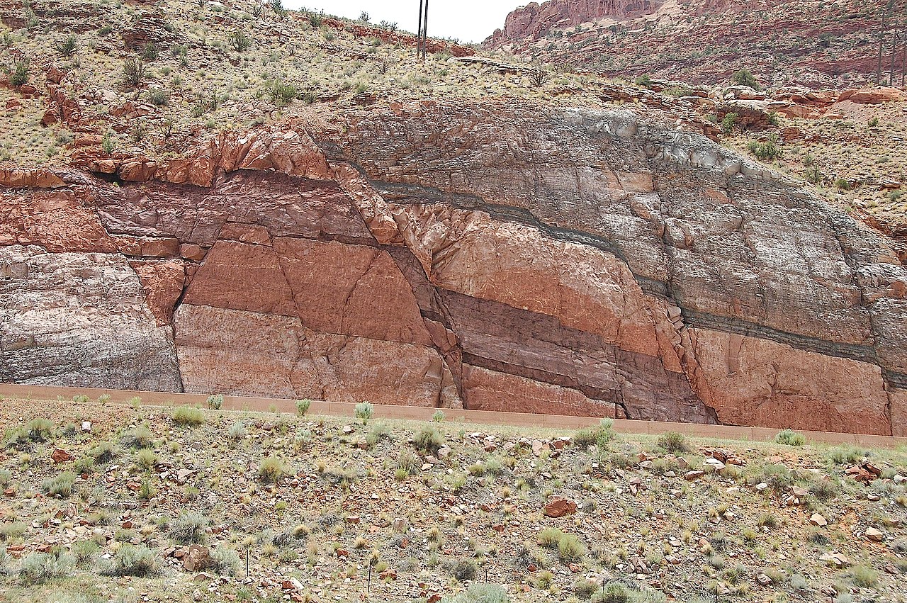
This outcrop occurs across highway 191, immediately opposite and directly south of, the visitor center parking lot at Arches
National Park. The Honaker Trail Formation underlies the visible strata throughout the area, but is buried and impossible to view elsewhere in the near vicinity of Moab. The fault and the road cut for highway 191 provide a rare circumstance where visitors to Moab, Arches National Park, and Canyonlands National Park may see this approximately 300 miilion year old Pennsylvanian Period layer of rock.
295:
223:
258:
237:
301:
99:
836:
153:
This image shows one of the only outcrops of the
Pennsylvanian Period Honaker Trail Formation that may be viewed in the vicinity of Moab. In this setting the Honaker Trail Formation serves as the base of a strata graphic sequence which form the cliffs that occur on the west side of the Moab valley.
214:
342:– You must give appropriate credit, provide a link to the license, and indicate if changes were made. You may do so in any reasonable manner, but not in any way that suggests the licensor endorses you or your use.
65:
61:
57:
53:
47:
110:
78:
910:
935:
380:
This image shows one of the only outcrops of the
Pennsylvanian Period Honaker Trail Formation that may be viewed in the vicinity of Moab
535:
465:
429:
230:
1077:
948:
This file contains additional information, probably added from the digital camera or scanner used to create or digitize it.
900:
781:
835:
830:
69:
42:
731:
697:
660:
626:
589:
555:
519:
413:
165:
485:
449:
396:
765:
186:
951:
If the file has been modified from its original state, some details may not fully reflect the modified file.
863:
The following pages on the
English Knowledge (XXG) use this file (pages on other projects are not listed):
1104:
311:
308:
1140:
118:
1261:
1054:
960:
936:
Wikidata:WikiProject
Geology/Lists of sedimentary units by country/United States of America
160:
270:
846:
276:
236:
1216:
1122:
977:
166:
http://geology.byu.edu/home/sites/default/files/geo-stud-volume-19-part-2-melton1.pdf
105:
1271:
1226:
1017:
220:
1182:
176:
997:
970:
867:
197:
187:
https://www.flickr.com/photos/jsjgeology/8471260787/in/set-72157632763455730
890:
1281:
987:
265:
803:
Click on a date/time to view the file as it appeared at that time.
548:
281:
and was confirmed to be licensed under the terms of the cc-by-2.0.
885:
920:
215:
38° 36′ 51.75″ N, 109° 37′ 14.04″ W
222:
205:
93:
143:
Faults in
Moenkopi Formation Moab Canyon Utah USA 01.jpg
161:
http://www.gly.uga.edu/railsback/VFT/VFTMoabFault.html
83:(3,008 × 2,000 pixels, file size: 3.63 MB, MIME type:
930:
271:
https://www.flickr.com/photos/47445767@N05/8471260787
137:
117:
Commons is a freely licensed media file repository.
98:
294:
8:
349:https://creativecommons.org/licenses/by/2.0
325:– to copy, distribute and transmit the work
953:
805:
376:
878:The following other wikis use this file:
273:. It was reviewed on 14 December 2013 by
198:https://www.flickr.com/people/jsjgeology/
466:Creative Commons Attribution 2.0 Generic
1289:
1279:
1269:
1259:
1251:
1243:
1235:
1224:
1214:
1206:
1198:
1190:
1180:
1172:
1164:
1156:
1148:
1138:
1130:
1120:
1112:
1102:
1094:
1086:
1075:
1067:
1059:
1049:
1041:
1033:
1025:
1014:
1006:
995:
985:
975:
965:
865:
779:
763:
745:
729:
711:
695:
674:
658:
640:
624:
603:
587:
569:
553:
533:
517:
499:
483:
463:
447:
427:
411:
394:
391:
372:
365:
208:
229:View this and other nearby images on:
955:
7:
263:This image was originally posted to
252:
853:User created page with UploadWizard
794:
300:
946:
385:
379:
316:
291:
147:
130:
76:
384:
355:Creative Commons Attribution 2.0
1008:Date and time of data generation
370:
336:Under the following conditions:
307:This file is licensed under the
299:
293:
256:
235:
221:
97:
31:
21:
571:38°36'51.746"N, 109°37'14.041"W
367:
148:
14:
366:
26:
1:
556:coordinates of depicted place
36:
1166:DateTimeDigitized subseconds
392:Items portrayed in this file
1158:DateTimeOriginal subseconds
1088:Date and time of digitizing
1311:
1237:Focal length in 35 mm film
1195:One-chip color area sensor
1174:Supported Flashpix version
927:Usage on www.wikidata.org
917:Usage on sk.wikipedia.org
907:Usage on ky.wikipedia.org
897:Usage on he.wikipedia.org
882:Usage on fr.wikipedia.org
1061:File change date and time
891:Portail:Géologie/Articles
795:
196:James St. John (jsj1771)
16:
369:
104:This is a file from the
1200:Custom image processing
852:
831:17:58, 14 December 2013
312:Attribution 2.0 Generic
192:
182:
175:
172:
140:
108:. Information from its
1291:Subject distance range
1096:Image compression mode
241:38.614374; -109.620567
111:description page there
46:Size of this preview:
1114:Maximum land aperture
1035:Horizontal resolution
982:1/320 sec (0.003125)
70:3,008 × 2,000 pixels
1150:DateTime subseconds
1091:14:54, 17 June 2007
1064:14:54, 17 June 2007
1043:Vertical resolution
1011:14:54, 17 June 2007
957:Camera manufacturer
911:Тектоникалык жарака
331:– to adapt the work
52:Other resolutions:
1245:Scene capture type
1221:Auto white balance
1145:Flash did not fire
66:1,280 × 851 pixels
62:1,024 × 681 pixels
1298:
1297:
1117:4.3 APEX (f/4.44)
961:NIKON CORPORATION
874:Global file usage
856:
450:copyright license
378:
285:
284:
246:
245:
203:
202:
126:
125:
106:Wikimedia Commons
32:Global file usage
1302:
1069:Exposure Program
954:
886:Portail:Géologie
843:
679:
608:
414:copyright status
362:
359:
356:
353:
350:
309:Creative Commons
303:
302:
297:
296:
289:
288:14 December 2013
279:
260:
259:
253:
242:
239:
225:
224:
218:
217:
206:
178:
152:
144:
138:
122:
101:
100:
94:
88:
86:
73:
58:640 × 426 pixels
54:320 × 213 pixels
48:800 × 532 pixels
1310:
1309:
1305:
1304:
1303:
1301:
1300:
1299:
942:
921:Zlom (geológia)
872:
864:
857:
849:
841:
797:
796:
793:
792:
791:
790:
789:
788:
787:
786:
784:
772:
771:
770:
768:
757:
756:
755:
754:
753:
752:
751:
750:
748:
738:
737:
736:
734:
723:
722:
721:
720:
719:
718:
717:
716:
714:
704:
703:
702:
700:
689:
688:
687:
686:
685:
684:
683:
682:
680:
677:
667:
666:
665:
663:
652:
651:
650:
649:
648:
647:
646:
645:
643:
633:
632:
631:
629:
618:
617:
616:
615:
614:
613:
612:
611:
609:
606:
596:
595:
594:
592:
581:
580:
579:
578:
577:
576:
575:
574:
572:
562:
561:
560:
558:
547:
546:
545:
544:
543:
542:
541:
540:
538:
526:
525:
524:
522:
511:
510:
509:
508:
507:
506:
505:
504:
502:
492:
491:
490:
488:
477:
476:
475:
474:
473:
472:
471:
470:
468:
456:
455:
454:
452:
441:
440:
439:
438:
437:
436:
435:
434:
432:
420:
419:
418:
416:
405:
404:
403:
402:
401:
399:
383:
382:
381:
364:
363:
360:
357:
354:
351:
348:
347:
315:
304:
287:
275:
257:
251:
240:
213:
212:
209:Object location
204:
168:
142:
135:
128:
127:
116:
115:
114:is shown below.
90:
84:
82:
75:
74:
51:
12:
11:
5:
1308:
1306:
1296:
1295:
1292:
1288:
1287:
1284:
1278:
1277:
1274:
1268:
1267:
1264:
1258:
1257:
1254:
1250:
1249:
1246:
1242:
1241:
1238:
1234:
1233:
1230:
1223:
1222:
1219:
1213:
1212:
1209:
1205:
1204:
1203:Normal process
1201:
1197:
1196:
1193:
1192:Sensing method
1189:
1188:
1185:
1179:
1178:
1175:
1171:
1170:
1167:
1163:
1162:
1159:
1155:
1154:
1151:
1147:
1146:
1143:
1137:
1136:
1133:
1129:
1128:
1125:
1119:
1118:
1115:
1111:
1110:
1107:
1101:
1100:
1097:
1093:
1092:
1089:
1085:
1084:
1081:
1074:
1073:
1070:
1066:
1065:
1062:
1058:
1057:
1052:
1048:
1047:
1044:
1040:
1039:
1036:
1032:
1031:
1028:
1024:
1023:
1020:
1013:
1012:
1009:
1005:
1004:
1001:
994:
993:
990:
984:
983:
980:
974:
973:
968:
964:
963:
958:
945:
941:
940:
939:
938:
933:
925:
924:
923:
915:
914:
913:
905:
904:
903:
901:תצורת מואנקופי
895:
894:
893:
888:
876:
875:
871:
870:
862:
861:
860:
855:
854:
851:
847:
844:
840:3,008 × 2,000
838:
833:
828:
824:
823:
820:
817:
814:
811:
808:
801:
800:
785:
780:
778:
777:
776:
775:
774:
773:
769:
764:
762:
761:
760:
759:
758:
749:
746:
744:
743:
742:
741:
740:
739:
735:
730:
728:
727:
726:
725:
724:
715:
712:
710:
709:
708:
707:
706:
705:
701:
696:
694:
693:
692:
691:
690:
681:
675:
673:
672:
671:
670:
669:
668:
664:
659:
657:
656:
655:
654:
653:
644:
641:
639:
638:
637:
636:
635:
634:
630:
625:
623:
622:
621:
620:
619:
610:
604:
602:
601:
600:
599:
598:
597:
593:
588:
586:
585:
584:
583:
582:
573:
570:
568:
567:
566:
565:
564:
563:
559:
554:
552:
551:
550:
549:
539:
534:
532:
531:
530:
529:
528:
527:
523:
518:
516:
515:
514:
513:
512:
503:
500:
498:
497:
496:
495:
494:
493:
489:
484:
482:
481:
480:
479:
478:
469:
464:
462:
461:
460:
459:
458:
457:
453:
448:
446:
445:
444:
443:
442:
433:
428:
426:
425:
424:
423:
422:
421:
417:
412:
410:
409:
408:
407:
406:
400:
395:
393:
390:
389:
388:
387:
386:
375:
374:
371:
368:
346:
345:
344:
343:
334:
333:
332:
326:
319:You are free:
306:
305:
292:
283:
282:
269:by jsj1771 at
261:
250:
247:
244:
243:
233:
227:
210:
201:
200:
194:
190:
189:
184:
180:
179:
174:
170:
169:
145:
136:
134:
131:
129:
124:
123:
102:
92:
91:
45:
41:
40:
39:
34:
29:
24:
19:
13:
10:
9:
6:
4:
3:
2:
1307:
1293:
1290:
1285:
1283:
1280:
1275:
1273:
1270:
1265:
1263:
1260:
1255:
1253:Scene control
1252:
1247:
1244:
1239:
1236:
1231:
1228:
1225:
1220:
1218:
1217:White balance
1215:
1211:Auto exposure
1210:
1208:Exposure mode
1207:
1202:
1199:
1194:
1191:
1186:
1184:
1181:
1176:
1173:
1168:
1165:
1160:
1157:
1152:
1149:
1144:
1142:
1139:
1134:
1131:
1126:
1124:
1123:Metering mode
1121:
1116:
1113:
1108:
1106:
1105:Exposure bias
1103:
1098:
1095:
1090:
1087:
1082:
1079:
1076:
1071:
1068:
1063:
1060:
1056:
1053:
1051:Software used
1050:
1045:
1042:
1037:
1034:
1029:
1026:
1021:
1019:
1015:
1010:
1007:
1002:
999:
996:
991:
989:
986:
981:
979:
978:Exposure time
976:
972:
969:
966:
962:
959:
956:
952:
949:
943:
937:
934:
932:
929:
928:
926:
922:
919:
918:
916:
912:
909:
908:
906:
902:
899:
898:
896:
892:
889:
887:
884:
883:
881:
880:
879:
873:
869:
866:
858:
850:
845:
839:
837:
834:
832:
829:
826:
825:
821:
818:
815:
812:
809:
807:
806:
804:
798:
783:
767:
733:
699:
662:
628:
591:
590:exposure time
557:
537:
521:
520:captured with
487:
467:
451:
431:
415:
398:
341:
338:
337:
335:
330:
327:
324:
321:
320:
318:
317:
313:
310:
298:
290:
280:
278:
272:
268:
267:
262:
255:
254:
248:
238:
234:
232:
231:OpenStreetMap
228:
226:
216:
211:
207:
199:
195:
191:
188:
185:
181:
171:
167:
163:
162:
157:
151:
146:
139:
132:
120:
113:
112:
107:
103:
96:
95:
89:
80:
79:Original file
71:
67:
63:
59:
55:
49:
44:
38:
35:
33:
30:
28:
25:
23:
20:
18:
15:
1227:Digital zoom
1132:Light source
1018:focal length
967:Camera model
950:
947:
877:
802:
799:File history
661:focal length
501:17 June 2007
339:
328:
322:
286:
277:FlickreviewR
274:
264:
177:17 June 2007
158:
155:
149:
119:You can help
109:
77:
22:File history
1183:Color space
1072:Not defined
1027:Orientation
766:instance of
430:copyrighted
340:attribution
141:Description
1272:Saturation
971:NIKON D70s
868:Moab Fault
859:File usage
816:Dimensions
782:photograph
747:image/jpeg
732:media type
678:millimetre
536:Nikon D70s
352:CC BY 2.0
156:sources:
85:image/jpeg
27:File usage
1282:Sharpness
1055:Ver.1.00
998:ISO speed
848:GeoWriter
842:(3.63 MB)
813:Thumbnail
810:Date/Time
698:ISO speed
605:0.003125
486:inception
249:Licensing
150:English:
1262:Contrast
1248:Standard
988:F-number
944:Metadata
931:Q1671517
627:f-number
373:Captions
329:to remix
323:to share
314:license.
37:Metadata
1294:Unknown
1135:Unknown
1127:Pattern
1080:version
1046:300 dpi
1038:300 dpi
827:current
822:Comment
397:depicts
377:English
133:Summary
81:
1286:Normal
1276:Normal
1266:Normal
1030:Normal
1000:rating
607:second
266:Flickr
219:
193:Author
183:Source
1240:66 mm
1229:ratio
1141:Flash
1022:44 mm
1016:Lens
1256:None
1187:sRGB
1083:2.21
1078:Exif
819:User
361:true
358:true
173:Date
17:File
1003:500
992:f/8
713:500
676:44
164:2)
159:1)
1169:00
1161:00
1153:00
68:|
64:|
60:|
56:|
50:.
1232:1
1177:1
1109:0
1099:4
642:8
121:.
87:)
72:.
Text is available under the Creative Commons Attribution-ShareAlike License. Additional terms may apply.
