291:
224:
390:
238:
259:
297:
302:
72:
126:
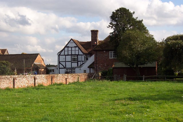
Fairlands Farm. Fairlands Farm, north of
Guildford, has had its surrounding fields turned into the Roker Park golf course. The farmhouse itself is an interesting example of a medieval building "done up" with a new Georgian front (not visible from this angle) in an 18th century attempt to keep up
891:
908:== {{int:filedesc}} == {{Information |description={{en|1=Fairlands Farm. Fairlands Farm, north of Guildford, has had its surrounding fields turned into the Roker Park golf course. The farmhouse itself is an interesting example of a medieval building "don
215:
43:
349:– You must give appropriate credit, provide a link to the license, and indicate if changes were made. You may do so in any reasonable manner, but not in any way that suggests the licensor endorses you or your use.
83:
415:
51:
398:
127:
with the latest fashion. A look round the back reveals the true state of affairs. Taken from the entrance to the golf course looking south-east.
751:
681:
645:
231:
771:
1101:
266:
993:
This file contains additional information, probably added from the digital camera or scanner used to create or digitize it.
356:
608:
822:
779:
735:
629:
601:
588:
573:
491:
1015:
794:
764:
701:
665:
546:
529:
438:
430:
253:
890:
885:
312:
42:
996:
If the file has been modified from its original state, some details may not fully reflect the modified file.
411:
1138:
1005:
355:– If you remix, transform, or build upon the material, you must distribute your contributions under the
273:
on the
Geograph website for the photographer's contact details. The copyright on this image is owned by
901:
309:
1174:
419:
91:
184:
1263:
404:
Remove redundant categories and try to put this image in the most specific category/categories
580:
168:
801:
786:
482:
486:
478:
474:
470:
466:
462:
458:
454:
450:
446:
237:
1226:
1156:
1120:
1022:
278:
78:
1273:
1236:
1051:
1184:
136:
922:
221:
157:
147:
1283:
1032:
258:
270:
858:
Click on a date/time to view the file as it appeared at that time.
223:
206:
66:
815:
216:
51° 15′ 57″ N, 0° 37′ 05″ W
513:
Add a one-line explanation of what this file represents
970:
960:
950:
940:
418:
combined with a database. You can also have a look at
410:
The location categories are based on information from
980:
110:
90:
Commons is a freely licensed media file repository.
682:
Creative
Commons Attribution-ShareAlike 2.0 Generic
56:(640 × 427 pixels, file size: 88 KB, MIME type:
395:The categories of this image should be checked.
366:https://creativecommons.org/licenses/by-sa/2.0
71:
372:Creative Commons Attribution-Share Alike 2.0
290:
8:
116:Fairlands Farm - geograph.org.uk - 57314.jpg
52:Fairlands_Farm_-_geograph.org.uk_-_57314.jpg
332:– to copy, distribute and transmit the work
998:
860:
509:
490:
933:The following other wikis use this file:
581:https://www.geograph.org.uk/profile/1811
1291:
1281:
1271:
1261:
1253:
1245:
1234:
1224:
1216:
1208:
1200:
1192:
1182:
1172:
1164:
1154:
1146:
1136:
1128:
1118:
1110:
1099:
1091:
1083:
1075:
1067:
1059:
1048:
1040:
1030:
1020:
1010:
920:
836:
820:
802:https://www.geograph.org.uk/photo/57314
749:
733:
715:
699:
679:
663:
643:
627:
560:
544:
527:
524:
505:
498:
437:This image was uploaded as part of the
209:
230:View this and other nearby images on:
1000:
425:The topic category from Geograph was
7:
277:and is licensed for reuse under the
918:The following page uses this file:
849:
313:Attribution-Share Alike 2.0 Generic
301:
296:
281:Attribution-ShareAlike 2.0 license.
991:
518:
512:
287:
264:
120:
103:
49:
517:
1042:Date and time of data generation
503:
388:
343:Under the following conditions:
308:This file is licensed under the
300:
295:
289:
257:
236:
222:
70:
31:
21:
500:
121:
46:No higher resolution available.
14:
752:file available on the internet
499:
265:This image was taken from the
26:
1:
1179:Flash did not fire, auto mode
823:coordinates of depicted place
36:
772:Geograph Britain and Ireland
602:object of statement has role
525:Items portrayed in this file
1112:Date and time of digitizing
1016:KODAK DX4330 DIGITAL CAMERA
1313:
1247:Focal length in 35 mm film
1205:One-chip color area sensor
977:Usage on www.wikidata.org
967:Usage on sv.wikipedia.org
957:Usage on pl.wikipedia.org
947:Usage on eu.wikipedia.org
937:Usage on es.wikipedia.org
357:same or compatible license
850:
16:
1115:16:00, 24 September 2005
1045:16:00, 24 September 2005
838:51°15'56.5"N, 0°37'4.8"W
780:geograph.org.uk image ID
502:
420:this tool from mysociety
386:
385:
323:
77:This is a file from the
1210:Custom image processing
907:
416:this OpenStreetMap tool
197:Ron Strutt /
178:Ron Strutt /
169:required by the license
153:
142:
135:
132:
113:
81:. Information from its
1293:Subject distance range
886:14:42, 30 January 2010
271:this photograph's page
242:51.265700; -0.618000
84:description page there
1148:Maximum land aperture
1069:Horizontal resolution
1006:EASTMAN KODAK COMPANY
439:Geograph batch upload
429:(find similar images
407:Remove this template
1085:Y and C positioning
1077:Vertical resolution
1002:Camera manufacturer
483:português do Brasil
338:– to adapt the work
1255:Scene capture type
1231:Auto white balance
589:author name string
412:this geonames tool
1300:
1299:
1151:3.7 APEX (f/3.61)
1027:1/250 sec (0.004)
929:Global file usage
911:
717:24 September 2005
666:copyright license
511:
494:
441:
286:
285:
269:collection. See
247:
246:
204:
203:
172:
137:24 September 2005
99:
98:
79:Wikimedia Commons
32:Global file usage
1304:
1093:Exposure Program
999:
898:
804:
799:
795:described at URL
789:
784:
774:
769:
630:copyright status
611:
606:
596:
593:
583:
578:
495:
436:
393:
392:
391:
379:
376:
373:
370:
367:
359:as the original.
321:
310:Creative Commons
304:
303:
299:
298:
293:
292:
279:Creative Commons
267:Geograph project
261:
254:
243:
240:
226:
225:
219:
218:
207:
166:
138:
125:
117:
111:
95:
74:
73:
67:
61:
59:
1312:
1311:
1307:
1306:
1305:
1303:
1302:
1301:
987:
927:
912:
904:
896:
852:
851:
848:
847:
846:
845:
844:
843:
842:
841:
839:
829:
828:
827:
825:
814:
813:
812:
811:
810:
809:
808:
807:
806:
805:
800:
797:
791:
790:
785:
782:
776:
775:
770:
767:
758:
757:
756:
754:
742:
741:
740:
738:
727:
726:
725:
724:
723:
722:
721:
720:
718:
708:
707:
706:
704:
693:
692:
691:
690:
689:
688:
687:
686:
684:
672:
671:
670:
668:
657:
656:
655:
654:
653:
652:
651:
650:
648:
636:
635:
634:
632:
621:
620:
619:
618:
617:
616:
615:
614:
613:
612:
607:
604:
598:
597:
594:
591:
585:
584:
579:
576:
567:
566:
565:
563:
553:
552:
551:
549:
538:
537:
536:
535:
534:
532:
516:
515:
514:
497:
445:
442:
399:Check them now!
389:
387:
381:
380:
377:
374:
371:
368:
365:
364:
322:
319:
316:
305:
282:
252:
241:
214:
213:
210:Object location
205:
194:
187:
175:
148:geograph.org.uk
128:
115:
108:
101:
100:
89:
88:
87:is shown below.
63:
57:
55:
48:
47:
12:
11:
5:
1310:
1308:
1298:
1297:
1294:
1290:
1289:
1286:
1280:
1279:
1276:
1270:
1269:
1266:
1260:
1259:
1256:
1252:
1251:
1248:
1244:
1243:
1240:
1233:
1232:
1229:
1223:
1222:
1219:
1215:
1214:
1213:Normal process
1211:
1207:
1206:
1203:
1202:Sensing method
1199:
1198:
1195:
1194:Exposure index
1191:
1190:
1187:
1181:
1180:
1177:
1171:
1170:
1167:
1163:
1162:
1159:
1153:
1152:
1149:
1145:
1144:
1141:
1135:
1134:
1131:
1127:
1126:
1123:
1117:
1116:
1113:
1109:
1108:
1105:
1098:
1097:
1096:Normal program
1094:
1090:
1089:
1086:
1082:
1081:
1078:
1074:
1073:
1070:
1066:
1065:
1062:
1058:
1057:
1054:
1047:
1046:
1043:
1039:
1038:
1035:
1029:
1028:
1025:
1019:
1018:
1013:
1009:
1008:
1003:
990:
986:
985:
984:
983:
975:
974:
973:
965:
964:
963:
955:
954:
953:
945:
944:
943:
931:
930:
926:
925:
916:
915:
910:
909:
906:
902:
899:
893:
888:
883:
879:
878:
875:
872:
869:
866:
863:
856:
855:
840:
837:
835:
834:
833:
832:
831:
830:
826:
821:
819:
818:
817:
816:
793:
792:
778:
777:
763:
762:
761:
760:
759:
755:
750:
748:
747:
746:
745:
744:
743:
739:
736:source of file
734:
732:
731:
730:
729:
728:
719:
716:
714:
713:
712:
711:
710:
709:
705:
700:
698:
697:
696:
695:
694:
685:
680:
678:
677:
676:
675:
674:
673:
669:
664:
662:
661:
660:
659:
658:
649:
644:
642:
641:
640:
639:
638:
637:
633:
628:
626:
625:
624:
623:
622:
600:
599:
587:
586:
572:
571:
570:
569:
568:
564:
561:
559:
558:
557:
556:
555:
554:
550:
545:
543:
542:
541:
540:
539:
533:
528:
526:
523:
522:
521:
520:
519:
508:
507:
504:
501:
435:
434:
423:
408:
405:
363:
362:
361:
360:
350:
341:
340:
339:
333:
326:You are free:
317:
307:
306:
288:
284:
283:
262:
251:
248:
245:
244:
234:
228:
211:
202:
201:
199:Fairlands Farm
195:
192:
189:
188:
183:
180:Fairlands Farm
176:
173:
161:
160:
155:
151:
150:
144:
140:
139:
134:
130:
129:
118:
109:
107:
104:
102:
97:
96:
75:
65:
64:
45:
41:
40:
39:
34:
29:
24:
19:
13:
10:
9:
6:
4:
3:
2:
1309:
1295:
1292:
1287:
1285:
1282:
1277:
1275:
1272:
1267:
1265:
1262:
1257:
1254:
1249:
1246:
1241:
1238:
1235:
1230:
1228:
1227:White balance
1225:
1221:Auto exposure
1220:
1218:Exposure mode
1217:
1212:
1209:
1204:
1201:
1196:
1193:
1188:
1186:
1183:
1178:
1176:
1173:
1168:
1165:
1160:
1158:
1157:Metering mode
1155:
1150:
1147:
1142:
1140:
1139:Exposure bias
1137:
1132:
1130:APEX aperture
1129:
1124:
1122:
1121:Shutter speed
1119:
1114:
1111:
1106:
1103:
1100:
1095:
1092:
1087:
1084:
1079:
1076:
1071:
1068:
1063:
1060:
1055:
1053:
1049:
1044:
1041:
1036:
1034:
1031:
1026:
1024:
1023:Exposure time
1021:
1017:
1014:
1011:
1007:
1004:
1001:
997:
994:
988:
982:
979:
978:
976:
972:
969:
968:
966:
962:
959:
958:
956:
952:
949:
948:
946:
942:
939:
938:
936:
935:
934:
928:
924:
921:
919:
913:
905:
900:
894:
892:
889:
887:
884:
881:
880:
876:
873:
870:
867:
864:
862:
861:
859:
853:
824:
803:
796:
788:
781:
773:
766:
753:
737:
703:
683:
667:
647:
631:
610:
603:
590:
582:
575:
548:
531:
496:
493:
488:
484:
480:
476:
472:
468:
464:
460:
456:
452:
448:
443:
440:
432:
428:
424:
421:
417:
413:
409:
406:
403:
402:
401:
400:
396:
384:
383:
369:CC BY-SA 2.0
358:
354:
351:
348:
345:
344:
342:
337:
334:
331:
328:
327:
325:
324:
318:Attribution:
314:
311:
294:
280:
276:
272:
268:
263:
260:
256:
255:
249:
239:
235:
233:
232:OpenStreetMap
229:
227:
217:
212:
208:
200:
196:
191:
190:
186:
182: /
181:
177:
170:
165:
163:
162:
159:
156:
152:
149:
145:
141:
131:
124:
119:
112:
105:
93:
86:
85:
80:
76:
69:
68:
62:
53:
44:
38:
35:
33:
30:
28:
25:
23:
20:
18:
15:
1237:Digital zoom
1166:Light source
1052:focal length
1012:Camera model
995:
992:
932:
917:
857:
854:File history
609:photographer
444:
426:
397:
394:
382:
352:
346:
335:
329:
274:
198:
185:CC BY-SA 2.0
179:
122:
92:You can help
82:
50:
22:File history
1185:Color space
1061:Orientation
903:GeographBot
646:copyrighted
431:at Geograph
353:share alike
347:attribution
164:Attribution
114:Description
1274:Saturation
914:File usage
895:640 × 427
871:Dimensions
595:Ron Strutt
562:some value
471:македонски
320:Ron Strutt
275:Ron Strutt
158:Ron Strutt
58:image/jpeg
27:File usage
1284:Sharpness
971:Fairlands
961:Fairlands
951:Fairlands
941:Fairlands
923:Fairlands
868:Thumbnail
865:Date/Time
702:inception
479:português
427:Farmhouse
250:Licensing
193:InfoField
174:InfoField
123:English:
1264:Contrast
1258:Standard
1088:Centered
1033:F-number
989:Metadata
981:Q5430512
765:operator
506:Captions
489: |
485: |
481: |
477: |
473: |
469: |
465: |
461: |
457: |
455:français
453: |
449: |
336:to remix
330:to share
315:license.
37:Metadata
1296:Unknown
1169:Unknown
1161:Average
1104:version
1080:230 dpi
1072:230 dpi
897:(88 KB)
882:current
877:Comment
547:creator
530:depicts
510:English
447:English
106:Summary
54:
1288:Normal
1278:Normal
1268:Normal
1064:Normal
487:Türkçe
475:മലയാളം
467:magyar
459:galego
220:
154:Author
143:Source
1250:76 mm
1239:ratio
1175:Flash
1056:16 mm
1050:Lens
1037:f/6.7
787:57314
463:עברית
451:suomi
146:From
1189:sRGB
1102:Exif
874:User
414:and
378:true
375:true
133:Date
17:File
1197:120
1133:5.5
1107:2.2
574:URL
492:+/−
798::
783::
768::
605::
592::
577::
1242:0
1143:0
1125:8
433:)
422:.
171:)
167:(
94:.
60:)
Text is available under the Creative Commons Attribution-ShareAlike License. Additional terms may apply.
_&language=en)
