232:
199:
43:
213:
238:
91:
595:
612:=={{int:filedesc}}== {{Information |description={{en|1=Ruins of the home of Fatenah and ‘Azzam Idris, Beit Hanina. There had been two apartments in the building: one was home to the 8-member Idris family and the other to their relative Mai who lived...
145:
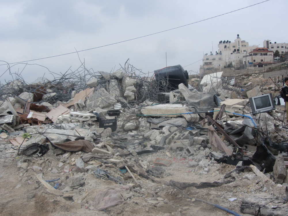
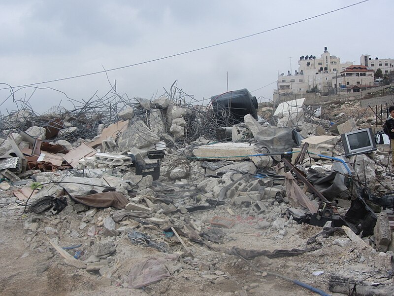
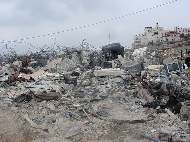
Ruins of the home of
Fatenah and ‘Azzam Idris, Beit Hanina. There had been two apartments in the building: one was home to the 8-member Idris family and the other to their relative Mai who lived there with her husband Baha a-Deb’i and their two minor
190:
279:– You must give appropriate credit, provide a link to the license, and indicate if changes were made. You may do so in any reasonable manner, but not in any way that suggests the licensor endorses you or your use.
57:
53:
47:
70:
102:
626:
594:
589:
61:
42:
472:
402:
366:
206:
834:
667:
This file contains additional information, probably added from the digital camera or scanner used to create or digitize it.
526:
456:
422:
350:
492:
386:
333:
654:
644:
689:
670:
If the file has been modified from its original state, some details may not fully reflect the modified file.
622:
The following pages on the
English Knowledge (XXG) use this file (pages on other projects are not listed):
900:
248:
245:
928:
165:
110:
605:
679:
212:
1012:
918:
882:
704:
97:
1022:
744:
946:
196:
155:
724:
714:
811:
784:
Beit Hanina demolition for the families Idriss and
Kisswani 3 houses
562:
Click on a date/time to view the file as it appeared at that time.
415:
198:
191:
31° 49′ 27.88″ N, 35° 13′ 11.57″ E
166:
http://www.btselem.org/photoblog/20140209_jerusalem_demolitions
181:
85:
175:'Amer 'Aruri, B'Tselem's field researcher in East Jerusalem
135:
Five demolitions in East
Jerusalem, January 2014 (5 2).jpg
645:
Demolición de viviendas en el conflicto israelí-palestino
317:
Add a one-line explanation of what this file represents
129:
109:
Commons is a freely licensed media file repository.
655:
Démolition des propriétés palestiniennes par Israël
75:(1,000 × 750 pixels, file size: 294 KB, MIME type:
933:Flash did not fire, compulsory flash suppression
403:Creative Commons Attribution 4.0 International
90:
231:
8:
286:https://creativecommons.org/licenses/by/4.0
262:– to copy, distribute and transmit the work
672:
627:Israeli demolition of Palestinian property
564:
313:
637:The following other wikis use this file:
1095:
1087:
1079:
1071:
1063:
1055:
1047:
1039:
1031:
1020:
1010:
1002:
994:
986:
978:
970:
962:
954:
944:
936:
926:
916:
908:
898:
890:
880:
872:
851:
843:
832:
824:
816:
806:
798:
790:
781:
776:
768:
760:
752:
741:
733:
722:
712:
702:
694:
684:
624:
540:
524:
506:
490:
470:
454:
436:
420:
400:
384:
364:
348:
331:
328:
309:
302:
184:
205:View this and other nearby images on:
674:
7:
553:
237:
665:
322:
316:
253:
228:
139:
122:
68:
321:
292:Creative Commons Attribution 4.0
1044:31ad474dcb16a592251386958fce0639
735:Date and time of data generation
423:coordinates of the point of view
307:
273:Under the following conditions:
244:This file is licensed under the
236:
230:
211:
197:
89:
31:
21:
304:
140:
14:
438:31°49'27.876"N, 35°13'11.572"E
303:
26:
1:
773:749.06 meters above sea level
249:Attribution 4.0 International
36:
329:Items portrayed in this file
972:Focal plane resolution unit
845:Date and time of digitizing
1117:
983:One-chip color area sensor
938:Supported Flashpix version
651:Usage on fr.wikipedia.org
641:Usage on es.wikipedia.org
1065:Geodetic survey data used
853:Meaning of each component
818:File change date and time
554:
16:
964:Focal plane Y resolution
956:Focal plane X resolution
690:Canon PowerShot SX230 HS
473:Canon PowerShot SX230 HS
306:
96:This is a file from the
1060:Measurement in progress
1049:GPS time (atomic clock)
996:Custom image processing
611:
171:
161:
154:
151:
132:
100:. Information from its
874:Image compression mode
848:11:42, 27 January 2014
821:16:48, 5 February 2014
738:11:42, 27 January 2014
217:31.824410; 35.219881
103:description page there
46:Size of this preview:
910:Maximum land aperture
792:Horizontal resolution
991:Digital still camera
590:13:41, 28 April 2014
826:Y and C positioning
800:Vertical resolution
709:1/800 sec (0.00125)
676:Camera manufacturer
268:– to adapt the work
52:Other resolutions:
1033:Scene capture type
1017:Auto white balance
62:1,000 × 750 pixels
1104:
1103:
1089:Rating (out of 5)
633:Global file usage
615:
387:copyright license
315:
222:
221:
179:
178:
118:
117:
98:Wikimedia Commons
32:Global file usage
1108:
967:16,393.442622951
959:16,393.442622951
785:
765:35° 13′ 11.57″ E
757:31° 49′ 27.88″ N
673:
602:
351:copyright status
299:
296:
293:
290:
287:
246:Creative Commons
240:
239:
234:
233:
218:
215:
201:
200:
194:
193:
182:
157:
144:
136:
130:
114:
93:
92:
86:
80:
78:
65:
58:640 × 480 pixels
54:320 × 240 pixels
48:800 × 600 pixels
1116:
1115:
1111:
1110:
1109:
1107:
1106:
1105:
1081:GPS tag version
1076:27 January 2014
1057:Receiver status
1041:Unique image ID
783:
661:
631:
623:
616:
608:
600:
556:
555:
552:
551:
550:
549:
548:
547:
546:
545:
543:
533:
532:
531:
529:
518:
517:
516:
515:
514:
513:
512:
511:
509:
508:27 January 2014
499:
498:
497:
495:
484:
483:
482:
481:
480:
479:
478:
477:
475:
463:
462:
461:
459:
448:
447:
446:
445:
444:
443:
442:
441:
439:
429:
428:
427:
425:
414:
413:
412:
411:
410:
409:
408:
407:
405:
393:
392:
391:
389:
378:
377:
376:
375:
374:
373:
372:
371:
369:
357:
356:
355:
353:
342:
341:
340:
339:
338:
336:
320:
319:
318:
301:
300:
297:
294:
291:
288:
285:
284:
252:
241:
227:
216:
189:
188:
185:Camera location
180:
156:27 January 2014
147:
134:
127:
120:
119:
108:
107:
106:is shown below.
82:
76:
74:
67:
66:
51:
12:
11:
5:
1114:
1112:
1102:
1101:
1098:
1094:
1093:
1090:
1086:
1085:
1082:
1078:
1077:
1074:
1070:
1069:
1066:
1062:
1061:
1058:
1054:
1053:
1050:
1046:
1045:
1042:
1038:
1037:
1034:
1030:
1029:
1026:
1019:
1018:
1015:
1009:
1008:
1005:
1001:
1000:
999:Normal process
997:
993:
992:
989:
985:
984:
981:
980:Sensing method
977:
976:
973:
969:
968:
965:
961:
960:
957:
953:
952:
949:
943:
942:
939:
935:
934:
931:
925:
924:
921:
915:
914:
911:
907:
906:
903:
897:
896:
893:
889:
888:
885:
879:
878:
875:
871:
870:
869:
868:
867:does not exist
865:
862:
859:
854:
850:
849:
846:
842:
841:
838:
831:
830:
827:
823:
822:
819:
815:
814:
809:
805:
804:
801:
797:
796:
793:
789:
788:
787:
786:
779:
775:
774:
771:
767:
766:
763:
759:
758:
755:
751:
750:
747:
740:
739:
736:
732:
731:
728:
721:
720:
717:
711:
710:
707:
701:
700:
697:
693:
692:
687:
683:
682:
677:
664:
660:
659:
658:
657:
649:
648:
647:
635:
634:
630:
629:
621:
620:
619:
614:
613:
610:
606:
603:
597:
592:
587:
583:
582:
579:
576:
573:
570:
567:
560:
559:
544:
541:
539:
538:
537:
536:
535:
534:
530:
525:
523:
522:
521:
520:
519:
510:
507:
505:
504:
503:
502:
501:
500:
496:
491:
489:
488:
487:
486:
485:
476:
471:
469:
468:
467:
466:
465:
464:
460:
455:
453:
452:
451:
450:
449:
440:
437:
435:
434:
433:
432:
431:
430:
426:
421:
419:
418:
417:
416:
406:
401:
399:
398:
397:
396:
395:
394:
390:
385:
383:
382:
381:
380:
379:
370:
365:
363:
362:
361:
360:
359:
358:
354:
349:
347:
346:
345:
344:
343:
337:
332:
330:
327:
326:
325:
324:
323:
312:
311:
308:
305:
283:
282:
281:
280:
271:
270:
269:
263:
256:You are free:
243:
242:
229:
226:
223:
220:
219:
209:
203:
186:
177:
176:
173:
169:
168:
163:
159:
158:
153:
149:
148:
137:
128:
126:
123:
121:
116:
115:
94:
84:
83:
45:
41:
40:
39:
34:
29:
24:
19:
13:
10:
9:
6:
4:
3:
2:
1113:
1099:
1096:
1091:
1088:
1083:
1080:
1075:
1072:
1067:
1064:
1059:
1056:
1051:
1048:
1043:
1040:
1035:
1032:
1027:
1024:
1021:
1016:
1014:
1013:White balance
1011:
1007:Auto exposure
1006:
1004:Exposure mode
1003:
998:
995:
990:
987:
982:
979:
974:
971:
966:
963:
958:
955:
950:
948:
945:
940:
937:
932:
930:
927:
922:
920:
919:Metering mode
917:
912:
909:
904:
902:
901:Exposure bias
899:
894:
892:APEX aperture
891:
886:
884:
883:Shutter speed
881:
876:
873:
866:
863:
860:
857:
856:
855:
852:
847:
844:
839:
836:
833:
828:
825:
820:
817:
813:
810:
808:Software used
807:
802:
799:
794:
791:
782:
780:
777:
772:
769:
764:
761:
756:
753:
748:
746:
742:
737:
734:
729:
726:
723:
718:
716:
713:
708:
706:
705:Exposure time
703:
698:
695:
691:
688:
685:
681:
678:
675:
671:
668:
662:
656:
653:
652:
650:
646:
643:
642:
640:
639:
638:
632:
628:
625:
617:
609:
604:
598:
596:
593:
591:
588:
585:
584:
580:
577:
574:
571:
568:
566:
565:
563:
557:
528:
494:
474:
458:
457:captured with
424:
404:
388:
368:
352:
335:
278:
275:
274:
272:
267:
264:
261:
258:
257:
255:
254:
250:
247:
235:
224:
214:
210:
208:
207:OpenStreetMap
204:
202:
192:
187:
183:
174:
170:
167:
164:
160:
150:
143:
138:
131:
124:
112:
105:
104:
99:
95:
88:
87:
81:
72:
71:Original file
63:
59:
55:
49:
44:
38:
35:
33:
30:
28:
25:
23:
20:
18:
15:
1023:Digital zoom
913:4 APEX (f/4)
745:focal length
686:Camera model
669:
666:
636:
607:Sean.hoyland
599:1,000 × 750
561:
558:File history
276:
265:
259:
141:
111:You can help
101:
69:
22:File history
1097:IIM version
988:File source
947:Color space
778:Image title
367:copyrighted
277:attribution
133:Description
618:File usage
575:Dimensions
542:image/jpeg
527:media type
289:CC BY 4.0
77:image/jpeg
27:File usage
762:Longitude
725:ISO speed
572:Thumbnail
569:Date/Time
493:inception
225:Licensing
146:children.
142:English:
1073:GPS date
1036:Standard
829:Co-sited
770:Altitude
754:Latitude
749:8.812 mm
715:F-number
663:Metadata
601:(294 KB)
310:Captions
266:to remix
260:to share
251:license.
37:Metadata
1084:0.0.3.2
923:Pattern
887:9.65625
837:version
803:180 dpi
795:180 dpi
586:current
581:Comment
334:depicts
314:English
125:Summary
73:
1068:WGS-84
975:inches
812:Picasa
727:rating
699:Picasa
696:Author
195:
172:Author
162:Source
1052:09:45
1025:ratio
929:Flash
743:Lens
680:Canon
951:sRGB
835:Exif
578:User
298:true
295:true
152:Date
17:File
840:2.3
730:100
719:f/4
864:Cr
861:Cb
60:|
56:|
50:.
1100:4
1092:0
1028:1
941:1
905:0
895:4
877:3
858:Y
113:.
79:)
64:.
Text is available under the Creative Commons Attribution-ShareAlike License. Additional terms may apply.
.jpg)
.jpg¶ms=031.824410_N_0035.219881_E_globe:Earth_type:camera_alt:749.06_source:exif_&language=en)