38:
236:
322:
242:
98:
566:
173:
Satellite image map of
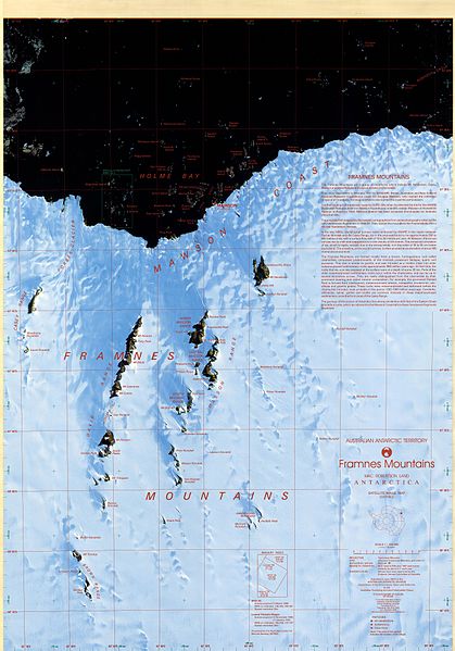
Framnes Mountains, Mac. Robertson Land, Antarctica. This map was produced for the Australian Antarctic Division by AUSLIG (now Geoscience Australia) Commercial, in Australia, in 1997. The map is at a scale of 1:100000, and was produced from SPOT XS (WRS 246-491, 246-490) and
174:
Landsat TM (WRS 137-107, 135-108) scenes. It is projected on a
Transverse Mercator projection, and shows glaciers/ice shelves, stations/bases, refuges/depots, specially protected areas (SPA), and gives some historical text information. The map has both geographical and UTM co-ordinates.
536:
583:=={{int:filedesc}}== {{Information |description={{en|1=Satellite image map of Framnes Mountains, Mac. Robertson Land, Antarctica. This map was produced for the Australian Antarctic Division by AUSLIG (now Geoscience Australia) Commercial, in Australia,...
293:– You must give appropriate credit, provide a link to the license, and indicate if changes were made. You may do so in any reasonable manner, but not in any way that suggests the licensor endorses you or your use.
64:
60:
56:
52:
48:
42:
109:
77:
685:
212:
142:
The original file is very high-resolution. It might not load properly or could cause your browser to freeze when opened at full size.
565:
560:
260:
Brolsma, H. (1999, updated 2014) Framnes
Mountains Satellite Image Map 1:100000 Australian Antarctic Data Centre - CAASM Metadata (
447:
411:
395:
146:
467:
431:
378:
535:
530:
333:
68:
37:
593:
The following pages on the
English Knowledge (XXG) use this file (pages on other projects are not listed):
546:
252:
249:
690:
117:
329:
193:
680:
612:
635:
261:
219:
104:
341:, who confirmed that it was available there under the stated license on that date.
337:
607:
602:
597:
183:
617:
576:
503:
Click on a date/time to view the file as it appeared at that time.
645:
660:
135:
92:
670:
705:
82:(8,256 × 11,808 pixels, file size: 18.35 MB, MIME type:
650:
362:
Add a one-line explanation of what this file represents
700:
720:
715:
316:
262:
https://data.aad.gov.au/metadata/records/framnes_sat
157:
116:
Commons is a freely licensed media file repository.
97:
235:
8:
300:https://creativecommons.org/licenses/by/3.0
276:– to copy, distribute and transmit the work
505:
358:
328:This file, which was originally posted to
628:The following other wikis use this file:
448:Creative Commons Attribution 3.0 Unported
203:Australian Antarctic Division (Australia)
163:Framnes Mountains Satellite Image Map.jpg
595:
481:
465:
445:
429:
409:
393:
376:
373:
354:
347:
138:
332:, was reviewed on 13 January 2017 by
330:Framnes Mountains, Mac.Robertson Land
194:Framnes Mountains, Mac.Robertson Land
7:
494:
241:
367:
361:
327:
267:
232:
167:
129:
75:
366:
306:Creative Commons Attribution 3.0
352:
320:
287:Under the following conditions:
248:This file is licensed under the
240:
234:
96:
31:
21:
349:
168:
14:
348:
26:
1:
374:Items portrayed in this file
642:Usage on ceb.wikipedia.org
739:
712:Usage on www.wikidata.org
697:Usage on nn.wikipedia.org
677:Usage on he.wikipedia.org
667:Usage on es.wikipedia.org
657:Usage on de.wikipedia.org
632:Usage on bg.wikipedia.org
553:Bot: Image rotated by 180°
495:
16:
351:
253:Attribution 3.0 Unported
103:This is a file from the
582:
552:
207:
199:
189:
182:
179:
160:
107:. Information from its
110:description page there
41:Size of this preview:
686:תבנית:איים במפרץ הולם
561:14:47, 6 January 2017
531:16:03, 6 January 2017
69:8,256 × 11,808 pixels
65:1,432 × 2,048 pixels
282:– to adapt the work
47:Other resolutions:
148:Open in ZoomViewer
61:716 × 1,024 pixels
661:Framnes Mountains
646:Framnes Mountains
624:Global file usage
613:Framnes Mountains
586:
432:copyright license
360:
346:
345:
225:
224:
216:
213:Reusing this file
155:
154:
125:
124:
105:Wikimedia Commons
32:Global file usage
730:
573:
548:SteinsplitterBot
543:
396:copyright status
324:
323:
317:
313:
310:
307:
304:
301:
265:
250:Creative Commons
244:
243:
238:
237:
220:Metadata details
210:
185:
172:
164:
158:
151:
149:
136:
121:
100:
99:
93:
87:
85:
72:
57:537 × 768 pixels
53:335 × 480 pixels
49:168 × 240 pixels
43:419 × 599 pixels
738:
737:
733:
732:
731:
729:
728:
727:
622:
594:
587:
579:
571:
570:8,268 × 11,812
549:
541:
540:8,256 × 11,808
497:
496:
493:
492:
491:
490:
489:
488:
487:
486:
484:
474:
473:
472:
470:
459:
458:
457:
456:
455:
454:
453:
452:
450:
438:
437:
436:
434:
423:
422:
421:
420:
419:
418:
417:
416:
414:
402:
401:
400:
398:
387:
386:
385:
384:
383:
381:
365:
364:
363:
342:
321:
315:
314:
311:
308:
305:
302:
299:
298:
266:
259:
256:
245:
231:
226:
175:
162:
147:
145:
134:
127:
126:
115:
114:
113:is shown below.
89:
83:
81:
74:
73:
46:
12:
11:
5:
736:
734:
726:
725:
724:
723:
718:
710:
709:
708:
703:
695:
694:
693:
688:
683:
675:
674:
673:
665:
664:
663:
655:
654:
653:
648:
640:
639:
638:
626:
625:
621:
620:
615:
610:
605:
600:
592:
591:
590:
585:
584:
581:
577:
574:
568:
563:
558:
555:
554:
551:
547:
544:
538:
533:
528:
524:
523:
520:
517:
514:
511:
508:
501:
500:
485:
483:6 January 2017
482:
480:
479:
478:
477:
476:
475:
471:
466:
464:
463:
462:
461:
460:
451:
446:
444:
443:
442:
441:
440:
439:
435:
430:
428:
427:
426:
425:
424:
415:
410:
408:
407:
406:
405:
404:
403:
399:
394:
392:
391:
390:
389:
388:
382:
377:
375:
372:
371:
370:
369:
368:
357:
356:
353:
350:
344:
343:
325:
297:
296:
295:
294:
285:
284:
283:
277:
270:You are free:
257:
247:
246:
233:
230:
227:
223:
222:
217:
205:
204:
201:
197:
196:
191:
187:
186:
184:6 January 2017
181:
177:
176:
165:
156:
153:
152:
143:
140:
133:
130:
128:
123:
122:
101:
91:
90:
40:
36:
35:
34:
29:
24:
19:
13:
10:
9:
6:
4:
3:
2:
735:
722:
719:
717:
714:
713:
711:
707:
706:Framnesfjella
704:
702:
699:
698:
696:
692:
689:
687:
684:
682:
679:
678:
676:
672:
669:
668:
666:
662:
659:
658:
656:
652:
649:
647:
644:
643:
641:
637:
634:
633:
631:
630:
629:
623:
619:
616:
614:
611:
609:
606:
604:
601:
599:
596:
588:
580:
575:
569:
567:
564:
562:
559:
557:
556:
550:
545:
539:
537:
534:
532:
529:
526:
525:
521:
518:
515:
512:
509:
507:
506:
504:
498:
469:
449:
433:
413:
397:
380:
340:
339:
335:
331:
326:
319:
318:
292:
289:
288:
286:
281:
278:
275:
272:
271:
269:
268:
263:
258:Attribution:
254:
251:
239:
228:
221:
218:
214:
209:
206:
202:
198:
195:
192:
188:
178:
171:
166:
159:
150:
144:
141:
137:
131:
119:
112:
111:
106:
102:
95:
94:
88:
79:
78:Original file
70:
66:
62:
58:
54:
50:
44:
39:
33:
30:
28:
25:
23:
20:
18:
15:
627:
502:
499:File history
336:
290:
279:
273:
169:
118:You can help
108:
76:
22:File history
671:Bahía Holme
608:David Range
603:Casey Range
598:Brown Range
412:copyrighted
291:attribution
161:Description
691:הרי פראמנס
589:File usage
572:(18.36 MB)
542:(18.35 MB)
516:Dimensions
303:CC BY 3.0
208:Permission
84:image/jpeg
27:File usage
701:Holmevika
681:מפרץ הולם
651:Holmevika
618:Holme Bay
513:Thumbnail
510:Date/Time
468:inception
338:INeverCry
229:Licensing
170:English:
721:Q5256660
355:Captions
334:reviewer
280:to remix
274:to share
255:license.
139:Warning
716:Q281813
636:Фрамнес
527:current
522:Comment
379:depicts
359:English
132:Summary
80:
200:Author
190:Source
578:4ing
519:User
312:true
309:true
180:Date
17:File
67:|
63:|
59:|
55:|
51:|
45:.
264:)
215:)
211:(
120:.
86:)
71:.
Text is available under the Creative Commons Attribution-ShareAlike License. Additional terms may apply.
