348:
281:
231:
273:
223:
447:
295:
245:
316:
354:
359:
72:
940:"}},"text\/plain":{"en":{"":"heading"}}},"{\"value\":{\"amount\":\"+225\",\"unit\":\"http:\\\/\\\/www.wikidata.org\\\/entity\\\/Q28390\"},\"type\":\"quantity\"}":{"text\/html":{"en":{"P7787":"225
876:"}},"text\/plain":{"en":{"":"heading"}}},"{\"value\":{\"amount\":\"+225\",\"unit\":\"http:\\\/\\\/www.wikidata.org\\\/entity\\\/Q28390\"},\"type\":\"quantity\"}":{"text\/html":{"en":{"P7787":"225
936:
264:
214:
43:
406:– You must give appropriate credit, provide a link to the license, and indicate if changes were made. You may do so in any reasonable manner, but not in any way that suggests the licensor endorses you or your use.
1059:== {{int:filedesc}} == {{Information |description={{en|1=Froxfield Bottom Lock No 70 Seen from the east as in 1976, restored but not yet in use.}} |date=1976-03-27 |source=From |author=[http://www.
83:
51:
455:
937:
873:
472:
774:
738:
702:
288:
238:
809:
323:
1104:
This file contains additional information, probably added from the digital camera or scanner used to create or digitize it.
1041:
1036:
42:
413:
665:
1140:
978:
951:
914:
887:
817:
758:
686:
658:
645:
630:
548:
845:
802:
787:
722:
603:
586:
495:
310:
487:
369:
1107:
If the file has been modified from its original state, some details may not fully reflect the modified file.
468:
1073:
412:– If you remix, transform, or build upon the material, you must distribute your contributions under the
330:
on the
Geograph website for the photographer's contact details. The copyright on this image is owned by
1052:
366:
944:"}},"text\/plain":{"en":{"P7787":"225 degree"}}}}": -->
880:"}},"text\/plain":{"en":{"P7787":"225 degree"}}}}": -->
476:
91:
183:
461:
Remove redundant categories and try to put this image in the most specific category/categories
824:
794:
167:
637:
539:
543:
535:
531:
527:
523:
519:
515:
511:
507:
503:
294:
244:
126:
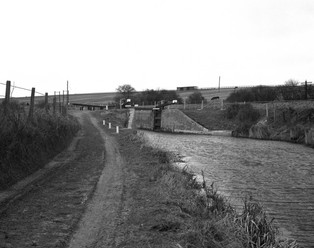
Froxfield Bottom Lock No 70 Seen from the east as in 1976, restored but not yet in use.
335:
78:
1155:
135:
278:
228:
1091:
146:
156:
315:
327:
1009:
Click on a date/time to view the file as it appeared at that time.
280:
230:
255:
205:
66:
116:
Froxfield Bottom Lock No 70 - geograph.org.uk - 408740.jpg
52:
Froxfield_Bottom_Lock_No_70_-_geograph.org.uk_-_408740.jpg
265:
51° 24′ 27″ N, 1° 33′ 53″ W
215:
51° 24′ 29″ N, 1° 33′ 47″ W
570:
Add a one-line explanation of what this file represents
475:
combined with a database. You can also have a look at
467:
The location categories are based on information from
110:
90:
Commons is a freely licensed media file repository.
739:
Creative
Commons Attribution-ShareAlike 2.0 Generic
56:(640 × 505 pixels, file size: 91 KB, MIME type:
452:The categories of this image should be checked.
423:https://creativecommons.org/licenses/by-sa/2.0
71:
429:Creative Commons Attribution-Share Alike 2.0
347:
8:
941:
877:
389:– to copy, distribute and transmit the work
1109:
1011:
566:
547:
1084:The following other wikis use this file:
795:https://www.geograph.org.uk/photo/408740
1153:
1145:
1135:
1127:
1119:
1111:
1071:
965:
949:
901:
885:
859:
843:
772:
756:
736:
720:
700:
684:
638:https://www.geograph.org.uk/profile/796
617:
601:
584:
581:
562:
555:
494:This image was uploaded as part of the
258:
208:
287:View this and other nearby images on:
237:View this and other nearby images on:
482:The topic category from Geograph was
7:
334:and is licensed for reuse under the
1069:The following page uses this file:
1000:
370:Attribution-Share Alike 2.0 Generic
358:
353:
338:Attribution-ShareAlike 2.0 license.
1102:
575:
569:
344:
321:
120:
103:
49:
574:
888:coordinates of the point of view
560:
445:
400:Under the following conditions:
365:This file is licensed under the
357:
352:
346:
314:
293:
279:
271:
243:
229:
221:
70:
31:
21:
557:
121:
46:No higher resolution available.
14:
775:file available on the internet
556:
322:This image was taken from the
26:
1:
952:coordinates of depicted place
36:
1141:Adobe Photoshop Elements 2.0
810:Geograph Britain and Ireland
659:object of statement has role
582:Items portrayed in this file
270:
220:
196:Dr Neil Clifton /
177:Dr Neil Clifton /
967:51°24'26.57"N, 1°33'52.92"W
198:Froxfield Bottom Lock No 70
179:Froxfield Bottom Lock No 70
1177:
1092:Écluse de Froxfield Bottom
1088:Usage on fr.wikipedia.org
414:same or compatible license
1147:File change date and time
1001:
903:51°24'29.2"N, 1°33'47.2"W
16:
818:geograph.org.uk image ID
559:
477:this tool from mysociety
443:
442:
380:
77:This is a file from the
1058:
473:this OpenStreetMap tool
168:required by the license
152:
141:
134:
131:
113:
81:. Information from its
1150:16:59, 6 November 2006
1037:21:38, 3 February 2011
328:this photograph's page
299:51.407380; -1.564700
249:51.408100; -1.563100
84:description page there
1121:Horizontal resolution
1074:Froxfield Bottom Lock
496:Geograph batch upload
486:(find similar images
464:Remove this template
1129:Vertical resolution
540:português do Brasil
395:– to adapt the work
646:author name string
469:this geonames tool
1164:
1163:
1080:Global file usage
1062:
943:
879:
723:copyright license
568:
551:
498:
343:
342:
326:collection. See
304:
303:
254:
253:
203:
202:
171:
99:
98:
79:Wikimedia Commons
32:Global file usage
1168:
1110:
1049:
989:
988:
983:
925:
924:
919:
827:
822:
812:
807:
797:
792:
788:described at URL
687:copyright status
668:
663:
653:
650:
640:
635:
552:
493:
450:
449:
448:
436:
433:
430:
427:
424:
416:as the original.
378:
367:Creative Commons
361:
360:
356:
355:
350:
349:
336:Creative Commons
324:Geograph project
318:
311:
300:
297:
283:
282:
276:
275:
274:
268:
267:
256:
250:
247:
233:
232:
226:
225:
224:
218:
217:
206:
165:
137:
125:
117:
111:
95:
74:
73:
67:
61:
59:
1176:
1175:
1171:
1170:
1169:
1167:
1166:
1165:
1098:
1078:
1063:
1055:
1047:
1003:
1002:
999:
998:
997:
996:
995:
994:
993:
992:
991:
990:
986:
984:
981:
972:
971:
970:
968:
958:
957:
956:
954:
935:
934:
933:
932:
931:
930:
929:
928:
927:
926:
922:
920:
917:
908:
907:
906:
904:
894:
893:
892:
890:
871:
870:
869:
868:
867:
866:
865:
864:
862:
852:
851:
850:
848:
837:
836:
835:
834:
833:
832:
831:
830:
829:
828:
823:
820:
814:
813:
808:
805:
799:
798:
793:
790:
781:
780:
779:
777:
765:
764:
763:
761:
750:
749:
748:
747:
746:
745:
744:
743:
741:
729:
728:
727:
725:
714:
713:
712:
711:
710:
709:
708:
707:
705:
693:
692:
691:
689:
678:
677:
676:
675:
674:
673:
672:
671:
670:
669:
664:
661:
655:
654:
652:Dr Neil Clifton
651:
648:
642:
641:
636:
633:
624:
623:
622:
620:
610:
609:
608:
606:
595:
594:
593:
592:
591:
589:
573:
572:
571:
554:
502:
499:
456:Check them now!
446:
444:
438:
437:
434:
431:
428:
425:
422:
421:
379:
377:Dr Neil Clifton
376:
373:
362:
339:
332:Dr Neil Clifton
309:
298:
272:
263:
262:
259:Object location
248:
222:
213:
212:
209:Camera location
204:
193:
186:
174:
157:Dr Neil Clifton
147:geograph.org.uk
127:
115:
108:
101:
100:
89:
88:
87:is shown below.
63:
57:
55:
48:
47:
12:
11:
5:
1174:
1172:
1162:
1161:
1158:
1152:
1151:
1148:
1144:
1143:
1138:
1134:
1133:
1130:
1126:
1125:
1122:
1118:
1117:
1114:
1101:
1097:
1096:
1095:
1094:
1082:
1081:
1077:
1076:
1067:
1066:
1061:
1060:
1057:
1053:
1050:
1044:
1039:
1034:
1030:
1029:
1026:
1023:
1020:
1017:
1014:
1007:
1006:
977:
976:
975:
974:
973:
969:
966:
964:
963:
962:
961:
960:
959:
955:
950:
948:
947:
946:
945:
939:
913:
912:
911:
910:
909:
905:
902:
900:
899:
898:
897:
896:
895:
891:
886:
884:
883:
882:
881:
875:
863:
860:
858:
857:
856:
855:
854:
853:
849:
844:
842:
841:
840:
839:
838:
816:
815:
801:
800:
786:
785:
784:
783:
782:
778:
773:
771:
770:
769:
768:
767:
766:
762:
759:source of file
757:
755:
754:
753:
752:
751:
742:
737:
735:
734:
733:
732:
731:
730:
726:
721:
719:
718:
717:
716:
715:
706:
701:
699:
698:
697:
696:
695:
694:
690:
685:
683:
682:
681:
680:
679:
657:
656:
644:
643:
629:
628:
627:
626:
625:
621:
618:
616:
615:
614:
613:
612:
611:
607:
602:
600:
599:
598:
597:
596:
590:
585:
583:
580:
579:
578:
577:
576:
565:
564:
561:
558:
492:
491:
480:
465:
462:
420:
419:
418:
417:
407:
398:
397:
396:
390:
383:You are free:
374:
364:
363:
345:
341:
340:
319:
308:
305:
302:
301:
291:
285:
260:
252:
251:
241:
235:
210:
201:
200:
194:
191:
188:
187:
182:
175:
172:
160:
159:
154:
150:
149:
143:
139:
138:
133:
129:
128:
118:
109:
107:
104:
102:
97:
96:
75:
65:
64:
45:
41:
40:
39:
34:
29:
24:
19:
13:
10:
9:
6:
4:
3:
2:
1173:
1159:
1157:
1154:
1149:
1146:
1142:
1139:
1137:Software used
1136:
1131:
1128:
1123:
1120:
1115:
1112:
1108:
1105:
1099:
1093:
1090:
1089:
1087:
1086:
1085:
1079:
1075:
1072:
1070:
1064:
1056:
1051:
1045:
1043:
1040:
1038:
1035:
1032:
1031:
1027:
1024:
1021:
1018:
1015:
1013:
1012:
1010:
1004:
980:
953:
916:
889:
861:27 March 1976
847:
826:
819:
811:
804:
796:
789:
776:
760:
740:
724:
704:
688:
667:
660:
647:
639:
632:
605:
588:
553:
550:
545:
541:
537:
533:
529:
525:
521:
517:
513:
509:
505:
500:
497:
489:
485:
481:
478:
474:
470:
466:
463:
460:
459:
458:
457:
453:
441:
440:
426:CC BY-SA 2.0
415:
411:
408:
405:
402:
401:
399:
394:
391:
388:
385:
384:
382:
381:
375:Attribution:
371:
368:
351:
337:
333:
329:
325:
320:
317:
313:
312:
306:
296:
292:
290:
289:OpenStreetMap
286:
284:
266:
261:
257:
246:
242:
240:
239:OpenStreetMap
236:
234:
216:
211:
207:
199:
195:
190:
189:
185:
181: /
180:
176:
169:
164:
162:
161:
158:
155:
151:
148:
144:
140:
136:27 March 1976
130:
124:
119:
112:
105:
93:
86:
85:
80:
76:
69:
68:
62:
53:
44:
38:
35:
33:
30:
28:
25:
23:
20:
18:
15:
1160:Uncalibrated
1106:
1103:
1083:
1068:
1008:
1005:File history
666:photographer
501:
483:
454:
451:
439:
409:
403:
392:
386:
331:
269:
219:
197:
184:CC BY-SA 2.0
178:
122:
92:You can help
82:
50:
22:File history
1156:Color space
1113:Orientation
1054:GeographBot
703:copyrighted
488:at Geograph
410:share alike
404:attribution
163:Attribution
114:Description
1065:File usage
1046:640 × 505
1022:Dimensions
619:some value
528:македонски
58:image/jpeg
27:File usage
1132:1,800 dpi
1124:1,800 dpi
1019:Thumbnail
1016:Date/Time
846:inception
536:português
307:Licensing
192:InfoField
173:InfoField
123:English:
1100:Metadata
803:operator
563:Captions
546: |
542: |
538: |
534: |
530: |
526: |
522: |
518: |
514: |
512:français
510: |
506: |
393:to remix
387:to share
372:license.
37:Metadata
1048:(91 KB)
1033:current
1028:Comment
979:heading
938:heading
915:heading
874:heading
604:creator
587:depicts
567:English
504:English
106:Summary
54:
1116:Normal
987:degree
942:degree
923:degree
878:degree
825:408740
544:Türkçe
532:മലയാളം
524:magyar
516:galego
277:
227:
153:Author
142:Source
520:עברית
508:suomi
145:From
1025:User
985:225
921:225
484:Lock
471:and
435:true
432:true
132:Date
17:File
631:URL
549:+/−
982::
918::
821::
806::
791::
662::
649::
634::
490:)
479:.
170:)
166:(
94:.
60:)
Text is available under the Creative Commons Attribution-ShareAlike License. Additional terms may apply.
_heading:225.00&language=en)
_heading:225.00&language=en)
