38:
199:
205:
210:
94:
553:
523:
493:
463:
251:– You must give appropriate credit, provide a link to the license, and indicate if changes were made. You may do so in any reasonable manner, but not in any way that suggests the licensor endorses you or your use.
930:
68:
64:
60:
56:
52:
48:
42:
77:
105:
643:
633:
638:
552:
547:
522:
517:
492:
487:
570:{{OpenStreetMap|name=Fuerteventura|source=http://www.openstreetmap.org/?lat=28.4165&lon=-14.1515&zoom=10&layers=B000FTFTT}}
571:
183:
408:
372:
666:
258:
618:
608:
577:
356:
392:
339:
861:
623:
462:
457:
37:
574:
613:
220:
681:
661:
598:
676:
593:
257:– If you remix, transform, or build upon the material, you must distribute your contributions under the
856:
628:
217:
771:
603:
563:
533:
503:
473:
113:
851:
144:
This map may be incomplete, and may contain errors. Don't rely solely on it for navigation.
191:
100:
292:
139:
721:
846:
906:
891:
886:
876:
786:
741:
901:
756:
706:
701:
866:
746:
816:
776:
711:
127:
731:
430:
Click on a date/time to view the file as it appeared at that time.
896:
881:
696:
162:
821:
766:
691:
761:
88:
82:(SVG file, nominally 2,298 × 2,648 pixels, file size: 2.01 MB)
751:
911:
836:
921:
916:
862:
Wikipédia:Atelier modèle de géolocalisation/Archives/2015
871:
841:
806:
826:
791:
736:
323:
Add a one-line explanation of what this file represents
301:
If inappropriate please set warp_status = skip to hide.
831:
857:
Wikipédia:Atelier graphique/Cartes/Archives/juin 2015
811:
801:
682:
Módulu:Mapa de llocalización/datos/Fuerteventura/usu
112:
Commons is a freely licensed media file repository.
726:
409:
Creative
Commons Attribution-ShareAlike 2.0 Generic
194:Attribution-ShareAlike 2.0 license (CC-BY-SA 2.0).
190:OpenStreetMap data and maps are licensed under the
781:
716:
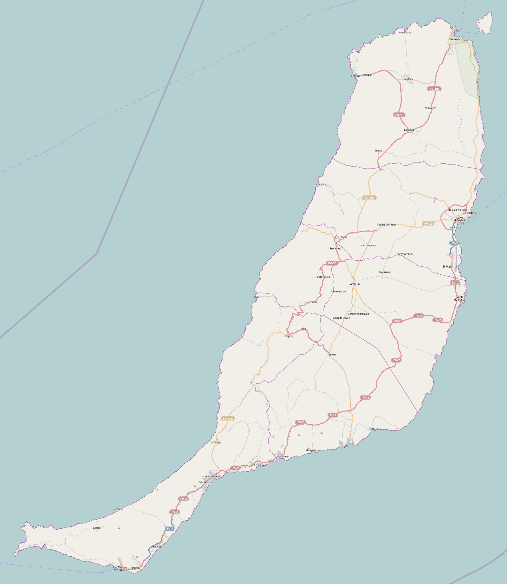
572:Category:OpenStreetMap maps of the Canary Islands
677:Módulu:Mapa de llocalización/datos/Fuerteventura
644:Module:Location map/data/Spain Fuerteventura/doc
772:Plantilla:Mapa de localización de Fuerteventura
133:Fuerteventura (Canary Islands) - OSM Mapnik.svg
667:وحدة:Location map/data/Spain Fuerteventura/شرح
634:Template:Lighthouses of the Canary Islands map
268:https://creativecommons.org/licenses/by-sa/2.0
93:
274:Creative Commons Attribution-Share Alike 2.0
198:
8:
639:Module:Location map/data/Spain Fuerteventura
234:– to copy, distribute and transmit the work
41:Size of this PNG preview of this SVG file:
662:وحدة:Location map/data/Spain Fuerteventura
432:
319:
142:project data, collected by the community.
654:The following other wikis use this file:
591:
406:
390:
370:
354:
337:
334:
315:
308:
295:Georeference the map in Wikimaps Warper
589:The following 11 pages use this file:
7:
852:Modèle:Géolocalisation/Fuerteventura
578:Category:Maps of the Canary Islands
421:
221:Attribution-Share Alike 2.0 Generic
209:
204:
328:
322:
195:
125:
75:
327:
313:
245:Under the following conditions:
216:This file is licensed under the
208:
203:
197:
92:
31:
21:
310:
14:
722:Playa de la Goleta (Corralejo)
575:Category:Maps of Fuerteventura
309:
26:
1:
619:Punta La Entallada Lighthouse
609:Puerto del Rosario Lighthouse
293:
335:Items portrayed in this file
892:Phare de Punta La Entallada
887:Phare de Puerto del Rosario
787:El Matorral (Fuerteventura)
742:Faro del Puerto del Rosario
673:Usage on ast.wikipedia.org
138:This map was created from
947:
798:Usage on fr.wikipedia.org
707:Hornos de cal de la Guirra
702:Faro de Punta La Entallada
688:Usage on es.wikipedia.org
658:Usage on ar.wikipedia.org
259:same or compatible license
173:OpenStreetMap contributors
867:Parc naturel de Corralejo
422:
16:
624:Punta Martiño Lighthouse
312:
225:
99:This is a file from the
817:Antigua (Fuerteventura)
614:Punta Jandía Lighthouse
569:
548:17:18, 27 February 2010
539:
509:
479:
458:13:49, 25 November 2010
287:
178:
168:
158:
150:
130:
103:. Information from its
907:Parc naturel de Jandía
877:Phare de Punta Martiño
732:Castillo de El Cotillo
599:Morro Jable Lighthouse
106:description page there
902:Phare de Punta Jandía
757:Faro de Punta Martiño
594:Fuerteventura Airport
897:Phare de Morro Jable
747:Faro de Punta Jandía
518:17:10, 16 April 2010
69:2,298 × 2,648 pixels
65:1,777 × 2,048 pixels
847:Péninsule de Jandía
697:Faro de Morro Jable
240:– to adapt the work
47:Other resolutions:
822:Puerto del Rosario
777:Casillas del Ángel
767:Lajares (La Oliva)
712:Montaña de Tindaya
692:Playa del Matorral
604:Puerto del Rosario
488:14:25, 2 July 2010
154:(see file history)
61:889 × 1,024 pixels
931:more global usage
762:Castillo de Fuste
650:Global file usage
629:Tostón Lighthouse
582:
393:copyright license
321:
306:
305:
302:
187:
184:Reusing this file
163:openstreetmap.org
145:
121:
120:
101:Wikimedia Commons
32:Global file usage
938:
560:
530:
500:
470:
357:copyright status
300:
299:
297:
296:
281:
278:
275:
272:
269:
261:as the original.
218:Creative Commons
212:
211:
207:
206:
201:
200:
192:Creative Commons
181:
143:
134:
128:
117:
96:
95:
89:
83:
72:
57:666 × 768 pixels
53:416 × 480 pixels
49:208 × 240 pixels
43:520 × 599 pixels
946:
945:
941:
940:
939:
937:
936:
935:
912:Pic de la Zarza
882:Phare de Tostón
837:Caleta de Fuste
648:
583:
566:
558:
536:
528:
506:
498:
476:
468:
424:
423:
420:
419:
418:
417:
416:
415:
414:
413:
411:
399:
398:
397:
395:
384:
383:
382:
381:
380:
379:
378:
377:
375:
363:
362:
361:
359:
348:
347:
346:
345:
344:
342:
326:
325:
324:
307:
294:
291:
283:
282:
279:
276:
273:
270:
267:
266:
224:
213:
174:
146:
132:
123:
122:
111:
110:
109:is shown below.
85:
81:
74:
73:
46:
12:
11:
5:
944:
942:
933:of this file.
927:
926:
925:
924:
919:
914:
909:
904:
899:
894:
889:
884:
879:
874:
869:
864:
859:
854:
849:
844:
839:
834:
829:
824:
819:
814:
809:
804:
796:
795:
794:
789:
784:
779:
774:
769:
764:
759:
754:
749:
744:
739:
734:
729:
724:
719:
714:
709:
704:
699:
694:
686:
685:
684:
679:
671:
670:
669:
664:
652:
651:
647:
646:
641:
636:
631:
626:
621:
616:
611:
606:
601:
596:
587:
586:
581:
580:
568:
564:
561:
557:2,298 × 2,648
555:
550:
545:
542:
541:
538:
534:
531:
527:2,298 × 2,648
525:
520:
515:
512:
511:
508:
504:
501:
497:2,298 × 2,648
495:
490:
485:
482:
481:
478:
474:
471:
467:2,298 × 2,648
465:
460:
455:
451:
450:
447:
444:
441:
438:
435:
428:
427:
412:
407:
405:
404:
403:
402:
401:
400:
396:
391:
389:
388:
387:
386:
385:
376:
371:
369:
368:
367:
366:
365:
364:
360:
355:
353:
352:
351:
350:
349:
343:
338:
336:
333:
332:
331:
330:
329:
318:
317:
314:
311:
304:
303:
289:
288:Georeferencing
285:
284:
265:
264:
263:
262:
252:
243:
242:
241:
235:
228:You are free:
215:
214:
196:
188:
176:
175:
172:
170:
166:
165:
160:
156:
155:
152:
148:
147:
137:
135:
126:
124:
119:
118:
97:
87:
86:
40:
36:
35:
34:
29:
24:
19:
13:
10:
9:
6:
4:
3:
2:
943:
934:
932:
923:
920:
918:
915:
913:
910:
908:
905:
903:
900:
898:
895:
893:
890:
888:
885:
883:
880:
878:
875:
873:
870:
868:
865:
863:
860:
858:
855:
853:
850:
848:
845:
843:
840:
838:
835:
833:
830:
828:
825:
823:
820:
818:
815:
813:
810:
808:
805:
803:
800:
799:
797:
793:
790:
788:
785:
783:
780:
778:
775:
773:
770:
768:
765:
763:
760:
758:
755:
753:
750:
748:
745:
743:
740:
738:
735:
733:
730:
728:
725:
723:
720:
718:
715:
713:
710:
708:
705:
703:
700:
698:
695:
693:
690:
689:
687:
683:
680:
678:
675:
674:
672:
668:
665:
663:
660:
659:
657:
656:
655:
649:
645:
642:
640:
637:
635:
632:
630:
627:
625:
622:
620:
617:
615:
612:
610:
607:
605:
602:
600:
597:
595:
592:
590:
584:
579:
576:
573:
567:
565:Muro de Aguas
562:
556:
554:
551:
549:
546:
544:
543:
537:
535:Muro de Aguas
532:
526:
524:
521:
519:
516:
514:
513:
507:
505:Muro de Aguas
502:
496:
494:
491:
489:
486:
484:
483:
477:
475:Muro de Aguas
472:
466:
464:
461:
459:
456:
453:
452:
448:
445:
442:
439:
436:
434:
433:
431:
425:
410:
394:
374:
358:
341:
298:
290:
286:
271:CC BY-SA 2.0
260:
256:
253:
250:
247:
246:
244:
239:
236:
233:
230:
229:
227:
226:
222:
219:
202:
193:
189:
185:
180:
177:
171:
167:
164:
161:
157:
153:
149:
141:
140:OpenStreetMap
136:
129:
115:
108:
107:
102:
98:
91:
90:
84:
79:
78:Original file
70:
66:
62:
58:
54:
50:
44:
39:
33:
30:
28:
25:
23:
20:
18:
15:
928:
922:Mont Tindaya
917:Gran Tarajal
653:
588:
429:
426:File history
254:
248:
237:
231:
114:You can help
104:
76:
22:File history
872:Costa Calma
842:Morro Jable
752:Faro Tostón
373:copyrighted
255:share alike
249:attribution
131:Description
827:Betancuria
792:Tarajalejo
737:El Cotillo
585:File usage
443:Dimensions
179:Permission
27:File usage
832:Corralejo
559:(1.89 MB)
529:(1.89 MB)
469:(2.01 MB)
440:Thumbnail
437:Date/Time
812:La Oliva
540:updating
510:updating
499:(1.9 MB)
480:updating
316:Captions
238:to remix
232:to share
223:license.
802:Tuineje
454:current
449:Comment
340:depicts
320:English
169:Creator
80:
807:Pájara
727:Cofete
159:Source
929:View
782:Tetir
717:Ajuy
446:User
280:true
277:true
151:Date
17:File
67:|
63:|
59:|
55:|
51:|
45:.
186:)
182:(
116:.
71:.
Text is available under the Creative Commons Attribution-ShareAlike License. Additional terms may apply.

_-_OSM_Mapnik.svg)