43:
544:
154:
168:
550:
481:
644:
555:
509:
99:
920:
370:
609:– You must give appropriate credit, provide a link to the license, and indicate if changes were made. You may do so in any reasonable manner, but not in any way that suggests the licensor endorses you or your use.
145:
1465:
956:
1663:
1658:
1777:
1553:
496:
73:
69:
65:
61:
57:
53:
47:
467:
110:
82:
573:
1558:
429:
577:
797:
761:
161:
1243:
1208:
1788:
This file contains additional information, probably added from the digital camera or scanner used to create or digitize it.
937:== {{int:filedesc}} == {{Location|37|00|00|N|140|00|00|E|scale:10000}} {{Information |Description= {{fr|Carte vierge de la
616:
1033:
1543:
451:) as the author and distribute the copies and derivative works under the same license(s) that the one(s) stated below. A
1653:
851:
745:
1198:
817:
781:
728:
565:
492:
452:
1398:
1233:
1078:
1148:
1063:
1428:
1258:
1068:
1548:
1483:
488:
1791:
If the file has been modified from its original state, some details may not fully reflect the modified file.
1103:
1018:
938:
196:
1533:
955:
More than 100 pages use this file. The following list shows the first 100 pages that use this file only. A
270:
1613:
1363:
1133:
1128:
1123:
988:
973:
1438:
1358:
1153:
1108:
968:
919:
914:
615:– If you remix, transform, or build upon the material, you must distribute your contributions under the
224:
42:
358:
248:
236:
1263:
1143:
1138:
1113:
1038:
993:
562:
418:
212:
1618:
1568:
1343:
1118:
1073:
1058:
1053:
998:
1513:
1338:
1303:
1223:
1188:
1173:
1098:
1088:
118:
1328:
1158:
1493:
1453:
1423:
1378:
1373:
1248:
1203:
1163:
1028:
1013:
1648:
664:
412:
1448:
1443:
1418:
1403:
1388:
1353:
1318:
1313:
1283:
1273:
1268:
1183:
1043:
1003:
1413:
1408:
1368:
1308:
1213:
1193:
930:
1278:
1168:
1458:
1433:
1393:
1348:
1333:
1298:
1288:
1253:
1238:
1093:
1083:
1048:
1023:
983:
963:
518:
259:
167:
1323:
1293:
1228:
1178:
480:
322:
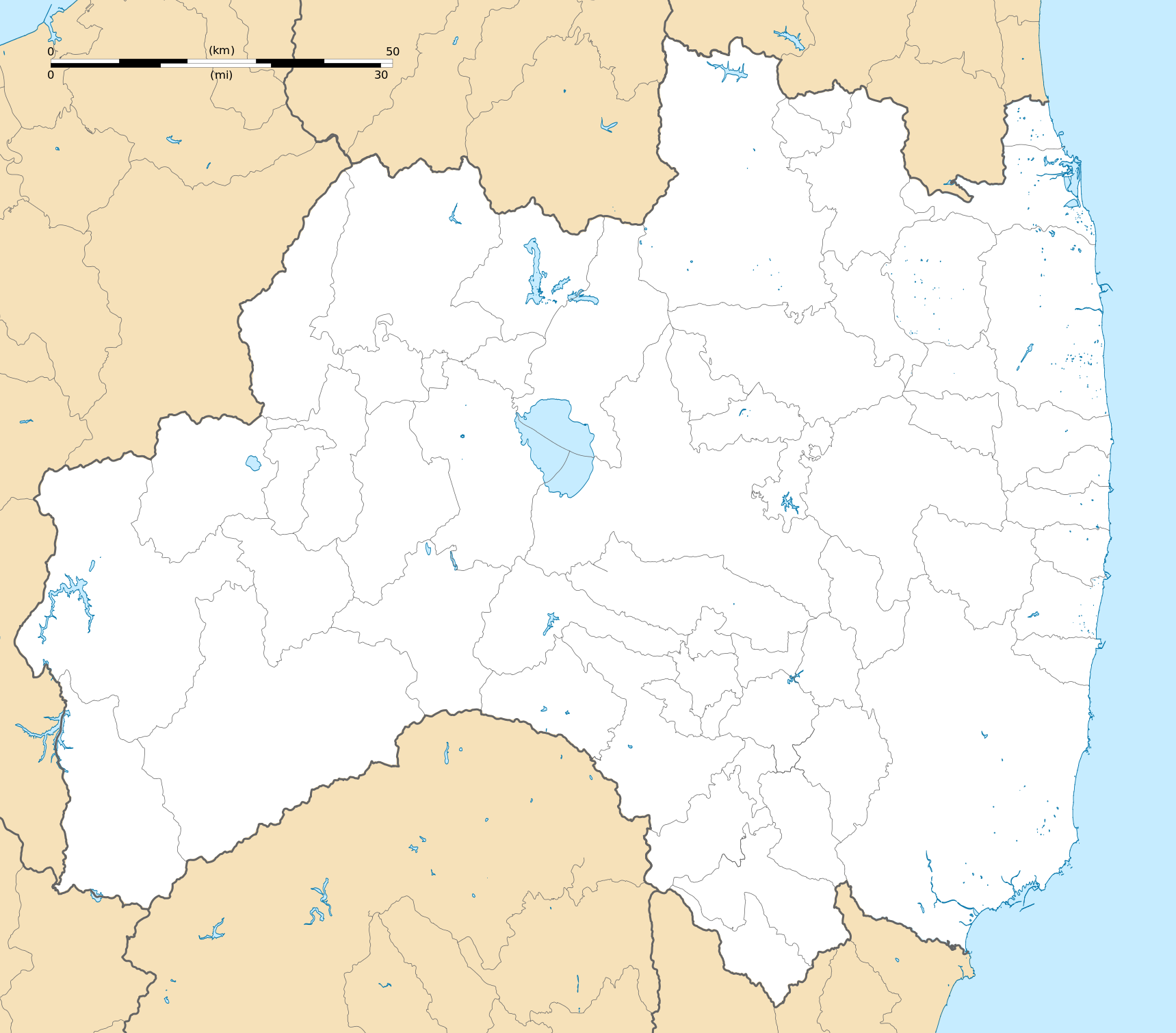
311: : équirectangulaire + vertical stretching +40% ; système géodésique WGS84
105:
537:
I, the copyright holder of this work, hereby publish it under the following license:
1383:
1218:
1008:
978:
408:
346:
1588:
1688:
1633:
389:
1518:
1503:
1668:
1578:
522:
282:
1678:
1508:
341: : données de la carte © les contributeurs d'OpenStreetMap, CC-BY-SA
1593:
945:, destinée à la géolocalisation.}} {{de|Karte der [[:de:Präfektur F...
1728:
1723:
1638:
339:
Coast, lakes, river, boundaries / Côtes, lacs, cours d'eau, frontières
1753:
1623:
1523:
151:
1763:
1603:
1583:
942:
887:
Click on a date/time to view the file as it appeared at that time.
200:
1608:
1718:
448:
1768:
1748:
1738:
1683:
844:
508:
153:
1733:
342:
1708:
652:
136:
93:
87:(SVG file, nominally 1,719 × 1,509 pixels, file size: 2.99 MB)
1703:
1698:
1598:
1713:
642:
447:
Any use of this image can be made as long as you credit me (
1743:
1693:
146:
37° 00′ 00″ N, 140° 00′ 00″ E
1758:
1534:
Plantilla:Mapa de localización de
Prefectura de Fukushima
626:
https://creativecommons.org/licenses/by-sa/2.0/fr/deed.en
455:
with a reply address would also be greatly appreciated.
712:
Add a one-line explanation of what this file represents
382:
376:
1628:
179:
117:
Commons is a freely licensed media file repository.
499:to clean up, improve, create or translate as well.
798:Creative Commons Attribution-ShareAlike 2.0 France
1494:Plantilya:Location map Japan Fukushima Prefecture
1569:Vorlage:Positionskarte Japan Präfektur Fukushima
1514:Vorlage:Positionskarte Japan Präfektur Fukushima
632:Creative Commons Attribution-Share Alike 2.0 fr
1614:Modèle:Géolocalisation/Préfecture de Fukushima
1544:پودمان:Location map Japan Fukushima Prefecture
98:
543:
468:File:Fukushima-ken géolocalisation relief.svg
8:
1619:Module:Carte/données/préfecture de fukushima
1549:الگو:Location map Japan Fukushima Prefecture
1484:قالب:Location map Japan Fukushima Prefecture
592:– to copy, distribute and transmit the work
46:Size of this PNG preview of this SVG file:
1793:
889:
708:
475:
436:
1476:The following other wikis use this file:
487:This map was improved or created by the
1811:
1803:
1795:
961:
865:
849:
831:
815:
795:
779:
759:
743:
726:
723:
704:
697:
445:
139:
160:View this and other nearby images on:
7:
441:Attribution and Share-Alike required
878:
554:
549:
1786:
717:
711:
566:Attribution-Share Alike 2.0 France
540:
536:
513:
486:
449:Wikimedia Commons user: Bourrichon
276:
275:
264:
253:
241:
229:
217:
205:
189:
130:
80:
1634:Stade de baseball Fukushima Azuma
716:
185:Fukushima-ken géolocalisation.svg
1519:Fukushima Azuma Baseball Stadium
852:coordinates of the point of view
702:
603:Under the following conditions:
561:This file is licensed under the
553:
548:
542:
507:
479:
254:
203:, destinée à la géolocalisation.
166:
152:
97:
31:
21:
1589:Accident nucléaire de Fukushima
1504:Kernkraftwerk Fukushima Daiichi
1209:Kawahigashi Station (Fukushima)
699:
665:View the annotations at Commons
355:Other symbols / autres symboles
242:
230:
218:
14:
698:
265:
227:, for geolocalisation purpose.
206:
190:
26:
1:
1679:Templat:Peta lokasi Fukushima
1664:תבנית:מפת מיקום/מחוז פוקושימה
1659:תחנת הכוח הגרעינית פוקושימה 1
1509:Kernkraftwerk Fukushima Daini
1034:Fukushima Station (Fukushima)
367:Software / logiciels utilisés
291:Approximate geographic limits
36:
1689:Stasiun Kōriyama (Fukushima)
1579:Château d'Aizuwakamatsu
1244:Kōriyama Station (Fukushima)
724:Items portrayed in this file
438:
334:Création personnelle ;
1565:Usage on frr.wikipedia.org
1490:Usage on ceb.wikipedia.org
1199:Kashima Station (Fukushima)
867:37°0'0.000"N, 140°0'0.000"E
1833:
1675:Usage on id.wikipedia.org
1645:Usage on he.wikipedia.org
1624:Gare d'Aizu-Wakamatsu
1575:Usage on fr.wikipedia.org
1540:Usage on fa.wikipedia.org
1530:Usage on es.wikipedia.org
1500:Usage on de.wikipedia.org
1480:Usage on ar.wikipedia.org
1399:Sugita Station (Fukushima)
1234:Kusano Station (Fukushima)
1079:Hirono Station (Fukushima)
939:fr:Préfecture de Fukushima
617:same or compatible license
392:pour le relief de la NASA.
1729:Stasiun Higashi-Fukushima
1724:Stasiun Iwaki (Fukushima)
1149:Iwaki Station (Fukushima)
1064:Higashi-Fukushima Station
879:
662:This image is annotated:
359:File:Maps template-fr.svg
281:Carta de la província de
16:
1609:Barrage d'Okutadami
1429:Ueda Station (Fukushima)
1259:Minami-Fukushima Station
1069:Higashi-Nagahara Station
701:
583:
104:This is a file from the
1524:Hawaiians Stadium Iwaki
1104:Inawashirokohan Station
1019:Eda Station (Fukushima)
936:
478:
463:
424:
403:
329:
321:
318:
249:Prefettura di Fukushima
237:Prefectura de Fukushima
197:Préfecture de Fukushima
182:
108:. Information from its
1604:Gare de Shin-Shirakawa
1554:ورزشگاه فوکوشیما آزوما
1364:Shin-Shirakawa Station
1134:Iwaki-Tanakura Station
1129:Iwaki-Moriyama Station
1124:Iwaki-Ishikawa Station
989:Asaka-Nagamori Station
974:Aizu-Wakamatsu Station
647:
172:37.000000; 140.000000
111:description page there
1594:Château de Nihonmatsu
1439:Yamatsuriyama Station
1359:Satoshiraishi Station
1154:Izumi Station (Iwaki)
1109:Iwaki-Asakawa Station
969:Aizu-Toyokawa Station
646:
1719:Stasiun Iwaki-Tokiwa
1639:Château de Shigiyama
1264:Minami-Ishii Station
1139:Iwaki-Tokiwa Station
1114:Iwaki-Hanawa Station
1039:Fukushima University
994:Bandai-Atami Station
225:Fukushima Prefecture
74:1,719 × 1,509 pixels
70:2,333 × 2,048 pixels
66:1,167 × 1,024 pixels
1769:Stasiun Haranomachi
1749:Stasiun Aizu-Yokota
1344:Ononiimachi Station
1119:Iwaki-Ishii Station
1074:Higashidate Station
1059:Haranomachi Station
1054:Gohyakugawa Station
999:Bandaimachi Station
915:15:19, 10 July 2013
598:– to adapt the work
495:(fr). You can
371:dans ce didacticiel
213:Präfektur Fukushima
195:Carte vierge de la
52:Other resolutions:
1754:Stasiun Aizu-Ōshio
1734:Stasiun Aizu-Bange
1339:Okinashima Station
1304:Nihonmatsu Station
1224:Komagamine Station
1189:Kanayagawa Station
1174:Kagamiishi Station
1099:Inawashiro Station
1089:Hisanohama Station
648:
528:
323:3 July 2013, 18:49
301:* O : 139.14
299:* E : 141.15
1820:
1819:
1800:Generated with Qt
1778:more global usage
1764:Stasiun Iwaki-Ōta
1584:Château de Komine
1472:Global file usage
1454:Yotsukura Station
1379:Shirasaka Station
1374:Shirakawa Station
1249:Matsukawa Station
1204:Kawabeoki Station
1164:Izumizaki Station
1144:Iwaki-Ōta Station
1029:Fukushima Airport
948:
782:copyright license
710:
671:
670:
578:atelier graphique
521:was created with
505:
504:
503:
473:
472:
459:
458:
433:
430:Reusing this file
399:
395:
369:(méthode décrite
312:
302:
295:* N : 38.02
293:of the map :
223:Blank map of the
177:
176:
126:
125:
106:Wikimedia Commons
32:Global file usage
1824:
1794:
1704:Stasiun Kanameta
1699:Stasiun Funehiki
1599:Barrage Fujinuma
1559:ایستگاه فوکوشیما
1449:Yonomori Station
1444:Yatagawa Station
1404:Sukagawa Station
1389:Suetsugi Station
1354:Sasakino Station
1319:Nogisawa Station
1314:Niwasaka Station
1284:Nakatoyo Station
1274:Motomiya Station
1269:Momouchi Station
1184:Kanameta Station
1044:Funehiki Station
1004:Chikatsu Station
927:
746:copyright status
693:Knyamokatekachi
653:
645:
639:
636:
633:
630:
627:
619:as the original.
581:
563:Creative Commons
557:
556:
552:
551:
546:
545:
511:
483:
476:
437:
427:
415:
398:
365:
324:
307:
297:* S : 36.76
289:
280:
269:
258:
246:
234:
222:
210:
194:
192:Français :
186:
180:
173:
170:
156:
155:
149:
148:
137:
122:
101:
100:
94:
88:
77:
62:875 × 768 pixels
58:547 × 480 pixels
54:273 × 240 pixels
48:683 × 600 pixels
1832:
1831:
1827:
1826:
1825:
1823:
1822:
1821:
1782:
1714:Stasiun Kanmata
1654:פוקושימה (מחוז)
1470:
1414:Tomioka Station
1409:Tatsuta Station
1369:Shinchi Station
1329:Ogawagō Station
1309:Nittaki Station
1214:Kawamae Station
1194:Kanmata Station
1159:Izumigō Station
949:
933:
925:
881:
880:
877:
876:
875:
874:
873:
872:
871:
870:
868:
858:
857:
856:
854:
843:
842:
841:
840:
839:
838:
837:
836:
834:
824:
823:
822:
820:
809:
808:
807:
806:
805:
804:
803:
802:
800:
788:
787:
786:
784:
773:
772:
771:
770:
769:
768:
767:
766:
764:
752:
751:
750:
748:
737:
736:
735:
734:
733:
731:
715:
714:
713:
696:
695:
690:
687:
684:
681:
678:
675:
659:
651:
650:
649:
643:
640:
637:
634:
631:
629:CC BY-SA 2.0 fr
628:
625:
624:
582:
572:
569:
558:
539:
538:
533:
527:
526:
516:W3C-unspecified
500:
474:
413:
286:
274:
263:
252:
240:
228:
216:
204:
184:
171:
144:
143:
140:Camera location
135:
128:
127:
116:
115:
114:is shown below.
90:
86:
79:
78:
51:
12:
11:
5:
1830:
1828:
1818:
1817:
1814:
1810:
1809:
1806:
1802:
1801:
1798:
1785:
1780:of this file.
1774:
1773:
1772:
1771:
1766:
1761:
1756:
1751:
1746:
1744:Stasiun Natsui
1741:
1739:Stasiun Tōdera
1736:
1731:
1726:
1721:
1716:
1711:
1706:
1701:
1696:
1694:Stasiun Miharu
1691:
1686:
1684:Stasiun Uchigō
1681:
1673:
1672:
1671:
1666:
1661:
1656:
1651:
1643:
1642:
1641:
1636:
1631:
1626:
1621:
1616:
1611:
1606:
1601:
1596:
1591:
1586:
1581:
1573:
1572:
1571:
1563:
1562:
1561:
1556:
1551:
1546:
1538:
1537:
1536:
1528:
1527:
1526:
1521:
1516:
1511:
1506:
1498:
1497:
1496:
1488:
1487:
1486:
1474:
1473:
1468:to this file.
1462:
1461:
1459:Yumoto Station
1456:
1451:
1446:
1441:
1436:
1434:Yabuki Station
1431:
1426:
1424:Uchigō Station
1421:
1416:
1411:
1406:
1401:
1396:
1394:Sugaya Station
1391:
1386:
1381:
1376:
1371:
1366:
1361:
1356:
1351:
1349:Oshioe Station
1346:
1341:
1336:
1334:Oikawa Station
1331:
1326:
1321:
1316:
1311:
1306:
1301:
1299:Natsui Station
1296:
1291:
1289:Nakoso Station
1286:
1281:
1276:
1271:
1266:
1261:
1256:
1254:Miharu Station
1251:
1246:
1241:
1239:Kutano Station
1236:
1231:
1226:
1221:
1216:
1211:
1206:
1201:
1196:
1191:
1186:
1181:
1176:
1171:
1166:
1161:
1156:
1151:
1146:
1141:
1136:
1131:
1126:
1121:
1116:
1111:
1106:
1101:
1096:
1094:Hiwada Station
1091:
1086:
1084:Hirota Station
1081:
1076:
1071:
1066:
1061:
1056:
1051:
1049:Futaba Station
1046:
1041:
1036:
1031:
1026:
1024:Fujita Station
1021:
1016:
1014:Dōjima Station
1011:
1006:
1001:
996:
991:
986:
984:Akaiwa Station
981:
976:
971:
966:
964:Adachi Station
959:is available.
953:
952:
947:
946:
935:
931:
928:
924:1,719 × 1,509
922:
917:
912:
908:
907:
904:
901:
898:
895:
892:
885:
884:
869:
866:
864:
863:
862:
861:
860:
859:
855:
850:
848:
847:
846:
845:
835:
832:
830:
829:
828:
827:
826:
825:
821:
816:
814:
813:
812:
811:
810:
801:
796:
794:
793:
792:
791:
790:
789:
785:
780:
778:
777:
776:
775:
774:
765:
760:
758:
757:
756:
755:
754:
753:
749:
744:
742:
741:
740:
739:
738:
732:
727:
725:
722:
721:
720:
719:
718:
707:
706:
703:
700:
691:
688:
685:
682:
679:
676:
673:
672:
669:
668:
660:
657:
641:
623:
622:
621:
620:
610:
601:
600:
599:
593:
586:You are free:
570:
560:
559:
541:
535:
534:
532:
529:
506:
502:
501:
497:propose images
484:
471:
470:
465:
464:Other versions
461:
460:
457:
456:
444:
443:
434:
422:
421:
405:
401:
400:
397:
396:
394:
393:
386:
380:
362:
361:
351:
350:
331:
327:
326:
320:
316:
315:
314:
313:
304:
303:
187:
178:
175:
174:
164:
158:
141:
134:
131:
129:
124:
123:
102:
92:
91:
45:
41:
40:
39:
34:
29:
24:
19:
13:
10:
9:
6:
4:
3:
2:
1829:
1815:
1812:
1807:
1804:
1799:
1796:
1792:
1789:
1783:
1781:
1779:
1770:
1767:
1765:
1762:
1760:
1759:Stasiun Odaka
1757:
1755:
1752:
1750:
1747:
1745:
1742:
1740:
1737:
1735:
1732:
1730:
1727:
1725:
1722:
1720:
1717:
1715:
1712:
1710:
1707:
1705:
1702:
1700:
1697:
1695:
1692:
1690:
1687:
1685:
1682:
1680:
1677:
1676:
1674:
1670:
1667:
1665:
1662:
1660:
1657:
1655:
1652:
1650:
1647:
1646:
1644:
1640:
1637:
1635:
1632:
1630:
1627:
1625:
1622:
1620:
1617:
1615:
1612:
1610:
1607:
1605:
1602:
1600:
1597:
1595:
1592:
1590:
1587:
1585:
1582:
1580:
1577:
1576:
1574:
1570:
1567:
1566:
1564:
1560:
1557:
1555:
1552:
1550:
1547:
1545:
1542:
1541:
1539:
1535:
1532:
1531:
1529:
1525:
1522:
1520:
1517:
1515:
1512:
1510:
1507:
1505:
1502:
1501:
1499:
1495:
1492:
1491:
1489:
1485:
1482:
1481:
1479:
1478:
1477:
1471:
1469:
1467:
1460:
1457:
1455:
1452:
1450:
1447:
1445:
1442:
1440:
1437:
1435:
1432:
1430:
1427:
1425:
1422:
1420:
1419:Ubadō Station
1417:
1415:
1412:
1410:
1407:
1405:
1402:
1400:
1397:
1395:
1392:
1390:
1387:
1385:
1382:
1380:
1377:
1375:
1372:
1370:
1367:
1365:
1362:
1360:
1357:
1355:
1352:
1350:
1347:
1345:
1342:
1340:
1337:
1335:
1332:
1330:
1327:
1325:
1324:Odaka Station
1322:
1320:
1317:
1315:
1312:
1310:
1307:
1305:
1302:
1300:
1297:
1295:
1294:Namie Station
1292:
1290:
1287:
1285:
1282:
1280:
1277:
1275:
1272:
1270:
1267:
1265:
1262:
1260:
1257:
1255:
1252:
1250:
1247:
1245:
1242:
1240:
1237:
1235:
1232:
1230:
1229:Koori Station
1227:
1225:
1222:
1220:
1217:
1215:
1212:
1210:
1207:
1205:
1202:
1200:
1197:
1195:
1192:
1190:
1187:
1185:
1182:
1180:
1179:Kaida Station
1177:
1175:
1172:
1170:
1167:
1165:
1162:
1160:
1157:
1155:
1152:
1150:
1147:
1145:
1142:
1140:
1137:
1135:
1132:
1130:
1127:
1125:
1122:
1120:
1117:
1115:
1112:
1110:
1107:
1105:
1102:
1100:
1097:
1095:
1092:
1090:
1087:
1085:
1082:
1080:
1077:
1075:
1072:
1070:
1067:
1065:
1062:
1060:
1057:
1055:
1052:
1050:
1047:
1045:
1042:
1040:
1037:
1035:
1032:
1030:
1027:
1025:
1022:
1020:
1017:
1015:
1012:
1010:
1007:
1005:
1002:
1000:
997:
995:
992:
990:
987:
985:
982:
980:
977:
975:
972:
970:
967:
965:
962:
960:
958:
950:
944:
940:
934:
929:
923:
921:
918:
916:
913:
910:
909:
905:
902:
899:
896:
893:
891:
890:
888:
882:
853:
819:
799:
783:
763:
747:
730:
694:
667:
666:
661:
655:
654:
618:
614:
611:
608:
605:
604:
602:
597:
594:
591:
588:
587:
585:
584:
579:
575:
571:Attribution:
567:
564:
547:
530:
524:
520:
517:
510:
498:
494:
490:
489:Wikigraphists
485:
482:
477:
469:
466:
462:
454:
450:
446:
442:
439:
435:
431:
426:
423:
420:
419:fr:Bourrichon
416:
410:
406:
402:
391:
390:Global Mapper
387:
384:
381:
378:
375:
374:
372:
368:
364:
363:
360:
357:provenant de
356:
353:
352:
348:
344:
343:Openstreetmap
340:
337:
336:
335:
332:
328:
317:
310:
306:
305:
300:
298:
296:
294:
292:
288:
287:
284:
279:
272:
268:
261:
257:
250:
245:
238:
233:
226:
221:
214:
209:
202:
198:
193:
188:
181:
169:
165:
163:
162:OpenStreetMap
159:
157:
147:
142:
138:
132:
120:
113:
112:
107:
103:
96:
95:
89:
84:
83:Original file
75:
71:
67:
63:
59:
55:
49:
44:
38:
35:
33:
30:
28:
25:
23:
20:
18:
15:
1790:
1787:
1775:
1709:Stasiun Ōgoe
1475:
1463:
1384:Soma Station
1279:Mōgi Station
1219:Kido Station
1169:Jōko Station
1009:Date Station
979:Akai Station
954:
886:
883:File history
692:
663:
612:
606:
595:
589:
519:vector image
515:
440:
366:
354:
347:thinkgeo.com
338:
333:
308:
290:
277:
266:
255:
247:Mappa della
243:
231:
219:
207:
191:
119:You can help
109:
81:
22:File history
1797:Image title
833:3 July 2013
762:copyrighted
656:Annotations
613:share alike
607:attribution
493:Graphic Lab
377:Quantum GIS
278:Português:
235:Mapa de la
183:Description
1466:more links
951:File usage
932:Bourrichon
900:Dimensions
574:Bourrichon
425:Permission
409:Bourrichon
309:Projection
244:Italiano:
211:Karte der
27:File usage
1808:1719.0001
1629:J-Village
957:full list
926:(2.99 MB)
897:Thumbnail
894:Date/Time
818:inception
658:InfoField
531:Licensing
373:) :
283:Fukushima
232:Español:
220:English:
208:Deutsch:
1784:Metadata
1649:פוקושימה
705:Captions
596:to remix
590:to share
568:license.
523:Inkscape
383:Inkscape
37:Metadata
911:current
906:Comment
729:depicts
709:English
491:of the
453:message
385: ;
379: ;
349: ;
273:의 지도이다.
133:Summary
85:
1813:Height
512:
404:Author
330:Source
150:
1805:Width
1776:View
1669:נארהה
1464:View
943:Japon
941:, au
514:This
325:(UTC)
271:후쿠시마현
267:한국어:
201:Japon
199:, au
1816:1509
903:User
689:1509
686:1719
638:true
635:true
417:) -
414:talk
345:via
319:Date
262:の地図.
256:日本語:
17:File
677:724
674:106
260:福島県
683:35
680:28
407:©
72:|
68:|
64:|
60:|
56:|
50:.
580:)
576:(
525:.
432:)
428:(
411:(
388:+
285:.
251:.
239:.
215:.
121:.
76:.
Text is available under the Creative Commons Attribution-ShareAlike License. Additional terms may apply.
