33:
386:
319:
269:
311:
261:
333:
283:
354:
392:
397:
89:
881:"}},"text\/plain":{"en":{"":"heading"}}},"{\"value\":{\"amount\":\"+315\",\"unit\":\"http:\\\/\\\/www.wikidata.org\\\/entity\\\/Q28390\"},\"type\":\"quantity\"}":{"text\/html":{"en":{"P7787":"315
817:"}},"text\/plain":{"en":{"":"heading"}}},"{\"value\":{\"amount\":\"+315\",\"unit\":\"http:\\\/\\\/www.wikidata.org\\\/entity\\\/Q28390\"},\"type\":\"quantity\"}":{"text\/html":{"en":{"P7787":"315
983:
813:
147:
Opened in 1838 as "Stoneclough" by the
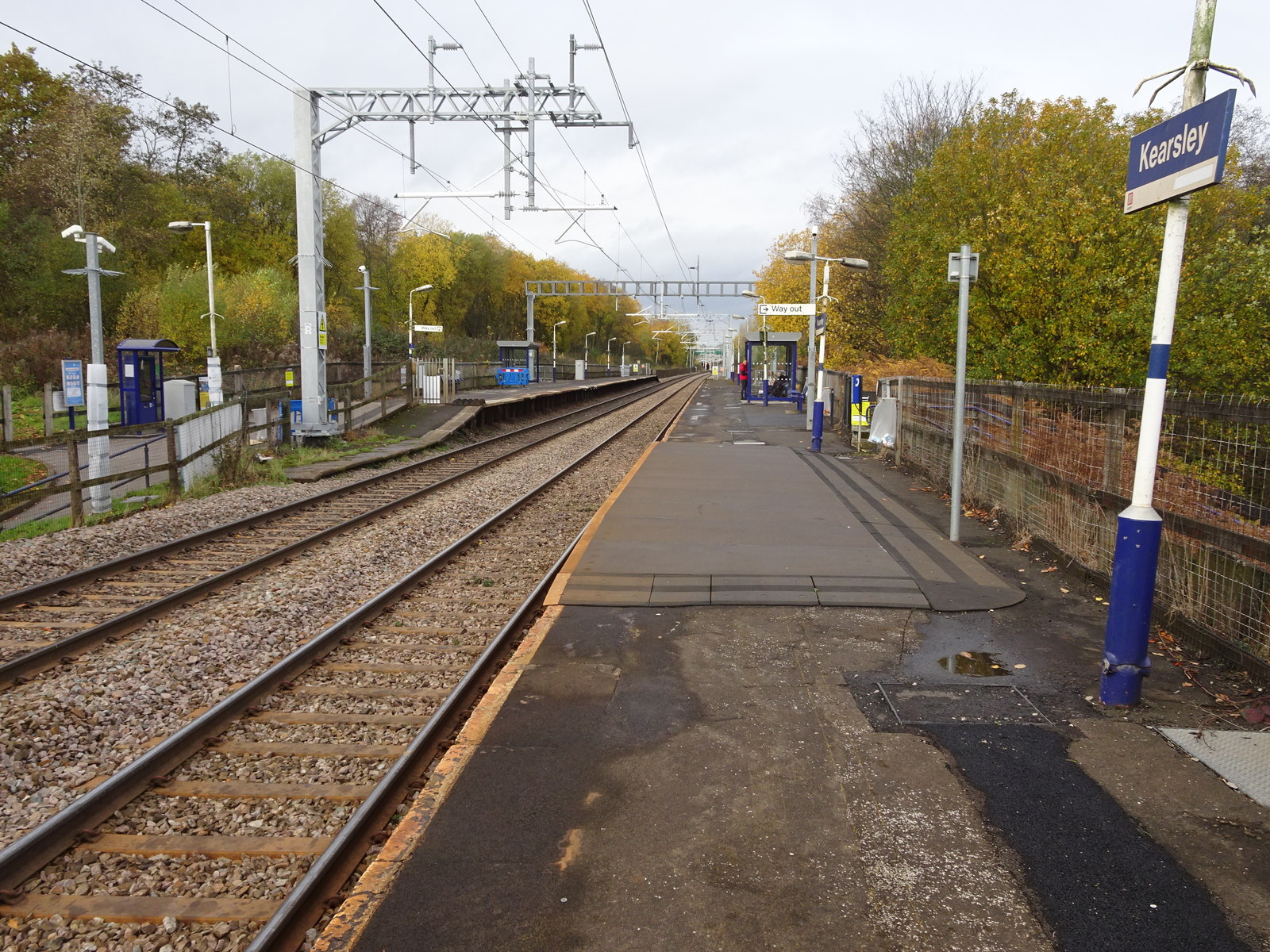
Manchester and Bolton Railway, later part of the Lancashire & Yorkshire Railway, this station's name was changed around 1900 (needs confirmation) to "Kearsley". View north west towards Farnworth and Bolton, shortly after the line was
252:
55:
51:
47:
43:
37:
68:
444:– You must give appropriate credit, provide a link to the license, and indicate if changes were made. You may do so in any reasonable manner, but not in any way that suggests the licensor endorses you or your use.
100:
878:
814:
982:
977:
59:
32:
189:
715:
679:
643:
326:
276:
765:
524:
361:
451:
606:
919:
892:
855:
828:
728:
699:
627:
599:
584:
571:
786:
758:
743:
663:
544:
508:
348:
1014:
407:
1010:
The following pages on the
English Knowledge (XXG) use this file (pages on other projects are not listed):
450:– If you remix, transform, or build upon the material, you must distribute your contributions under the
368:
on the
Geograph website for the photographer's contact details. The copyright on this image is owned by
404:
885:"}},"text\/plain":{"en":{"P7787":"315 degree"}}}}": -->
821:"}},"text\/plain":{"en":{"P7787":"315 degree"}}}}": -->
108:
993:
750:
735:
591:
205:
332:
282:
373:
95:
221:
266:
316:
157:
178:
168:
353:
365:
950:
Click on a date/time to view the file as it appeared at that time.
133:
Kearsley railway station, Greater
Manchester (geograph 5975429).jpg
318:
268:
293:
243:
83:
303:
53° 32′ 39.8″ N, 2° 22′ 32″ W
253:
53° 32′ 39.1″ N, 2° 22′ 30″ W
492:
Add a one-line explanation of what this file represents
73:(1,600 × 1,200 pixels, file size: 617 KB, MIME type:
196:
Creative
Commons Attribution Share-alike license 2.0
127:
107:
Commons is a freely licensed media file repository.
680:
Creative
Commons Attribution-ShareAlike 2.0 Generic
461:https://creativecommons.org/licenses/by-sa/2.0
88:
467:Creative Commons Attribution-Share Alike 2.0
385:
8:
236:Kearsley railway station, Greater Manchester
217:Kearsley railway station, Greater Manchester
144:Kearsley railway station, Greater Manchester
882:
818:
427:– to copy, distribute and transmit the work
952:
488:
751:https://www.geograph.org.uk/photo/5975429
592:https://www.geograph.org.uk/profile/84225
1012:
906:
890:
842:
826:
800:
784:
713:
697:
677:
661:
641:
625:
558:
542:
522:
506:
503:
484:
477:
296:
246:
1000:Transferred from geograph.co.uk using
325:View this and other nearby images on:
275:View this and other nearby images on:
7:
372:and is licensed for reuse under the
941:
408:Attribution-Share Alike 2.0 Generic
396:
391:
376:Attribution-ShareAlike 2.0 license.
497:
491:
382:
359:
137:
120:
66:
496:
829:coordinates of the point of view
482:
438:Under the following conditions:
403:This file is licensed under the
395:
390:
384:
352:
331:
317:
309:
281:
267:
259:
87:
21:
479:
138:
14:
716:file available on the internet
478:
360:This image was taken from the
26:
1:
893:coordinates of depicted place
844:53°32'39.124"N, 2°22'29.888"W
766:Geograph Britain and Ireland
600:object of statement has role
504:Items portrayed in this file
308:
258:
908:53°32'39.77"N, 2°22'31.51"W
234:Nigel Thompson /
215:Nigel Thompson /
1031:
452:same or compatible license
942:
16:
1015:Kearsley railway station
729:geograph.org.uk image ID
525:Kearsley railway station
481:
418:
94:This is a file from the
999:
206:required by the license
184:
174:
163:
156:
153:
130:
98:. Information from its
366:this photograph's page
337:53.544380; -2.375420
287:53.544201; -2.374969
101:description page there
36:Size of this preview:
978:18:01, 14 August 2019
60:1,600 × 1,200 pixels
433:– to adapt the work
42:Other resolutions:
572:author name string
56:1,280 × 960 pixels
52:1,024 × 768 pixels
1003:
884:
820:
664:copyright license
490:
381:
380:
364:collection. See
342:
341:
292:
291:
241:
240:
209:
193:
190:Reusing this file
116:
115:
96:Wikimedia Commons
1022:
990:
930:
929:
924:
866:
865:
860:
802:14 November 2018
768:
763:
753:
748:
744:described at URL
738:
733:
628:copyright status
609:
604:
594:
589:
579:
576:
474:
471:
468:
465:
462:
454:as the original.
416:
405:Creative Commons
399:
398:
394:
393:
388:
387:
374:Creative Commons
362:Geograph project
356:
349:
338:
335:
321:
320:
314:
313:
312:
306:
305:
294:
288:
285:
271:
270:
264:
263:
262:
256:
255:
244:
203:
187:
159:
158:14 November 2018
142:
134:
128:
112:
91:
90:
84:
78:
76:
63:
48:640 × 480 pixels
44:320 × 240 pixels
38:800 × 600 pixels
1030:
1029:
1025:
1024:
1023:
1021:
1020:
1019:
1011:
1004:
996:
988:
944:
943:
940:
939:
938:
937:
936:
935:
934:
933:
932:
931:
927:
925:
922:
913:
912:
911:
909:
899:
898:
897:
895:
876:
875:
874:
873:
872:
871:
870:
869:
868:
867:
863:
861:
858:
849:
848:
847:
845:
835:
834:
833:
831:
812:
811:
810:
809:
808:
807:
806:
805:
803:
793:
792:
791:
789:
778:
777:
776:
775:
774:
773:
772:
771:
770:
769:
764:
761:
755:
754:
749:
746:
740:
739:
734:
731:
722:
721:
720:
718:
706:
705:
704:
702:
691:
690:
689:
688:
687:
686:
685:
684:
682:
670:
669:
668:
666:
655:
654:
653:
652:
651:
650:
649:
648:
646:
634:
633:
632:
630:
619:
618:
617:
616:
615:
614:
613:
612:
611:
610:
605:
602:
596:
595:
590:
587:
581:
580:
577:
574:
565:
564:
563:
561:
551:
550:
549:
547:
536:
535:
534:
533:
532:
531:
530:
529:
527:
515:
514:
513:
511:
495:
494:
493:
476:
475:
472:
469:
466:
463:
460:
459:
417:
414:
411:
400:
377:
347:
336:
310:
301:
300:
297:Object location
286:
260:
251:
250:
247:Camera location
242:
231:
224:
212:
169:geograph.org.uk
149:
132:
125:
118:
117:
106:
105:
104:is shown below.
80:
74:
72:
65:
64:
41:
12:
11:
5:
1028:
1026:
1018:
1017:
1009:
1008:
1007:
1002:
1001:
998:
994:
991:
987:1,600 × 1,200
985:
980:
975:
971:
970:
967:
964:
961:
958:
955:
948:
947:
918:
917:
916:
915:
914:
910:
907:
905:
904:
903:
902:
901:
900:
896:
891:
889:
888:
887:
886:
880:
854:
853:
852:
851:
850:
846:
843:
841:
840:
839:
838:
837:
836:
832:
827:
825:
824:
823:
822:
816:
804:
801:
799:
798:
797:
796:
795:
794:
790:
785:
783:
782:
781:
780:
779:
757:
756:
742:
741:
727:
726:
725:
724:
723:
719:
714:
712:
711:
710:
709:
708:
707:
703:
700:source of file
698:
696:
695:
694:
693:
692:
683:
678:
676:
675:
674:
673:
672:
671:
667:
662:
660:
659:
658:
657:
656:
647:
642:
640:
639:
638:
637:
636:
635:
631:
626:
624:
623:
622:
621:
620:
598:
597:
583:
582:
578:Nigel Thompson
570:
569:
568:
567:
566:
562:
559:
557:
556:
555:
554:
553:
552:
548:
543:
541:
540:
539:
538:
537:
528:
523:
521:
520:
519:
518:
517:
516:
512:
507:
505:
502:
501:
500:
499:
498:
487:
486:
483:
480:
458:
457:
456:
455:
445:
436:
435:
434:
428:
421:You are free:
415:Nigel Thompson
412:
402:
401:
383:
379:
378:
370:Nigel Thompson
357:
346:
343:
340:
339:
329:
323:
298:
290:
289:
279:
273:
248:
239:
238:
232:
229:
226:
225:
220:
213:
210:
198:
197:
194:
182:
181:
179:Nigel Thompson
176:
172:
171:
165:
161:
160:
155:
151:
150:
135:
126:
124:
121:
119:
114:
113:
92:
82:
81:
35:
31:
30:
29:
24:
19:
13:
10:
9:
6:
4:
3:
2:
1027:
1016:
1013:
1005:
997:
992:
986:
984:
981:
979:
976:
973:
972:
968:
965:
962:
959:
956:
954:
953:
951:
945:
921:
894:
857:
830:
788:
767:
760:
752:
745:
737:
730:
717:
701:
681:
665:
645:
629:
608:
601:
593:
586:
573:
546:
526:
510:
464:CC BY-SA 2.0
453:
449:
446:
443:
440:
439:
437:
432:
429:
426:
423:
422:
420:
419:
413:Attribution:
409:
406:
389:
375:
371:
367:
363:
358:
355:
351:
350:
344:
334:
330:
328:
327:OpenStreetMap
324:
322:
304:
299:
295:
284:
280:
278:
277:OpenStreetMap
274:
272:
254:
249:
245:
237:
233:
228:
227:
223:
219: /
218:
214:
207:
202:
200:
199:
195:
191:
186:
183:
180:
177:
173:
170:
166:
162:
152:
146:
145:
141:
136:
129:
122:
110:
103:
102:
97:
93:
86:
85:
79:
70:
69:Original file
61:
57:
53:
49:
45:
39:
34:
28:
25:
23:
20:
18:
15:
949:
946:File history
607:photographer
447:
441:
430:
424:
369:
307:
257:
235:
222:CC BY-SA 2.0
216:
148:electrified.
143:
139:
109:You can help
99:
67:
22:File history
995:Lamberhurst
644:copyrighted
448:share alike
442:attribution
201:Attribution
131:Description
1006:File usage
963:Dimensions
560:some value
185:Permission
75:image/jpeg
27:File usage
960:Thumbnail
957:Date/Time
787:inception
345:Licensing
230:InfoField
211:InfoField
140:English:
989:(617 KB)
759:operator
485:Captions
431:to remix
425:to share
410:license.
974:current
969:Comment
920:heading
879:heading
856:heading
815:heading
736:5975429
545:creator
509:depicts
489:English
123:Summary
71:
928:degree
883:degree
864:degree
819:degree
315:
265:
175:Author
164:Source
167:From
966:User
926:315
862:315
473:true
470:true
154:Date
17:File
585:URL
923::
859::
762::
747::
732::
603::
588::
575::
58:|
54:|
50:|
46:|
40:.
208:)
204:(
192:)
188:(
111:.
77:)
62:.
Text is available under the Creative Commons Attribution-ShareAlike License. Additional terms may apply.
.jpg)
.jpg¶ms=053.544201_N_-002.374969_E_globe:Earth_type:camera_source:geograph-osgb36(SD75250535)_heading:315.00&language=en)
.jpg¶ms=053.544380_N_-002.375420_E_globe:Earth_class:object_type:object_source:geograph-osgb36(SD75220537)_heading:315.00&language=en)
