351:
281:
231:
273:
223:
295:
245:
319:
357:
362:
72:
846:"}},"text\/plain":{"en":{"":"heading"}}},"{\"value\":{\"amount\":\"+315\",\"unit\":\"http:\\\/\\\/www.wikidata.org\\\/entity\\\/Q28390\"},\"type\":\"quantity\"}":{"text\/html":{"en":{"P7787":"315
782:"}},"text\/plain":{"en":{"":"heading"}}},"{\"value\":{\"amount\":\"+315\",\"unit\":\"http:\\\/\\\/www.wikidata.org\\\/entity\\\/Q28390\"},\"type\":\"quantity\"}":{"text\/html":{"en":{"P7787":"315
842:
264:
214:
965:== {{int:filedesc}} == {{Information |description={{en|1=Kilmogue Portal Dolmen. This portal dolmen was built by our neolithic forefathers about 6000 years ago. I grew up close to this place and loved to climb over it and into it as a kid. }} |date=2004-0
43:
409:– You must give appropriate credit, provide a link to the license, and indicate if changes were made. You may do so in any reasonable manner, but not in any way that suggests the licensor endorses you or your use.
83:
126:
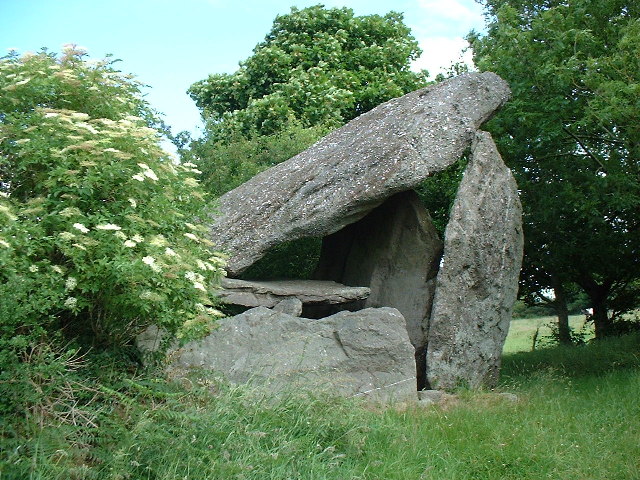
Kilmogue Portal Dolmen. This portal dolmen was built by our neolithic forefathers about 6000 years ago. I grew up close to this place and loved to climb over it and into it as a kid.
51:
843:
779:
984:
680:
644:
608:
288:
238:
715:
489:
1147:
326:
1116:
1020:
This file contains additional information, probably added from the digital camera or scanner used to create or digitize it.
416:
558:
884:
857:
820:
793:
723:
664:
592:
566:
551:
536:
947:
942:
42:
751:
708:
693:
628:
509:
473:
313:
372:
1023:
If the file has been modified from its original state, some details may not fully reflect the modified file.
989:
975:
The following pages on the
English Knowledge (XXG) use this file (pages on other projects are not listed):
1200:
415:– If you remix, transform, or build upon the material, you must distribute your contributions under the
333:
on the
Geograph website for the photographer's contact details. The copyright on this image is owned by
958:
1042:
369:
850:"}},"text\/plain":{"en":{"P7787":"315 degree"}}}}": -->
786:"}},"text\/plain":{"en":{"P7787":"315 degree"}}}}": -->
1228:
91:
183:
730:
700:
543:
167:
979:
294:
244:
1290:
1218:
1174:
338:
78:
1079:
1238:
1059:
278:
228:
135:
156:
146:
1280:
1049:
1032:
318:
330:
915:
Click on a date/time to view the file as it appeared at that time.
280:
230:
255:
205:
66:
265:
52° 24′ 11″ N, 7° 15′ 44″ W
215:
52° 24′ 11″ N, 7° 15′ 44″ W
457:
Add a one-line explanation of what this file represents
1007:
116:
Kilmogue Portal Dolmen - geograph.org.uk - 103548.jpg
52:
Kilmogue_Portal_Dolmen_-_geograph.org.uk_-_103548.jpg
110:
90:
Commons is a freely licensed media file repository.
645:
Creative
Commons Attribution-ShareAlike 2.0 Generic
56:(640 × 480 pixels, file size: 145 KB, MIME type:
426:https://creativecommons.org/licenses/by-sa/2.0
71:
432:Creative Commons Attribution-Share Alike 2.0
350:
8:
847:
783:
392:– to copy, distribute and transmit the work
1025:
917:
453:
1000:The following other wikis use this file:
985:User:Mrchris/Timeline of County Kilkenny
701:https://www.geograph.org.uk/photo/103548
544:https://www.geograph.org.uk/profile/1861
1288:
1278:
1270:
1262:
1254:
1246:
1236:
1226:
1216:
1208:
1198:
1190:
1182:
1172:
1164:
1156:
1145:
1137:
1129:
1121:
1111:
1103:
1095:
1087:
1076:
1068:
1057:
1047:
1037:
977:
871:
855:
807:
791:
765:
749:
678:
662:
642:
626:
606:
590:
523:
507:
487:
471:
468:
449:
442:
258:
208:
1117:Digital Camera FinePix1400Zoom Ver1.00
287:View this and other nearby images on:
237:View this and other nearby images on:
1027:
7:
337:and is licensed for reuse under the
906:
373:Attribution-Share Alike 2.0 Generic
361:
356:
341:Attribution-ShareAlike 2.0 license.
1018:
462:
456:
347:
324:
120:
103:
49:
461:
1070:Date and time of data generation
794:coordinates of the point of view
447:
403:Under the following conditions:
368:This file is licensed under the
360:
355:
349:
317:
293:
279:
271:
243:
229:
221:
70:
31:
21:
444:
121:
46:No higher resolution available.
14:
681:file available on the internet
443:
325:This image was taken from the
26:
1:
858:coordinates of depicted place
36:
716:Geograph Britain and Ireland
552:object of statement has role
469:Items portrayed in this file
270:
220:
1264:Focal plane resolution unit
1158:Date and time of digitizing
873:52°24'11.02"N, 7°15'43.92"W
809:52°24'11.02"N, 7°15'43.92"W
1312:
1275:One-chip color area sensor
1004:Usage on www.wikidata.org
417:same or compatible license
1123:File change date and time
907:
16:
1256:Focal plane Y resolution
1248:Focal plane X resolution
724:geograph.org.uk image ID
446:
383:
77:This is a file from the
964:
168:required by the license
152:
141:
134:
131:
113:
81:. Information from its
1166:Image compression mode
990:Portal:County Kilkenny
943:23:49, 30 January 2010
331:this photograph's page
299:52.403060; -7.262200
249:52.403060; -7.262200
198:Kilmogue Portal Dolmen
196:Ned Dwyer /
179:Kilmogue Portal Dolmen
177:Ned Dwyer /
84:description page there
1210:Maximum land aperture
1097:Horizontal resolution
490:Kilmogue Portal Tomb
1161:10:53, 27 June 2004
1131:Y and C positioning
1126:10:53, 27 June 2004
1105:Vertical resolution
1073:10:53, 27 June 2004
1029:Camera manufacturer
398:– to adapt the work
1295:Auto white balance
1233:Flash did not fire
567:author name string
1299:
1298:
1213:3.7 APEX (f/3.61)
996:Global file usage
968:
849:
785:
629:copyright license
455:
346:
345:
329:collection. See
304:
303:
254:
253:
203:
202:
171:
99:
98:
79:Wikimedia Commons
32:Global file usage
1303:
1139:Exposure Program
1026:
955:
895:
894:
889:
831:
830:
825:
733:
728:
718:
713:
703:
698:
694:described at URL
593:copyright status
574:
571:
561:
556:
546:
541:
439:
436:
433:
430:
427:
419:as the original.
381:
370:Creative Commons
364:
363:
359:
358:
353:
352:
339:Creative Commons
327:Geograph project
321:
314:
300:
297:
283:
282:
276:
275:
274:
268:
267:
256:
250:
247:
233:
232:
226:
225:
224:
218:
217:
206:
165:
137:
125:
117:
111:
95:
74:
73:
67:
61:
59:
1311:
1310:
1306:
1305:
1304:
1302:
1301:
1300:
1192:APEX brightness
1043:FinePix1400Zoom
1014:
994:
980:County Kilkenny
976:
969:
961:
953:
909:
908:
905:
904:
903:
902:
901:
900:
899:
898:
897:
896:
892:
890:
887:
878:
877:
876:
874:
864:
863:
862:
860:
841:
840:
839:
838:
837:
836:
835:
834:
833:
832:
828:
826:
823:
814:
813:
812:
810:
800:
799:
798:
796:
777:
776:
775:
774:
773:
772:
771:
770:
768:
758:
757:
756:
754:
743:
742:
741:
740:
739:
738:
737:
736:
735:
734:
729:
726:
720:
719:
714:
711:
705:
704:
699:
696:
687:
686:
685:
683:
671:
670:
669:
667:
656:
655:
654:
653:
652:
651:
650:
649:
647:
635:
634:
633:
631:
620:
619:
618:
617:
616:
615:
614:
613:
611:
599:
598:
597:
595:
584:
583:
582:
581:
580:
579:
578:
577:
576:
575:
572:
569:
563:
562:
557:
554:
548:
547:
542:
539:
530:
529:
528:
526:
516:
515:
514:
512:
501:
500:
499:
498:
497:
496:
495:
494:
492:
480:
479:
478:
476:
460:
459:
458:
441:
440:
437:
434:
431:
428:
425:
424:
382:
379:
376:
365:
342:
312:
298:
272:
263:
262:
259:Object location
248:
222:
213:
212:
209:Camera location
204:
193:
186:
174:
147:geograph.org.uk
127:
115:
108:
101:
100:
89:
88:
87:is shown below.
63:
57:
55:
48:
47:
12:
11:
5:
1309:
1307:
1297:
1296:
1293:
1287:
1286:
1283:
1277:
1276:
1273:
1272:Sensing method
1269:
1268:
1265:
1261:
1260:
1257:
1253:
1252:
1249:
1245:
1244:
1241:
1235:
1234:
1231:
1225:
1224:
1221:
1215:
1214:
1211:
1207:
1206:
1203:
1197:
1196:
1193:
1189:
1188:
1185:
1181:
1180:
1177:
1171:
1170:
1167:
1163:
1162:
1159:
1155:
1154:
1151:
1144:
1143:
1142:Normal program
1140:
1136:
1135:
1132:
1128:
1127:
1124:
1120:
1119:
1114:
1110:
1109:
1106:
1102:
1101:
1098:
1094:
1093:
1090:
1086:
1085:
1082:
1075:
1074:
1071:
1067:
1066:
1063:
1056:
1055:
1052:
1046:
1045:
1040:
1036:
1035:
1030:
1017:
1013:
1012:
1011:
1010:
998:
997:
993:
992:
987:
982:
974:
973:
972:
967:
966:
963:
959:
956:
950:
945:
940:
936:
935:
932:
929:
926:
923:
920:
913:
912:
883:
882:
881:
880:
879:
875:
872:
870:
869:
868:
867:
866:
865:
861:
856:
854:
853:
852:
851:
845:
819:
818:
817:
816:
815:
811:
808:
806:
805:
804:
803:
802:
801:
797:
792:
790:
789:
788:
787:
781:
769:
766:
764:
763:
762:
761:
760:
759:
755:
750:
748:
747:
746:
745:
744:
722:
721:
707:
706:
692:
691:
690:
689:
688:
684:
679:
677:
676:
675:
674:
673:
672:
668:
665:source of file
663:
661:
660:
659:
658:
657:
648:
643:
641:
640:
639:
638:
637:
636:
632:
627:
625:
624:
623:
622:
621:
612:
607:
605:
604:
603:
602:
601:
600:
596:
591:
589:
588:
587:
586:
585:
565:
564:
550:
549:
535:
534:
533:
532:
531:
527:
524:
522:
521:
520:
519:
518:
517:
513:
508:
506:
505:
504:
503:
502:
493:
488:
486:
485:
484:
483:
482:
481:
477:
472:
470:
467:
466:
465:
464:
463:
452:
451:
448:
445:
423:
422:
421:
420:
410:
401:
400:
399:
393:
386:You are free:
377:
367:
366:
348:
344:
343:
322:
311:
308:
302:
301:
291:
285:
260:
252:
251:
241:
235:
210:
201:
200:
194:
191:
188:
187:
182:
175:
172:
160:
159:
154:
150:
149:
143:
139:
138:
133:
129:
128:
118:
109:
107:
104:
102:
97:
96:
75:
65:
64:
45:
41:
40:
39:
34:
29:
24:
19:
13:
10:
9:
6:
4:
3:
2:
1308:
1294:
1292:
1291:White balance
1289:
1284:
1282:
1279:
1274:
1271:
1266:
1263:
1258:
1255:
1250:
1247:
1242:
1240:
1237:
1232:
1230:
1227:
1222:
1220:
1219:Metering mode
1217:
1212:
1209:
1204:
1202:
1201:Exposure bias
1199:
1194:
1191:
1186:
1184:APEX aperture
1183:
1178:
1176:
1175:Shutter speed
1173:
1168:
1165:
1160:
1157:
1152:
1149:
1146:
1141:
1138:
1133:
1130:
1125:
1122:
1118:
1115:
1113:Software used
1112:
1107:
1104:
1099:
1096:
1091:
1088:
1083:
1081:
1077:
1072:
1069:
1064:
1061:
1058:
1053:
1051:
1048:
1044:
1041:
1038:
1034:
1031:
1028:
1024:
1021:
1015:
1009:
1006:
1005:
1003:
1002:
1001:
995:
991:
988:
986:
983:
981:
978:
970:
962:
957:
951:
949:
946:
944:
941:
938:
937:
933:
930:
927:
924:
921:
919:
918:
916:
910:
886:
859:
822:
795:
753:
732:
725:
717:
710:
702:
695:
682:
666:
646:
630:
610:
594:
568:
560:
553:
545:
538:
511:
491:
475:
429:CC BY-SA 2.0
418:
414:
411:
408:
405:
404:
402:
397:
394:
391:
388:
387:
385:
384:
378:Attribution:
374:
371:
354:
340:
336:
332:
328:
323:
320:
316:
315:
309:
307:
306:
296:
292:
290:
289:OpenStreetMap
286:
284:
266:
261:
257:
246:
242:
240:
239:OpenStreetMap
236:
234:
216:
211:
207:
199:
195:
190:
189:
185:
181: /
180:
176:
169:
164:
162:
161:
158:
155:
151:
148:
144:
140:
130:
124:
119:
112:
105:
93:
86:
85:
80:
76:
69:
68:
62:
53:
44:
38:
35:
33:
30:
28:
25:
23:
20:
18:
15:
1080:focal length
1039:Camera model
1022:
1019:
999:
914:
911:File history
559:photographer
412:
406:
395:
389:
334:
305:
269:
219:
197:
184:CC BY-SA 2.0
178:
122:
92:You can help
82:
50:
22:File history
1239:Color space
1089:Orientation
960:GeographBot
609:copyrighted
413:share alike
407:attribution
163:Attribution
114:Description
971:File usage
952:640 × 480
928:Dimensions
525:some value
58:image/jpeg
27:File usage
1281:Sharpness
1060:ISO speed
925:Thumbnail
922:Date/Time
767:June 2004
752:inception
573:Ned Dwyer
380:Ned Dwyer
335:Ned Dwyer
310:Licensing
192:InfoField
173:InfoField
157:Ned Dwyer
136:June 2004
123:English:
1134:Co-sited
1050:F-number
1033:FUJIFILM
1016:Metadata
1008:Q1235940
954:(145 KB)
709:operator
450:Captions
396:to remix
390:to share
375:license.
37:Metadata
1223:Pattern
1150:version
939:current
934:Comment
885:heading
844:heading
821:heading
780:heading
510:creator
474:depicts
454:English
106:Summary
54:
1108:72 dpi
1100:72 dpi
1092:Normal
1062:rating
893:degree
848:degree
829:degree
784:degree
731:103548
277:
227:
153:Author
142:Source
1259:2,453
1251:2,453
1229:Flash
1078:Lens
1054:f/3.6
145:From
1243:sRGB
1148:Exif
1084:6 mm
931:User
891:315
827:315
438:true
435:true
132:Date
17:File
1195:6.7
1187:3.7
1179:8.4
1153:2.1
1065:125
537:URL
888::
824::
727::
712::
697::
570::
555::
540::
1285:3
1267:3
1205:0
1169:2
170:)
166:(
94:.
60:)
Text is available under the Creative Commons Attribution-ShareAlike License. Additional terms may apply.
_region:IE_heading:315.00&language=en)
_region:IE_heading:315.00&language=en)
