321:
256:
270:
289:
327:
332:
72:
924:
435:
The
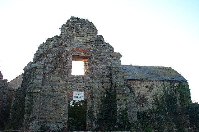
Chantry at Kilve The chantry was founded in 1329 by five monks but fell into disrepair before the dissolution of the monasteries. Creative Commons Licence © Copyright Barbara Cook and licensed for reuse under this Creative
941:{{Information |Description={{en|The Chantry at Kilve.The chantry was founded in 1329 by five monks but fell into disrepair before the dissolution of the monasteries.}} |Source=Transferred from |Date=2007-12-31 (origi
379:– You must give appropriate credit, provide a link to the license, and indicate if changes were made. You may do so in any reasonable manner, but not in any way that suggests the licensor endorses you or your use.
980:
247:
43:
955:
975:
184:
970:
965:
143:
The
Chantry at Kilve.The chantry was founded in 1329 by five monks but fell into disrepair before the dissolution of the monasteries.
869:
712:
642:
606:
263:
1058:
833:
732:
487:
1144:
296:
1036:
This file contains additional information, probably added from the digital camera or scanner used to create or digitize it.
386:
569:
853:
817:
783:
740:
696:
590:
562:
549:
534:
755:
725:
662:
626:
507:
471:
283:
342:
83:
1039:
If the file has been modified from its original state, some details may not fully reflect the modified file.
51:
951:
The following pages on the
English Knowledge (XXG) use this file (pages on other projects are not listed):
1202:
1048:
385:– If you remix, transform, or build upon the material, you must distribute your contributions under the
303:
on the
Geograph website for the photographer's contact details. The copyright on this image is owned by
339:
115:
1238:
91:
216:
110:
541:
200:
762:
747:
269:
1013:
1220:
1184:
1073:
985:
960:
308:
78:
1102:
923:
918:
42:
1256:
934:
430:
253:
152:
173:
163:
1083:
288:
300:
891:
Click on a date/time to view the file as it appeared at that time.
255:
776:
248:
51° 11′ 19.75″ N, 3° 13′ 24.17″ W
238:
66:
1003:
455:
Add a one-line explanation of what this file represents
422:
1023:
191:
Creative
Commons Attribution Share-alike license 2.0
127:
104:
90:
Commons is a freely licensed media file repository.
643:
Creative
Commons Attribution-ShareAlike 2.0 Generic
981:List of scheduled monuments in West Somerset (H–Z)
425:. All following user names refer to en.wikipedia.
56:(640 × 425 pixels, file size: 71 KB, MIME type:
396:https://creativecommons.org/licenses/by-sa/2.0
71:
402:Creative Commons Attribution-Share Alike 2.0
320:
8:
1014:Somerset'teki civil parishlerin listesi
956:Grade II* listed buildings in West Somerset
362:– to copy, distribute and transmit the work
1041:
893:
451:
996:The following other wikis use this file:
542:https://www.geograph.org.uk/profile/2948
1288:
1280:
1272:
1264:
1254:
1246:
1236:
1228:
1218:
1210:
1200:
1192:
1182:
1161:
1153:
1142:
1134:
1126:
1118:
1110:
1099:
1091:
1081:
1071:
1063:
1053:
953:
867:
851:
831:
815:
797:
781:
763:https://www.geograph.org.uk/photo/80361
710:
694:
676:
660:
640:
624:
604:
588:
521:
505:
485:
469:
466:
447:
440:
241:
262:View this and other nearby images on:
1043:
7:
307:and is licensed for reuse under the
976:List of monastic houses in Somerset
882:
343:Attribution-Share Alike 2.0 Generic
331:
326:
311:Attribution-ShareAlike 2.0 license.
1034:
971:List of monastic houses in England
966:List of civil parishes in Somerset
460:
454:
421:The original description page was
420:
317:
294:
137:
108:
103:
49:
459:
1093:Date and time of data generation
1068:KODAK DC280 ZOOM DIGITAL CAMERA
784:coordinates of the point of view
445:
373:Under the following conditions:
338:This file is licensed under the
330:
325:
319:
287:
268:
254:
70:
31:
21:
1059:KODAK DC280 ZOOM DIGITAL CAMERA
442:
138:
46:No higher resolution available.
14:
713:file available on the internet
441:
295:This image was taken from the
26:
1:
1293:A directly photographed image
36:
1078:1/90 sec (0.011111111111111)
733:Geograph Britain and Ireland
563:object of statement has role
467:Items portrayed in this file
1155:Date and time of digitizing
799:51°11'19.75"N, 3°13'24.17"W
1310:
1277:One-chip color area sensor
1248:Supported Flashpix version
1020:Usage on www.wikidata.org
1010:Usage on tr.wikipedia.org
1000:Usage on nl.wikipedia.org
433:640×425×??? (72622 bytes)
387:same or compatible license
1163:Meaning of each component
883:
870:Somerset West and Taunton
229:Barbara Cook /
210:Barbara Cook /
16:
919:10:14, 15 September 2008
741:geograph.org.uk image ID
444:
353:
77:This is a file from the
940:
201:required by the license
179:
169:
158:
151:
148:
130:
81:. Information from its
301:this photograph's page
274:51.188820; -3.223380
84:description page there
1212:Maximum land aperture
1120:Horizontal resolution
1049:EASTMAN KODAK COMPANY
1285:Digital still camera
854:location of creation
231:The Chantry at Kilve
212:The Chantry at Kilve
1136:Y and C positioning
1128:Vertical resolution
1045:Camera manufacturer
417:Original upload log
368:– to adapt the work
109:This is a photo of
1243:Flash did not fire
1158:15:38, 5 July 1999
1096:15:38, 5 July 1999
550:author name string
1297:
1296:
1215:3.1 APEX (f/2.93)
992:Global file usage
944:
627:copyright license
453:
429:2007-12-31 22:01
316:
315:
299:collection. See
279:
278:
236:
235:
204:
188:
185:Reusing this file
125:
124:
99:
98:
79:Wikimedia Commons
32:Global file usage
1301:
1065:Copyright holder
1042:
931:
834:Kodak DC280 Zoom
765:
760:
756:described at URL
750:
745:
735:
730:
678:18 November 2005
591:copyright status
572:
567:
557:
554:
544:
539:
409:
406:
403:
400:
397:
389:as the original.
351:
340:Creative Commons
334:
333:
329:
328:
323:
322:
309:Creative Commons
297:Geograph project
291:
284:
275:
272:
258:
257:
251:
250:
239:
198:
182:
154:
153:18 November 2005
142:
134:
133:Kilvechantry.jpg
128:
118:
105:
95:
74:
73:
67:
61:
59:
52:Kilvechantry.jpg
1309:
1308:
1304:
1303:
1302:
1300:
1299:
1298:
1030:
990:
952:
945:
937:
929:
885:
884:
881:
880:
879:
878:
877:
876:
875:
874:
872:
860:
859:
858:
856:
845:
844:
843:
842:
841:
840:
839:
838:
836:
824:
823:
822:
820:
809:
808:
807:
806:
805:
804:
803:
802:
800:
790:
789:
788:
786:
775:
774:
773:
772:
771:
770:
769:
768:
767:
766:
761:
758:
752:
751:
746:
743:
737:
736:
731:
728:
719:
718:
717:
715:
703:
702:
701:
699:
688:
687:
686:
685:
684:
683:
682:
681:
679:
669:
668:
667:
665:
654:
653:
652:
651:
650:
649:
648:
647:
645:
633:
632:
631:
629:
618:
617:
616:
615:
614:
613:
612:
611:
609:
597:
596:
595:
593:
582:
581:
580:
579:
578:
577:
576:
575:
574:
573:
568:
565:
559:
558:
555:
552:
546:
545:
540:
537:
528:
527:
526:
524:
514:
513:
512:
510:
499:
498:
497:
496:
495:
494:
493:
492:
490:
478:
477:
476:
474:
458:
457:
456:
426:
419:
411:
410:
407:
404:
401:
398:
395:
394:
352:
349:
346:
335:
312:
273:
246:
245:
242:Camera location
237:
226:
219:
207:
164:geograph.org.uk
144:
132:
120:
114:
111:listed building
101:
100:
89:
88:
87:is shown below.
63:
57:
55:
48:
47:
12:
11:
5:
1307:
1305:
1295:
1294:
1291:
1287:
1286:
1283:
1279:
1278:
1275:
1274:Sensing method
1271:
1270:
1267:
1266:Exposure index
1263:
1262:
1259:
1253:
1252:
1249:
1245:
1244:
1241:
1235:
1234:
1231:
1227:
1226:
1223:
1217:
1216:
1213:
1209:
1208:
1205:
1199:
1198:
1195:
1191:
1190:
1187:
1181:
1180:
1179:
1178:
1177:does not exist
1175:
1172:
1169:
1164:
1160:
1159:
1156:
1152:
1151:
1148:
1141:
1140:
1137:
1133:
1132:
1129:
1125:
1124:
1121:
1117:
1116:
1113:
1109:
1108:
1105:
1098:
1097:
1094:
1090:
1089:
1086:
1080:
1079:
1076:
1070:
1069:
1066:
1062:
1061:
1056:
1052:
1051:
1046:
1033:
1029:
1028:
1027:
1026:
1018:
1017:
1016:
1008:
1007:
1006:
994:
993:
989:
988:
983:
978:
973:
968:
963:
958:
950:
949:
948:
943:
942:
939:
935:
932:
926:
921:
916:
912:
911:
908:
905:
902:
899:
896:
889:
888:
873:
868:
866:
865:
864:
863:
862:
861:
857:
852:
850:
849:
848:
847:
846:
837:
832:
830:
829:
828:
827:
826:
825:
821:
816:
814:
813:
812:
811:
810:
801:
798:
796:
795:
794:
793:
792:
791:
787:
782:
780:
779:
778:
777:
754:
753:
739:
738:
724:
723:
722:
721:
720:
716:
711:
709:
708:
707:
706:
705:
704:
700:
697:source of file
695:
693:
692:
691:
690:
689:
680:
677:
675:
674:
673:
672:
671:
670:
666:
661:
659:
658:
657:
656:
655:
646:
641:
639:
638:
637:
636:
635:
634:
630:
625:
623:
622:
621:
620:
619:
610:
605:
603:
602:
601:
600:
599:
598:
594:
589:
587:
586:
585:
584:
583:
561:
560:
548:
547:
533:
532:
531:
530:
529:
525:
522:
520:
519:
518:
517:
516:
515:
511:
506:
504:
503:
502:
501:
500:
491:
486:
484:
483:
482:
481:
480:
479:
475:
470:
468:
465:
464:
463:
462:
461:
450:
449:
446:
443:
439:
438:
418:
415:
393:
392:
391:
390:
380:
371:
370:
369:
363:
356:You are free:
347:
337:
336:
318:
314:
313:
292:
277:
276:
266:
260:
243:
234:
233:
227:
224:
221:
220:
215:
208:
205:
193:
192:
189:
177:
176:
171:
167:
166:
160:
156:
155:
150:
146:
145:
135:
126:
123:
122:
102:
97:
96:
75:
65:
64:
45:
41:
40:
39:
34:
29:
24:
19:
13:
10:
9:
6:
4:
3:
2:
1306:
1292:
1289:
1284:
1281:
1276:
1273:
1268:
1265:
1260:
1258:
1255:
1250:
1247:
1242:
1240:
1237:
1232:
1229:
1224:
1222:
1221:Metering mode
1219:
1214:
1211:
1206:
1204:
1203:Exposure bias
1201:
1196:
1194:APEX aperture
1193:
1188:
1186:
1185:Shutter speed
1183:
1176:
1173:
1170:
1167:
1166:
1165:
1162:
1157:
1154:
1149:
1146:
1143:
1138:
1135:
1130:
1127:
1122:
1119:
1114:
1111:
1106:
1104:
1100:
1095:
1092:
1087:
1085:
1082:
1077:
1075:
1074:Exposure time
1072:
1067:
1064:
1060:
1057:
1054:
1050:
1047:
1044:
1040:
1037:
1031:
1025:
1022:
1021:
1019:
1015:
1012:
1011:
1009:
1005:
1004:West Somerset
1002:
1001:
999:
998:
997:
991:
987:
986:West Somerset
984:
982:
979:
977:
974:
972:
969:
967:
964:
962:
961:Kilve Chantry
959:
957:
954:
946:
938:
933:
927:
925:
922:
920:
917:
914:
913:
909:
906:
903:
900:
897:
895:
894:
892:
886:
871:
855:
835:
819:
818:captured with
785:
764:
757:
749:
742:
734:
727:
714:
698:
664:
644:
628:
608:
592:
571:
564:
551:
543:
536:
509:
489:
488:Kilve Chantry
473:
437:
432:
428:
427:
424:
416:
414:
413:
399:CC BY-SA 2.0
388:
384:
381:
378:
375:
374:
372:
367:
364:
361:
358:
357:
355:
354:
348:Attribution:
344:
341:
324:
310:
306:
302:
298:
293:
290:
286:
285:
282:
281:
271:
267:
265:
264:OpenStreetMap
261:
259:
249:
244:
240:
232:
228:
223:
222:
218:
214: /
213:
209:
202:
197:
195:
194:
190:
186:
181:
178:
175:
172:
168:
165:
161:
157:
147:
141:
136:
129:
121:
117:
112:
107:
106:
93:
86:
85:
80:
76:
69:
68:
62:
53:
44:
38:
35:
33:
30:
28:
25:
23:
20:
18:
15:
1230:Light source
1103:focal length
1055:Camera model
1038:
1035:
995:
890:
887:File history
570:photographer
556:Barbara Cook
434:
412:
382:
376:
365:
359:
350:Barbara Cook
305:Barbara Cook
304:
280:
230:
217:CC BY-SA 2.0
211:
174:Barbara Cook
139:
92:You can help
82:
50:
22:File history
1282:File source
1257:Color space
1112:Orientation
607:copyrighted
383:share alike
377:attribution
196:Attribution
131:Description
1290:Scene type
947:File usage
928:640 × 425
904:Dimensions
523:some value
180:Permission
58:image/jpeg
27:File usage
901:Thumbnail
898:Date/Time
663:inception
225:InfoField
206:InfoField
140:English:
1139:Centered
1084:F-number
1032:Metadata
1024:Q6408268
726:operator
448:Captions
366:to remix
360:to share
345:license.
37:Metadata
1233:Unknown
1225:Average
1147:version
1131:192 dpi
1123:192 dpi
930:(71 KB)
915:current
910:Comment
508:creator
472:depicts
452:English
116:1345688
113:number
54:
1115:Normal
1107:6.3 mm
936:TimTay
252:
170:Author
159:Source
1239:Flash
1101:Lens
1088:f/5.6
748:80361
162:From
1261:sRGB
1145:Exif
907:User
431:Rodw
423:here
408:true
405:true
149:Date
17:File
1269:100
1189:6.5
1150:2.1
535:URL
1174:Cr
1171:Cb
759::
744::
729::
566::
553::
538::
436:Co
1251:1
1207:0
1197:5
1168:Y
203:)
199:(
187:)
183:(
119:.
94:.
60:)
Text is available under the Creative Commons Attribution-ShareAlike License. Additional terms may apply.
