349:
282:
232:
274:
224:
296:
246:
317:
355:
360:
72:
825:"}},"text\/plain":{"en":{"":"heading"}}},"{\"value\":{\"amount\":\"+22\",\"unit\":\"http:\\\/\\\/www.wikidata.org\\\/entity\\\/Q28390\"},\"type\":\"quantity\"}":{"text\/html":{"en":{"P7787":"22
761:"}},"text\/plain":{"en":{"":"heading"}}},"{\"value\":{\"amount\":\"+22\",\"unit\":\"http:\\\/\\\/www.wikidata.org\\\/entity\\\/Q28390\"},\"type\":\"quantity\"}":{"text\/html":{"en":{"P7787":"22
821:
126:
Kirkpatrick
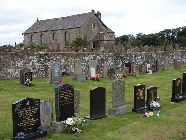
Fleming Church Kirkpatrick Fleming Parish Church has been substantially rebuilt since 1726 but retains earlier masonry including a bellcote of 1733. Image of the church taken from the cemetery (S section) and over the old graveyard. The cemetery (E and S sections) contain seven war graves
265:
215:
978:== {{int:filedesc}} == {{Information |description={{en|1=Kirkpatrick Fleming Church Kirkpatrick Fleming Parish Church has been substantially rebuilt since 1726 but retains earlier masonry including a bellcote of 1733. Image of the church taken from the ce
43:
407:– You must give appropriate credit, provide a link to the license, and indicate if changes were made. You may do so in any reasonable manner, but not in any way that suggests the licensor endorses you or your use.
83:
51:
822:
758:
659:
623:
587:
289:
239:
694:
324:
1033:
This file contains additional information, probably added from the digital camera or scanner used to create or digitize it.
960:
955:
414:
42:
550:
892:
863:
836:
799:
772:
672:
643:
571:
543:
528:
515:
730:
702:
687:
607:
488:
471:
311:
370:
1036:
If the file has been modified from its original state, some details may not fully reflect the modified file.
988:
The following pages on the
English Knowledge (XXG) use this file (pages on other projects are not listed):
413:– If you remix, transform, or build upon the material, you must distribute your contributions under the
331:
on the
Geograph website for the photographer's contact details. The copyright on this image is owned by
971:
367:
992:
829:"}},"text\/plain":{"en":{"P7787":"22 degree"}}}}": -->
765:"}},"text\/plain":{"en":{"P7787":"22 degree"}}}}": -->
91:
184:
535:
709:
679:
168:
295:
245:
336:
78:
136:
279:
229:
157:
147:
316:
328:
928:
Click on a date/time to view the file as it appeared at that time.
1010:
281:
231:
256:
206:
66:
266:
55° 01′ 12.8″ N, 3° 07′ 58″ W
216:
55° 01′ 11.1″ N, 3° 07′ 59″ W
127:
including 4 members of the
British Honduras Forestry Unit.
116:
Kirkpatrick
Fleming Church - geograph.org.uk - 698604.jpg
52:
Kirkpatrick_Fleming_Church_-_geograph.org.uk_-_698604.jpg
455:
Add a one-line explanation of what this file represents
1020:
110:
90:
Commons is a freely licensed media file repository.
624:
Creative
Commons Attribution-ShareAlike 2.0 Generic
56:(640 × 480 pixels, file size: 90 KB, MIME type:
424:https://creativecommons.org/licenses/by-sa/2.0
71:
430:Creative Commons Attribution-Share Alike 2.0
348:
8:
826:
762:
390:– to copy, distribute and transmit the work
1038:
930:
451:
1003:The following other wikis use this file:
536:https://www.geograph.org.uk/profile/21838
710:https://www.geograph.org.uk/photo/698604
1040:
990:
906:
890:
850:
834:
786:
770:
744:
728:
657:
641:
621:
605:
585:
569:
502:
486:
469:
466:
447:
440:
259:
209:
288:View this and other nearby images on:
238:View this and other nearby images on:
7:
335:and is licensed for reuse under the
919:
371:Attribution-Share Alike 2.0 Generic
359:
354:
339:Attribution-ShareAlike 2.0 license.
1031:
460:
454:
345:
322:
120:
103:
49:
459:
773:coordinates of the point of view
445:
401:Under the following conditions:
366:This file is licensed under the
358:
353:
347:
315:
294:
280:
272:
244:
230:
222:
70:
31:
21:
442:
121:
46:No higher resolution available.
14:
660:file available on the internet
441:
323:This image was taken from the
26:
1:
837:coordinates of depicted place
36:
695:Geograph Britain and Ireland
544:object of statement has role
467:Items portrayed in this file
1007:Usage on sco.wikipedia.org
271:
221:
1062:
1017:Usage on www.wikidata.org
415:same or compatible license
199:Kirkpatrick Fleming Church
180:Kirkpatrick Fleming Church
920:
852:55°1'12.76"N, 3°7'57.72"W
788:55°1'11.10"N, 3°7'58.80"W
197:Chris Newman /
178:Chris Newman /
16:
673:geograph.org.uk image ID
444:
381:
77:This is a file from the
977:
169:required by the license
153:
142:
135:
132:
113:
81:. Information from its
956:05:17, 8 February 2011
329:this photograph's page
300:55.020210; -3.132700
250:55.019750; -3.133000
84:description page there
1011:Kirkpaitrick Fleemin
993:Kirkpatrick-Fleming
396:– to adapt the work
516:author name string
1049:
1048:
999:Global file usage
981:
828:
764:
746:10 September 2005
608:copyright license
453:
344:
343:
327:collection. See
305:
304:
255:
254:
204:
203:
172:
137:10 September 2005
99:
98:
79:Wikimedia Commons
32:Global file usage
1053:
1039:
968:
874:
873:
868:
810:
809:
804:
712:
707:
703:described at URL
697:
692:
682:
677:
572:copyright status
553:
548:
538:
533:
523:
520:
437:
434:
431:
428:
425:
417:as the original.
379:
368:Creative Commons
362:
361:
357:
356:
351:
350:
337:Creative Commons
325:Geograph project
319:
312:
301:
298:
284:
283:
277:
276:
275:
269:
268:
257:
251:
248:
234:
233:
227:
226:
225:
219:
218:
207:
166:
138:
125:
117:
111:
95:
74:
73:
67:
61:
59:
1061:
1060:
1056:
1055:
1054:
1052:
1051:
1050:
1027:
997:
989:
982:
974:
966:
922:
921:
918:
917:
916:
915:
914:
913:
912:
911:
909:
899:
898:
897:
895:
884:
883:
882:
881:
880:
879:
878:
877:
876:
875:
871:
869:
866:
857:
856:
855:
853:
843:
842:
841:
839:
820:
819:
818:
817:
816:
815:
814:
813:
812:
811:
807:
805:
802:
793:
792:
791:
789:
779:
778:
777:
775:
756:
755:
754:
753:
752:
751:
750:
749:
747:
737:
736:
735:
733:
722:
721:
720:
719:
718:
717:
716:
715:
714:
713:
708:
705:
699:
698:
693:
690:
684:
683:
678:
675:
666:
665:
664:
662:
650:
649:
648:
646:
635:
634:
633:
632:
631:
630:
629:
628:
626:
614:
613:
612:
610:
599:
598:
597:
596:
595:
594:
593:
592:
590:
578:
577:
576:
574:
563:
562:
561:
560:
559:
558:
557:
556:
555:
554:
549:
546:
540:
539:
534:
531:
525:
524:
521:
518:
509:
508:
507:
505:
495:
494:
493:
491:
480:
479:
478:
477:
476:
474:
458:
457:
456:
439:
438:
435:
432:
429:
426:
423:
422:
380:
377:
374:
363:
340:
310:
299:
273:
264:
263:
260:Object location
249:
223:
214:
213:
210:Camera location
205:
194:
187:
175:
148:geograph.org.uk
128:
115:
108:
101:
100:
89:
88:
87:is shown below.
63:
57:
55:
48:
47:
12:
11:
5:
1059:
1057:
1047:
1046:
1043:
1030:
1026:
1025:
1024:
1023:
1015:
1014:
1013:
1001:
1000:
996:
995:
987:
986:
985:
980:
979:
976:
972:
969:
963:
958:
953:
949:
948:
945:
942:
939:
936:
933:
926:
925:
910:
907:
905:
904:
903:
902:
901:
900:
896:
891:
889:
888:
887:
886:
885:
862:
861:
860:
859:
858:
854:
851:
849:
848:
847:
846:
845:
844:
840:
835:
833:
832:
831:
830:
824:
798:
797:
796:
795:
794:
790:
787:
785:
784:
783:
782:
781:
780:
776:
771:
769:
768:
767:
766:
760:
748:
745:
743:
742:
741:
740:
739:
738:
734:
729:
727:
726:
725:
724:
723:
701:
700:
686:
685:
671:
670:
669:
668:
667:
663:
658:
656:
655:
654:
653:
652:
651:
647:
644:source of file
642:
640:
639:
638:
637:
636:
627:
622:
620:
619:
618:
617:
616:
615:
611:
606:
604:
603:
602:
601:
600:
591:
586:
584:
583:
582:
581:
580:
579:
575:
570:
568:
567:
566:
565:
564:
542:
541:
527:
526:
514:
513:
512:
511:
510:
506:
503:
501:
500:
499:
498:
497:
496:
492:
487:
485:
484:
483:
482:
481:
475:
470:
468:
465:
464:
463:
462:
461:
450:
449:
446:
443:
421:
420:
419:
418:
408:
399:
398:
397:
391:
384:You are free:
375:
365:
364:
346:
342:
341:
320:
309:
306:
303:
302:
292:
286:
261:
253:
252:
242:
236:
211:
202:
201:
195:
192:
189:
188:
183:
176:
173:
161:
160:
155:
151:
150:
144:
140:
139:
134:
130:
129:
118:
109:
107:
104:
102:
97:
96:
75:
65:
64:
45:
41:
40:
39:
34:
29:
24:
19:
13:
10:
9:
6:
4:
3:
2:
1058:
1044:
1041:
1037:
1034:
1028:
1022:
1019:
1018:
1016:
1012:
1009:
1008:
1006:
1005:
1004:
998:
994:
991:
983:
975:
970:
964:
962:
959:
957:
954:
951:
950:
946:
943:
940:
937:
934:
932:
931:
929:
923:
894:
865:
838:
801:
774:
732:
711:
704:
696:
689:
681:
674:
661:
645:
625:
609:
589:
573:
552:
545:
537:
530:
517:
490:
473:
427:CC BY-SA 2.0
416:
412:
409:
406:
403:
402:
400:
395:
392:
389:
386:
385:
383:
382:
376:Attribution:
372:
369:
352:
338:
334:
330:
326:
321:
318:
314:
313:
307:
297:
293:
291:
290:OpenStreetMap
287:
285:
267:
262:
258:
247:
243:
241:
240:OpenStreetMap
237:
235:
217:
212:
208:
200:
196:
191:
190:
186:
182: /
181:
177:
170:
165:
163:
162:
159:
156:
152:
149:
145:
141:
131:
124:
119:
112:
105:
93:
86:
85:
80:
76:
69:
68:
62:
53:
44:
38:
35:
33:
30:
28:
25:
23:
20:
18:
15:
1035:
1032:
1002:
927:
924:File history
551:photographer
522:Chris Newman
410:
404:
393:
387:
378:Chris Newman
333:Chris Newman
332:
270:
220:
198:
185:CC BY-SA 2.0
179:
158:Chris Newman
122:
92:You can help
82:
50:
22:File history
973:GeographBot
588:copyrighted
411:share alike
405:attribution
164:Attribution
114:Description
1042:_error
984:File usage
965:640 × 480
941:Dimensions
908:image/jpeg
893:media type
504:some value
58:image/jpeg
27:File usage
938:Thumbnail
935:Date/Time
731:inception
308:Licensing
193:InfoField
174:InfoField
123:English:
1029:Metadata
1021:Q6415805
688:operator
448:Captions
394:to remix
388:to share
373:license.
37:Metadata
967:(90 KB)
952:current
947:Comment
864:heading
823:heading
800:heading
759:heading
489:creator
472:depicts
452:English
106:Summary
54:
872:degree
827:degree
808:degree
763:degree
680:698604
278:
228:
154:Author
143:Source
146:From
944:User
436:true
433:true
133:Date
17:File
870:22
806:22
529:URL
867::
803::
706::
691::
676::
547::
532::
519::
1045:0
171:)
167:(
94:.
60:)
Text is available under the Creative Commons Attribution-ShareAlike License. Additional terms may apply.
_heading:22.00&language=en)
_heading:22.00&language=en)
