43:
353:
314:
147:
328:
359:
152:
364:
141:
103:
781:
169:
exceptions of any kind under the
Chapter VI (Copyright Limitations), Articles 43–51 of the Indonesian Copyright Act No. 28, 2014, which means that these architectural or artistic works cannot be photographed freely for anything other than
405:– You must give appropriate credit, provide a link to the license, and indicate if changes were made. You may do so in any reasonable manner, but not in any way that suggests the licensor endorses you or your use.
305:
69:
65:
61:
57:
53:
47:
114:
82:
189:
Before reusing this content, ensure that you have the right to do so. You are solely responsible for ensuring that you do not infringe someone else's copyrights. See our
182:
If a copyrighted architectural or artistic work is contained in this image and it is a substantial reproduction, this photo cannot be licensed under a free license, and
288:
850:
855:
726:
622:
586:
321:
1059:
898:
This file contains additional information, probably added from the digital camera or scanner used to create or digitize it.
412:
521:
710:
676:
570:
542:
529:
514:
642:
606:
487:
470:
780:
775:
73:
42:
165:
This image features an architectural or artistic work, photographed from a public space in
Indonesia. There are no
549:
374:
227:
901:
If the file has been modified from its original state, some details may not fully reflect the modified file.
808:
The following pages on the
English Knowledge (XXG) use this file (pages on other projects are not listed):
259:
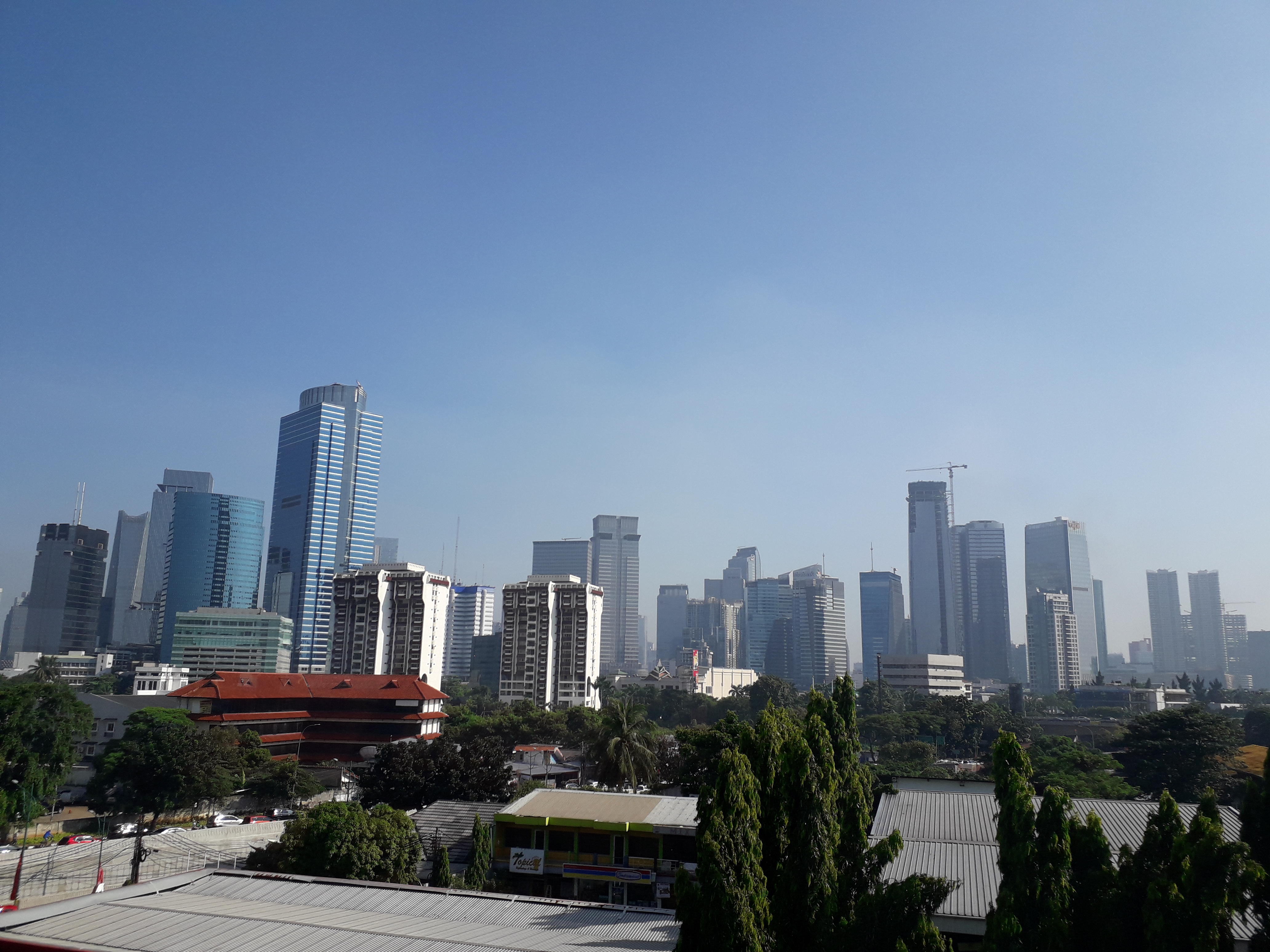
Jakarta
Skyline for Kuningan area from Transjakarta Corridor 13 (between Rawa Barat and Tendean Station).
190:
1125:
411:– If you remix, transform, or build upon the material, you must distribute your contributions under the
371:
791:
1153:
1028:
875:
122:
920:
268:
327:
1213:
1143:
1099:
927:
186:. Framing this image to focus on the copyrighted work is also a copyright violation.
109:
346:
I, the copyright holder of this work, hereby publish it under the following license:
967:
1195:
947:
812:
311:
217:
208:
199:
817:
166:
937:
910:
161:
Copyright warning: A subject in this image is protected by copyright.
748:
Click on a date/time to view the file as it appeared at that time.
313:
296:
97:
669:
306:
6° 14′ 24″ S, 106° 49′ 35″ E
135:
623:
Creative
Commons Attribution-ShareAlike 4.0 International
885:
454:
Add a one-line explanation of what this file represents
865:
840:
835:
87:(4,128 × 3,096 pixels, file size: 4.66 MB, MIME type:
243:
121:
Commons is a freely licensed media file repository.
249:Kuningan Skyline from Transjakarta Corridor 13.jpg
218:
209:
200:
422:https://creativecommons.org/licenses/by-sa/4.0
102:
428:Creative Commons Attribution-Share Alike 4.0
352:
8:
388:– to copy, distribute and transmit the work
903:
750:
450:
226:
828:The following other wikis use this file:
375:Attribution-Share Alike 4.0 International
1261:
1253:
1245:
1237:
1229:
1221:
1211:
1203:
1193:
1185:
1177:
1169:
1161:
1151:
1141:
1133:
1123:
1115:
1107:
1097:
1076:
1068:
1057:
1049:
1041:
1033:
1023:
1015:
1007:
999:
991:
983:
975:
964:
956:
945:
935:
925:
915:
810:
724:
708:
690:
674:
656:
640:
620:
604:
584:
568:
501:
485:
468:
465:
446:
439:
299:
320:View this and other nearby images on:
905:
7:
151:
798:User created page with UploadWizard
739:
363:
358:
896:
459:
453:
349:
345:
253:
158:
134:
80:
458:
146:
958:Date and time of data generation
677:coordinates of the point of view
444:
399:Under the following conditions:
370:This file is licensed under the
362:
357:
351:
326:
312:
150:
145:
139:
101:
31:
21:
441:
254:
14:
932:1/997 sec (0.0010030090270812)
440:
26:
1:
727:original creation by uploader
36:
1179:DateTimeDigitized subseconds
515:object of statement has role
466:Items portrayed in this file
1171:DateTimeOriginal subseconds
1070:Date and time of digitizing
1283:
1223:Focal length in 35 mm film
1187:Supported Flashpix version
882:Usage on uz.wikipedia.org
872:Usage on th.wikipedia.org
862:Usage on pl.wikipedia.org
847:Usage on ja.wikipedia.org
832:Usage on it.wikipedia.org
413:same or compatible license
1078:Meaning of each component
1035:File change date and time
996:45 meters above sea level
740:
278:
16:
1242:Y13LLKA00AM Y13LLKF01AA
443:
379:
108:This is a file from the
1247:GPS time (atomic clock)
1148:Center weighted average
797:
284:
274:
269:13 April 2018, 10:34:16
267:
264:
246:
112:. Information from its
692:6°14'24"S, 106°49'48"E
332:-6.240000; 106.826389
115:description page there
46:Size of this preview:
1135:Maximum land aperture
1009:Horizontal resolution
193:for more information.
1073:10:34, 13 April 2018
1038:10:34, 13 April 2018
961:10:34, 13 April 2018
776:05:35, 15 April 2018
74:4,128 × 3,096 pixels
70:2,560 × 1,920 pixels
1163:DateTime subseconds
1043:Y and C positioning
1017:Vertical resolution
907:Camera manufacturer
394:– to adapt the work
167:freedom of panorama
52:Other resolutions:
1231:Scene capture type
1218:Auto white balance
1158:Flash did not fire
543:Wikimedia username
530:author name string
191:general disclaimer
66:1,280 × 960 pixels
62:1,024 × 768 pixels
1270:
1269:
1138:1.85 APEX (f/1.9)
824:Global file usage
801:
607:copyright license
452:
337:
336:
294:
293:
236:
235:
230:
130:
129:
110:Wikimedia Commons
32:Global file usage
1274:
1051:Exposure Program
904:
788:
571:copyright status
552:
547:
537:
534:
524:
519:
435:
432:
429:
426:
423:
415:as the original.
372:Creative Commons
366:
365:
361:
360:
355:
354:
333:
330:
316:
315:
309:
308:
297:
280:
270:
258:
250:
244:
231:
154:
153:
149:
148:
143:
142:
136:
126:
105:
104:
98:
92:
90:
77:
58:640 × 480 pixels
54:320 × 240 pixels
48:800 × 600 pixels
1282:
1281:
1277:
1276:
1275:
1273:
1272:
1271:
1263:GPS tag version
1239:Unique image ID
1117:APEX brightness
892:
822:
809:
802:
794:
786:
742:
741:
738:
737:
736:
735:
734:
733:
732:
731:
729:
717:
716:
715:
713:
702:
701:
700:
699:
698:
697:
696:
695:
693:
683:
682:
681:
679:
668:
667:
666:
665:
664:
663:
662:
661:
659:
649:
648:
647:
645:
634:
633:
632:
631:
630:
629:
628:
627:
625:
613:
612:
611:
609:
598:
597:
596:
595:
594:
593:
592:
591:
589:
577:
576:
575:
573:
562:
561:
560:
559:
558:
557:
556:
555:
554:
553:
548:
545:
539:
538:
535:
532:
526:
525:
520:
517:
508:
507:
506:
504:
494:
493:
492:
490:
479:
478:
477:
476:
475:
473:
457:
456:
455:
438:
437:
436:
433:
430:
427:
424:
421:
420:
378:
367:
348:
347:
342:
331:
304:
303:
300:Camera location
295:
260:
248:
241:
232:
220:
211:
202:
198:
195:
184:will be deleted
163:
140:
132:
131:
120:
119:
118:is shown below.
94:
88:
86:
79:
78:
51:
12:
11:
5:
1280:
1278:
1268:
1267:
1264:
1260:
1259:
1256:
1252:
1251:
1248:
1244:
1243:
1240:
1236:
1235:
1232:
1228:
1227:
1224:
1220:
1219:
1216:
1210:
1209:
1206:
1202:
1201:
1198:
1192:
1191:
1188:
1184:
1183:
1180:
1176:
1175:
1172:
1168:
1167:
1164:
1160:
1159:
1156:
1150:
1149:
1146:
1140:
1139:
1136:
1132:
1131:
1128:
1122:
1121:
1118:
1114:
1113:
1110:
1106:
1105:
1102:
1096:
1095:
1094:
1093:
1092:does not exist
1090:
1087:
1084:
1079:
1075:
1074:
1071:
1067:
1066:
1063:
1056:
1055:
1054:Normal program
1052:
1048:
1047:
1044:
1040:
1039:
1036:
1032:
1031:
1026:
1022:
1021:
1018:
1014:
1013:
1010:
1006:
1005:
1002:
998:
997:
994:
990:
989:
988:106° 49′ 35″ E
986:
982:
981:
978:
974:
973:
970:
963:
962:
959:
955:
954:
951:
944:
943:
940:
934:
933:
930:
924:
923:
918:
914:
913:
908:
895:
891:
890:
889:
888:
880:
879:
878:
870:
869:
868:
860:
859:
858:
853:
845:
844:
843:
838:
826:
825:
821:
820:
815:
807:
806:
805:
800:
799:
796:
792:
789:
785:4,128 × 3,096
783:
778:
773:
769:
768:
765:
762:
759:
756:
753:
746:
745:
730:
725:
723:
722:
721:
720:
719:
718:
714:
711:source of file
709:
707:
706:
705:
704:
703:
694:
691:
689:
688:
687:
686:
685:
684:
680:
675:
673:
672:
671:
670:
660:
657:
655:
654:
653:
652:
651:
650:
646:
641:
639:
638:
637:
636:
635:
626:
621:
619:
618:
617:
616:
615:
614:
610:
605:
603:
602:
601:
600:
599:
590:
585:
583:
582:
581:
580:
579:
578:
574:
569:
567:
566:
565:
564:
563:
541:
540:
528:
527:
513:
512:
511:
510:
509:
505:
502:
500:
499:
498:
497:
496:
495:
491:
486:
484:
483:
482:
481:
480:
474:
469:
467:
464:
463:
462:
461:
460:
449:
448:
445:
442:
419:
418:
417:
416:
406:
397:
396:
395:
389:
382:You are free:
369:
368:
350:
344:
343:
341:
338:
335:
334:
324:
318:
301:
292:
291:
286:
282:
281:
276:
272:
271:
266:
262:
261:
251:
242:
240:
237:
234:
233:
197:
172:non-commercial
159:
156:
133:
128:
127:
106:
96:
95:
45:
41:
40:
39:
34:
29:
24:
19:
13:
10:
9:
6:
4:
3:
2:
1279:
1265:
1262:
1258:13 April 2018
1257:
1254:
1249:
1246:
1241:
1238:
1233:
1230:
1225:
1222:
1217:
1215:
1214:White balance
1212:
1208:Auto exposure
1207:
1205:Exposure mode
1204:
1199:
1197:
1194:
1189:
1186:
1181:
1178:
1173:
1170:
1165:
1162:
1157:
1155:
1152:
1147:
1145:
1144:Metering mode
1142:
1137:
1134:
1129:
1127:
1126:Exposure bias
1124:
1119:
1116:
1111:
1109:APEX aperture
1108:
1103:
1101:
1100:Shutter speed
1098:
1091:
1088:
1085:
1082:
1081:
1080:
1077:
1072:
1069:
1064:
1061:
1058:
1053:
1050:
1045:
1042:
1037:
1034:
1030:
1029:J330GDXU2AQK1
1027:
1025:Software used
1024:
1019:
1016:
1011:
1008:
1003:
1000:
995:
992:
987:
984:
979:
976:
971:
969:
965:
960:
957:
952:
949:
946:
941:
939:
936:
931:
929:
928:Exposure time
926:
922:
919:
916:
912:
909:
906:
902:
899:
893:
887:
884:
883:
881:
877:
874:
873:
871:
867:
864:
863:
861:
857:
854:
852:
849:
848:
846:
842:
839:
837:
834:
833:
831:
830:
829:
823:
819:
816:
814:
811:
803:
795:
790:
784:
782:
779:
777:
774:
771:
770:
766:
763:
760:
757:
754:
752:
751:
749:
743:
728:
712:
678:
658:13 April 2018
644:
624:
608:
588:
572:
551:
544:
531:
523:
516:
489:
472:
425:CC BY-SA 4.0
414:
410:
407:
404:
401:
400:
398:
393:
390:
387:
384:
383:
381:
380:
376:
373:
356:
339:
329:
325:
323:
322:OpenStreetMap
319:
317:
307:
302:
298:
290:
287:
283:
277:
273:
263:
257:
252:
245:
238:
229:
225:
221:
216:
212:
207:
203:
196:
194:
192:
187:
185:
180:
179:
177:
173:
168:
162:
157:
155:
138:
137:
124:
117:
116:
111:
107:
100:
99:
93:
84:
83:Original file
75:
71:
67:
63:
59:
55:
49:
44:
38:
35:
33:
30:
28:
25:
23:
20:
18:
15:
980:6° 14′ 24″ S
968:focal length
917:Camera model
900:
897:
856:利用者:スプリト/画像集
827:
747:
744:File history
522:photographer
408:
402:
391:
385:
255:
223:
214:
205:
188:
183:
181:
175:
171:
164:
160:
144:
123:You can help
113:
81:
22:File history
1196:Color space
1001:Orientation
851:世界の都市圏人口の順位
587:copyrighted
409:share alike
403:attribution
247:Description
886:Metropolis
813:Metropolis
804:File usage
761:Dimensions
503:some value
89:image/jpeg
27:File usage
985:Longitude
948:ISO speed
866:Indonezja
841:Setiabudi
836:Metropoli
818:Setiabudi
793:Nanami976
787:(4.66 MB)
758:Thumbnail
755:Date/Time
643:inception
550:Nanami976
536:Nanami976
340:Licensing
289:Nanami976
256:English:
210:Indonesia
1255:GPS date
1234:Standard
1046:Centered
993:Altitude
977:Latitude
938:F-number
921:SM-J330G
894:Metadata
447:Captions
392:to remix
386:to share
377:license.
279:Own work
176:personal
37:Metadata
1266:0.0.2.2
1062:version
911:samsung
772:current
767:Comment
488:creator
471:depicts
451:English
239:Summary
201:English
85:
1020:72 dpi
1012:72 dpi
1004:Normal
972:3.6 mm
950:rating
876:มหานคร
310:
285:Author
275:Source
222:
213:
204:
1250:01:33
1226:27 mm
1154:Flash
966:Lens
942:f/1.9
178:uses.
1200:sRGB
1182:0400
1174:0400
1166:0400
1120:7.92
1112:1.85
1104:9.96
1060:Exif
764:User
434:true
431:true
265:Date
17:File
1065:2.2
228:+/−
174:or
1089:Cr
1086:Cb
953:40
546::
533::
518::
219:中文
72:|
68:|
64:|
60:|
56:|
50:.
1190:1
1130:0
1083:Y
224:∙
215:∙
206:∙
125:.
91:)
76:.
Text is available under the Creative Commons Attribution-ShareAlike License. Additional terms may apply.