451:
343:
257:
249:
43:
296:
271:
457:
349:
95:
354:
797:"}},"text\/plain":{"en":{"":"heading"}}},"{\"value\":{\"amount\":\"+315\",\"unit\":\"http:\\\/\\\/www.wikidata.org\\\/entity\\\/Q28390\"},\"type\":\"quantity\"}":{"text\/html":{"en":{"P7787":"315
793:
1071:
1041:
498:– You must give appropriate credit, provide a link to the license, and indicate if changes were made. You may do so in any reasonable manner, but not in any way that suggests the licensor endorses you or your use.
402:– You must give appropriate credit, provide a link to the license, and indicate if changes were made. You may do so in any reasonable manner, but not in any way that suggests the licensor endorses you or your use.
240:
794:
313:
1170:
1310:
1240:
311:; with no Invariant Sections, no Front-Cover Texts, and no Back-Cover Texts. A copy of the license is included in the section entitled
166:
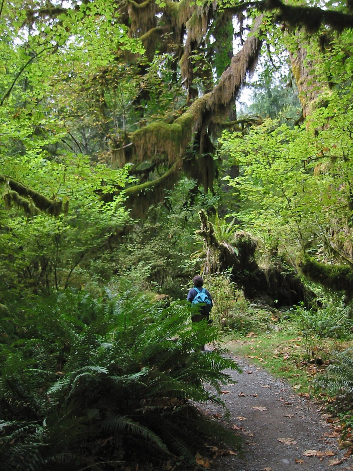
Spruce Nature Trail about 0.1 km from the Hoh Rain Forest
Visitor Center, near the end of the loop. The Hoh River Valley is located in
303:
744:
727:
710:
674:
264:
1448:
1230:
780:
1471:
1353:
This file contains additional information, probably added from the digital camera or scanner used to create or digitize it.
159:
Vine Maple (light green leaves), Sword Fern (on both sides of trail), moss covered
Bigleaf Maple limbs and roots, and hiker.
409:
61:
57:
53:
47:
1142:
106:
972:
935:
901:
864:
835:
808:
764:
658:
630:
615:
602:
308:
74:
1160:
1137:
694:
575:
558:
1250:
1100:
1095:
1070:
1065:
637:
363:
1356:
If the file has been modified from its original state, some details may not fully reflect the modified file.
1128:
The following pages on the
English Knowledge (XXG) use this file (pages on other projects are not listed):
1537:
467:
408:– If you remix, transform, or build upon the material, you must distribute your contributions under the
1375:
464:
360:
801:"}},"text\/plain":{"en":{"P7787":"315 degree"}}}}": -->
1573:
1330:
114:
1280:
622:
167:
290:
1220:
423:
301:
Permission is granted to copy, distribute and/or modify this document under the terms of the
1058:
Photoshop
Elements 4.0; 30% Auto Smart Fix, Adjust Lighting/Shadows/Highlights, Levels tools
1365:
1040:
1035:
65:
42:
1111:
1081:
1051:
270:
1563:
1519:
1382:
287:
I, the copyright holder of this work, hereby publish it under the following licenses:
101:
1411:
1180:
149:
1190:
223:
213:
1591:
254:
1132:
1392:
1340:
1200:
1008:
Click on a date/time to view the file as it appeared at that time.
1270:
241:
47° 51′ 37.44″ N, 123° 55′ 56.28″ W
256:
422:
This licensing tag was added to this file as part of the GFDL
337:
231:
89:
1300:
1290:
1260:
1320:
542:
Add a one-line explanation of what this file represents
79:(1,200 × 1,600 pixels, file size: 1.17 MB, MIME type:
728:
Creative
Commons Attribution-ShareAlike 3.0 Unported
711:
307:, Version 1.2 or any later version published by the
128:
113:
Commons is a freely licensed media file repository.
1210:
429:http://creativecommons.org/licenses/by-sa/3.0/
94:
450:
342:
8:
623:https://commons.wikimedia.org/user:Wsiegmund
435:Creative Commons Attribution-Share Alike 3.0
798:
505:https://creativecommons.org/licenses/by/2.5
481:– to copy, distribute and transmit the work
385:– to copy, distribute and transmit the work
1358:
1010:
538:
523:You may select the license of your choice.
170:, Washington, USA. USGS Owl Mountain Quad
1153:The following other wikis use this file:
1449:Adobe Photoshop Elements 4.0.1 Macintosh
1281:Biologia szkoła ponadgimnazjalna/Okładka
745:Creative Commons Attribution 2.5 Generic
1663:
1655:
1647:
1639:
1631:
1623:
1615:
1607:
1599:
1589:
1581:
1571:
1561:
1553:
1545:
1535:
1527:
1517:
1509:
1488:
1480:
1469:
1461:
1453:
1443:
1435:
1427:
1419:
1408:
1400:
1390:
1380:
1370:
1130:
986:
970:
949:
933:
915:
899:
878:
862:
822:
806:
778:
762:
742:
725:
708:
692:
672:
656:
589:
573:
556:
553:
534:
527:
234:
1181:Usuari:Anskarbot/Traduccions/Ecosystem
263:View this and other nearby images on:
1360:
194:Walter Siegmund ©2005 Walter Siegmund
7:
364:Attribution-Share Alike 3.0 Unported
319:http://www.gnu.org/copyleft/fdl.html
999:
456:
353:
348:
1351:
547:
541:
522:
472:
447:
286:
204:17 September 2005, 13:53:48 −07:00
153:
126:
72:
546:
511:Creative Commons Attribution 2.5
1402:Date and time of data generation
809:coordinates of the point of view
532:
492:Under the following conditions:
463:This file is licensed under the
455:
449:
396:Under the following conditions:
359:This file is licensed under the
352:
347:
341:
295:
294:
269:
255:
247:
93:
31:
21:
1665:Date metadata was last modified
529:
154:
14:
528:
325:GNU Free Documentation License
314:GNU Free Documentation License
304:GNU Free Documentation License
26:
1:
1143:Pacific temperate rainforests
36:
1550:2.9708557128906 APEX (f/2.8)
554:Items portrayed in this file
246:
1617:Focal plane resolution unit
1482:Date and time of digitizing
1157:Usage on blk.wikipedia.org
1138:Intercellular communication
824:47°51'37.4"N, 123°55'56.3"W
1685:
1641:Supported Flashpix version
1628:One-chip color area sensor
1583:Supported Flashpix version
1337:Usage on vi.wikipedia.org
1327:Usage on sr.wikipedia.org
1317:Usage on sq.wikipedia.org
1307:Usage on si.wikipedia.org
1297:Usage on ro.wikipedia.org
1287:Usage on pt.wikipedia.org
1277:Usage on pl.wikibooks.org
1267:Usage on nl.wikipedia.org
1257:Usage on la.wikipedia.org
1247:Usage on ja.wikipedia.org
1237:Usage on hy.wikipedia.org
1227:Usage on hi.wikipedia.org
1217:Usage on fa.wikipedia.org
1207:Usage on eu.wikipedia.org
1197:Usage on de.wikipedia.org
1187:Usage on cs.wikipedia.org
1177:Usage on ca.wikipedia.org
1167:Usage on bn.wikipedia.org
410:same or compatible license
1490:Meaning of each component
1455:File change date and time
1088:Uploaded original version
1000:
368:
340:
16:
1609:Focal plane Y resolution
1601:Focal plane X resolution
1485:13:53, 17 September 2005
1405:13:53, 17 September 2005
1201:Washington (Bundesstaat)
1096:05:46, 23 September 2005
531:
309:Free Software Foundation
100:This is a file from the
1117:
1087:
1057:
468:Attribution 2.5 Generic
219:
212:Self-published work by
208:
203:
200:
131:
104:. Information from its
1668:12:41, 4 November 2011
1511:Image compression mode
1458:19:41, 4 November 2011
1066:02:33, 5 November 2011
1036:02:45, 5 November 2011
275:47.860400; -123.932300
134:HohRiverTrail 7322.jpg
107:description page there
46:Size of this preview:
1547:Maximum land aperture
1429:Horizontal resolution
1271:Olympic National Park
1191:Pacifické deštné lesy
168:Olympic National Park
1636:Digital still camera
1376:Canon PowerShot S110
781:Canon PowerShot S110
188:Canon PowerShot S110
174:Viewpoint elevation:
66:1,200 × 1,600 pixels
1463:Y and C positioning
1437:Vertical resolution
1387:1/160 sec (0.00625)
1362:Camera manufacturer
487:– to adapt the work
391:– to adapt the work
164:Viewpoint location:
140:Spruce Nature Trail
52:Other resolutions:
1578:Flash did not fire
631:Wikimedia username
603:author name string
1672:
1671:
1149:Global file usage
1121:
800:
695:copyright license
540:
446:
445:
336:
335:
280:
279:
229:
228:
122:
121:
102:Wikimedia Commons
32:Global file usage
1676:
1604:7,766.9902912621
1555:Subject distance
1359:
1241:Աշխարհագրություն
1108:
1078:
1048:
954:
883:
846:
845:
840:
659:copyright status
640:
635:
625:
620:
610:
607:
518:
515:
512:
509:
506:
465:Creative Commons
459:
458:
453:
452:
442:
439:
436:
433:
430:
427:
424:licensing update
412:as the original.
361:Creative Commons
356:
355:
351:
350:
345:
344:
338:
332:
329:
326:
323:
320:
298:
297:
291:
276:
273:
259:
258:
252:
251:
250:
244:
243:
232:
158:
135:
129:
118:
97:
96:
90:
84:
82:
69:
62:576 × 768 pixels
58:360 × 480 pixels
54:180 × 240 pixels
48:450 × 600 pixels
1684:
1683:
1679:
1678:
1677:
1675:
1674:
1673:
1612:7,741.935483871
1347:
1147:
1129:
1122:
1114:
1106:
1084:
1076:
1054:
1046:
1002:
1001:
998:
997:
996:
995:
994:
993:
992:
991:
989:
979:
978:
977:
975:
964:
963:
962:
961:
960:
959:
958:
957:
955:
952:
942:
941:
940:
938:
927:
926:
925:
924:
923:
922:
921:
920:
918:
908:
907:
906:
904:
893:
892:
891:
890:
889:
888:
887:
886:
884:
881:
871:
870:
869:
867:
856:
855:
854:
853:
852:
851:
850:
849:
848:
847:
843:
841:
838:
829:
828:
827:
825:
815:
814:
813:
811:
792:
791:
790:
789:
788:
787:
786:
785:
783:
771:
770:
769:
767:
756:
755:
754:
753:
752:
751:
750:
749:
747:
736:
735:
734:
733:
732:
730:
719:
718:
717:
716:
715:
713:
701:
700:
699:
697:
686:
685:
684:
683:
682:
681:
680:
679:
677:
665:
664:
663:
661:
650:
649:
648:
647:
646:
645:
644:
643:
642:
641:
636:
633:
627:
626:
621:
618:
612:
611:
608:
605:
596:
595:
594:
592:
582:
581:
580:
578:
567:
566:
565:
564:
563:
561:
545:
544:
543:
526:
525:
524:
520:
519:
516:
513:
510:
507:
504:
503:
471:
460:
440:
437:
434:
431:
428:
421:
330:
327:
324:
321:
318:
289:
288:
274:
248:
239:
238:
235:Camera location
230:
180:View direction:
160:
150:Acer circinatum
133:
124:
123:
112:
111:
110:is shown below.
86:
80:
78:
71:
70:
51:
12:
11:
5:
1682:
1680:
1670:
1669:
1666:
1662:
1661:
1658:
1654:
1653:
1650:
1646:
1645:
1642:
1638:
1637:
1634:
1630:
1629:
1626:
1625:Sensing method
1622:
1621:
1618:
1614:
1613:
1610:
1606:
1605:
1602:
1598:
1597:
1594:
1588:
1587:
1584:
1580:
1579:
1576:
1570:
1569:
1566:
1560:
1559:
1556:
1552:
1551:
1548:
1544:
1543:
1540:
1534:
1533:
1530:
1526:
1525:
1522:
1516:
1515:
1512:
1508:
1507:
1506:
1505:
1504:does not exist
1502:
1499:
1496:
1491:
1487:
1486:
1483:
1479:
1478:
1475:
1468:
1467:
1464:
1460:
1459:
1456:
1452:
1451:
1446:
1442:
1441:
1438:
1434:
1433:
1430:
1426:
1425:
1422:
1418:
1417:
1414:
1407:
1406:
1403:
1399:
1398:
1395:
1389:
1388:
1385:
1379:
1378:
1373:
1369:
1368:
1363:
1350:
1346:
1345:
1344:
1343:
1335:
1334:
1333:
1325:
1324:
1323:
1315:
1314:
1313:
1305:
1304:
1303:
1295:
1294:
1293:
1285:
1284:
1283:
1275:
1274:
1273:
1265:
1264:
1263:
1255:
1254:
1253:
1245:
1244:
1243:
1235:
1234:
1233:
1225:
1224:
1223:
1215:
1214:
1213:
1205:
1204:
1203:
1195:
1194:
1193:
1185:
1184:
1183:
1175:
1174:
1173:
1165:
1164:
1163:
1151:
1150:
1146:
1145:
1140:
1135:
1127:
1126:
1125:
1120:
1119:
1116:
1112:
1109:
1103:
1098:
1093:
1090:
1089:
1086:
1082:
1079:
1075:1,200 × 1,600
1073:
1068:
1063:
1060:
1059:
1056:
1052:
1049:
1045:1,200 × 1,600
1043:
1038:
1033:
1029:
1028:
1025:
1022:
1019:
1016:
1013:
1006:
1005:
990:
987:
985:
984:
983:
982:
981:
980:
976:
971:
969:
968:
967:
966:
965:
956:
950:
948:
947:
946:
945:
944:
943:
939:
934:
932:
931:
930:
929:
928:
919:
916:
914:
913:
912:
911:
910:
909:
905:
900:
898:
897:
896:
895:
894:
885:
879:
877:
876:
875:
874:
873:
872:
868:
863:
861:
860:
859:
858:
857:
834:
833:
832:
831:
830:
826:
823:
821:
820:
819:
818:
817:
816:
812:
807:
805:
804:
803:
802:
796:
784:
779:
777:
776:
775:
774:
773:
772:
768:
763:
761:
760:
759:
758:
757:
748:
743:
741:
740:
739:
738:
737:
731:
726:
724:
723:
722:
721:
720:
714:
709:
707:
706:
705:
704:
703:
702:
698:
693:
691:
690:
689:
688:
687:
678:
673:
671:
670:
669:
668:
667:
666:
662:
657:
655:
654:
653:
652:
651:
629:
628:
614:
613:
601:
600:
599:
598:
597:
593:
590:
588:
587:
586:
585:
584:
583:
579:
574:
572:
571:
570:
569:
568:
562:
557:
555:
552:
551:
550:
549:
548:
537:
536:
533:
530:
521:
502:
501:
500:
499:
490:
489:
488:
482:
475:You are free:
462:
461:
448:
444:
443:
418:
417:
416:
415:
414:
413:
403:
394:
393:
392:
386:
379:You are free:
374:
373:
370:
369:
367:
357:
334:
333:
299:
285:
284:
282:(WGS84/NAD83)
278:
277:
267:
261:
236:
227:
226:
221:
217:
216:
210:
206:
205:
202:
198:
197:
196:
195:
189:
183:
177:
171:
161:
136:
127:
125:
120:
119:
98:
88:
87:
45:
41:
40:
39:
34:
29:
24:
19:
13:
10:
9:
6:
4:
3:
2:
1681:
1667:
1664:
1659:
1656:
1651:
1648:
1643:
1640:
1635:
1632:
1627:
1624:
1619:
1616:
1611:
1608:
1603:
1600:
1595:
1593:
1590:
1585:
1582:
1577:
1575:
1572:
1567:
1565:
1564:Metering mode
1562:
1557:
1554:
1549:
1546:
1541:
1539:
1538:Exposure bias
1536:
1531:
1529:APEX aperture
1528:
1523:
1521:
1520:Shutter speed
1518:
1513:
1510:
1503:
1500:
1497:
1494:
1493:
1492:
1489:
1484:
1481:
1476:
1473:
1470:
1465:
1462:
1457:
1454:
1450:
1447:
1445:Software used
1444:
1439:
1436:
1431:
1428:
1423:
1420:
1415:
1413:
1409:
1404:
1401:
1396:
1394:
1391:
1386:
1384:
1383:Exposure time
1381:
1377:
1374:
1371:
1367:
1364:
1361:
1357:
1354:
1348:
1342:
1339:
1338:
1336:
1332:
1329:
1328:
1326:
1322:
1319:
1318:
1316:
1312:
1309:
1308:
1306:
1302:
1299:
1298:
1296:
1292:
1289:
1288:
1286:
1282:
1279:
1278:
1276:
1272:
1269:
1268:
1266:
1262:
1259:
1258:
1256:
1252:
1249:
1248:
1246:
1242:
1239:
1238:
1236:
1232:
1229:
1228:
1226:
1222:
1219:
1218:
1216:
1212:
1209:
1208:
1206:
1202:
1199:
1198:
1196:
1192:
1189:
1188:
1186:
1182:
1179:
1178:
1176:
1172:
1169:
1168:
1166:
1162:
1159:
1158:
1156:
1155:
1154:
1148:
1144:
1141:
1139:
1136:
1134:
1131:
1123:
1115:
1110:
1104:
1102:
1099:
1097:
1094:
1092:
1091:
1085:
1080:
1074:
1072:
1069:
1067:
1064:
1062:
1061:
1055:
1050:
1044:
1042:
1039:
1037:
1034:
1031:
1030:
1026:
1023:
1020:
1017:
1014:
1012:
1011:
1009:
1003:
974:
937:
903:
866:
865:exposure time
837:
810:
782:
766:
765:captured with
746:
729:
712:
696:
676:
660:
639:
632:
624:
617:
604:
577:
560:
497:
494:
493:
491:
486:
483:
480:
477:
476:
474:
473:
469:
466:
454:
425:
420:
419:
411:
407:
404:
401:
398:
397:
395:
390:
387:
384:
381:
380:
378:
377:
376:
375:
372:
371:
365:
362:
358:
346:
339:
316:
315:
310:
306:
305:
300:
293:
292:
283:
272:
268:
266:
265:OpenStreetMap
262:
260:
242:
237:
233:
225:
222:
218:
215:
211:
207:
199:
193:
192:Photographer:
190:
187:
184:
181:
178:
175:
172:
169:
165:
162:
157:
152:
151:
147:
144:
143:
142:
141:
137:
130:
116:
109:
108:
103:
99:
92:
91:
85:
76:
75:Original file
67:
63:
59:
55:
49:
44:
38:
35:
33:
30:
28:
25:
23:
20:
18:
15:
1657:Image height
1558:1.003 meters
1412:focal length
1372:Camera model
1355:
1352:
1341:Hệ sinh thái
1311:පරිසර පද්ධති
1171:বাস্তুতন্ত্র
1152:
1007:
1004:File history
936:focal length
495:
484:
478:
432:CC BY-SA 3.0
405:
399:
388:
382:
312:
302:
281:
245:
191:
185:
179:
173:
163:
155:
148:
146:Description:
145:
139:
138:
115:You can help
105:
73:
22:File history
1649:Image width
1633:File source
1592:Color space
1421:Orientation
1291:Ecossistema
1261:Oecosystema
675:copyrighted
496:attribution
406:share alike
400:attribution
132:Description
1416:5.40625 mm
1321:Ekosistemi
1124:File usage
1105:600 × 800
1021:Dimensions
988:image/jpeg
973:media type
953:millimetre
591:some value
508:CC BY 2.5
182:Northwest.
81:image/jpeg
27:File usage
1331:Екосистем
1231:पारितंत्र
1133:Ecosystem
1113:Wsiegmund
1083:Wsiegmund
1053:Wsiegmund
1047:(1.17 MB)
1018:Thumbnail
1015:Date/Time
638:Wsiegmund
609:Wsiegmund
366:license.
224:Wsiegmund
214:Wsiegmund
156:English:
1660:1,600 px
1652:1,200 px
1466:Centered
1393:F-number
1349:Metadata
1251:オリンピック半島
1221:اکوسیستم
1161:ဂေဟစနိစ်
1107:(292 KB)
1077:(870 KB)
951:5.40625
902:f-number
880:0.00625
535:Captions
485:to remix
479:to share
470:license.
389:to remix
383:to share
37:Metadata
1568:Pattern
1532:2.96875
1474:version
1440:180 dpi
1432:180 dpi
1032:current
1027:Comment
836:heading
795:heading
576:creator
559:depicts
539:English
186:Camera:
77:
1620:inches
1524:7.3125
1424:Normal
1301:Natură
882:second
844:degree
799:degree
253:
220:Author
209:Source
1574:Flash
1410:Lens
1397:f/2.8
1366:Canon
176:560'+
1596:sRGB
1472:Exif
1211:Bizi
1024:User
842:315
517:true
514:true
441:true
438:true
331:true
328:true
322:GFDL
201:Date
17:File
1477:2.1
917:2.8
616:URL
1542:−1
1501:Cr
1498:Cb
839::
634::
619::
606::
64:|
60:|
56:|
50:.
1644:1
1586:1
1514:3
1495:Y
426:.
317:.
117:.
83:)
68:.
Text is available under the Creative Commons Attribution-ShareAlike License. Additional terms may apply.