129:
248:
209:
223:
254:
259:
67:
731:
300:– You must give appropriate credit, provide a link to the license, and indicate if changes were made. You may do so in any reasonable manner, but not in any way that suggests the licensor endorses you or your use.
38:
200:
78:
46:
136:
572:
536:
500:
216:
809:
381:
642:
307:
662:
626:
556:
484:
458:
443:
428:
592:
520:
401:
365:
435:
761:
269:
730:
725:
37:
757:
The following pages on the
English Knowledge (XXG) use this file (pages on other projects are not listed):
306:– If you remix, transform, or build upon the material, you must distribute your contributions under the
266:
804:
121:
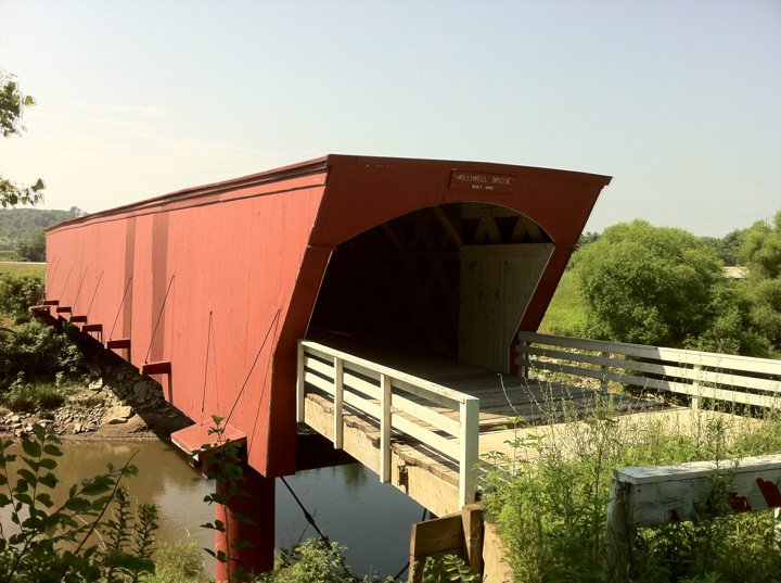
This is a photograph of the
Holliwel Covered bridge in Madison County, Iowa taken on 16 July 2011
86:
450:
794:
741:
222:
145:
73:
241:
I, the copyright holder of this work, hereby publish it under the following license:
183:
206:
163:
123:
779:
789:
698:
Click on a date/time to view the file as it appeared at that time.
140:
655:
208:
201:
41° 19′ 22.12″ N, 93° 57′ 33.7″ W
191:
135:
This is an image of a place or building that is listed on the
61:
349:
Add a one-line explanation of what this file represents
819:
537:
Creative
Commons Attribution-ShareAlike 3.0 Unported
105:
85:
Commons is a freely licensed media file repository.
51:(720 × 537 pixels, file size: 85 KB, MIME type:
317:https://creativecommons.org/licenses/by-sa/3.0
66:
323:Creative Commons Attribution-Share Alike 3.0
247:
8:
795:Liste des ponts couverts du comté de Madison
451:https://commons.wikimedia.org/user:Lexandalf
283:– to copy, distribute and transmit the work
700:
345:
772:The following other wikis use this file:
111:Holliwell Covered bridge 16 July 2011.jpg
47:Holliwell_Covered_bridge_16_July_2011.jpg
759:
676:
660:
640:
624:
606:
590:
570:
554:
534:
518:
498:
482:
415:
399:
379:
363:
360:
341:
334:
194:
215:View this and other nearby images on:
7:
270:Attribution-Share Alike 3.0 Unported
137:National Register of Historic Places
689:
258:
253:
354:
348:
244:
240:
115:
98:
44:
353:
339:
294:Under the following conditions:
265:This file is licensed under the
257:
252:
246:
221:
207:
127:
65:
31:
21:
336:
116:
41:No higher resolution available.
14:
335:
26:
1:
663:coordinates of depicted place
573:original creation by uploader
678:41°19'22.12"N, 93°57'33.70"W
361:Items portrayed in this file
838:
816:Usage on www.wikidata.org
801:Usage on ja.wikipedia.org
786:Usage on fr.wikipedia.org
776:Usage on es.wikipedia.org
308:same or compatible license
143:. Its reference number is
780:Puente cubierto Holliwell
690:
173:
16:
762:Holliwell Covered Bridge
382:Holliwell Covered Bridge
338:
274:
141:United States of America
72:This is a file from the
747:
179:
169:
162:
159:
108:
76:. Information from its
790:Pont couvert Holliwell
227:41.322810; -93.959360
79:description page there
627:location of creation
726:22:24, 20 June 2012
289:– to adapt the work
459:author name string
429:Wikimedia username
768:Global file usage
750:
521:copyright license
347:
232:
231:
189:
188:
155:
154:
94:
93:
74:Wikimedia Commons
32:Global file usage
829:
738:
485:copyright status
466:
463:
453:
448:
438:
433:
330:
327:
324:
321:
318:
310:as the original.
267:Creative Commons
261:
260:
256:
255:
250:
249:
228:
225:
211:
210:
204:
203:
192:
175:
165:
148:
131:
130:
124:
120:
112:
106:
90:
69:
68:
62:
56:
54:
837:
836:
832:
831:
830:
828:
827:
826:
766:
758:
751:
744:
736:
692:
691:
688:
687:
686:
685:
684:
683:
682:
681:
679:
669:
668:
667:
665:
654:
653:
652:
651:
650:
649:
648:
647:
645:
633:
632:
631:
629:
618:
617:
616:
615:
614:
613:
612:
611:
609:
599:
598:
597:
595:
584:
583:
582:
581:
580:
579:
578:
577:
575:
563:
562:
561:
559:
548:
547:
546:
545:
544:
543:
542:
541:
539:
527:
526:
525:
523:
512:
511:
510:
509:
508:
507:
506:
505:
503:
491:
490:
489:
487:
476:
475:
474:
473:
472:
471:
470:
469:
468:
467:
464:
461:
455:
454:
449:
446:
440:
439:
434:
431:
422:
421:
420:
418:
408:
407:
406:
404:
393:
392:
391:
390:
389:
388:
387:
386:
384:
372:
371:
370:
368:
352:
351:
350:
333:
332:
331:
328:
325:
322:
319:
316:
315:
273:
262:
243:
242:
237:
226:
199:
198:
195:Object location
190:
144:
128:
122:
110:
103:
96:
95:
84:
83:
82:is shown below.
58:
52:
50:
43:
42:
12:
11:
5:
835:
833:
825:
824:
823:
822:
814:
813:
812:
807:
799:
798:
797:
792:
784:
783:
782:
770:
769:
765:
764:
756:
755:
754:
749:
748:
746:
742:
739:
733:
728:
723:
719:
718:
715:
712:
709:
706:
703:
696:
695:
680:
677:
675:
674:
673:
672:
671:
670:
666:
661:
659:
658:
657:
656:
646:
641:
639:
638:
637:
636:
635:
634:
630:
625:
623:
622:
621:
620:
619:
610:
607:
605:
604:
603:
602:
601:
600:
596:
591:
589:
588:
587:
586:
585:
576:
571:
569:
568:
567:
566:
565:
564:
560:
557:source of file
555:
553:
552:
551:
550:
549:
540:
535:
533:
532:
531:
530:
529:
528:
524:
519:
517:
516:
515:
514:
513:
504:
499:
497:
496:
495:
494:
493:
492:
488:
483:
481:
480:
479:
478:
477:
457:
456:
442:
441:
427:
426:
425:
424:
423:
419:
416:
414:
413:
412:
411:
410:
409:
405:
400:
398:
397:
396:
395:
394:
385:
380:
378:
377:
376:
375:
374:
373:
369:
364:
362:
359:
358:
357:
356:
355:
344:
343:
340:
337:
314:
313:
312:
311:
301:
292:
291:
290:
284:
277:You are free:
264:
263:
245:
239:
238:
236:
233:
230:
229:
219:
213:
196:
187:
186:
181:
177:
176:
171:
167:
166:
161:
157:
156:
153:
152:
132:
113:
104:
102:
99:
97:
92:
91:
70:
60:
59:
40:
36:
35:
34:
29:
24:
19:
13:
10:
9:
6:
4:
3:
2:
834:
821:
818:
817:
815:
811:
808:
806:
803:
802:
800:
796:
793:
791:
788:
787:
785:
781:
778:
777:
775:
774:
773:
767:
763:
760:
752:
745:
740:
734:
732:
729:
727:
724:
721:
720:
716:
713:
710:
707:
704:
702:
701:
699:
693:
664:
644:
628:
594:
574:
558:
538:
522:
502:
486:
460:
452:
445:
437:
430:
403:
383:
367:
320:CC BY-SA 3.0
309:
305:
302:
299:
296:
295:
293:
288:
285:
282:
279:
278:
276:
275:
271:
268:
251:
234:
224:
220:
218:
217:OpenStreetMap
214:
212:
202:
197:
193:
185:
182:
178:
172:
168:
158:
151:
150:
147:
142:
138:
133:
126:
125:
119:
114:
107:
100:
88:
81:
80:
75:
71:
64:
63:
57:
48:
39:
33:
30:
28:
25:
23:
20:
18:
15:
771:
697:
694:File history
608:16 July 2011
303:
297:
286:
280:
164:16 July 2011
134:
117:
87:You can help
77:
45:
22:File history
501:copyrighted
304:share alike
298:attribution
109:Description
753:File usage
735:720 × 537
711:Dimensions
417:some value
53:image/jpeg
27:File usage
810:ホグバック屋根付橋
743:Lexandalf
708:Thumbnail
705:Date/Time
643:Winterset
593:inception
465:Lexandalf
436:Lexandalf
235:Licensing
184:Lexandalf
118:English:
820:Q1624852
342:Captions
287:to remix
281:to share
272:license.
174:Own work
146:76000789
737:(85 KB)
722:current
717:Comment
402:creator
366:depicts
346:English
139:in the
101:Summary
49:
805:ホリウェル橋
205:
180:Author
170:Source
714:User
329:true
326:true
160:Date
17:File
444:URL
462::
447::
432::
149:.
89:.
55:)
Text is available under the Creative Commons Attribution-ShareAlike License. Additional terms may apply.