259:
220:
43:
234:
265:
270:
103:
687:
311:– You must give appropriate credit, provide a link to the license, and indicate if changes were made. You may do so in any reasonable manner, but not in any way that suggests the licensor endorses you or your use.
211:
801:
948:
632:
528:
492:
227:
69:
65:
61:
57:
53:
47:
157:
charnockitischer
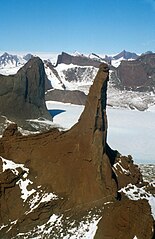
Felspfeiler in der nördlichen Holtedahlfjella, Dronning Maud Land, fotografiert aus der Luft in SSE-Richtung
114:
854:
This file contains additional information, probably added from the digital camera or scanner used to create or digitize it.
318:
82:
165:
charnockitic rock needle, northern
Holtedahlfjella (Kurze Mountains), Queen Maud Land, aerial photograph in SSE direction.
616:
582:
476:
450:
435:
420:
741:
548:
512:
393:
376:
280:
442:
857:
If the file has been modified from its original state, some details may not fully reflect the modified file.
714:
The following pages on the
English Knowledge (XXG) use this file (pages on other projects are not listed):
317:– If you remix, transform, or build upon the material, you must distribute your contributions under the
277:
122:
427:
723:
718:
686:
681:
73:
42:
233:
109:
252:
I, the copyright holder of this work, hereby publish it under the following license:
831:
963:
697:
174:
217:
194:
781:
654:
Click on a date/time to view the file as it appeared at that time.
219:
212:
71° 28′ 26.4″ S, 11° 29′ 40.56″ E
575:
202:
97:
751:
821:
811:
771:
761:
791:
360:
Add a one-line explanation of what this file represents
87:(2,681 × 4,134 pixels, file size: 2.77 MB, MIME type:
841:
529:
Creative
Commons Attribution-ShareAlike 3.0 Unported
141:
121:
Commons is a freely licensed media file repository.
328:https://creativecommons.org/licenses/by-sa/3.0
102:
334:Creative Commons Attribution-Share Alike 3.0
258:
8:
294:– to copy, distribute and transmit the work
859:
656:
356:
734:The following other wikis use this file:
428:https://commons.wikimedia.org/user:Diorit
995:
987:
979:
971:
961:
953:
943:
935:
927:
919:
911:
903:
895:
877:
869:
861:
716:
630:
614:
596:
580:
562:
546:
526:
510:
490:
474:
407:
391:
374:
371:
352:
345:
205:
226:View this and other nearby images on:
7:
949:Adobe Photoshop Elements 6.0 Windows
281:Attribution-Share Alike 3.0 Unported
704:User created page with UploadWizard
645:
269:
264:
852:
365:
359:
255:
251:
159:
151:
134:
80:
364:
583:coordinates of the point of view
350:
305:Under the following conditions:
276:This file is licensed under the
268:
263:
257:
232:
218:
101:
31:
21:
997:Date metadata was last modified
347:
160:
14:
346:
152:
26:
1:
633:original creation by uploader
36:
372:Items portrayed in this file
989:Date and time of digitizing
748:Usage on ceb.wikipedia.org
1017:
838:Usage on www.wikidata.org
828:Usage on vi.wikipedia.org
818:Usage on no.wikipedia.org
808:Usage on nn.wikipedia.org
798:Usage on mk.wikipedia.org
788:Usage on it.wikipedia.org
778:Usage on fr.wikipedia.org
768:Usage on es.wikipedia.org
758:Usage on de.wikipedia.org
738:Usage on ar.wikipedia.org
598:71°28'26.4"S, 11°29'40.6"E
319:same or compatible license
955:File change date and time
646:
184:
16:
782:Wikipédia:RAW/2019-06-01
349:
285:
147:Holtedahlfjella Nord.jpg
108:This is a file from the
703:
238:-71.474000; 11.494600
190:
180:
173:
170:
144:
112:. Information from its
802:Земја на Кралицата Мод
115:description page there
46:Size of this preview:
929:Horizontal resolution
1000:18:46, 1 August 2011
992:18:46, 1 August 2011
958:15:46, 1 August 2011
921:Number of components
74:2,681 × 4,134 pixels
70:1,328 × 2,048 pixels
937:Vertical resolution
832:Vùng đất Queen Maud
300:– to adapt the work
52:Other resolutions:
897:Compression scheme
879:Bits per component
451:author name string
436:Wikimedia username
66:664 × 1,024 pixels
1004:
1003:
905:Pixel composition
730:Global file usage
707:
682:10:31, 2 May 2014
513:copyright license
358:
243:
242:
200:
199:
130:
129:
110:Wikimedia Commons
32:Global file usage
1008:
860:
694:
477:copyright status
458:
455:
445:
440:
430:
425:
341:
338:
335:
332:
329:
321:as the original.
278:Creative Commons
272:
271:
267:
266:
261:
260:
239:
236:
222:
221:
215:
214:
203:
186:
176:
164:
156:
148:
142:
126:
105:
104:
98:
92:
90:
77:
62:498 × 768 pixels
58:311 × 480 pixels
54:155 × 240 pixels
48:389 × 600 pixels
1016:
1015:
1011:
1010:
1009:
1007:
1006:
1005:
848:
822:Holtedahlfjella
812:Holtedahlfjella
772:Holtedahlfjella
752:Holtedahlfjella
728:
724:Queen Maud Land
719:Kurze Mountains
715:
708:
700:
692:
648:
647:
644:
643:
642:
641:
640:
639:
638:
637:
635:
623:
622:
621:
619:
608:
607:
606:
605:
604:
603:
602:
601:
599:
589:
588:
587:
585:
574:
573:
572:
571:
570:
569:
568:
567:
565:
555:
554:
553:
551:
540:
539:
538:
537:
536:
535:
534:
533:
531:
519:
518:
517:
515:
504:
503:
502:
501:
500:
499:
498:
497:
495:
483:
482:
481:
479:
468:
467:
466:
465:
464:
463:
462:
461:
460:
459:
456:
453:
447:
446:
441:
438:
432:
431:
426:
423:
414:
413:
412:
410:
400:
399:
398:
396:
385:
384:
383:
382:
381:
379:
363:
362:
361:
344:
343:
342:
339:
336:
333:
330:
327:
326:
284:
273:
254:
253:
248:
237:
210:
209:
206:Camera location
201:
166:
158:
146:
139:
132:
131:
120:
119:
118:is shown below.
94:
88:
86:
79:
78:
51:
12:
11:
5:
1014:
1012:
1002:
1001:
998:
994:
993:
990:
986:
985:
982:
978:
977:
974:
970:
969:
966:
960:
959:
956:
952:
951:
946:
942:
941:
938:
934:
933:
930:
926:
925:
922:
918:
917:
914:
910:
909:
906:
902:
901:
898:
894:
893:
892:
891:
888:
885:
880:
876:
875:
872:
868:
867:
864:
851:
847:
846:
845:
844:
836:
835:
834:
826:
825:
824:
816:
815:
814:
806:
805:
804:
796:
795:
794:
786:
785:
784:
776:
775:
774:
766:
765:
764:
756:
755:
754:
746:
745:
744:
742:أرض الملكة مود
732:
731:
727:
726:
721:
713:
712:
711:
706:
705:
702:
698:
695:
691:2,681 × 4,134
689:
684:
679:
675:
674:
671:
668:
665:
662:
659:
652:
651:
636:
631:
629:
628:
627:
626:
625:
624:
620:
617:source of file
615:
613:
612:
611:
610:
609:
600:
597:
595:
594:
593:
592:
591:
590:
586:
581:
579:
578:
577:
576:
566:
564:5 January 1996
563:
561:
560:
559:
558:
557:
556:
552:
547:
545:
544:
543:
542:
541:
532:
527:
525:
524:
523:
522:
521:
520:
516:
511:
509:
508:
507:
506:
505:
496:
491:
489:
488:
487:
486:
485:
484:
480:
475:
473:
472:
471:
470:
469:
457:Wilfried Bauer
449:
448:
434:
433:
419:
418:
417:
416:
415:
411:
408:
406:
405:
404:
403:
402:
401:
397:
392:
390:
389:
388:
387:
386:
380:
375:
373:
370:
369:
368:
367:
366:
355:
354:
351:
348:
325:
324:
323:
322:
312:
303:
302:
301:
295:
288:You are free:
275:
274:
256:
250:
249:
247:
244:
241:
240:
230:
224:
207:
198:
197:
195:Wilfried Bauer
192:
188:
187:
182:
178:
177:
175:5 January 1996
172:
168:
167:
149:
140:
138:
135:
133:
128:
127:
106:
96:
95:
45:
41:
40:
39:
34:
29:
24:
19:
13:
10:
9:
6:
4:
3:
2:
1013:
999:
996:
991:
988:
983:
980:
975:
972:
967:
965:
962:
957:
954:
950:
947:
945:Software used
944:
939:
936:
931:
928:
923:
920:
915:
912:
907:
904:
899:
896:
889:
886:
883:
882:
881:
878:
873:
870:
865:
862:
858:
855:
849:
843:
840:
839:
837:
833:
830:
829:
827:
823:
820:
819:
817:
813:
810:
809:
807:
803:
800:
799:
797:
793:
790:
789:
787:
783:
780:
779:
777:
773:
770:
769:
767:
763:
760:
759:
757:
753:
750:
749:
747:
743:
740:
739:
737:
736:
735:
729:
725:
722:
720:
717:
709:
701:
696:
690:
688:
685:
683:
680:
677:
676:
672:
669:
666:
663:
660:
658:
657:
655:
649:
634:
618:
584:
550:
530:
514:
494:
478:
452:
444:
437:
429:
422:
395:
378:
331:CC BY-SA 3.0
320:
316:
313:
310:
307:
306:
304:
299:
296:
293:
290:
289:
287:
286:
282:
279:
262:
245:
235:
231:
229:
228:OpenStreetMap
225:
223:
213:
208:
204:
196:
193:
189:
183:
179:
169:
163:
155:
150:
143:
136:
124:
117:
116:
111:
107:
100:
99:
93:
84:
83:Original file
75:
71:
67:
63:
59:
55:
49:
44:
38:
35:
33:
30:
28:
25:
23:
20:
18:
15:
981:Image height
968:Uncalibrated
940:118.1102 dpc
932:118.1102 dpc
900:Uncompressed
856:
853:
762:Kurzegebirge
733:
653:
650:File history
314:
308:
297:
291:
161:
153:
123:You can help
113:
81:
22:File history
973:Image width
964:Color space
913:Orientation
792:Monti Kurze
493:copyrighted
315:share alike
309:attribution
145:Description
710:File usage
667:Dimensions
409:some value
89:image/jpeg
27:File usage
693:(2.77 MB)
664:Thumbnail
661:Date/Time
549:inception
246:Licensing
162:English:
154:Deutsch:
984:4,134 px
976:2,681 px
874:4,134 px
866:2,681 px
850:Metadata
842:Q3428275
353:Captions
298:to remix
292:to share
283:license.
185:Own work
37:Metadata
678:current
673:Comment
394:creator
377:depicts
357:English
137:Summary
85:
916:Normal
871:Height
699:Diorit
443:Diorit
216:
191:Author
181:Source
863:Width
670:User
340:true
337:true
171:Date
17:File
908:RGB
421:URL
454::
439::
424::
72:|
68:|
64:|
60:|
56:|
50:.
924:3
890:8
887:8
884:8
125:.
91:)
76:.
Text is available under the Creative Commons Attribution-ShareAlike License. Additional terms may apply.
