290:
225:
239:
258:
296:
301:
82:
38:
856:
348:– You must give appropriate credit, provide a link to the license, and indicate if changes were made. You may do so in any reasonable manner, but not in any way that suggests the licensor endorses you or your use.
916:
216:
873:{{Information |Description={{en|Hood Monument, Compton Dundon, Somerset.}} |Source=Transferred from |Date=2008-03-23 (original upload date) |Author=Original uploader was
896:
194:
646:
610:
574:
232:
801:
681:
455:
901:
265:
355:
524:
906:
785:
717:
689:
630:
558:
532:
517:
502:
751:
674:
659:
594:
475:
439:
252:
48:
42:
311:
93:
944:
61:
887:
The following pages on the
English Knowledge (XXG) use this file (pages on other projects are not listed):
891:
354:– If you remix, transform, or build upon the material, you must distribute your contributions under the
272:
on the
Geograph website for the photographer's contact details. The copyright on this image is owned by
308:
125:
934:
101:
120:
696:
666:
509:
911:
238:
277:
88:
855:
850:
52:
37:
866:
399:
222:
874:
162:
183:
173:
257:
974:
269:
984:
823:
Click on a date/time to view the file as it appeared at that time.
224:
217:
51° 06′ 04.57″ N, 2° 43′ 21.43″ W
964:
710:
207:
76:
954:
917:
Template:English
Heritage listed building row/testcases
423:
Add a one-line explanation of what this file represents
391:
994:
201:
Creative
Commons Attribution Share-alike license 2.0
137:
114:
100:
Commons is a freely licensed media file repository.
611:
Creative
Commons Attribution-ShareAlike 2.0 Generic
394:. All following user names refer to en.wikipedia.
66:(533 × 640 pixels, file size: 221 KB, MIME type:
365:https://creativecommons.org/licenses/by-sa/2.0
81:
371:Creative Commons Attribution-Share Alike 2.0
289:
8:
897:Grade II* listed buildings in South Somerset
404:{{subst:geograph | 107630 | Patrick Mackie}}
331:– to copy, distribute and transmit the work
825:
419:
927:The following other wikis use this file:
667:https://www.geograph.org.uk/photo/107630
510:https://www.geograph.org.uk/profile/2208
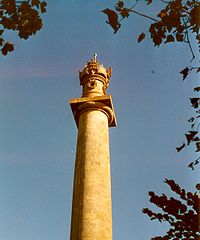
153:Hood Monument, Compton Dundon, Somerset.
889:
799:
783:
765:
749:
731:
715:
644:
628:
608:
592:
572:
556:
489:
473:
453:
437:
434:
415:
408:
210:
231:View this and other nearby images on:
7:
276:and is licensed for reuse under the
814:
312:Attribution-Share Alike 2.0 Generic
300:
295:
280:Attribution-ShareAlike 2.0 license.
428:
422:
390:The original description page was
389:
286:
263:
147:
118:
113:
59:
427:
718:coordinates of the point of view
413:
342:Under the following conditions:
307:This file is licensed under the
299:
294:
288:
256:
237:
223:
80:
31:
21:
410:
148:
14:
902:List of public art in Somerset
647:file available on the internet
409:
264:This image was taken from the
26:
1:
907:Sir Samuel Hood, 1st Baronet
682:Geograph Britain and Ireland
518:object of statement has role
435:Items portrayed in this file
941:Usage on arz.wikipedia.org
402:533×640×??? (226051 bytes)
1013:
991:Usage on www.wikidata.org
981:Usage on tr.wikipedia.org
971:Usage on sv.wikipedia.org
961:Usage on ro.wikipedia.org
951:Usage on nl.wikipedia.org
931:Usage on ar.wikipedia.org
356:same or compatible license
815:
733:51°6'4.57"N, 2°43'21.43"W
16:
975:Samuel Hood, 1:e baronet
690:geograph.org.uk image ID
412:
322:
87:This is a file from the
877:at [http://en.wikipedia
872:
189:
179:
168:
161:
158:
140:
91:. Information from its
270:this photograph's page
243:51.101270; -2.722620
94:description page there
41:Size of this preview:
892:Admiral Hood Monument
851:21:26, 31 August 2008
456:Admiral Hood Monument
786:location of creation
386:Original upload log
337:– to adapt the work
119:This is a photo of
47:Other resolutions:
533:author name string
965:Columna victoriei
923:Global file usage
880:
595:copyright license
421:
398:2008-03-23 19:16
285:
284:
268:collection. See
248:
247:
205:
204:
198:
195:Reusing this file
135:
134:
109:
108:
89:Wikimedia Commons
32:Global file usage
1004:
863:
699:
694:
684:
679:
669:
664:
660:described at URL
559:copyright status
540:
537:
527:
522:
512:
507:
378:
375:
372:
369:
366:
358:as the original.
320:
309:Creative Commons
303:
302:
298:
297:
292:
291:
278:Creative Commons
266:Geograph project
260:
253:
244:
241:
227:
226:
220:
219:
208:
192:
164:
152:
144:
143:Hoodmonument.jpg
138:
128:
115:
105:
84:
83:
77:
71:
69:
56:
53:533 × 640 pixels
49:200 × 240 pixels
43:499 × 599 pixels
1012:
1011:
1007:
1006:
1005:
1003:
1002:
1001:
921:
888:
881:
869:
861:
817:
816:
813:
812:
811:
810:
809:
808:
807:
806:
804:
792:
791:
790:
788:
777:
776:
775:
774:
773:
772:
771:
770:
768:
758:
757:
756:
754:
743:
742:
741:
740:
739:
738:
737:
736:
734:
724:
723:
722:
720:
709:
708:
707:
706:
705:
704:
703:
702:
701:
700:
695:
692:
686:
685:
680:
677:
671:
670:
665:
662:
653:
652:
651:
649:
637:
636:
635:
633:
622:
621:
620:
619:
618:
617:
616:
615:
613:
601:
600:
599:
597:
586:
585:
584:
583:
582:
581:
580:
579:
577:
565:
564:
563:
561:
550:
549:
548:
547:
546:
545:
544:
543:
542:
541:
538:
535:
529:
528:
523:
520:
514:
513:
508:
505:
496:
495:
494:
492:
482:
481:
480:
478:
467:
466:
465:
464:
463:
462:
461:
460:
458:
446:
445:
444:
442:
426:
425:
424:
395:
388:
380:
379:
376:
373:
370:
367:
364:
363:
321:
318:
315:
304:
281:
242:
215:
214:
211:Camera location
206:
174:geograph.org.uk
154:
142:
130:
124:
121:listed building
111:
110:
99:
98:
97:is shown below.
73:
67:
65:
58:
57:
46:
12:
11:
5:
1010:
1008:
1000:
999:
998:
997:
989:
988:
987:
979:
978:
977:
969:
968:
967:
959:
958:
957:
955:Compton Dundon
949:
948:
947:
939:
938:
937:
925:
924:
920:
919:
914:
912:Victory column
909:
904:
899:
894:
886:
885:
884:
879:
878:
871:
867:
864:
858:
853:
848:
844:
843:
840:
837:
834:
831:
828:
821:
820:
805:
802:South Somerset
800:
798:
797:
796:
795:
794:
793:
789:
784:
782:
781:
780:
779:
778:
769:
766:
764:
763:
762:
761:
760:
759:
755:
750:
748:
747:
746:
745:
744:
735:
732:
730:
729:
728:
727:
726:
725:
721:
716:
714:
713:
712:
711:
688:
687:
673:
672:
658:
657:
656:
655:
654:
650:
645:
643:
642:
641:
640:
639:
638:
634:
631:source of file
629:
627:
626:
625:
624:
623:
614:
609:
607:
606:
605:
604:
603:
602:
598:
593:
591:
590:
589:
588:
587:
578:
573:
571:
570:
569:
568:
567:
566:
562:
557:
555:
554:
553:
552:
551:
539:Patrick Mackie
531:
530:
516:
515:
501:
500:
499:
498:
497:
493:
490:
488:
487:
486:
485:
484:
483:
479:
474:
472:
471:
470:
469:
468:
459:
454:
452:
451:
450:
449:
448:
447:
443:
438:
436:
433:
432:
431:
430:
429:
418:
417:
414:
411:
407:
406:
387:
384:
362:
361:
360:
359:
349:
340:
339:
338:
332:
325:You are free:
319:Patrick Mackie
316:
306:
305:
287:
283:
282:
274:Patrick Mackie
261:
246:
245:
235:
229:
212:
203:
202:
199:
187:
186:
184:Patrick Mackie
181:
177:
176:
170:
166:
165:
160:
156:
155:
145:
136:
133:
132:
112:
107:
106:
85:
75:
74:
40:
36:
35:
34:
29:
24:
19:
13:
10:
9:
6:
4:
3:
2:
1009:
996:
993:
992:
990:
986:
985:Anıtsal sütun
983:
982:
980:
976:
973:
972:
970:
966:
963:
962:
960:
956:
953:
952:
950:
946:
943:
942:
940:
936:
933:
932:
930:
929:
928:
922:
918:
915:
913:
910:
908:
905:
903:
900:
898:
895:
893:
890:
882:
876:
870:
865:
859:
857:
854:
852:
849:
846:
845:
841:
838:
835:
832:
829:
827:
826:
824:
818:
803:
787:
753:
719:
698:
691:
683:
676:
668:
661:
648:
632:
612:
596:
576:
560:
534:
526:
519:
511:
504:
477:
457:
441:
405:
401:
397:
396:
393:
385:
383:
382:
368:CC BY-SA 2.0
357:
353:
350:
347:
344:
343:
341:
336:
333:
330:
327:
326:
324:
323:
317:Attribution:
313:
310:
293:
279:
275:
271:
267:
262:
259:
255:
254:
251:
250:
240:
236:
234:
233:OpenStreetMap
230:
228:
218:
213:
209:
200:
196:
191:
188:
185:
182:
178:
175:
171:
167:
157:
151:
146:
139:
131:
127:
122:
117:
116:
103:
96:
95:
90:
86:
79:
78:
72:
63:
62:Original file
54:
50:
44:
39:
33:
30:
28:
25:
23:
20:
18:
15:
926:
822:
819:File history
767:October 2003
525:photographer
403:
381:
351:
345:
334:
328:
273:
249:
163:October 2003
149:
102:You can help
92:
60:
22:File history
945:اعمدة النصر
575:copyrighted
352:share alike
346:attribution
141:Description
935:عمود النصر
883:File usage
860:533 × 640
836:Dimensions
491:some value
190:Permission
68:image/jpeg
27:File usage
833:Thumbnail
830:Date/Time
752:inception
150:English:
995:Q4683688
862:(221 KB)
675:operator
416:Captions
335:to remix
329:to share
314:license.
847:current
842:Comment
476:creator
440:depicts
420:English
126:1056743
123:number
64:
868:TimTay
697:107630
221:
180:Author
169:Source
172:From
875:Rodw
839:User
400:Rodw
392:here
377:true
374:true
159:Date
17:File
503:URL
693::
678::
663::
536::
521::
506::
51:|
45:.
197:)
193:(
129:.
104:.
70:)
55:.
Text is available under the Creative Commons Attribution-ShareAlike License. Additional terms may apply.

