389:
322:
272:
173:
314:
264:
336:
286:
357:
395:
400:
72:
192:
901:"}},"text\/plain":{"en":{"":"heading"}}},"{\"value\":{\"amount\":\"+0\",\"unit\":\"http:\\\/\\\/www.wikidata.org\\\/entity\\\/Q28390\"},\"type\":\"quantity\"}":{"text\/html":{"en":{"P7787":"0
801:"}},"text\/plain":{"en":{"":"heading"}}},"{\"value\":{\"amount\":\"+0\",\"unit\":\"http:\\\/\\\/www.wikidata.org\\\/entity\\\/Q28390\"},\"type\":\"quantity\"}":{"text\/html":{"en":{"P7787":"0
897:
305:
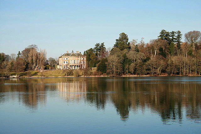
1020:== {{int:filedesc}} == {{Information |description={{en|1=Haining Loch A beautiful loch surrounded by woodland on the south side of Selkirk. The Haining, a plain 18th century classical house, sits in the background. The original house was built in 1794, wa
255:
43:
447:– You must give appropriate credit, provide a link to the license, and indicate if changes were made. You may do so in any reasonable manner, but not in any way that suggests the licensor endorses you or your use.
898:
798:
83:
51:
699:
663:
627:
329:
279:
1049:
734:
1217:
364:
1080:
This file contains additional information, probably added from the digital camera or scanner used to create or digitize it.
454:
884:
590:
939:
912:
868:
839:
812:
712:
683:
611:
583:
568:
555:
770:
742:
727:
647:
528:
511:
1186:
1034:
351:
1039:
410:
1002:
997:
42:
1083:
If the file has been modified from its original state, some details may not fully reflect the modified file.
1102:
1254:
453:– If you remix, transform, or build upon the material, you must distribute your contributions under the
371:
on the
Geograph website for the photographer's contact details. The copyright on this image is owned by
1013:
407:
1274:
905:"}},"text\/plain":{"en":{"P7787":"0 degree"}}}}": -->
805:"}},"text\/plain":{"en":{"P7787":"0 degree"}}}}": -->
91:
224:
183:
749:
719:
575:
208:
1092:
335:
285:
1334:
1264:
1236:
1109:
376:
78:
1149:
1284:
1044:
191:
136:
1129:
319:
269:
157:
147:
1119:
356:
172:
368:
970:
Click on a date/time to view the file as it appeared at that time.
321:
271:
296:
246:
167:
66:
306:
55° 32′ 27.8″ N, 2° 50′ 33″ W
256:
55° 32′ 21.3″ N, 2° 50′ 33″ W
495:
Add a one-line explanation of what this file represents
1067:
110:
90:
Commons is a freely licensed media file repository.
664:
Creative
Commons Attribution-ShareAlike 2.0 Generic
56:(640 × 427 pixels, file size: 132 KB, MIME type:
1279:Flash did not fire, compulsory flash suppression
464:https://creativecommons.org/licenses/by-sa/2.0
71:
470:Creative Commons Attribution-Share Alike 2.0
388:
8:
902:
802:
430:– to copy, distribute and transmit the work
116:Haining Loch - geograph.org.uk - 693968.jpg
52:Haining_Loch_-_geograph.org.uk_-_693968.jpg
1085:
972:
491:
1060:The following other wikis use this file:
750:https://www.geograph.org.uk/photo/693968
576:https://www.geograph.org.uk/profile/6638
1342:
1332:
1324:
1316:
1308:
1300:
1292:
1282:
1272:
1262:
1252:
1244:
1234:
1226:
1215:
1207:
1199:
1191:
1181:
1173:
1165:
1157:
1146:
1138:
1127:
1117:
1107:
1097:
1032:
926:
910:
882:
866:
826:
810:
784:
768:
697:
681:
661:
645:
625:
609:
542:
526:
509:
506:
487:
480:
299:
249:
328:View this and other nearby images on:
278:View this and other nearby images on:
1087:
1030:The following 4 pages use this file:
7:
375:and is licensed for reuse under the
961:
411:Attribution-Share Alike 2.0 Generic
399:
394:
379:Attribution-ShareAlike 2.0 license.
1078:
500:
494:
385:
362:
120:
103:
49:
499:
1140:Date and time of data generation
813:coordinates of the point of view
485:
441:Under the following conditions:
406:This file is licensed under the
398:
393:
387:
355:
334:
320:
312:
284:
270:
262:
190:
171:
70:
31:
21:
1050:User:Stinglehammer/Scottish WLM
482:
121:
46:No higher resolution available.
14:
700:file available on the internet
481:
363:This image was taken from the
26:
1:
913:coordinates of depicted place
36:
735:Geograph Britain and Ireland
584:object of statement has role
507:Items portrayed in this file
1310:Focal plane resolution unit
1228:Date and time of digitizing
928:55°32'27.82"N, 2°50'33.36"W
828:55°32'21.34"N, 2°50'33.36"W
1364:
1187:Adobe Photoshop CS Windows
1064:Usage on www.wikidata.org
1035:John Pringle, Lord Haining
455:same or compatible license
311:
261:
237:Walter Baxter /
218:Walter Baxter /
1193:File change date and time
962:
16:
1302:Focal plane Y resolution
1294:Focal plane X resolution
1040:John Pringle (died 1792)
713:geograph.org.uk image ID
484:
421:
77:This is a file from the
1318:Custom image processing
1231:13:16, 16 February 2008
1196:22:45, 16 February 2008
1143:13:16, 16 February 2008
1019:
209:required by the license
170:
163:
153:
142:
135:
132:
113:
81:. Information from its
1103:Canon EOS 400D DIGITAL
998:05:07, 8 February 2011
369:this photograph's page
340:55.541060; -2.842600
290:55.539260; -2.842600
84:description page there
1167:Horizontal resolution
1201:Y and C positioning
1175:Vertical resolution
1089:Camera manufacturer
436:– to adapt the work
1344:Scene capture type
1339:Auto white balance
556:author name string
1351:
1350:
1114:1/125 sec (0.008)
1056:Global file usage
1023:
904:
804:
648:copyright license
493:
384:
383:
367:collection. See
345:
344:
295:
294:
244:
243:
212:
199:
198:
178:This file has an
99:
98:
79:Wikimedia Commons
32:Global file usage
1355:
1305:4,453.6082474227
1297:4,433.2953249715
1209:Exposure Program
1086:
1010:
950:
949:
944:
850:
849:
844:
786:16 February 2008
752:
747:
743:described at URL
737:
732:
722:
717:
612:copyright status
593:
588:
578:
573:
563:
560:
477:
474:
471:
468:
465:
457:as the original.
419:
408:Creative Commons
402:
401:
397:
396:
391:
390:
377:Creative Commons
365:Geograph project
359:
352:
341:
338:
324:
323:
317:
316:
315:
309:
308:
297:
291:
288:
274:
273:
267:
266:
265:
259:
258:
247:
206:
194:
175:
168:
138:
137:16 February 2008
127:a woodland path.
125:
117:
111:
95:
74:
73:
67:
61:
59:
1363:
1362:
1358:
1357:
1356:
1354:
1353:
1352:
1241:6.9657897949219
1074:
1054:
1024:
1016:
1008:
964:
963:
960:
959:
958:
957:
956:
955:
954:
953:
952:
951:
947:
945:
942:
933:
932:
931:
929:
919:
918:
917:
915:
896:
895:
894:
893:
892:
891:
890:
889:
887:
875:
874:
873:
871:
860:
859:
858:
857:
856:
855:
854:
853:
852:
851:
847:
845:
842:
833:
832:
831:
829:
819:
818:
817:
815:
796:
795:
794:
793:
792:
791:
790:
789:
787:
777:
776:
775:
773:
762:
761:
760:
759:
758:
757:
756:
755:
754:
753:
748:
745:
739:
738:
733:
730:
724:
723:
718:
715:
706:
705:
704:
702:
690:
689:
688:
686:
675:
674:
673:
672:
671:
670:
669:
668:
666:
654:
653:
652:
650:
639:
638:
637:
636:
635:
634:
633:
632:
630:
618:
617:
616:
614:
603:
602:
601:
600:
599:
598:
597:
596:
595:
594:
589:
586:
580:
579:
574:
571:
565:
564:
561:
558:
549:
548:
547:
545:
535:
534:
533:
531:
520:
519:
518:
517:
516:
514:
498:
497:
496:
479:
478:
475:
472:
469:
466:
463:
462:
420:
417:
414:
403:
380:
350:
339:
313:
304:
303:
300:Object location
289:
263:
254:
253:
250:Camera location
245:
234:
227:
215:
195:
184:The Haining.jpg
180:extracted image
148:geograph.org.uk
128:
115:
108:
101:
100:
89:
88:
87:is shown below.
63:
57:
55:
48:
47:
12:
11:
5:
1361:
1359:
1349:
1348:
1345:
1341:
1340:
1337:
1331:
1330:
1327:
1323:
1322:
1321:Normal process
1319:
1315:
1314:
1311:
1307:
1306:
1303:
1299:
1298:
1295:
1291:
1290:
1287:
1281:
1280:
1277:
1271:
1270:
1267:
1261:
1260:
1257:
1251:
1250:
1247:
1243:
1242:
1239:
1233:
1232:
1229:
1225:
1224:
1221:
1214:
1213:
1212:Normal program
1210:
1206:
1205:
1202:
1198:
1197:
1194:
1190:
1189:
1184:
1180:
1179:
1176:
1172:
1171:
1168:
1164:
1163:
1160:
1156:
1155:
1152:
1145:
1144:
1141:
1137:
1136:
1133:
1126:
1125:
1122:
1116:
1115:
1112:
1106:
1105:
1100:
1096:
1095:
1090:
1077:
1073:
1072:
1071:
1070:
1058:
1057:
1053:
1052:
1047:
1042:
1037:
1028:
1027:
1022:
1021:
1018:
1014:
1011:
1005:
1000:
995:
991:
990:
987:
984:
981:
978:
975:
968:
967:
938:
937:
936:
935:
934:
930:
927:
925:
924:
923:
922:
921:
920:
916:
911:
909:
908:
907:
906:
900:
888:
885:Canon EOS 400D
883:
881:
880:
879:
878:
877:
876:
872:
867:
865:
864:
863:
862:
861:
838:
837:
836:
835:
834:
830:
827:
825:
824:
823:
822:
821:
820:
816:
811:
809:
808:
807:
806:
800:
788:
785:
783:
782:
781:
780:
779:
778:
774:
769:
767:
766:
765:
764:
763:
741:
740:
726:
725:
711:
710:
709:
708:
707:
703:
698:
696:
695:
694:
693:
692:
691:
687:
684:source of file
682:
680:
679:
678:
677:
676:
667:
662:
660:
659:
658:
657:
656:
655:
651:
646:
644:
643:
642:
641:
640:
631:
626:
624:
623:
622:
621:
620:
619:
615:
610:
608:
607:
606:
605:
604:
582:
581:
567:
566:
554:
553:
552:
551:
550:
546:
543:
541:
540:
539:
538:
537:
536:
532:
527:
525:
524:
523:
522:
521:
515:
510:
508:
505:
504:
503:
502:
501:
490:
489:
486:
483:
461:
460:
459:
458:
448:
439:
438:
437:
431:
424:You are free:
415:
405:
404:
386:
382:
381:
360:
349:
346:
343:
342:
332:
326:
301:
293:
292:
282:
276:
251:
242:
241:
235:
232:
229:
228:
223:
216:
213:
201:
200:
197:
196:
189:
187:
176:
165:
164:Other versions
161:
160:
155:
151:
150:
144:
140:
139:
134:
130:
129:
118:
109:
107:
104:
102:
97:
96:
75:
65:
64:
45:
41:
40:
39:
34:
29:
24:
19:
13:
10:
9:
6:
4:
3:
2:
1360:
1346:
1343:
1338:
1336:
1335:White balance
1333:
1329:Auto exposure
1328:
1326:Exposure mode
1325:
1320:
1317:
1312:
1309:
1304:
1301:
1296:
1293:
1288:
1286:
1283:
1278:
1276:
1273:
1268:
1266:
1265:Metering mode
1263:
1258:
1256:
1255:Exposure bias
1253:
1248:
1246:APEX aperture
1245:
1240:
1238:
1237:Shutter speed
1235:
1230:
1227:
1222:
1219:
1216:
1211:
1208:
1203:
1200:
1195:
1192:
1188:
1185:
1183:Software used
1182:
1177:
1174:
1169:
1166:
1161:
1158:
1153:
1151:
1147:
1142:
1139:
1134:
1131:
1128:
1123:
1121:
1118:
1113:
1111:
1110:Exposure time
1108:
1104:
1101:
1098:
1094:
1091:
1088:
1084:
1081:
1075:
1069:
1066:
1065:
1063:
1062:
1061:
1055:
1051:
1048:
1046:
1043:
1041:
1038:
1036:
1033:
1031:
1025:
1017:
1012:
1006:
1004:
1001:
999:
996:
993:
992:
988:
985:
982:
979:
976:
974:
973:
971:
965:
941:
914:
886:
870:
869:captured with
841:
814:
772:
751:
744:
736:
729:
721:
714:
701:
685:
665:
649:
629:
613:
592:
585:
577:
570:
562:Walter Baxter
557:
530:
513:
467:CC BY-SA 2.0
456:
452:
449:
446:
443:
442:
440:
435:
432:
429:
426:
425:
423:
422:
418:Walter Baxter
416:Attribution:
412:
409:
392:
378:
374:
373:Walter Baxter
370:
366:
361:
358:
354:
353:
347:
337:
333:
331:
330:OpenStreetMap
327:
325:
307:
302:
298:
287:
283:
281:
280:OpenStreetMap
277:
275:
257:
252:
248:
240:
236:
231:
230:
226:
222: /
221:
217:
210:
205:
203:
202:
193:
188:
185:
181:
177:
174:
169:
166:
162:
159:
158:Walter Baxter
156:
152:
149:
145:
141:
131:
124:
119:
112:
105:
93:
86:
85:
80:
76:
69:
68:
62:
53:
44:
38:
35:
33:
30:
28:
25:
23:
20:
18:
15:
1150:focal length
1099:Camera model
1082:
1079:
1059:
1029:
969:
966:File history
591:photographer
450:
444:
433:
427:
372:
310:
260:
239:Haining Loch
238:
225:CC BY-SA 2.0
220:Haining Loch
219:
179:
122:
92:You can help
82:
50:
22:File history
1285:Color space
1159:Orientation
1045:The Haining
1015:GeographBot
628:copyrighted
451:share alike
445:attribution
204:Attribution
114:Description
1026:File usage
1007:640 × 427
983:Dimensions
544:some value
58:image/jpeg
27:File usage
1130:ISO speed
980:Thumbnail
977:Date/Time
771:inception
348:Licensing
233:InfoField
214:InfoField
123:English:
1347:Standard
1204:Co-sited
1120:F-number
1076:Metadata
1068:Q7738629
1009:(132 KB)
728:operator
488:Captions
434:to remix
428:to share
413:license.
37:Metadata
1269:Pattern
1220:version
994:current
989:Comment
940:heading
899:heading
840:heading
799:heading
529:creator
512:depicts
492:English
106:Summary
54:
1313:inches
1178:72 dpi
1170:72 dpi
1162:Normal
1132:rating
948:degree
903:degree
848:degree
803:degree
720:693968
318:
268:
154:Author
143:Source
1275:Flash
1154:50 mm
1148:Lens
1093:Canon
146:From
1289:sRGB
1223:2.21
1218:Exif
986:User
476:true
473:true
133:Date
17:File
1135:100
1124:f/8
569:URL
946:0
943::
846:0
843::
746::
731::
716::
587::
572::
559::
182::
1259:1
1249:6
211:)
207:(
186:.
94:.
60:)
Text is available under the Creative Commons Attribution-ShareAlike License. Additional terms may apply.

_heading:0.00&language=en)
_heading:0.00&language=en)
