321:
177:
453:
405:
467:
327:
72:
900:
376:– You must give appropriate credit, provide a link to the license, and indicate if changes were made. You may do so in any reasonable manner, but not in any way that suggests the licensor endorses you or your use.
116:
43:
183:
444:
83:
51:
982:
164:
844:
577:
541:
460:
1040:
This file contains additional information, probably added from the digital camera or scanner used to create or digitize it.
810:
776:
739:
702:
665:
631:
525:
837:
597:
561:
508:
1043:
If the file has been modified from its original state, some details may not fully reflect the modified file.
416:
935:
The following pages on the
English Knowledge (XXG) use this file (pages on other projects are not listed):
124:
962:
337:
307:
899:
894:
334:
120:
42:
910:
992:
944:
922:
91:
412:
171:
145:
345:
191:
918:
420:
997:
466:
939:
925:
on July 7, 2017. |Source=[http://www.gsi.go.jp/BOUSAI/H29hukuoka_ooita-heavyrain.h...
78:
424:, who confirmed that it was available there under the stated license on that date.
450:
187:
135:
917:{{Information |Description=Akaya River was overflowed by Kyūshū Heavy Rain in
297:
288:
279:
270:
261:
252:
243:
234:
225:
216:
207:
198:
1017:
972:
867:
Click on a date/time to view the file as it appeared at that time.
624:
1007:
445:
33° 22′ 53.27″ N, 130° 50′ 28.18″ E
452:
435:
66:
492:
Add a one-line explanation of what this file represents
298:
289:
1027:
188:
Creative
Commons Attribution License 4.0 International
399:
105:
90:
Commons is a freely licensed media file repository.
184:
Government of Japan
Standard Terms of Use (Ver.2.0)
280:
271:
262:
253:
244:
235:
226:
217:
208:
199:
56:(461 × 258 pixels, file size: 299 KB, MIME type:
578:Creative Commons Attribution 4.0 International
71:
320:
8:
383:https://creativecommons.org/licenses/by/4.0
359:– to copy, distribute and transmit the work
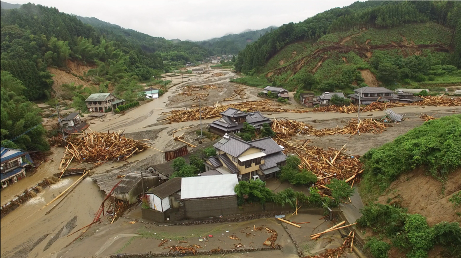
186:. The Terms of Use are compatible with the
176:
1045:
869:
488:
411:This file, which was originally posted to
306:
955:The following other wikis use this file:
190:. For the terms of use of this work, see
826:28ebf2f4804674ccca030c7f56272bbe29b63246
413:平成29年6月30日からの梅雨前線に伴う大雨及び台風3号に関する情報|国土地理院
146:平成29年6月30日からの梅雨前線に伴う大雨及び台風3号に関する情報|国土地理院
1055:
1047:
937:
824:
808:
790:
774:
753:
737:
716:
700:
679:
663:
645:
629:
611:
595:
575:
559:
539:
523:
506:
503:
484:
477:
438:
459:View this and other nearby images on:
7:
115:Akatani River was overflowed by the
858:
326:
111:Hakimasue Asakura City 20170707.png
52:Hakimasue_Asakura_City_20170707.png
1038:
497:
491:
415:, was reviewed on 16 July 2017 by
410:
350:
317:
103:
49:
496:
389:Creative Commons Attribution 4.0
632:coordinates of the point of view
482:
465:
451:
403:
370:Under the following conditions:
333:This file is licensed under the
325:
319:
182:This work is licensed under the
175:
70:
31:
21:
647:33°22'53.274"N, 130°50'28.176"E
479:
46:No higher resolution available.
14:
478:
26:
1:
338:Attribution 4.0 International
36:
504:Items portrayed in this file
1004:Usage on nds.wikipedia.org
1077:
1024:Usage on www.wikidata.org
1014:Usage on nl.wikipedia.org
979:Usage on ja.wikipedia.org
969:Usage on de.wikipedia.org
959:Usage on ar.wikipedia.org
117:Northern Kyūshū Heavy Rain
989:Usage on ja.wikinews.org
859:
16:
481:
77:This is a file from the
1018:Gebruiker:Aeroid/Floods
916:
159:
151:
141:
134:
131:
108:
81:. Information from its
973:Benutzer:Aeroid/Floods
471:33.381465; 130.841160
84:description page there
1049:Horizontal resolution
1008:Bruker:Aeroid/Floods
838:determination method
1057:Vertical resolution
895:14:21, 10 July 2017
365:– to adapt the work
945:User:Aeroid/Floods
923:Fukuoka Prefecture
125:Fukuoka Prefecture
1064:
1063:
951:Global file usage
928:
562:copyright license
490:
476:
475:
433:
432:
429:
428:
316:
315:
310:
192:this license page
168:
165:Reusing this file
99:
98:
79:Wikimedia Commons
32:Global file usage
1068:
1046:
907:
847:
842:
758:
721:
684:
526:copyright status
472:
469:
455:
454:
448:
447:
436:
407:
406:
400:
396:
393:
390:
387:
384:
348:
335:Creative Commons
329:
328:
323:
322:
311:
179:
178:
172:
162:
137:
127:on July 7, 2017.
112:
106:
95:
74:
73:
67:
61:
59:
1076:
1075:
1071:
1070:
1069:
1067:
1066:
1065:
1034:
963:2017 في اليابان
949:
936:
929:
913:
905:
861:
860:
857:
856:
855:
854:
853:
852:
851:
850:
849:
848:
843:
840:
831:
830:
829:
827:
817:
816:
815:
813:
802:
801:
800:
799:
798:
797:
796:
795:
793:
783:
782:
781:
779:
768:
767:
766:
765:
764:
763:
762:
761:
759:
756:
746:
745:
744:
742:
731:
730:
729:
728:
727:
726:
725:
724:
722:
719:
709:
708:
707:
705:
694:
693:
692:
691:
690:
689:
688:
687:
685:
682:
672:
671:
670:
668:
657:
656:
655:
654:
653:
652:
651:
650:
648:
638:
637:
636:
634:
623:
622:
621:
620:
619:
618:
617:
616:
614:
604:
603:
602:
600:
589:
588:
587:
586:
585:
584:
583:
582:
580:
568:
567:
566:
564:
553:
552:
551:
550:
549:
548:
547:
546:
544:
532:
531:
530:
528:
517:
516:
515:
514:
513:
511:
495:
494:
493:
470:
443:
442:
439:Camera location
434:
425:
404:
398:
397:
394:
391:
388:
385:
382:
381:
349:
344:
341:
330:
300:
291:
282:
273:
264:
255:
246:
237:
228:
219:
210:
201:
197:
110:
101:
100:
89:
88:
87:is shown below.
63:
57:
55:
48:
47:
12:
11:
5:
1074:
1072:
1062:
1061:
1058:
1054:
1053:
1050:
1037:
1033:
1032:
1031:
1030:
1022:
1021:
1020:
1012:
1011:
1010:
1002:
1001:
1000:
995:
993:短信:2017年/7月/5日
987:
986:
985:
977:
976:
975:
967:
966:
965:
953:
952:
948:
947:
942:
934:
933:
932:
927:
926:
915:
911:
908:
902:
897:
892:
888:
887:
884:
881:
878:
875:
872:
865:
864:
836:
835:
834:
833:
832:
828:
825:
823:
822:
821:
820:
819:
818:
814:
809:
807:
806:
805:
804:
803:
794:
791:
789:
788:
787:
786:
785:
784:
780:
775:
773:
772:
771:
770:
769:
760:
754:
752:
751:
750:
749:
748:
747:
743:
738:
736:
735:
734:
733:
732:
723:
717:
715:
714:
713:
712:
711:
710:
706:
701:
699:
698:
697:
696:
695:
686:
680:
678:
677:
676:
675:
674:
673:
669:
664:
662:
661:
660:
659:
658:
649:
646:
644:
643:
642:
641:
640:
639:
635:
630:
628:
627:
626:
625:
615:
612:
610:
609:
608:
607:
606:
605:
601:
596:
594:
593:
592:
591:
590:
581:
576:
574:
573:
572:
571:
570:
569:
565:
560:
558:
557:
556:
555:
554:
545:
540:
538:
537:
536:
535:
534:
533:
529:
524:
522:
521:
520:
519:
518:
512:
507:
505:
502:
501:
500:
499:
498:
487:
486:
483:
480:
474:
473:
463:
457:
440:
431:
430:
427:
426:
421:Daphne Lantier
408:
380:
379:
378:
377:
368:
367:
366:
360:
353:You are free:
342:
332:
331:
318:
314:
313:
180:
169:
157:
156:
153:
149:
148:
143:
139:
138:
133:
129:
128:
113:
104:
102:
97:
96:
75:
65:
64:
45:
41:
40:
39:
34:
29:
24:
19:
13:
10:
9:
6:
4:
3:
2:
1073:
1059:
1056:
1051:
1048:
1044:
1041:
1035:
1029:
1026:
1025:
1023:
1019:
1016:
1015:
1013:
1009:
1006:
1005:
1003:
999:
996:
994:
991:
990:
988:
984:
983:平成29年7月九州北部豪雨
981:
980:
978:
974:
971:
970:
968:
964:
961:
960:
958:
957:
956:
950:
946:
943:
941:
940:2017 in Japan
938:
930:
924:
920:
919:Asakura, City
914:
909:
903:
901:
898:
896:
893:
890:
889:
885:
882:
879:
876:
873:
871:
870:
868:
862:
846:
839:
812:
778:
741:
704:
667:
633:
599:
579:
563:
543:
527:
510:
468:
464:
462:
461:OpenStreetMap
458:
456:
446:
441:
437:
423:
422:
418:
414:
409:
402:
401:
375:
372:
371:
369:
364:
361:
358:
355:
354:
352:
351:
347:
343:Attribution:
339:
336:
324:
312:
309:
305:
301:
296:
292:
287:
283:
278:
274:
269:
265:
260:
256:
251:
247:
242:
238:
233:
229:
224:
220:
215:
211:
206:
202:
195:
193:
189:
185:
181:
174:
173:
170:
166:
161:
158:
155:国土地理院企画部防災推進室
154:
150:
147:
144:
140:
130:
126:
122:
118:
114:
107:
93:
86:
85:
80:
76:
69:
68:
62:
53:
44:
38:
35:
33:
30:
28:
25:
23:
20:
18:
15:
1042:
1039:
954:
866:
863:File history
419:
373:
362:
356:
303:
294:
285:
276:
267:
258:
249:
240:
231:
222:
213:
204:
196:
121:Asakura City
92:You can help
82:
50:
22:File history
998:短信:2017年/7月
613:7 July 2017
542:copyrighted
374:attribution
346:国土地理院ウェブサイト
263:slovenščina
136:7 July 2017
109:Description
931:File usage
904:461 × 258
880:Dimensions
777:media type
386:CC BY 4.0
281:Tiếng Việt
236:македонски
160:Permission
27:File usage
1060:37.78 dpc
1052:37.78 dpc
1028:Q38276364
877:Thumbnail
874:Date/Time
792:image/png
666:data size
598:inception
254:português
58:image/png
1036:Metadata
912:Scanyaro
906:(299 KB)
811:checksum
681:306,292
485:Captions
417:reviewer
363:to remix
357:to share
340:license.
37:Metadata
891:current
886:Comment
509:depicts
489:English
272:svenska
245:русский
209:español
200:English
54:
703:height
449:
302:
293:
284:
275:
266:
257:
248:
239:
230:
221:
212:
203:
152:Author
142:Source
845:SHA-1
757:pixel
740:width
720:pixel
299:繁體中文
290:简体中文
883:User
755:461
718:258
683:byte
395:true
392:true
132:Date
17:File
308:+/−
227:한국어
218:日本語
119:in
921:,
841::
194:.
123:,
304:∙
295:∙
286:∙
277:∙
268:∙
259:∙
250:∙
241:∙
232:∙
223:∙
214:∙
205:∙
167:)
163:(
94:.
60:)
Text is available under the Creative Commons Attribution-ShareAlike License. Additional terms may apply.