916:
1042:
972:
1028:
860:
958:
902:
1056:
986:
1070:
944:
1000:
930:
1014:
639:
874:
888:
765:
695:
751:
583:
681:
625:
779:
709:
793:
362:
667:
723:
653:
488:
418:
737:
597:
474:
306:
611:
404:
348:
502:
432:
516:
390:
38:
446:
376:
460:
231:
320:
334:
1405:
1099:
1411:
1147:
1416:
94:
1858:
1828:
1798:
1768:
825:
548:
271:
245:
aims to show the major low mountain ranges of
Germany in a uniform design. All maps are created on the same scale, and the background reliefs base upon the same color scheme. The reliefs are also available as separate files.
818:
541:
264:
242:
1463:– You must give appropriate credit, provide a link to the license, and indicate if changes were made. You may do so in any reasonable manner, but not in any way that suggests the licensor endorses you or your use.
1118:
The ODbL does not require any particular license for maps produced from ODbL data. Prior to 1 August 2020, map tiles produced by the OpenStreetMap
Foundation were licensed under the
60:
56:
52:
48:
42:
915:
105:
73:
1041:
832:
555:
278:
1027:
971:
957:
859:
1055:
638:
985:
943:
901:
1161:
1069:
764:
999:
929:
250:
361:
750:
694:
680:
582:
1857:
1852:
1827:
1822:
1797:
1792:
1013:
778:
873:
487:
201:
887:
708:
666:
473:
417:
1970:
403:
305:
624:
501:
1679:
1643:
792:
722:
652:
1470:
431:
389:
1627:
1599:
1584:
1571:
736:
347:
515:
1699:
1663:
1544:
1527:
596:
610:
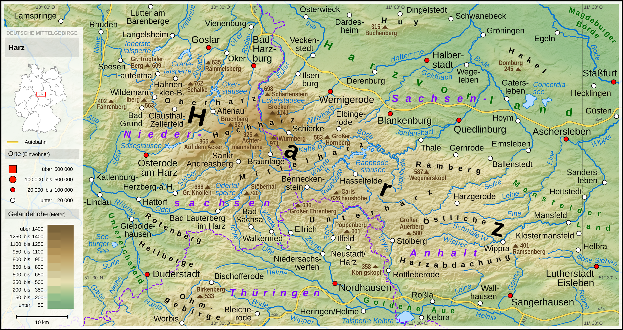
445:
375:
1767:
1762:
1154:
64:
37:
459:
1426:
1606:
1386:
319:
921:
644:
367:
333:
1893:
The following pages on the
English Knowledge (XXG) use this file (pages on other projects are not listed):
1469:– If you remix, transform, or build upon the material, you must distribute your contributions under the
1061:
784:
507:
1815:+Schierke, +Wippra, +Wallhausen, +Dardesheim, +Wegeleben, +Güsten, +Rammelsberg; and some other details
1423:
2040:
1995:
1960:
1880:
1047:
963:
949:
770:
686:
672:
493:
409:
395:
160:
113:
230:
1033:
756:
479:
1093:
865:
588:
311:
1591:
1985:
1975:
810:
1146:
1980:
205:
991:
977:
714:
700:
437:
423:
1965:
1955:
100:
1196:
907:
630:
353:
1119:
1111:
1075:
798:
521:
190:
1868:
1838:
1808:
1778:
171:
1304:
1268:
1376:
1367:
1358:
1349:
1340:
1331:
1322:
1313:
1295:
1286:
1277:
1259:
1250:
1241:
1232:
1223:
1214:
1205:
1187:
1178:
1169:
1005:
935:
728:
658:
451:
381:
217:
1845:-Schulenberg +Hahnenklee Wiegersdorf->Ilfeld +Neustadt/Harz +Poppenberg
1019:
742:
465:
1098:
1971:
Benutzer:D.W.Germann/Liste von Gipshöhlen im Südharzer
Zechsteingürtel
533:
879:
602:
325:
1735:
Click on a date/time to view the file as it appeared at that time.
893:
616:
339:
256:
149:
2050:
1925:
1122:. Maps produced by other people may be subject to other licences.
1107:
1897:
1876:
195:
814:
537:
260:
2000:
186:
88:
1950:
1940:
2090:
1945:
1875:{{Information |Description ={{en|1=Topographic map of
1197:
237:
Topographic maps of German low mountain ranges (A series)
1990:
1930:
1883:}} |Source ={{Own using}} * with [http://dds...
1511:
Add a one-line explanation of what this file represents
848:
This series is under development and not yet completed.
571:
This series is under development and not yet completed.
294:
This series is under development and not yet completed.
78:(2,450 × 1,300 pixels, file size: 4.46 MB, MIME type:
1996:
1961:
Benutzer:D.W.Germann/Liste der
Dennert-Tannen im Harz
253:
in the German language
Knowledge (XXG) (German only).
1680:
Creative
Commons Attribution-ShareAlike 3.0 Unported
1141:
132:
112:
Commons is a freely licensed media file repository.
1915:
1305:
1269:
1935:
1377:
1368:
1359:
1350:
1341:
1332:
1323:
1314:
1296:
1287:
1278:
1260:
1251:
1242:
1233:
1224:
1215:
1206:
1188:
1179:
1170:
1153:This map has been made or improved in the German
2080:
2070:
2060:
2030:
2020:
2010:
1986:Glossar zur geologischen Gliederung des Harzes
1956:Knowledge (XXG):Kartenwerkstatt/Archiv/2017-10
1480:https://creativecommons.org/licenses/by-sa/3.0
93:
1486:Creative Commons Attribution-Share Alike 3.0
1404:
1131:http://opendatacommons.org/licenses/odbl/1.0/
826:
549:
272:
138:Harz - Deutsche Mittelgebirge, Serie A-de.png
8:
1981:Benutzer:D.W.Germann/Eigenes/Mediensammlung
1446:– to copy, distribute and transmit the work
1737:
1507:
1385:
833:
819:
811:
556:
542:
534:
279:
265:
257:
1908:The following other wikis use this file:
1592:https://commons.wikimedia.org/user:Thoroe
202:File:Karte_Bundesrepublik_Deutschland.svg
1976:Benutzer:Thoroe/Making of Thüringer Wald
1966:Benutzer:D.W.Germann/Sachsenstein (Harz)
1895:
1713:
1697:
1677:
1661:
1641:
1625:
1558:
1542:
1525:
1522:
1503:
1496:
855:
841:Topographic reliefs (with water bodies)
578:
301:
7:
1427:Attribution-Share Alike 3.0 Unported
1110:, which is made available under the
1106:This work contains information from
1726:
1415:
1410:
1879:}} {{de|1=Topografische Karte des
1516:
1510:
1401:
1152:
153:
142:
125:
71:
1515:
1501:
1457:Under the following conditions:
1422:This file is licensed under the
1414:
1409:
1403:
1145:
1097:
1068:
1054:
1040:
1026:
1012:
998:
984:
970:
956:
942:
928:
914:
900:
886:
872:
858:
791:
777:
763:
749:
735:
721:
707:
693:
679:
665:
651:
637:
623:
609:
595:
581:
514:
500:
486:
472:
458:
444:
430:
416:
402:
388:
374:
360:
346:
332:
318:
304:
229:
92:
31:
21:
1498:
143:
14:
1497:
154:
26:
1:
2041:利用者:Krorokeroro/sandbox/shiga
251:the making-of one of the maps
1523:Items portrayed in this file
1112:Open Database License (ODbL)
1096:
2047:Usage on nds.wikipedia.org
187:Generic Mapping Tools (GMT)
2109:
2087:Usage on tr.wikipedia.org
2077:Usage on sv.wikipedia.org
2067:Usage on sl.wikipedia.org
2057:Usage on no.wikipedia.org
2037:Usage on ja.wikipedia.org
2027:Usage on hu.wikipedia.org
2017:Usage on et.wikipedia.org
2007:Usage on es.wikipedia.org
1922:Usage on de.wikipedia.org
1912:Usage on da.wikipedia.org
1785:Autobahn 36 / Autobahn 369
1471:same or compatible license
1727:
853:
846:
576:
569:
299:
292:
16:
1500:
1437:
159:Topografische Karte des
99:This is a file from the
1874:
1844:
1814:
1784:
223:
213:
177:
170:
167:
135:
103:. Information from its
1853:16:03, 15 October 2017
1823:13:21, 16 October 2017
1793:10:41, 19 October 2017
1763:23:44, 31 January 2019
106:description page there
41:Size of this preview:
1125:Open Database License
922:Upper Palatine Forest
645:Upper Palatine Forest
368:Upper Palatine Forest
1926:Harz (Mittelgebirge)
1164:to improve as well.
1120:CC-BY-SA-2.0 license
1062:Vogelsberg Mountains
785:Vogelsberg Mountains
508:Vogelsberg Mountains
65:2,450 × 1,300 pixels
2051:Harz (Middelbargen)
1452:– to adapt the work
564:Topographic reliefs
148:Topographic map of
47:Other resolutions:
1600:Wikimedia username
1572:author name string
1198:Deutsch (Sie-Form)
61:1,280 × 679 pixels
57:1,024 × 543 pixels
2001:Eishockey im Harz
1904:Global file usage
1886:
1664:copyright license
1509:
1395:
1394:
1389:
1140:
1139:
1123:
1091:
1090:
1085:
1084:
1048:Thuringian Forest
964:Rothaar Mountains
808:
807:
771:Thuringian Forest
687:Rothaar Mountains
531:
530:
494:Thuringian Forest
410:Rothaar Mountains
121:
120:
101:Wikimedia Commons
32:Global file usage
2100:
1951:Buchenberg (Huy)
1865:
1835:
1805:
1775:
1628:copyright status
1609:
1604:
1594:
1589:
1579:
1576:
1493:
1490:
1487:
1484:
1481:
1473:as the original.
1435:
1424:Creative Commons
1418:
1417:
1413:
1412:
1407:
1406:
1390:
1149:
1142:
1135:
1132:
1129:
1126:
1117:
1101:
1094:
1072:
1058:
1044:
1034:Teutoburg Forest
1030:
1016:
1002:
988:
974:
960:
946:
932:
918:
904:
890:
876:
862:
835:
828:
821:
812:
795:
781:
767:
757:Teutoburg Forest
753:
739:
725:
711:
697:
683:
669:
655:
641:
627:
613:
599:
585:
558:
551:
544:
535:
518:
504:
490:
480:Teutoburg Forest
476:
462:
448:
434:
420:
406:
392:
378:
364:
350:
336:
322:
308:
287:Topographic maps
281:
274:
267:
258:
233:
182:Own work using:
173:
158:
147:
139:
133:
117:
96:
95:
89:
83:
81:
68:
53:640 × 340 pixels
49:320 × 170 pixels
43:800 × 424 pixels
2108:
2107:
2103:
2102:
2101:
2099:
2098:
2097:
1941:Benutzer:Thoroe
1902:
1894:
1887:
1871:
1863:
1841:
1833:
1811:
1803:
1781:
1773:
1729:
1728:
1725:
1724:
1723:
1722:
1721:
1720:
1719:
1718:
1716:
1715:15 October 2017
1706:
1705:
1704:
1702:
1691:
1690:
1689:
1688:
1687:
1686:
1685:
1684:
1682:
1670:
1669:
1668:
1666:
1655:
1654:
1653:
1652:
1651:
1650:
1649:
1648:
1646:
1634:
1633:
1632:
1630:
1619:
1618:
1617:
1616:
1615:
1614:
1613:
1612:
1611:
1610:
1605:
1602:
1596:
1595:
1590:
1587:
1581:
1580:
1577:
1574:
1565:
1564:
1563:
1561:
1551:
1550:
1549:
1547:
1536:
1535:
1534:
1533:
1532:
1530:
1514:
1513:
1512:
1495:
1494:
1491:
1488:
1485:
1482:
1479:
1478:
1436:
1433:
1430:
1419:
1400:
1391:
1379:
1370:
1361:
1352:
1343:
1334:
1325:
1316:
1307:
1298:
1289:
1280:
1271:
1262:
1253:
1244:
1235:
1226:
1217:
1208:
1199:
1190:
1181:
1172:
1168:
1165:
1155:Kartenwerkstatt
1133:
1130:
1127:
1124:
1092:
1087:
1086:
1081:
1078:
1073:
1064:
1059:
1050:
1045:
1036:
1031:
1022:
1017:
1008:
1003:
994:
989:
980:
975:
966:
961:
952:
947:
938:
933:
924:
919:
910:
905:
896:
891:
882:
877:
868:
866:Bavarian Forest
863:
849:
842:
839:
809:
804:
801:
796:
787:
782:
773:
768:
759:
754:
745:
740:
731:
726:
717:
712:
703:
698:
689:
684:
675:
670:
661:
656:
647:
642:
633:
628:
619:
614:
605:
600:
591:
589:Bavarian Forest
586:
572:
565:
562:
532:
527:
524:
519:
510:
505:
496:
491:
482:
477:
468:
463:
454:
449:
440:
435:
426:
421:
412:
407:
398:
393:
384:
379:
370:
365:
356:
351:
342:
337:
328:
323:
314:
312:Bavarian Forest
309:
295:
288:
285:
239:
234:
191:SRTM3 V2.1 data
172:15 October 2017
163:
152:
137:
130:
123:
122:
111:
110:
109:is shown below.
85:
79:
77:
70:
69:
46:
12:
11:
5:
2106:
2104:
2096:
2095:
2094:
2093:
2085:
2084:
2083:
2075:
2074:
2073:
2065:
2064:
2063:
2055:
2054:
2053:
2045:
2044:
2043:
2035:
2034:
2033:
2025:
2024:
2023:
2015:
2014:
2013:
2005:
2004:
2003:
1998:
1993:
1988:
1983:
1978:
1973:
1968:
1963:
1958:
1953:
1948:
1943:
1938:
1933:
1928:
1920:
1919:
1918:
1906:
1905:
1901:
1900:
1892:
1891:
1890:
1885:
1884:
1873:
1869:
1866:
1862:2,450 × 1,300
1860:
1855:
1850:
1847:
1846:
1843:
1839:
1836:
1832:2,450 × 1,300
1830:
1825:
1820:
1817:
1816:
1813:
1809:
1806:
1802:2,450 × 1,300
1800:
1795:
1790:
1787:
1786:
1783:
1779:
1776:
1772:2,450 × 1,300
1770:
1765:
1760:
1756:
1755:
1752:
1749:
1746:
1743:
1740:
1733:
1732:
1717:
1714:
1712:
1711:
1710:
1709:
1708:
1707:
1703:
1698:
1696:
1695:
1694:
1693:
1692:
1683:
1678:
1676:
1675:
1674:
1673:
1672:
1671:
1667:
1662:
1660:
1659:
1658:
1657:
1656:
1647:
1642:
1640:
1639:
1638:
1637:
1636:
1635:
1631:
1626:
1624:
1623:
1622:
1621:
1620:
1598:
1597:
1583:
1582:
1570:
1569:
1568:
1567:
1566:
1562:
1559:
1557:
1556:
1555:
1554:
1553:
1552:
1548:
1543:
1541:
1540:
1539:
1538:
1537:
1531:
1526:
1524:
1521:
1520:
1519:
1518:
1517:
1506:
1505:
1502:
1499:
1477:
1476:
1475:
1474:
1464:
1455:
1454:
1453:
1447:
1440:You are free:
1431:
1421:
1420:
1402:
1399:
1396:
1393:
1392:
1167:
1150:
1138:
1137:
1104:
1102:
1089:
1088:
1083:
1082:
1080:
1079:
1074:
1067:
1065:
1060:
1053:
1051:
1046:
1039:
1037:
1032:
1025:
1023:
1018:
1011:
1009:
1004:
997:
995:
990:
983:
981:
976:
969:
967:
962:
955:
953:
950:Rhön Mountains
948:
941:
939:
934:
927:
925:
920:
913:
911:
906:
899:
897:
892:
885:
883:
878:
871:
869:
864:
857:
854:
851:
850:
847:
844:
843:
840:
838:
837:
830:
823:
815:
806:
805:
803:
802:
797:
790:
788:
783:
776:
774:
769:
762:
760:
755:
748:
746:
741:
734:
732:
727:
720:
718:
713:
706:
704:
699:
692:
690:
685:
678:
676:
673:Rhön Mountains
671:
664:
662:
657:
650:
648:
643:
636:
634:
629:
622:
620:
615:
608:
606:
601:
594:
592:
587:
580:
577:
574:
573:
570:
567:
566:
563:
561:
560:
553:
546:
538:
529:
528:
526:
525:
520:
513:
511:
506:
499:
497:
492:
485:
483:
478:
471:
469:
464:
457:
455:
450:
443:
441:
436:
429:
427:
422:
415:
413:
408:
401:
399:
396:Rhön Mountains
394:
387:
385:
380:
373:
371:
366:
359:
357:
352:
345:
343:
338:
331:
329:
324:
317:
315:
310:
303:
300:
297:
296:
293:
290:
289:
286:
284:
283:
276:
269:
261:
235:
228:
227:
225:
224:Other versions
221:
220:
215:
211:
210:
209:
208:
199:
193:
179:
175:
174:
169:
165:
164:
140:
131:
129:
126:
124:
119:
118:
97:
87:
86:
40:
36:
35:
34:
29:
24:
19:
13:
10:
9:
6:
4:
3:
2:
2105:
2092:
2091:Kategori:Harz
2089:
2088:
2086:
2082:
2079:
2078:
2076:
2072:
2069:
2068:
2066:
2062:
2059:
2058:
2056:
2052:
2049:
2048:
2046:
2042:
2039:
2038:
2036:
2032:
2029:
2028:
2026:
2022:
2019:
2018:
2016:
2012:
2009:
2008:
2006:
2002:
1999:
1997:
1994:
1992:
1989:
1987:
1984:
1982:
1979:
1977:
1974:
1972:
1969:
1967:
1964:
1962:
1959:
1957:
1954:
1952:
1949:
1947:
1946:Benutzer:Frze
1944:
1942:
1939:
1937:
1934:
1932:
1929:
1927:
1924:
1923:
1921:
1917:
1914:
1913:
1911:
1910:
1909:
1903:
1899:
1896:
1888:
1882:
1878:
1872:
1867:
1861:
1859:
1856:
1854:
1851:
1849:
1848:
1842:
1837:
1831:
1829:
1826:
1824:
1821:
1819:
1818:
1812:
1807:
1801:
1799:
1796:
1794:
1791:
1789:
1788:
1782:
1777:
1771:
1769:
1766:
1764:
1761:
1758:
1757:
1753:
1750:
1747:
1744:
1741:
1739:
1738:
1736:
1730:
1701:
1681:
1665:
1645:
1629:
1608:
1601:
1593:
1586:
1573:
1546:
1529:
1483:CC BY-SA 3.0
1472:
1468:
1465:
1462:
1459:
1458:
1456:
1451:
1448:
1445:
1442:
1441:
1439:
1438:
1432:Attribution:
1428:
1425:
1408:
1397:
1388:
1384:
1380:
1375:
1371:
1366:
1362:
1357:
1353:
1348:
1344:
1339:
1335:
1330:
1326:
1321:
1317:
1312:
1308:
1303:
1299:
1294:
1290:
1285:
1281:
1276:
1272:
1267:
1263:
1258:
1254:
1249:
1245:
1240:
1236:
1231:
1227:
1222:
1218:
1213:
1209:
1204:
1200:
1195:
1191:
1186:
1182:
1177:
1173:
1166:
1163:
1159:
1156:
1151:
1148:
1144:
1143:
1136:
1121:
1115:
1113:
1109:
1108:OpenStreetMap
1105:
1103:
1100:
1095:
1077:
1071:
1066:
1063:
1057:
1052:
1049:
1043:
1038:
1035:
1029:
1024:
1021:
1015:
1010:
1007:
1001:
996:
993:
987:
982:
979:
973:
968:
965:
959:
954:
951:
945:
940:
937:
931:
926:
923:
917:
912:
909:
903:
898:
895:
889:
884:
881:
875:
870:
867:
861:
856:
852:
845:
836:
831:
829:
824:
822:
817:
816:
813:
800:
794:
789:
786:
780:
775:
772:
766:
761:
758:
752:
747:
744:
738:
733:
730:
724:
719:
716:
710:
705:
702:
696:
691:
688:
682:
677:
674:
668:
663:
660:
654:
649:
646:
640:
635:
632:
626:
621:
618:
612:
607:
604:
598:
593:
590:
584:
579:
575:
568:
559:
554:
552:
547:
545:
540:
539:
536:
523:
517:
512:
509:
503:
498:
495:
489:
484:
481:
475:
470:
467:
461:
456:
453:
447:
442:
439:
433:
428:
425:
419:
414:
411:
405:
400:
397:
391:
386:
383:
377:
372:
369:
363:
358:
355:
349:
344:
341:
335:
330:
327:
321:
316:
313:
307:
302:
298:
291:
282:
277:
275:
270:
268:
263:
262:
259:
255:
254:
252:
249:You can find
247:
244:
238:
232:
226:
222:
219:
216:
212:
207:
203:
200:
197:
196:OpenStreetMap
194:
192:
188:
185:
184:
183:
180:
176:
166:
162:
157:
151:
146:
141:
134:
127:
115:
108:
107:
102:
98:
91:
90:
84:
75:
74:Original file
66:
62:
58:
54:
50:
44:
39:
33:
30:
28:
25:
23:
20:
18:
15:
1907:
1734:
1731:File history
1466:
1460:
1449:
1443:
1434:Thomas Römer
1382:
1373:
1364:
1355:
1346:
1337:
1328:
1319:
1310:
1301:
1292:
1283:
1274:
1270:Plattdüütsch
1265:
1256:
1247:
1238:
1229:
1220:
1211:
1202:
1193:
1184:
1175:
1171:azərbaycanca
1162:propose maps
1157:
1116:
992:Black Forest
978:Swabian Jura
715:Black Forest
701:Swabian Jura
438:Black Forest
424:Swabian Jura
248:
240:
236:
206:David Liuzzo
181:
155:
144:
114:You can help
104:
72:
22:File history
1991:Siebermulde
1931:Harzvorland
1644:copyrighted
1467:share alike
1461:attribution
1315:slovenščina
136:Description
1889:File usage
1748:Dimensions
1560:some value
1333:македонски
1261:Nederlands
1160:. You can
1076:Westerwald
799:Westerwald
522:Westerwald
243:map series
27:File usage
1864:(4.59 MB)
1834:(4.59 MB)
1804:(4.59 MB)
1774:(4.46 MB)
1745:Thumbnail
1742:Date/Time
1700:inception
1398:Licensing
1306:sicilianu
1288:português
1158:(Map Lab)
156:Deutsch:
145:English:
80:image/png
1504:Captions
1450:to remix
1444:to share
1429:license.
1243:latviešu
1234:italiano
1225:français
1006:Spessart
936:Odenwald
908:Hunsrück
729:Spessart
659:Odenwald
631:Hunsrück
452:Spessart
382:Odenwald
354:Hunsrück
1759:current
1754:Comment
1545:creator
1528:depicts
1508:English
1360:հայերեն
1351:ქართული
1342:русский
1216:español
1207:English
1189:Deutsch
1180:čeština
128:Summary
76:
1916:Harzen
1881:Harzes
1870:Thoroe
1840:Thoroe
1810:Thoroe
1780:Thoroe
1607:Thoroe
1578:Thoroe
1381:
1372:
1363:
1354:
1345:
1336:
1327:
1318:
1309:
1300:
1297:română
1291:
1282:
1279:polski
1273:
1264:
1255:
1252:magyar
1246:
1237:
1228:
1219:
1210:
1201:
1192:
1183:
1174:
1020:Taunus
743:Taunus
466:Taunus
218:Thoroe
214:Author
178:Source
161:Harzes
1936:Hakel
1369:বাংলা
1324:suomi
880:Eifel
603:Eifel
326:Eifel
241:This
189:with
2081:Harz
2071:Harz
2061:Harz
2031:Harz
2021:Harz
2011:Harz
1898:Harz
1877:Harz
1751:User
1492:true
1489:true
1134:true
1128:ODbL
894:Harz
617:Harz
340:Harz
198:data
168:Date
150:Harz
17:File
1585:URL
1387:+/−
1378:ไทย
204:by
1603::
1588::
1575::
1114:.
63:|
59:|
55:|
51:|
45:.
1383:∙
1374:∙
1365:∙
1356:∙
1347:∙
1338:∙
1329:∙
1320:∙
1311:∙
1302:∙
1293:∙
1284:∙
1275:∙
1266:∙
1257:∙
1248:∙
1239:∙
1230:∙
1221:∙
1212:∙
1203:∙
1194:∙
1185:∙
1176:∙
834:e
827:t
820:v
557:e
550:t
543:v
280:e
273:t
266:v
116:.
82:)
67:.
Text is available under the Creative Commons Attribution-ShareAlike License. Additional terms may apply.

