163:
304:
244:
258:
310:
315:
95:
43:
856:
906:
235:
356:– You must give appropriate credit, provide a link to the license, and indicate if changes were made. You may do so in any reasonable manner, but not in any way that suggests the licensor endorses you or your use.
901:
877:
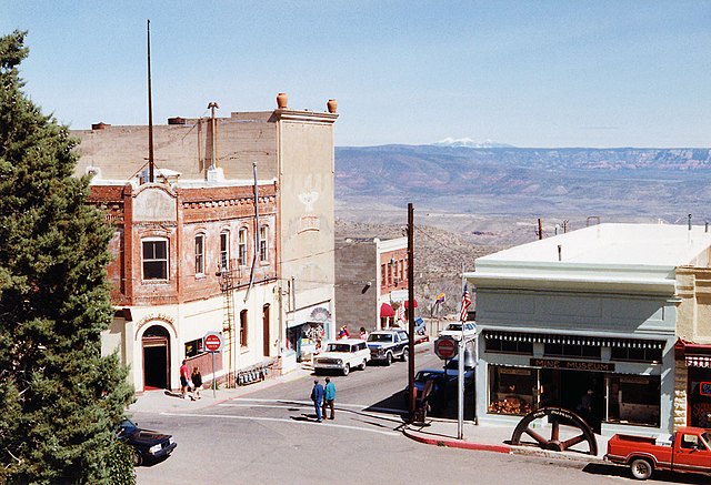
in common with other abandonded mining towns in the US. However, Jerome is seeing a second lease of life as an artist community and tourist attraction
218:
61:
57:
53:
47:
170:
911:
106:
74:
151:
In the middle part of the image, in the distance, covered by snow, are the San
Francisco Peaks, the volcano mountain near the city of
697:
661:
625:
251:
491:
1012:
This file contains additional information, probably added from the digital camera or scanner used to create or digitize it.
801:
363:
588:
979:
785:
751:
681:
609:
581:
566:
551:
538:
717:
645:
511:
475:
866:
573:
896:
325:
1015:
If the file has been modified from its original state, some details may not fully reflect the modified file.
362:– If you remix, transform, or build upon the material, you must distribute your contributions under the
322:
152:
855:
850:
65:
42:
114:
558:
891:
278:
257:
411:
179:
101:
297:
I, the copyright holder of this work, hereby publish it under the following license:
241:
157:
874:
873:
Jerome, Arizona is an ex-mining town in
Arizona, USA. In many ways it is a
198:
907:
National
Register of Historic Places listings in Yavapai County, Arizona
959:
989:
823:
Click on a date/time to view the file as it appeared at that time.
287:
744:
236:
34° 45′ 03.53″ N, 112° 06′ 58.43″ W
174:
243:
929:
399:
226:
169:
This is an image of a place or building that is listed on the
89:
969:
939:
949:
459:
Add a one-line explanation of what this file represents
999:
133:
113:
Commons is a freely licensed media file repository.
662:
Creative
Commons Attribution-ShareAlike 2.0 Generic
79:(1,155 × 788 pixels, file size: 237 KB, MIME type:
902:List of historic properties in Jerome, Arizona
373:https://creativecommons.org/licenses/by-sa/2.0
94:
379:Creative Commons Attribution-Share Alike 2.0
303:
8:
559:https://commons.wikimedia.org/User:Solipsist
339:– to copy, distribute and transmit the work
1017:
825:
455:
922:The following other wikis use this file:
1019:
889:
799:
783:
765:
749:
731:
715:
695:
679:
659:
643:
623:
607:
525:
509:
489:
473:
470:
451:
444:
229:
155:. It is the highest peak in the state.
250:View this and other nearby images on:
887:The following 5 pages use this file:
7:
912:User:Solipsist/miscellaneous gallery
171:National Register of Historic Places
814:
326:Attribution-Share Alike 2.0 Generic
314:
309:
1010:
464:
458:
300:
296:
143:
126:
72:
463:
449:
350:Under the following conditions:
321:This file is licensed under the
313:
308:
302:
256:
242:
161:
93:
31:
21:
446:
412:View the annotations at Commons
288:http://www.andrewdunnphoto.com/
273:
144:
139:High street Jerome, Arizona.jpg
14:
445:
26:
1:
767:34°45'3.532"N, 112°6'58.428"W
752:coordinates of depicted place
698:original creation by uploader
36:
582:object of statement has role
471:Items portrayed in this file
926:Usage on en.wikivoyage.org
1041:
996:Usage on www.wikidata.org
986:Usage on tg.wikipedia.org
976:Usage on sr.wikipedia.org
966:Usage on pl.wikipedia.org
956:Usage on nv.wikipedia.org
946:Usage on io.wikipedia.org
936:Usage on fr.wikipedia.org
364:same or compatible license
177:. Its reference number is
815:
409:This image is annotated:
208:
16:
897:Jerome Historic District
492:Jerome Historic District
448:
330:
175:United States of America
100:This is a file from the
872:
214:
204:
197:
194:
136:
104:. Information from its
262:34.750981; -112.116230
107:description page there
46:Size of this preview:
868:Solipsist~commonswiki
786:location of creation
440:San Francisco Peaks
345:– to adapt the work
52:Other resolutions:
851:19:17, 26 May 2005
567:Wikimedia username
539:author name string
66:1,155 × 788 pixels
62:1,024 × 699 pixels
1028:
1027:
918:Global file usage
880:
646:copyright license
457:
418:
417:
398:
397:
267:
266:
224:
223:
189:
188:
122:
121:
102:Wikimedia Commons
32:Global file usage
1032:
1018:
970:Jerome (Arizona)
940:Jerome (Arizona)
930:Jerome (Arizona)
863:
610:copyright status
591:
586:
576:
571:
561:
556:
546:
543:
400:
386:
383:
380:
377:
374:
366:as the original.
323:Creative Commons
317:
316:
312:
311:
306:
305:
274:
263:
260:
246:
245:
239:
238:
227:
210:
200:
182:
165:
164:
158:
149:Jerome, Arizona
148:
140:
134:
118:
97:
96:
90:
84:
82:
69:
58:640 × 437 pixels
54:320 × 218 pixels
48:800 × 546 pixels
1040:
1039:
1035:
1034:
1033:
1031:
1030:
1029:
1006:
980:Џером (Аризона)
950:Jerome, Arizona
916:
892:Jerome, Arizona
881:
869:
861:
817:
816:
813:
812:
811:
810:
809:
808:
807:
806:
804:
792:
791:
790:
788:
777:
776:
775:
774:
773:
772:
771:
770:
768:
758:
757:
756:
754:
743:
742:
741:
740:
739:
738:
737:
736:
734:
724:
723:
722:
720:
709:
708:
707:
706:
705:
704:
703:
702:
700:
688:
687:
686:
684:
673:
672:
671:
670:
669:
668:
667:
666:
664:
652:
651:
650:
648:
637:
636:
635:
634:
633:
632:
631:
630:
628:
616:
615:
614:
612:
601:
600:
599:
598:
597:
596:
595:
594:
593:
592:
587:
584:
578:
577:
572:
569:
563:
562:
557:
554:
548:
547:
544:
541:
532:
531:
530:
528:
518:
517:
516:
514:
503:
502:
501:
500:
499:
498:
497:
496:
494:
482:
481:
480:
478:
462:
461:
460:
443:
442:
437:
434:
431:
428:
425:
422:
406:
389:
388:
387:
384:
381:
378:
375:
372:
371:
329:
318:
299:
298:
272:
261:
234:
233:
230:Object location
225:
190:
178:
162:
138:
131:
124:
123:
112:
111:
110:is shown below.
86:
80:
78:
71:
70:
51:
12:
11:
5:
1038:
1036:
1026:
1025:
1022:
1009:
1005:
1004:
1003:
1002:
994:
993:
992:
984:
983:
982:
974:
973:
972:
964:
963:
962:
954:
953:
952:
944:
943:
942:
934:
933:
932:
920:
919:
915:
914:
909:
904:
899:
894:
885:
884:
879:
878:
871:
867:
864:
858:
853:
848:
844:
843:
840:
837:
834:
831:
828:
821:
820:
805:
800:
798:
797:
796:
795:
794:
793:
789:
784:
782:
781:
780:
779:
778:
769:
766:
764:
763:
762:
761:
760:
759:
755:
750:
748:
747:
746:
745:
735:
732:
730:
729:
728:
727:
726:
725:
721:
716:
714:
713:
712:
711:
710:
701:
696:
694:
693:
692:
691:
690:
689:
685:
682:source of file
680:
678:
677:
676:
675:
674:
665:
660:
658:
657:
656:
655:
654:
653:
649:
644:
642:
641:
640:
639:
638:
629:
624:
622:
621:
620:
619:
618:
617:
613:
608:
606:
605:
604:
603:
602:
580:
579:
565:
564:
550:
549:
537:
536:
535:
534:
533:
529:
526:
524:
523:
522:
521:
520:
519:
515:
510:
508:
507:
506:
505:
504:
495:
490:
488:
487:
486:
485:
484:
483:
479:
474:
472:
469:
468:
467:
466:
465:
454:
453:
450:
447:
438:
435:
432:
429:
426:
423:
420:
419:
416:
415:
407:
404:
396:
395:
391:
390:
370:
369:
368:
367:
357:
348:
347:
346:
340:
333:You are free:
320:
319:
301:
295:
294:
291:
290:
283:
282:
271:
268:
265:
264:
254:
248:
231:
222:
221:
216:
212:
211:
206:
202:
201:
196:
192:
191:
187:
186:
166:
141:
132:
130:
127:
125:
120:
119:
98:
88:
87:
45:
41:
40:
39:
34:
29:
24:
19:
13:
10:
9:
6:
4:
3:
2:
1037:
1023:
1020:
1016:
1013:
1007:
1001:
998:
997:
995:
991:
988:
987:
985:
981:
978:
977:
975:
971:
968:
967:
965:
961:
958:
957:
955:
951:
948:
947:
945:
941:
938:
937:
935:
931:
928:
927:
925:
924:
923:
917:
913:
910:
908:
905:
903:
900:
898:
895:
893:
890:
888:
882:
876:
870:
865:
859:
857:
854:
852:
849:
846:
845:
841:
838:
835:
832:
829:
827:
826:
824:
818:
803:
787:
753:
719:
699:
683:
663:
647:
627:
611:
590:
583:
575:
568:
560:
553:
540:
513:
493:
477:
441:
414:
413:
408:
402:
401:
394:
393:
392:
376:CC BY-SA 2.0
365:
361:
358:
355:
352:
351:
349:
344:
341:
338:
335:
334:
332:
331:
327:
324:
307:
293:
292:
289:
285:
284:
280:
277:Photograph ©
276:
275:
269:
259:
255:
253:
252:OpenStreetMap
249:
247:
237:
232:
228:
220:
217:
213:
207:
203:
193:
185:
184:
181:
176:
172:
167:
160:
159:
156:
154:
147:
142:
135:
128:
116:
109:
108:
103:
99:
92:
91:
85:
76:
75:Original file
67:
63:
59:
55:
49:
44:
38:
35:
33:
30:
28:
25:
23:
20:
18:
15:
1014:
1011:
921:
886:
860:1,155 × 788
822:
819:File history
589:photographer
439:
410:
359:
353:
342:
336:
168:
150:
145:
115:You can help
105:
73:
22:File history
626:copyrighted
545:Andrew Dunn
403:Annotations
360:share alike
354:attribution
279:Andrew Dunn
219:Andrew Dunn
137:Description
1021:_error
960:Kǫhooghání
883:File usage
875:ghost town
836:Dimensions
527:some value
81:image/jpeg
27:File usage
1000:Q55619370
833:Thumbnail
830:Date/Time
718:inception
574:Solipsist
405:InfoField
286:Website:
270:Licensing
153:Flagstaff
146:English:
1008:Metadata
862:(237 KB)
452:Captions
343:to remix
337:to share
328:license.
281:, 1992.
209:Own work
180:66000196
37:Metadata
847:current
842:Comment
512:creator
476:depicts
456:English
173:in the
129:Summary
77:
802:Jerome
240:
215:Author
205:Source
990:Кӯча
839:User
733:1992
433:1155
385:true
382:true
199:1992
195:Date
17:File
552:URL
436:788
427:163
424:214
421:684
585::
570::
555::
542::
430:38
64:|
60:|
56:|
50:.
1024:0
183:.
117:.
83:)
68:.
Text is available under the Creative Commons Attribution-ShareAlike License. Additional terms may apply.
