43:
198:
247:
253:
258:
99:
522:
299:– You must give appropriate credit, provide a link to the license, and indicate if changes were made. You may do so in any reasonable manner, but not in any way that suggests the licensor endorses you or your use.
69:
73:
65:
61:
57:
53:
47:
110:
82:
553:
563:
211:
192:
433:
397:
599:
This file contains additional information, probably added from the digital camera or scanner used to create or digitize it.
306:
381:
558:
453:
417:
364:
521:
516:
42:
268:
602:
If the file has been modified from its original state, some details may not fully reflect the modified file.
305:– If you remix, transform, or build upon the material, you must distribute your contributions under the
265:
118:
153:
Map of London
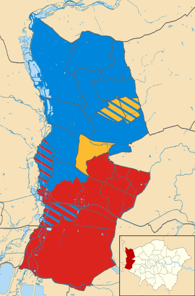
Borough of Hillingdon, UK showing the results of the 2002 local election. Colour:
197:
568:
532:
105:
240:
I, the copyright holder of this work, hereby publish it under the following license:
215:
222:
181:
489:
Click on a date/time to view the file as it appeared at that time.
93:
87:(SVG file, nominally 833 × 1,266 pixels, file size: 1.11 MB)
434:
Creative
Commons Attribution-ShareAlike 4.0 International
586:
348:
Add a one-line explanation of what this file represents
137:
117:
Commons is a freely licensed media file repository.
143:Hillingdon London UK local election 2002 map.svg
554:2002 Hillingdon London Borough Council election
316:https://creativecommons.org/licenses/by-sa/4.0
98:
322:Creative Commons Attribution-Share Alike 4.0
246:
8:
564:Hillingdon London Borough Council elections
282:– to copy, distribute and transmit the work
46:Size of this PNG preview of this SVG file:
604:
491:
344:
579:The following other wikis use this file:
269:Attribution-Share Alike 4.0 International
172:Striped wards have mixed representation.
614:
606:
551:
467:
451:
431:
415:
395:
379:
362:
359:
340:
333:
212:Hillingdon London UK blank ward map.svg
193:Hillingdon London UK blank ward map.svg
549:The following 4 pages use this file:
7:
218:, created using Ordnance Survey data
539:User created page with UploadWizard
480:
257:
252:
597:
353:
347:
243:
239:
147:
130:
80:
352:
338:
293:Under the following conditions:
264:This file is licensed under the
256:
251:
245:
196:
97:
31:
21:
335:
148:
14:
334:
26:
1:
191:This file was derived from:
36:
360:Items portrayed in this file
559:2002 London local elections
636:
583:Usage on www.wikidata.org
307:same or compatible license
481:
16:
337:
273:
104:This is a file from the
538:
205:
187:
180:
177:
140:
108:. Information from its
111:description page there
70:1,347 × 2,048 pixels
517:22:35, 6 March 2015
288:– to adapt the work
52:Other resolutions:
74:833 × 1,266 pixels
66:674 × 1,024 pixels
623:
622:
575:Global file usage
542:
418:copyright license
346:
230:
229:
221:derivative work:
126:
125:
106:Wikimedia Commons
32:Global file usage
627:
605:
529:
382:copyright status
329:
326:
323:
320:
317:
309:as the original.
266:Creative Commons
260:
259:
255:
254:
249:
248:
200:
183:
170:Liberal Democrat
152:
144:
138:
122:
101:
100:
94:
88:
77:
62:505 × 768 pixels
58:316 × 480 pixels
54:158 × 240 pixels
48:394 × 599 pixels
635:
634:
630:
629:
628:
626:
625:
624:
593:
573:
543:
535:
527:
483:
482:
479:
478:
477:
476:
475:
474:
473:
472:
470:
460:
459:
458:
456:
445:
444:
443:
442:
441:
440:
439:
438:
436:
424:
423:
422:
420:
409:
408:
407:
406:
405:
404:
403:
402:
400:
388:
387:
386:
384:
373:
372:
371:
370:
369:
367:
351:
350:
349:
332:
331:
330:
327:
324:
321:
318:
315:
314:
272:
261:
242:
241:
236:
231:
173:
171:
169:
165:
163:
159:
157:
142:
135:
128:
127:
116:
115:
114:is shown below.
90:
86:
79:
78:
51:
12:
11:
5:
633:
631:
621:
620:
617:
613:
612:
609:
596:
592:
591:
590:
589:
577:
576:
572:
571:
566:
561:
556:
547:
546:
541:
540:
537:
533:
530:
524:
519:
514:
510:
509:
506:
503:
500:
497:
494:
487:
486:
471:
468:
466:
465:
464:
463:
462:
461:
457:
452:
450:
449:
448:
447:
446:
437:
432:
430:
429:
428:
427:
426:
425:
421:
416:
414:
413:
412:
411:
410:
401:
396:
394:
393:
392:
391:
390:
389:
385:
380:
378:
377:
376:
375:
374:
368:
363:
361:
358:
357:
356:
355:
354:
343:
342:
339:
336:
313:
312:
311:
310:
300:
291:
290:
289:
283:
276:You are free:
263:
262:
244:
238:
237:
235:
232:
228:
227:
226:
225:
219:
207:
203:
202:
189:
185:
184:
179:
175:
174:
167:
166:
161:
160:
155:
154:
145:
136:
134:
131:
129:
124:
123:
102:
92:
91:
45:
41:
40:
39:
34:
29:
24:
19:
13:
10:
9:
6:
4:
3:
2:
632:
618:
615:
610:
607:
603:
600:
594:
588:
585:
584:
582:
581:
580:
574:
570:
569:User:Doc77can
567:
565:
562:
560:
557:
555:
552:
550:
544:
536:
531:
525:
523:
520:
518:
515:
512:
511:
507:
504:
501:
498:
495:
493:
492:
490:
484:
455:
435:
419:
399:
383:
366:
319:CC BY-SA 4.0
308:
304:
301:
298:
295:
294:
292:
287:
284:
281:
278:
277:
275:
274:
270:
267:
250:
233:
224:
220:
217:
213:
210:
209:
208:
204:
201:
199:
194:
190:
186:
176:
151:
146:
139:
132:
120:
113:
112:
107:
103:
96:
95:
89:
84:
83:Original file
75:
71:
67:
63:
59:
55:
49:
44:
38:
35:
33:
30:
28:
25:
23:
20:
18:
15:
601:
598:
578:
548:
526:833 × 1,266
488:
485:File history
469:6 March 2015
302:
296:
285:
279:
182:6 March 2015
158:Conservative
149:
119:You can help
109:
81:
22:File history
398:copyrighted
303:share alike
297:attribution
141:Description
587:Q122657834
545:File usage
502:Dimensions
27:File usage
528:(1.11 MB)
499:Thumbnail
496:Date/Time
454:inception
234:Licensing
216:Nilfanion
150:English:
595:Metadata
534:Doc77can
341:Captions
286:to remix
280:to share
271:license.
223:Doc77can
37:Metadata
513:current
508:Comment
365:depicts
345:English
195::
133:Summary
85:
616:Height
206:Author
188:Source
168:
164:Labour
162:
156:
608:Width
619:1266
505:User
328:true
325:true
178:Date
17:File
611:833
214::
72:|
68:|
64:|
60:|
56:|
50:.
121:.
76:.
Text is available under the Creative Commons Attribution-ShareAlike License. Additional terms may apply.
