43:
218:
224:
229:
99:
627:
153:
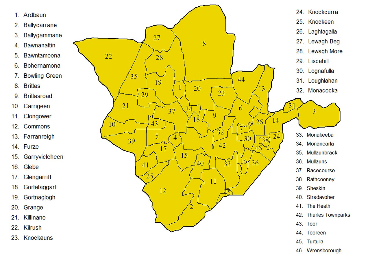
Improved map showing townlands in
Thurles civil parish in North Tipperary, the improvement being to deal correctly with the boundary of that part of Farranreigh that protrudes into Bohernamona. A version of this map without the names is
270:– You must give appropriate credit, provide a link to the license, and indicate if changes were made. You may do so in any reasonable manner, but not in any way that suggests the licensor endorses you or your use.
155:
65:
61:
57:
53:
47:
110:
78:
572:
502:
466:
764:
This file contains additional information, probably added from the digital camera or scanner used to create or digitize it.
277:
386:
556:
450:
422:
407:
394:
379:
522:
486:
352:
335:
626:
621:
69:
42:
414:
658:
239:
767:
If the file has been modified from its original state, some details may not fully reflect the modified file.
166:
in order to decide how to handle the boundary of that part of
Farranreigh that protrudes into Bohernamona.
663:
654:
The following pages on the
English Knowledge (XXG) use this file (pages on other projects are not listed):
276:– If you remix, transform, or build upon the material, you must distribute your contributions under the
236:
429:
118:
751:
637:
175:
163:
159:
195:
105:
211:
I, the copyright holder of this work, hereby publish it under the following license:
668:
594:
Click on a date/time to view the file as it appeared at that time.
93:
158:. Both maps are derived from derived from information in
319:
Add a one-line explanation of what this file represents
83:(2,040 × 1,441 pixels, file size: 1,011 KB, MIME type:
741:
731:
721:
711:
696:
686:
706:
503:
Creative
Commons Attribution-ShareAlike 3.0 Unported
137:
117:
Commons is a freely licensed media file repository.
143:
ImprovedTownlandsWithLegendInThurlesCivilParish.jpg
430:http://commons.wikimedia.org/User:MartinCollin
287:https://creativecommons.org/licenses/by-sa/3.0
98:
293:Creative Commons Attribution-Share Alike 3.0
217:
8:
253:– to copy, distribute and transmit the work
769:
596:
315:
679:The following other wikis use this file:
162:, corrected with information taken from
771:
656:
570:
554:
536:
520:
500:
484:
464:
448:
366:
350:
333:
330:
311:
304:
7:
240:Attribution-Share Alike 3.0 Unported
644:User created page with UploadWizard
585:
228:
223:
762:
324:
318:
214:
210:
147:
130:
76:
323:
309:
264:Under the following conditions:
235:This file is licensed under the
227:
222:
216:
97:
31:
21:
306:
148:
14:
305:
164:this newer Ordnance Survey map
26:
1:
573:original creation by uploader
36:
776:LEAD Technologies Inc. V1.01
380:object of statement has role
331:Items portrayed in this file
176:25 September 2012, 22:17:35
793:
748:Usage on ur.wikipedia.org
738:Usage on sk.wikipedia.org
728:Usage on it.wikipedia.org
718:Usage on gl.wikipedia.org
703:Usage on fr.wikipedia.org
693:Usage on eu.wikipedia.org
683:Usage on cs.wikipedia.org
278:same or compatible license
659:Civil parishes in Ireland
586:
185:
16:
622:21:22, 25 September 2012
308:
244:
160:this Ordnance Survey map
104:This is a file from the
643:
191:
181:
174:
171:
140:
108:. Information from its
664:Thurles (civil parish)
111:description page there
46:Size of this preview:
70:2,040 × 1,441 pixels
259:– to adapt the work
52:Other resolutions:
408:Wikimedia username
395:author name string
66:1,280 × 904 pixels
62:1,024 × 723 pixels
780:
779:
773:JPEG file comment
675:Global file usage
647:
538:25 September 2012
487:copyright license
317:
201:
200:
126:
125:
106:Wikimedia Commons
32:Global file usage
784:
770:
634:
451:copyright status
432:
427:
417:
412:
402:
399:
389:
384:
300:
297:
294:
291:
288:
280:as the original.
237:Creative Commons
231:
230:
226:
225:
220:
219:
187:
177:
152:
144:
138:
122:
101:
100:
94:
88:
86:
73:
58:640 × 452 pixels
54:320 × 226 pixels
48:800 × 565 pixels
792:
791:
787:
786:
785:
783:
782:
781:
758:
673:
655:
648:
640:
632:
588:
587:
584:
583:
582:
581:
580:
579:
578:
577:
575:
563:
562:
561:
559:
548:
547:
546:
545:
544:
543:
542:
541:
539:
529:
528:
527:
525:
514:
513:
512:
511:
510:
509:
508:
507:
505:
493:
492:
491:
489:
478:
477:
476:
475:
474:
473:
472:
471:
469:
457:
456:
455:
453:
442:
441:
440:
439:
438:
437:
436:
435:
434:
433:
428:
425:
419:
418:
413:
410:
404:
403:
400:
397:
391:
390:
385:
382:
373:
372:
371:
369:
359:
358:
357:
355:
344:
343:
342:
341:
340:
338:
322:
321:
320:
303:
302:
301:
298:
295:
292:
289:
286:
285:
243:
232:
213:
212:
207:
202:
167:
142:
135:
128:
127:
116:
115:
114:is shown below.
90:
84:
82:
75:
74:
51:
12:
11:
5:
790:
788:
778:
777:
774:
761:
757:
756:
755:
754:
746:
745:
744:
736:
735:
734:
726:
725:
724:
716:
715:
714:
709:
701:
700:
699:
691:
690:
689:
677:
676:
672:
671:
666:
661:
653:
652:
651:
646:
645:
642:
638:
635:
631:2,040 × 1,441
629:
624:
619:
615:
614:
611:
608:
605:
602:
599:
592:
591:
576:
571:
569:
568:
567:
566:
565:
564:
560:
557:source of file
555:
553:
552:
551:
550:
549:
540:
537:
535:
534:
533:
532:
531:
530:
526:
521:
519:
518:
517:
516:
515:
506:
501:
499:
498:
497:
496:
495:
494:
490:
485:
483:
482:
481:
480:
479:
470:
465:
463:
462:
461:
460:
459:
458:
454:
449:
447:
446:
445:
444:
443:
421:
420:
406:
405:
393:
392:
378:
377:
376:
375:
374:
370:
367:
365:
364:
363:
362:
361:
360:
356:
351:
349:
348:
347:
346:
345:
339:
334:
332:
329:
328:
327:
326:
325:
314:
313:
310:
307:
284:
283:
282:
281:
271:
262:
261:
260:
254:
247:You are free:
234:
233:
215:
209:
208:
206:
203:
199:
198:
193:
189:
188:
183:
179:
178:
173:
169:
168:
156:available here
145:
136:
134:
131:
129:
124:
123:
102:
92:
91:
45:
41:
40:
39:
34:
29:
24:
19:
13:
10:
9:
6:
4:
3:
2:
789:
775:
772:
768:
765:
759:
753:
750:
749:
747:
743:
740:
739:
737:
733:
730:
729:
727:
723:
720:
719:
717:
713:
710:
708:
705:
704:
702:
698:
695:
694:
692:
688:
685:
684:
682:
681:
680:
674:
670:
667:
665:
662:
660:
657:
649:
641:
636:
630:
628:
625:
623:
620:
617:
616:
612:
609:
606:
603:
600:
598:
597:
595:
589:
574:
558:
524:
504:
488:
468:
452:
431:
424:
416:
409:
396:
388:
381:
354:
337:
290:CC BY-SA 3.0
279:
275:
272:
269:
266:
265:
263:
258:
255:
252:
249:
248:
246:
245:
241:
238:
221:
204:
197:
194:
190:
184:
180:
170:
165:
161:
157:
151:
146:
139:
132:
120:
113:
112:
107:
103:
96:
95:
89:
80:
79:Original file
71:
67:
63:
59:
55:
49:
44:
38:
35:
33:
30:
28:
25:
23:
20:
18:
15:
766:
763:
678:
639:MartinCollin
593:
590:File history
415:MartinCollin
401:MartinCollin
387:photographer
273:
267:
256:
250:
196:MartinCollin
149:
119:You can help
109:
77:
22:File history
467:copyrighted
274:share alike
268:attribution
141:Description
650:File usage
633:(1,011 KB)
607:Dimensions
368:some value
85:image/jpeg
27:File usage
752:ٹاؤن لینڈ
604:Thumbnail
601:Date/Time
523:inception
205:Licensing
150:English:
760:Metadata
742:Townland
732:Townland
722:Townland
712:Townland
697:Townland
687:Townland
669:Townland
312:Captions
257:to remix
251:to share
242:license.
186:Own work
37:Metadata
707:Thurles
618:current
613:Comment
353:creator
336:depicts
316:English
133:Summary
81:
192:Author
182:Source
610:User
299:true
296:true
172:Date
17:File
423:URL
426::
411::
398::
383::
68:|
64:|
60:|
56:|
50:.
121:.
87:)
72:.
Text is available under the Creative Commons Attribution-ShareAlike License. Additional terms may apply.
