241:
43:
916:
194:
247:
99:
252:
831:
951:
508:
651:
300:– You must give appropriate credit, provide a link to the license, and indicate if changes were made. You may do so in any reasonable manner, but not in any way that suggests the licensor endorses you or your use.
646:
525:{{Information |Description=Map showing Mountains and Rivers of India |Source=http://en.wikipedia.org/Image:India_Geographic_Map.jpg |Date= |Author=Sagredo |Permission={{GFDL}} |other_versions= }}
578:
821:
791:
611:
756:
583:
941:
936:
911:
1000:
558:
211:
946:
811:
636:
209:; with no Invariant Sections, no Front-Cover Texts, and no Back-Cover Texts. A copy of the license is included in the section entitled
201:
751:
453:
436:
65:
568:
61:
57:
53:
47:
110:
1011:
This file contains additional information, probably added from the digital camera or scanner used to create or digitize it.
400:
307:
78:
206:
420:
384:
177:
548:
261:
1014:
If the file has been modified from its original state, some details may not fully reflect the modified file.
931:
786:
776:
539:
The following pages on the
English Knowledge (XXG) use this file (pages on other projects are not listed):
526:
573:
563:
553:
306:– If you remix, transform, or build upon the material, you must distribute your contributions under the
518:
258:
901:
961:
816:
631:
118:
188:
321:
199:
Permission is granted to copy, distribute and/or modify this document under the terms of the
661:
507:
502:
69:
42:
543:
157:
105:
167:
926:
666:
711:
881:
621:
726:
475:
Click on a date/time to view the file as it appeared at that time.
731:
851:
871:
736:
579:
Knowledge (XXG):Graphics Lab/Images to improve/Archive/Dec 2007
681:
676:
320:
This licensing tag was added to this file as part of the GFDL
235:
93:
976:
981:
584:
Knowledge (XXG):Graphics Lab/Map workshop/Archive/Jan 2010
777:
Wikipédia:Atelier graphique/Cartes/Archives/janvier 2021
601:
360:
Add a one-line explanation of what this file represents
158:
http://en.wikipedia.org/Image:India_Geographic_Map.jpg
741:
83:(1,440 × 1,388 pixels, file size: 809 KB, MIME type:
766:
454:
437:
Creative
Commons Attribution-ShareAlike 3.0 Unported
205:, Version 1.2 or any later version published by the
132:
117:
Commons is a freely licensed media file repository.
891:
801:
701:
991:
971:
861:
841:
721:
691:
917:ആരവല്ലി പർവ്വതനിരകളുടെ ഫലകചലനം മൂലമുള്ള ഉത്ഭവം
327:http://creativecommons.org/licenses/by-sa/3.0/
98:
240:
8:
559:Tectonic evolution of the Aravalli Mountains
333:Creative Commons Attribution-Share Alike 3.0
283:– to copy, distribute and transmit the work
1016:
477:
364:
356:
662:Boscos caducifolis secs del Dècan Central
594:The following other wikis use this file:
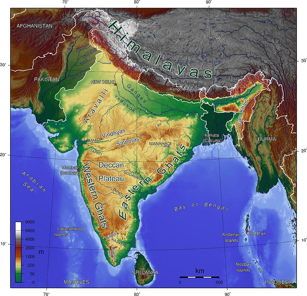
148:Map showing Mountains and Rivers of India
1018:
541:
451:
434:
418:
398:
382:
379:
352:
345:
7:
262:Attribution-Share Alike 3.0 Unported
217:http://www.gnu.org/copyleft/fdl.html
466:
251:
246:
1009:
832:भारत का भूगोल/भारत का भौतिक स्वरूप
373:
367:
359:
142:
130:
76:
372:
350:
294:Under the following conditions:
257:This file is licensed under the
250:
245:
239:
193:
192:
97:
31:
21:
569:User:MathewTownsend/Images/maps
347:
143:
14:
346:
223:GNU Free Documentation License
212:GNU Free Documentation License
202:GNU Free Documentation License
26:
1:
712:Geologie des Aravalligebirges
612:ويكيبيديا:ورشة الصور/أرشيف 17
529:<!--{{ImageUpload|basic}}-
36:
952:विकिपीडिया:मासिक सदर/मे २०१५
667:Monsó del Sud de l'Àsia
380:Items portrayed in this file
898:Usage on mai.wikipedia.org
798:Usage on hif.wikipedia.org
618:Usage on ast.wikipedia.org
1040:
988:Usage on no.wikipedia.org
968:Usage on nn.wikipedia.org
958:Usage on ne.wikipedia.org
923:Usage on mr.wikipedia.org
908:Usage on ml.wikipedia.org
888:Usage on lv.wikipedia.org
878:Usage on ja.wikipedia.org
868:Usage on it.wikibooks.org
858:Usage on io.wikipedia.org
848:Usage on id.wikipedia.org
838:Usage on hu.wikipedia.org
828:Usage on hi.wikibooks.org
808:Usage on hi.wikipedia.org
783:Usage on gu.wikipedia.org
773:Usage on fr.wikipedia.org
763:Usage on fi.wikipedia.org
748:Usage on fa.wikipedia.org
718:Usage on es.wikipedia.org
708:Usage on de.wikipedia.org
698:Usage on da.wikipedia.org
688:Usage on cs.wikiquote.org
673:Usage on cs.wikipedia.org
658:Usage on ca.wikipedia.org
643:Usage on bn.wikipedia.org
628:Usage on bh.wikipedia.org
608:Usage on ar.wikipedia.org
598:Usage on af.wikipedia.org
308:same or compatible license
757:بارانهای موسمی جنوب آسیا
549:List of Russian explorers
467:
266:
238:
16:
349:
207:Free Software Foundation
138:India Geographic Map.jpg
104:This is a file from the
524:
173:
163:
153:
135:
108:. Information from its
527:Category:Maps of India
503:00:03, 17 October 2008
111:description page there
46:Size of this preview:
732:Cordillera de Vindhya
727:Geografía de la India
622:Xeografía de la India
574:User:Sagredo/graphics
564:Talk:India/Archive 55
554:Monsoon of South Asia
168:mukesh Suthar palari
652:আরাবল্লী পর্বতশ্রেণী
70:1,440 × 1,388 pixels
66:1,062 × 1,024 pixels
852:Pegunungan Aravalli
647:সাতপুরা পর্বতশ্রেণী
289:– to adapt the work
52:Other resolutions:
872:Geografia OpenBook
737:Cordillera Satpura
368:Geography of India
1027:
1026:
1001:more global usage
822:सतपुड़ा पर्वतमाला
792:સાતપુડા પર્વતમાળા
590:Global file usage
532:
421:copyright license
366:
358:
344:
343:
234:
233:
183:
182:
126:
125:
106:Wikimedia Commons
32:Global file usage
1031:
1017:
942:विंध्य पर्वतरांग
515:
340:
337:
334:
331:
328:
325:
322:licensing update
310:as the original.
259:Creative Commons
254:
253:
249:
248:
243:
242:
236:
230:
227:
224:
221:
218:
196:
195:
189:
147:
139:
133:
122:
101:
100:
94:
88:
86:
73:
62:797 × 768 pixels
58:498 × 480 pixels
54:249 × 240 pixels
48:622 × 600 pixels
1039:
1038:
1034:
1033:
1032:
1030:
1029:
1028:
1005:
937:अरवली पर्वतरांग
752:کوهستان آراوالی
588:
540:
533:
521:
513:
469:
468:
465:
464:
463:
462:
461:
460:
459:
458:
456:
445:
444:
443:
442:
441:
439:
427:
426:
425:
423:
412:
411:
410:
409:
408:
407:
406:
405:
403:
391:
390:
389:
387:
371:
370:
369:
362:
361:
338:
335:
332:
329:
326:
319:
228:
225:
222:
219:
216:
184:
149:
137:
128:
127:
116:
115:
114:is shown below.
90:
84:
82:
75:
74:
51:
12:
11:
5:
1037:
1035:
1025:
1024:
1021:
1008:
1003:of this file.
997:
996:
995:
994:
986:
985:
984:
979:
977:Aravallifjella
974:
966:
965:
964:
956:
955:
954:
949:
944:
939:
934:
929:
921:
920:
919:
914:
912:സത്പുര പർവതനിര
906:
905:
904:
896:
895:
894:
886:
885:
884:
876:
875:
874:
866:
865:
864:
856:
855:
854:
846:
845:
844:
836:
835:
834:
826:
825:
824:
819:
814:
806:
805:
804:
796:
795:
794:
789:
781:
780:
779:
771:
770:
769:
761:
760:
759:
754:
746:
745:
744:
739:
734:
729:
724:
716:
715:
714:
706:
705:
704:
696:
695:
694:
686:
685:
684:
679:
671:
670:
669:
664:
656:
655:
654:
649:
641:
640:
639:
634:
626:
625:
624:
616:
615:
614:
606:
605:
604:
592:
591:
587:
586:
581:
576:
571:
566:
561:
556:
551:
546:
544:Aravalli Range
538:
537:
536:
531:
530:
523:
519:
516:
512:1,440 × 1,388
510:
505:
500:
496:
495:
492:
489:
486:
483:
480:
473:
472:
457:
452:
450:
449:
448:
447:
446:
440:
435:
433:
432:
431:
430:
429:
428:
424:
419:
417:
416:
415:
414:
413:
404:
399:
397:
396:
395:
394:
393:
392:
388:
383:
381:
378:
377:
376:
375:
374:
363:
355:
354:
351:
348:
342:
341:
316:
315:
314:
313:
312:
311:
301:
292:
291:
290:
284:
277:You are free:
272:
271:
268:
267:
265:
255:
232:
231:
197:
181:
180:
175:
174:Other versions
171:
170:
165:
161:
160:
155:
151:
150:
140:
131:
129:
124:
123:
102:
92:
91:
45:
41:
40:
39:
34:
29:
24:
19:
13:
10:
9:
6:
4:
3:
2:
1036:
1022:
1019:
1015:
1012:
1006:
1004:
1002:
993:
990:
989:
987:
983:
982:Satpurafjella
980:
978:
975:
973:
970:
969:
967:
963:
960:
959:
957:
953:
950:
948:
947:भारताचा भूगोल
945:
943:
940:
938:
935:
933:
930:
928:
925:
924:
922:
918:
915:
913:
910:
909:
907:
903:
900:
899:
897:
893:
890:
889:
887:
883:
880:
879:
877:
873:
870:
869:
867:
863:
860:
859:
857:
853:
850:
849:
847:
843:
840:
839:
837:
833:
830:
829:
827:
823:
820:
818:
815:
813:
812:भारत का भूगोल
810:
809:
807:
803:
800:
799:
797:
793:
790:
788:
785:
784:
782:
778:
775:
774:
772:
768:
765:
764:
762:
758:
755:
753:
750:
749:
747:
743:
740:
738:
735:
733:
730:
728:
725:
723:
720:
719:
717:
713:
710:
709:
707:
703:
700:
699:
697:
693:
690:
689:
687:
683:
680:
678:
675:
674:
672:
668:
665:
663:
660:
659:
657:
653:
650:
648:
645:
644:
642:
638:
635:
633:
630:
629:
627:
623:
620:
619:
617:
613:
610:
609:
607:
603:
600:
599:
597:
596:
595:
589:
585:
582:
580:
577:
575:
572:
570:
567:
565:
562:
560:
557:
555:
552:
550:
547:
545:
542:
534:
528:
522:
517:
511:
509:
506:
504:
501:
498:
497:
493:
490:
487:
484:
481:
479:
478:
476:
470:
455:
438:
422:
402:
401:Sivalik Hills
386:
323:
318:
317:
309:
305:
302:
299:
296:
295:
293:
288:
285:
282:
279:
278:
276:
275:
274:
273:
270:
269:
263:
260:
256:
244:
237:
214:
213:
208:
204:
203:
198:
191:
190:
187:
186:
179:
176:
172:
169:
166:
162:
159:
156:
152:
146:
141:
134:
120:
113:
112:
107:
103:
96:
95:
89:
80:
79:Original file
71:
67:
63:
59:
55:
49:
44:
38:
35:
33:
30:
28:
25:
23:
20:
18:
15:
1013:
1010:
998:
637:सतपुड़ा परबत
593:
474:
471:File history
330:CC BY-SA 3.0
303:
297:
286:
280:
210:
200:
185:
144:
119:You can help
109:
77:
22:File history
304:share alike
298:attribution
136:Description
1020:_error
535:File usage
520:Carlos-PCC
488:Dimensions
85:image/jpeg
27:File usage
485:Thumbnail
482:Date/Time
264:license.
145:English:
1007:Metadata
742:Aravalli
514:(809 KB)
353:Captions
287:to remix
281:to share
37:Metadata
932:सातपुडा
787:અરવલ્લી
767:Satpura
682:Arávalí
677:Sátpurá
499:current
494:Comment
385:depicts
357:English
81:
962:अरावली
902:अरावली
892:Indija
817:अरावली
702:Indien
632:अरावली
164:Author
154:Source
999:View
992:India
972:India
862:India
842:India
802:India
722:India
692:Indie
602:Indië
365:Hindi
178:hindi
927:भारत
491:User
339:true
336:true
229:true
226:true
220:GFDL
17:File
882:インド
68:|
64:|
60:|
56:|
50:.
1023:0
324:.
215:.
121:.
87:)
72:.
Text is available under the Creative Commons Attribution-ShareAlike License. Additional terms may apply.
