43:
197:
203:
208:
91:
661:
730:
740:
249:– You must give appropriate credit, provide a link to the license, and indicate if changes were made. You may do so in any reasonable manner, but not in any way that suggests the licensor endorses you or your use.
145:
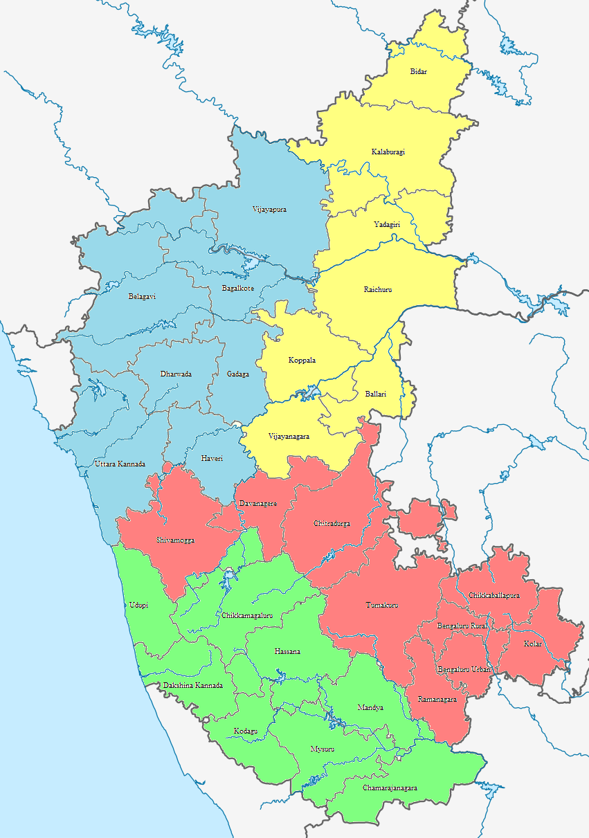
Divisions - Bengaluru
Division (Red), Mysuru Division (Green), Kitturu Karnataka Division (Blue) and Kalyana Karnataka Division (Yellow) along with the 31 districts of Karnataka.
174:
57:
53:
47:
102:
70:
401:
572:
502:
466:
330:
697:
753:
This file contains additional information, probably added from the digital camera or scanner used to create or digitize it.
256:
720:
592:
556:
450:
424:
409:
394:
347:
702:
522:
486:
367:
314:
671:
218:
756:
If the file has been modified from its original state, some details may not fully reflect the modified file.
692:
416:
688:
The following pages on the
English Knowledge (XXG) use this file (pages on other projects are not listed):
255:– If you remix, transform, or build upon the material, you must distribute your contributions under the
215:
660:
655:
61:
42:
110:
97:
190:
I, the copyright holder of this work, hereby publish it under the following license:
154:
628:
Click on a date/time to view the file as it appeared at that time.
85:
503:
Creative
Commons Attribution-ShareAlike 4.0 International
417:
https://commons.wikimedia.org/User:Lokeshwaran_Vela_Rajan
129:
109:
Commons is a freely licensed media file repository.
75:(851 × 1,211 pixels, file size: 345 KB, MIME type:
266:https://creativecommons.org/licenses/by-sa/4.0
90:
272:Creative Commons Attribution-Share Alike 4.0
196:
8:
232:– to copy, distribute and transmit the work
758:
630:
294:
713:The following other wikis use this file:
219:Attribution-Share Alike 4.0 International
768:
760:
690:
606:
590:
570:
554:
536:
520:
500:
484:
464:
448:
381:
365:
345:
328:
312:
309:
290:
283:
7:
298:Divisions and Districts of Karnataka
678:Uploaded own work with UploadWizard
619:
207:
202:
751:
303:
297:
193:
189:
139:
122:
68:
717:Usage on incubator.wikimedia.org
302:
288:
243:Under the following conditions:
214:This file is licensed under the
206:
201:
195:
135:India Karnataka location map.png
89:
31:
21:
285:
140:
14:
698:List of districts of Karnataka
284:
26:
1:
573:original creation by uploader
36:
310:Items portrayed in this file
703:List of taluks of Karnataka
790:
737:Usage on te.wikipedia.org
727:Usage on ta.wikipedia.org
257:same or compatible license
731:கர்நாடக மாவட்டப் பட்டியல்
620:
164:
16:
287:
223:
96:This is a file from the
693:Government of Karnataka
677:
170:
160:
153:
150:
132:
100:. Information from its
741:కర్ణాటక జిల్లాల జాబితా
673:Lokeshwaran Vela Rajan
431:Lokeshwaran Vela Rajan
402:Lokeshwaran Vela Rajan
175:Lokeshwaran Vela Rajan
103:description page there
46:Size of this preview:
762:Horizontal resolution
656:15:19, 16 April 2022
770:Vertical resolution
238:– to adapt the work
52:Other resolutions:
425:author name string
395:Wikimedia username
62:851 × 1,211 pixels
777:
776:
709:Global file usage
681:
487:copyright license
296:
180:
179:
118:
117:
98:Wikimedia Commons
32:Global file usage
781:
759:
668:
451:copyright status
432:
429:
419:
414:
404:
399:
279:
276:
273:
270:
267:
259:as the original.
216:Creative Commons
210:
209:
205:
204:
199:
198:
166:
156:
144:
136:
130:
114:
93:
92:
86:
80:
78:
65:
58:337 × 480 pixels
54:169 × 240 pixels
48:421 × 599 pixels
789:
788:
784:
783:
782:
780:
779:
778:
747:
707:
689:
682:
674:
666:
622:
621:
618:
617:
616:
615:
614:
613:
612:
611:
609:
599:
598:
597:
595:
584:
583:
582:
581:
580:
579:
578:
577:
575:
563:
562:
561:
559:
548:
547:
546:
545:
544:
543:
542:
541:
539:
529:
528:
527:
525:
514:
513:
512:
511:
510:
509:
508:
507:
505:
493:
492:
491:
489:
478:
477:
476:
475:
474:
473:
472:
471:
469:
457:
456:
455:
453:
442:
441:
440:
439:
438:
437:
436:
435:
434:
433:
430:
427:
421:
420:
415:
412:
406:
405:
400:
397:
388:
387:
386:
384:
374:
373:
372:
370:
359:
358:
357:
356:
355:
354:
353:
352:
350:
339:
338:
337:
336:
335:
333:
321:
320:
319:
317:
301:
300:
299:
282:
281:
280:
277:
274:
271:
268:
265:
264:
222:
211:
192:
191:
186:
181:
146:
134:
127:
120:
119:
108:
107:
106:is shown below.
82:
76:
74:
67:
66:
51:
12:
11:
5:
787:
785:
775:
774:
771:
767:
766:
763:
750:
746:
745:
744:
743:
735:
734:
733:
725:
724:
723:
721:Wp/nit/కర్ణాటక
711:
710:
706:
705:
700:
695:
687:
686:
685:
680:
679:
676:
672:
669:
663:
658:
653:
649:
648:
645:
642:
639:
636:
633:
626:
625:
610:
607:
605:
604:
603:
602:
601:
600:
596:
591:
589:
588:
587:
586:
585:
576:
571:
569:
568:
567:
566:
565:
564:
560:
557:source of file
555:
553:
552:
551:
550:
549:
540:
537:
535:
534:
533:
532:
531:
530:
526:
521:
519:
518:
517:
516:
515:
506:
501:
499:
498:
497:
496:
495:
494:
490:
485:
483:
482:
481:
480:
479:
470:
465:
463:
462:
461:
460:
459:
458:
454:
449:
447:
446:
445:
444:
443:
423:
422:
408:
407:
393:
392:
391:
390:
389:
385:
382:
380:
379:
378:
377:
376:
375:
371:
366:
364:
363:
362:
361:
360:
351:
346:
344:
343:
342:
341:
340:
334:
329:
327:
326:
325:
324:
323:
322:
318:
313:
311:
308:
307:
306:
305:
304:
293:
292:
289:
286:
263:
262:
261:
260:
250:
241:
240:
239:
233:
226:You are free:
213:
212:
194:
188:
187:
185:
182:
178:
177:
172:
168:
167:
162:
158:
157:
152:
148:
147:
137:
128:
126:
123:
121:
116:
115:
94:
84:
83:
45:
41:
40:
39:
34:
29:
24:
19:
13:
10:
9:
6:
4:
3:
2:
786:
772:
769:
764:
761:
757:
754:
748:
742:
739:
738:
736:
732:
729:
728:
726:
722:
719:
718:
716:
715:
714:
708:
704:
701:
699:
696:
694:
691:
683:
675:
670:
664:
662:
659:
657:
654:
651:
650:
646:
643:
640:
637:
634:
632:
631:
629:
623:
594:
574:
558:
538:16 April 2022
524:
504:
488:
468:
452:
426:
418:
411:
403:
396:
369:
349:
332:
331:political map
316:
269:CC BY-SA 4.0
258:
254:
251:
248:
245:
244:
242:
237:
234:
231:
228:
227:
225:
224:
220:
217:
200:
183:
176:
173:
169:
163:
159:
155:16 April 2022
149:
143:
138:
131:
124:
112:
105:
104:
99:
95:
88:
87:
81:
72:
71:Original file
63:
59:
55:
49:
44:
38:
35:
33:
30:
28:
25:
23:
20:
18:
15:
755:
752:
712:
665:851 × 1,211
627:
624:File history
252:
246:
235:
229:
141:
111:You can help
101:
69:
22:File history
467:copyrighted
253:share alike
247:attribution
133:Description
684:File usage
641:Dimensions
593:media type
383:some value
27:File usage
638:Thumbnail
635:Date/Time
608:image/png
523:inception
348:Karnataka
184:Licensing
142:English:
77:image/png
773:37.8 dpc
765:37.8 dpc
749:Metadata
667:(345 KB)
291:Captions
236:to remix
230:to share
221:license.
165:Own work
37:Metadata
652:current
647:Comment
368:creator
315:depicts
295:English
125:Summary
73:
171:Author
161:Source
644:User
278:true
275:true
151:Date
17:File
410:URL
428::
413::
398::
60:|
56:|
50:.
113:.
79:)
64:.
Text is available under the Creative Commons Attribution-ShareAlike License. Additional terms may apply.