38:
356:
807:
445:
550:
670:
362:
367:
814:
94:
1180:
1580:
1860:
1150:
448:
The frontiers depicted on the Indian maps in
Knowledge are from a neutral point of view and may differ from official government maps of India, Pakistan and China. Please consult local laws governing publication of maps before
1735:
408:– You must give appropriate credit, provide a link to the license, and indicate if changes were made. You may do so in any reasonable manner, but not in any way that suggests the licensor endorses you or your use.
790:
This map is meant to be for illustrative purpose only and is not authenticated by official government sources. Please check the list of sources and references used to create the map for a measure of accuracy and
834:
administrative boundary recognised by the international community. This UN ceasefire line is considered as a temporary solution to an ongoing conflict since the departure of the
British Raj.
1237:
843:
The depicted extent of the former territory of the
British Indian Empire, succeeded by Republic of India, may not be accepted by few countries as legal due to ongoing border disputes:
794:
The usage of these maps in India, Pakistan and China are governed by different laws that restrict depictions of boundaries other than what is officially recognized by the state.
903:
The borders of the state of
Meghalaya, Assam and Arunachal Pradesh are shown as interpreted from the North-Eastern Areas (Reorganisation) Act, 1971, but has yet to be verified.
1855:
1750:
1500:
1869:
1287:
883:
Minor areas of eastern
Kashmir's Ladakh division, Himachal Pradesh and Uttarakhand on the Chinese frontier are claimed by China. These areas are under Indian control.
1302:
1282:
775:
The territorial boundaries of India are shown as per the actual ground situation in accordance with international practices followed by the United
Nations (
1755:
1462:
1272:
1452:
1247:
1297:
1262:
1252:
782:
68:
64:
1242:
60:
56:
52:
48:
42:
163:
308:
and include a link to this page. No explicit permission is needed from me, but id appreciate an email if my work has been of help to you.
280:
1825:
779:
339:
1267:
1257:
105:
1427:
592:
515:
483:
77:
560:
1417:
1367:
1277:
1061:
1025:
989:
1357:
1457:
1447:
1437:
415:
1422:
1387:
911:
The limit of the territorial waters of India extends to twelve nautical miles measured from the appropriate baseline. See
873:(shown white) is an actively contested region between India and Pakistan. Since 1984, the region is under Indian control.
1412:
1377:
1362:
1307:
1081:
1045:
973:
848:
1179:
1174:
892:
1407:
1352:
1347:
1317:
1292:
1009:
956:
1432:
1397:
1337:
886:
A small area of
Uttarakhand adjoining the Nepal border along the Sarda river is disputed between the two countries.
212:
1382:
1327:
216:
208:
1442:
1372:
1322:
1222:
377:
220:
1710:
1540:
1745:
1730:
1685:
1575:
1560:
1480:
1402:
1342:
1312:
864:
1392:
1332:
414:– If you remix, transform, or build upon the material, you must distribute your contributions under the
824: : The territory India claims is legally theirs, but the claim is disputed by China and Pakistan.
197:
374:
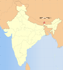
1197:{{WikiProject_India_Maps |Title=Sikkim locator map |Description=Locator map of the state of Sikkim,
1565:
1490:
252:
113:
877:
1227:
1149:
1144:
776:
37:
912:
870:
860:
1845:
256:
1790:
1675:
311:
If you dont want to release your work under a creative commons license, please mail me at
290:
669:
1232:
1205:
1190:
1167:{{Information |Description= |Source= |Date= |Author= |Permission= |other_versions= }}
1160:
852:
100:
349:
I, the copyright holder of this work, hereby publish it under the following license:
1202:
631:
301:
1615:
856:
240:
175:
785:
224:
1625:
1620:
806:
607:
594:
575:
562:
530:
517:
498:
485:
313:
248:
1835:
1610:
1510:
655:
1550:
444:
688:
549:
162:
880:
is almost entirely claimed by China as part of its
Tibetan territory.
319:
149:
127:
1117:
Click on a date/time to view the file as it appeared at that time.
859:). Since 1972, it is divided between all three countries. See also
1700:
1695:
1198:
796:
Please check local laws and modify the map accordingly before use.
694:
204:
193:
1201:
with district boundaries. |Source=. |Date=August 6 2006 |Author=
687:
236:
813:
891:
For a detailed map of all disputed regions in South Asia, see
88:
1770:
232:
82:(SVG file, nominally 1,574 × 1,738 pixels, file size: 836 KB)
1605:
812:
805:
161:
1630:
1238:
Knowledge:Graphics Lab/Images to improve/Archive/Jan 2008
1780:
847:
The northern
Himalayan region of the disputed territory
932:
Add a one-line explanation of what this file represents
720:
640:
If inappropriate please set warp_status = skip to hide.
1665:
1645:
1640:
1800:
1805:
1635:
1600:
1530:
1026:
Creative
Commons Attribution-ShareAlike 3.0 Unported
112:
Commons is a freely licensed media file repository.
1815:
1765:
1720:
1660:
1655:
1650:
1590:
1520:
710:
1288:Knowledge:Userboxes/WikiProjects/alphabetical/25
730:
323:to negotiate a custom license as per your needs.
1861:Китайско-индийский пограничный конфликт (1967)
425:https://creativecommons.org/licenses/by-sa/3.0
93:
1303:Knowledge:WikiProject India/userbox templates
431:Creative Commons Attribution-Share Alike 3.0
355:
8:
1283:Knowledge:Userboxes/WikiProjects/Regional/09
391:– to copy, distribute and transmit the work
41:Size of this PNG preview of this SVG file:
1119:
936:
928:
1846:Conflito fronteiriço sino-indiano em 1967
1473:The following other wikis use this file:
1463:Category:Wikipedians interested in Sikkim
1273:Knowledge:Userboxes/Location/India/States
855:) and the Chinese-occupied territory of (
1453:Category:WikiProject Sikkim participants
462:second half of 20 century and 21 century
1248:Knowledge:Userboxes/Life/Citizenship/04
1220:
1095:
1079:
1059:
1043:
1023:
1007:
987:
971:
954:
951:
924:
917:
781:) and the National Geographic Society (
750:
665:
634:Georeference the map in Wikimaps Warper
1218:The following 49 pages use this file:
1298:Knowledge:WikiProject India/Templates
1263:Knowledge:Userboxes/Life/Residence/04
1253:Knowledge:Userboxes/Life/Ethnicity/02
740:
300:If you are using the image under the
7:
1243:Knowledge:Userboxes/Life/Ancestry/06
378:Attribution-Share Alike 3.0 Unported
302:creative commons share alike license
148:Locator map of the state of Sikkim,
1616:Distretto del Sikkim Settentrionale
1108:
940:സിക്കിം ( ഇന്ത്യയിലെ ഒരു സംസ്ഥാനം )
366:
361:
1268:Knowledge:Userboxes/Location/India
1258:Knowledge:Userboxes/Life/Origin/04
945:
939:
931:
893:Image:India disputed areas map.svg
802:Explanation of disputed boundaries
725:Explanation of disputed boundaries
689:
352:
348:
125:
75:
1428:Template:User interest Sikkim/doc
944:
1626:Distretto del Sikkim Occidentale
1621:Distretto del Sikkim Meridionale
1418:Template:User interest India/doc
1368:Template:User citizen Sikkim/doc
1278:Knowledge:Userboxes/Travel/India
922:
828:Line of Control/Line of Conflict
668:
548:
443:
402:Under the following conditions:
373:This file is licensed under the
365:
360:
354:
273:
92:
31:
21:
1358:Template:User citizen India/doc
919:
851:is claimed by India including (
205:University of Texas map library
194:University of Texas map library
14:
1611:Distretto del Sikkim Orientale
1458:Category:Wikipedians in Sikkim
1448:Category:Sikkimese Wikipedians
1438:Template:User proud Indian/doc
918:
876:The northeastern territory of
230:State and District boundaries:
26:
1:
1581:सिक्किम के राज्यपालों की सूची
1551:Liste des districts du Sikkim
1423:Template:User interest Sikkim
1388:Template:User from Sikkim/doc
1062:original creation by uploader
853:Pakistan-administered Kashmir
632:
1413:Template:User interest India
1378:Template:User from India/doc
1363:Template:User citizen Sikkim
1308:Knowledge:WikiProject Sikkim
952:Items portrayed in this file
770:Depiction of India's borders
715:Depiction of India's borders
276:
253:Survey of India Map Explorer
143:India Sikkim locator map.svg
1822:Usage on pl.wiktionary.org
1797:Usage on pam.wikipedia.org
1707:Usage on mai.wikipedia.org
1537:Usage on dty.wikipedia.org
1527:Usage on cdo.wikipedia.org
1408:Template:User in Sikkim/doc
1353:Template:User citizen India
1348:Template:User WP Sikkim/doc
1318:Template:User IN states/doc
1293:Knowledge:WikiProject India
849:Indian-administered Kashmir
839:Borders of disputed regions
735:Borders of disputed regions
306:CC-by-sa PlaneMad/Wikimedia
1886:
1852:Usage on ru.wikipedia.org
1842:Usage on pt.wikipedia.org
1832:Usage on ps.wikipedia.org
1812:Usage on pl.wikipedia.org
1787:Usage on or.wikipedia.org
1777:Usage on nl.wikipedia.org
1762:Usage on ms.wikipedia.org
1742:Usage on mr.wikipedia.org
1727:Usage on ml.wikipedia.org
1717:Usage on mg.wikipedia.org
1692:Usage on lt.wikipedia.org
1682:Usage on kn.wikipedia.org
1672:Usage on ja.wikipedia.org
1597:Usage on it.wikipedia.org
1587:Usage on is.wikipedia.org
1572:Usage on hi.wikipedia.org
1557:Usage on gu.wikipedia.org
1547:Usage on fr.wikipedia.org
1517:Usage on br.wikipedia.org
1507:Usage on bg.wikipedia.org
1497:Usage on be.wikipedia.org
1487:Usage on ba.wikipedia.org
1477:Usage on as.wikipedia.org
1433:Template:User proud Indian
1398:Template:User in India/doc
1338:Template:User WP India/doc
700:
478:
416:same or compatible license
1383:Template:User from Sikkim
1328:Template:User Sikkim/doc1
1109:
645:
453:
186:
152:with district boundaries.
16:
1856:Штаты и территории Индии
1443:Category:Flora of Sikkim
1373:Template:User from India
1323:Template:User India/doc1
1223:User:ArnabSaha/Userboxes
921:
822:Boundary of Indian claim
467:Spatial reference system
382:
304:please credit the photo
198:India Political map 2001
99:This is a file from the
1501:Штаты і тэрыторыі Індыі
1403:Template:User in Sikkim
1343:Template:User WP Sikkim
1313:Template:User IN states
1196:
1166:
1145:07:16, 29 December 2008
769:
661:
650:
626:
474:
466:
458:
334:
314:arun.planemad@gmail.com
268:
181:
171:
157:
140:
130:
103:. Information from its
1736:സിക്കിം (ലോകസഭാമണ്ഡലം)
1393:Template:User in India
1333:Template:User WP India
915:for more information.
865:Line of Actual Control
817:
810:
656:WikiProject India Maps
454: Geotemporal data
237:2001 Census State Maps
191:International Borders:
166:
106:description page there
816:
809:
262:Map specific sources:
165:
1175:17:55, 6 August 2006
241:Survey of India Maps
69:1,574 × 1,738 pixels
65:1,855 × 2,048 pixels
1208:|Thumbdir=CHANGE }}
646: Archival data
397:– to adapt the work
257:Columbia University
249:US Army Map Service
221:Kashmir Region 2004
217:Western Sector 1988
213:Eastern Sector 1988
209:China-India Borders
47:Other resolutions:
907:Territorial waters
818:
811:
755:Territorial waters
317:or catch me at my
167:
135:Sikkim locator map
61:927 × 1,024 pixels
1870:more global usage
1469:Global file usage
1228:User:Buaidh/Test7
1211:
1010:copyright license
938:
930:
878:Arunachal Pradesh
695:
682:
681:
641:
622:
621:
343:
340:Reusing this file
329:
328:
202:Disputed Borders:
121:
120:
101:Wikimedia Commons
32:Global file usage
1877:
1771:Kemalangan Chola
1701:Čolos incidentas
1696:Sikimo karalystė
1187:
1157:
974:copyright status
899:Internal borders
756:
753:
746:
745:Internal borders
743:
736:
733:
726:
723:
716:
713:
706:
703:
696:
672:
639:
638:
636:
635:
618:
616:
615:
614:
609:
605:
604:
601:
600:
597:
586:
584:
583:
582:
577:
573:
572:
569:
568:
565:
552:
541:
539:
538:
537:
532:
528:
527:
524:
523:
520:
509:
507:
506:
505:
500:
496:
495:
492:
491:
488:
479:
447:
438:
435:
432:
429:
426:
418:as the original.
375:Creative Commons
369:
368:
364:
363:
358:
357:
337:
274:
188:
177:
176:29 December 2008
144:
128:
117:
96:
95:
89:
83:
72:
57:695 × 768 pixels
53:435 × 480 pixels
49:217 × 240 pixels
43:543 × 600 pixels
1885:
1884:
1880:
1879:
1878:
1876:
1875:
1874:
1751:सिक्कीम संस्थान
1606:Template:Sikkim
1467:
1212:
1206:w:user:Planemad
1193:
1185:
1163:
1155:
1111:
1110:
1107:
1106:
1105:
1104:
1103:
1102:
1101:
1100:
1098:
1088:
1087:
1086:
1084:
1073:
1072:
1071:
1070:
1069:
1068:
1067:
1066:
1064:
1052:
1051:
1050:
1048:
1037:
1036:
1035:
1034:
1033:
1032:
1031:
1030:
1028:
1016:
1015:
1014:
1012:
1001:
1000:
999:
998:
997:
996:
995:
994:
992:
980:
979:
978:
976:
965:
964:
963:
962:
961:
959:
943:
942:
941:
934:
933:
909:
901:
871:Siachen glacier
861:Line of Control
841:
804:
772:
767:
762:
754:
751:
744:
741:
734:
731:
724:
721:
714:
711:
704:
701:
697:
693:
683:
676:
673:
633:
630:
612:
610:
606:
602:
598:
595:
593:
591:
580:
578:
574:
570:
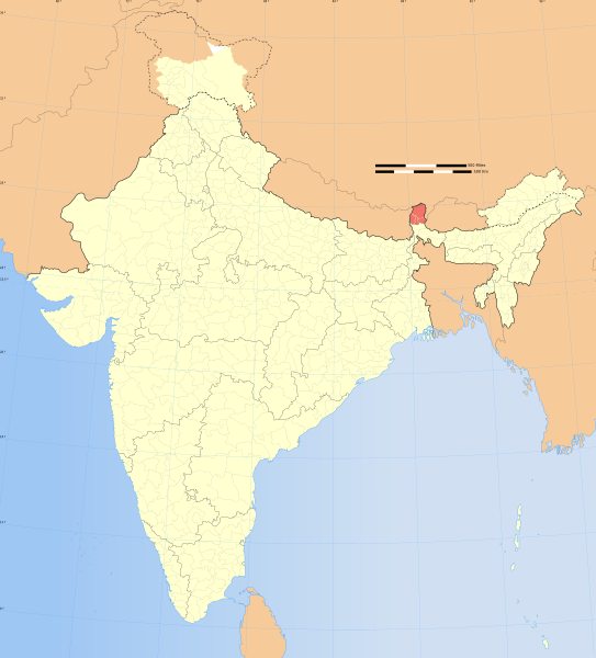
566:
563:
561:
559:
535:
533:
529:
525:
521:
518:
516:
514:
503:
501:
497:
493:
489:
486:
484:
482:
441:
440:
439:
436:
433:
430:
427:
424:
423:
381:
370:
351:
350:
330:
233:Census of India
153:
142:
136:
123:
122:
111:
110:
109:is shown below.
85:
81:
74:
73:
46:
12:
11:
5:
1883:
1881:
1872:of this file.
1866:
1865:
1864:
1863:
1858:
1850:
1849:
1848:
1840:
1839:
1838:
1830:
1829:
1828:
1820:
1819:
1818:
1810:
1809:
1808:
1803:
1795:
1794:
1793:
1785:
1784:
1783:
1775:
1774:
1773:
1768:
1760:
1759:
1758:
1753:
1748:
1740:
1739:
1738:
1733:
1725:
1724:
1723:
1715:
1714:
1713:
1705:
1704:
1703:
1698:
1690:
1689:
1688:
1680:
1679:
1678:
1670:
1669:
1668:
1663:
1658:
1653:
1648:
1643:
1638:
1633:
1628:
1623:
1618:
1613:
1608:
1603:
1595:
1594:
1593:
1585:
1584:
1583:
1578:
1570:
1569:
1568:
1563:
1555:
1554:
1553:
1545:
1544:
1543:
1535:
1534:
1533:
1525:
1524:
1523:
1515:
1514:
1513:
1505:
1504:
1503:
1495:
1494:
1493:
1485:
1484:
1483:
1471:
1470:
1466:
1465:
1460:
1455:
1450:
1445:
1440:
1435:
1430:
1425:
1420:
1415:
1410:
1405:
1400:
1395:
1390:
1385:
1380:
1375:
1370:
1365:
1360:
1355:
1350:
1345:
1340:
1335:
1330:
1325:
1320:
1315:
1310:
1305:
1300:
1295:
1290:
1285:
1280:
1275:
1270:
1265:
1260:
1255:
1250:
1245:
1240:
1235:
1230:
1225:
1216:
1215:
1210:
1209:
1203:w:user:Nichalp
1195:
1191:
1188:
1184:1,639 × 1,852
1182:
1177:
1172:
1169:
1168:
1165:
1161:
1158:
1154:1,574 × 1,738
1152:
1147:
1142:
1138:
1137:
1134:
1131:
1128:
1125:
1122:
1115:
1114:
1099:
1096:
1094:
1093:
1092:
1091:
1090:
1089:
1085:
1080:
1078:
1077:
1076:
1075:
1074:
1065:
1060:
1058:
1057:
1056:
1055:
1054:
1053:
1049:
1046:source of file
1044:
1042:
1041:
1040:
1039:
1038:
1029:
1024:
1022:
1021:
1020:
1019:
1018:
1017:
1013:
1008:
1006:
1005:
1004:
1003:
1002:
993:
988:
986:
985:
984:
983:
982:
981:
977:
972:
970:
969:
968:
967:
966:
960:
955:
953:
950:
949:
948:
947:
946:
935:
927:
926:
923:
920:
908:
905:
900:
897:
888:
887:
884:
881:
874:
868:
857:Ladakh plateau
840:
837:
836:
835:
825:
803:
800:
799:
798:
792:
791:verifiability.
788:
771:
768:
766:
763:
761:
760:
759:
758:
748:
738:
728:
718:
692:
680:
679:
678:
677:
674:
667:
663:
662:Other versions
659:
658:
652:
648:
647:
643:
642:
628:
627:Georeferencing
624:
623:
620:
619:
608:6.25°N 96.09°E
589:
587:
556:
555:
553:
546:
543:
542:
531:37.23°N 99.0°E
512:
510:
499:36.70°N 64.8°E
476:
472:
471:
468:
464:
463:
460:
456:
455:
451:
450:
422:
421:
420:
419:
409:
400:
399:
398:
392:
385:You are free:
372:
371:
353:
347:
346:
344:
332:
331:
327:
326:
325:
324:
309:
286:was created by
277:
272:
270:
266:
265:
246:Other sources:
183:
179:
178:
173:
169:
168:
159:
155:
154:
147:
145:
138:
137:
134:
132:
126:
124:
119:
118:
97:
87:
86:
40:
36:
35:
34:
29:
24:
19:
13:
10:
9:
6:
4:
3:
2:
1882:
1873:
1871:
1862:
1859:
1857:
1854:
1853:
1851:
1847:
1844:
1843:
1841:
1837:
1834:
1833:
1831:
1827:
1824:
1823:
1821:
1817:
1814:
1813:
1811:
1807:
1804:
1802:
1799:
1798:
1796:
1792:
1789:
1788:
1786:
1782:
1779:
1778:
1776:
1772:
1769:
1767:
1764:
1763:
1761:
1757:
1756:चर्चा:सिक्कीम
1754:
1752:
1749:
1747:
1744:
1743:
1741:
1737:
1734:
1732:
1729:
1728:
1726:
1722:
1719:
1718:
1716:
1712:
1709:
1708:
1706:
1702:
1699:
1697:
1694:
1693:
1691:
1687:
1684:
1683:
1681:
1677:
1674:
1673:
1671:
1667:
1664:
1662:
1659:
1657:
1654:
1652:
1649:
1647:
1644:
1642:
1639:
1637:
1634:
1632:
1629:
1627:
1624:
1622:
1619:
1617:
1614:
1612:
1609:
1607:
1604:
1602:
1599:
1598:
1596:
1592:
1589:
1588:
1586:
1582:
1579:
1577:
1574:
1573:
1571:
1567:
1564:
1562:
1559:
1558:
1556:
1552:
1549:
1548:
1546:
1542:
1539:
1538:
1536:
1532:
1529:
1528:
1526:
1522:
1519:
1518:
1516:
1512:
1509:
1508:
1506:
1502:
1499:
1498:
1496:
1492:
1489:
1488:
1486:
1482:
1479:
1478:
1476:
1475:
1474:
1468:
1464:
1461:
1459:
1456:
1454:
1451:
1449:
1446:
1444:
1441:
1439:
1436:
1434:
1431:
1429:
1426:
1424:
1421:
1419:
1416:
1414:
1411:
1409:
1406:
1404:
1401:
1399:
1396:
1394:
1391:
1389:
1386:
1384:
1381:
1379:
1376:
1374:
1371:
1369:
1366:
1364:
1361:
1359:
1356:
1354:
1351:
1349:
1346:
1344:
1341:
1339:
1336:
1334:
1331:
1329:
1326:
1324:
1321:
1319:
1316:
1314:
1311:
1309:
1306:
1304:
1301:
1299:
1296:
1294:
1291:
1289:
1286:
1284:
1281:
1279:
1276:
1274:
1271:
1269:
1266:
1264:
1261:
1259:
1256:
1254:
1251:
1249:
1246:
1244:
1241:
1239:
1236:
1234:
1233:User:RPSkokie
1231:
1229:
1226:
1224:
1221:
1219:
1213:
1207:
1204:
1200:
1194:
1189:
1183:
1181:
1178:
1176:
1173:
1171:
1170:
1164:
1159:
1153:
1151:
1148:
1146:
1143:
1140:
1139:
1135:
1132:
1129:
1126:
1123:
1121:
1120:
1118:
1112:
1097:image/svg+xml
1083:
1063:
1047:
1027:
1011:
991:
975:
958:
916:
914:
906:
904:
898:
896:
895:
894:
885:
882:
879:
875:
872:
869:
866:
862:
858:
854:
850:
846:
845:
844:
838:
833:
829:
826:
823:
820:
819:
815:
808:
801:
797:
793:
789:
786:
783:
780:
777:
774:
773:
764:
757:
749:
747:
739:
737:
729:
727:
719:
717:
709:
708:
707:
699:
698:
690:
686:
685:
671:
666:
664:
660:
657:
653:
649:
644:
637:
629:
625:
617:
590:
588:
585:
576:5.9°N 68.76°E
558:
557:
554:
551:
547:
545:
544:
540:
513:
511:
508:
481:
480:
477:
473:
469:
465:
461:
459:Date depicted
457:
452:
446:
442:
428:CC BY-SA 3.0
417:
413:
410:
407:
404:
403:
401:
396:
393:
390:
387:
386:
384:
383:
379:
376:
359:
345:
341:
336:
333:
322:
321:
316:
315:
310:
307:
303:
299:
298:
297:
296:
293:
292:
291:User:PlaneMad
288:
287:
284:
283:
278:
275:
271:
267:
263:
260:
259:
258:
254:
250:
247:
244:
242:
238:
234:
231:
228:
226:
222:
218:
214:
210:
206:
203:
200:
199:
195:
192:
189:
184:
180:
174:
170:
164:
160:
156:
151:
146:
139:
133:
129:
115:
108:
107:
102:
98:
91:
90:
84:
79:
78:Original file
70:
66:
62:
58:
54:
50:
44:
39:
33:
30:
28:
25:
23:
20:
18:
15:
1867:
1631:Upper Tadong
1472:
1217:
1116:
1113:File history
910:
902:
890:
889:
842:
831:
830: : The
827:
821:
795:
684:
475:Bounding box
411:
405:
394:
388:
318:
312:
305:
294:
289:
285:
281:
279:
261:
245:
229:
225:Kashmir Maps
201:
190:
185:
114:You can help
104:
76:
22:File history
1781:Zuid-Sikkim
990:copyrighted
613:6.25; 96.09
536:37.23; 99.0
504:36.70; 64.8
412:share alike
406:attribution
141:Description
1826:འབྲས་ལྗོངས
1214:File usage
1130:Dimensions
1082:media type
581:5.9; 68.76
335:Permission
282:This Image
158:Map legend
27:File usage
1666:Nayabazar
1646:Jorethang
1641:Gyalshing
1491:Һиндостан
1127:Thumbnail
1124:Date/Time
937:Malayalam
675:blank map
1192:Planemad
1186:(751 KB)
1162:Planemad
1156:(836 KB)
925:Captions
832:de facto
691:Contents
654:Part of
395:to remix
389:to share
380:license.
187:Own work
1801:Gangtok
1746:सिक्कीम
1731:സിക്കിം
1711:गान्टोक
1686:ಸಿಕ್ಕಿಂ
1636:Singtam
1601:Gangtok
1576:गान्तोक
1561:સિક્કિમ
1541:गान्तोक
1481:ছিক্কিম
1141:current
1136:Comment
957:depicts
929:English
599:96°05′E
567:68°46′E
522:99°00′E
519:37°14′N
490:64°48′E
487:36°42′N
320:Website
269:Creator
80:
1816:Sikkim
1806:Sikkim
1766:Sikkim
1721:Sikkim
1661:Rangpo
1656:Namchi
1651:Mangan
1591:Sikkim
1566:ગંગટોક
1531:Sikkim
1521:Sikkim
596:6°15′N
564:5°54′N
449:usage.
215:&
182:Source
1868:View
1836:سيکيم
1791:ସିକିମ
1676:シッキム州
1511:Сиким
1199:India
765:Notes
705:Notes
651:Notes
470:conic
150:India
131:Title
1133:User
913:this
863:and
437:true
434:true
172:Date
17:File
752:1.5
742:1.4
732:1.3
722:1.2
712:1.1
603:/
571:/
526:/
494:/
784:,
778:,
611:/
579:/
534:/
502:/
255:,
251:,
239:-
235:-
223:-
219:-
211:-
207:-
196:-
67:|
63:|
59:|
55:|
51:|
45:.
867:.
787:)
702:1
342:)
338:(
295:.
264:.
243:.
227:.
116:.
71:.
Text is available under the Creative Commons Attribution-ShareAlike License. Additional terms may apply.

