43:
703:
276:
578:
405:
709:
1254:
714:
585:
99:
509:
480:
1324:
1179:
1046:
1304:
1189:
1319:
1016:
1199:
1314:
408:
The frontiers depicted on the Indian maps in
Knowledge are from a neutral point of view and may differ from official government maps of India, Pakistan and China. Please consult local laws governing publication of maps before
755:– You must give appropriate credit, provide a link to the license, and indicate if changes were made. You may do so in any reasonable manner, but not in any way that suggests the licensor endorses you or your use.
561:
This map is meant to be for illustrative purpose only and is not authenticated by official government sources. Please check the list of sources and references used to create the map for a measure of accuracy and
1204:
1214:
1174:
605:
administrative boundary recognised by the international community. This UN ceasefire line is considered as a temporary solution to an ongoing conflict since the departure of the
British Raj.
492:
614:
The depicted extent of the former territory of the
British Indian Empire, succeeded by Republic of India, may not be accepted by few countries as legal due to ongoing border disputes:
565:
The usage of these maps in India, Pakistan and China are governed by different laws that restrict depictions of boundaries other than what is officially recognized by the state.
674:
The borders of the state of
Meghalaya, Assam and Arunachal Pradesh are shown as interpreted from the North-Eastern Areas (Reorganisation) Act, 1971, but has yet to be verified.
654:
Minor areas of eastern
Kashmir's Ladakh division, Himachal Pradesh and Uttarakhand on the Chinese frontier are claimed by China. These areas are under Indian control.
1224:
1239:
1339:
546:
The territorial boundaries of India are shown as per the actual ground situation in accordance with international practices followed by the United
Nations (
261:
1244:
1063:{{WikiProject_India_Maps |Title=India map disputed areas |Description=Map showing disputed areas of India. |Source=. |Date=July 31 2006 |Author=
1101:
553:
73:
69:
65:
61:
57:
53:
47:
550:
396:
110:
1234:
82:
925:
889:
853:
1081:
1382:
This file contains additional information, probably added from the digital camera or scanner used to create or digitize it.
1334:
1279:
762:
1091:
682:
The limit of the territorial waters of India extends to twelve nautical miles measured from the appropriate baseline. See
644:(shown white) is an actively contested region between India and Pakistan. Since 1984, the region is under Indian control.
1106:
961:
909:
837:
619:
1045:
1040:
945:
873:
820:
657:
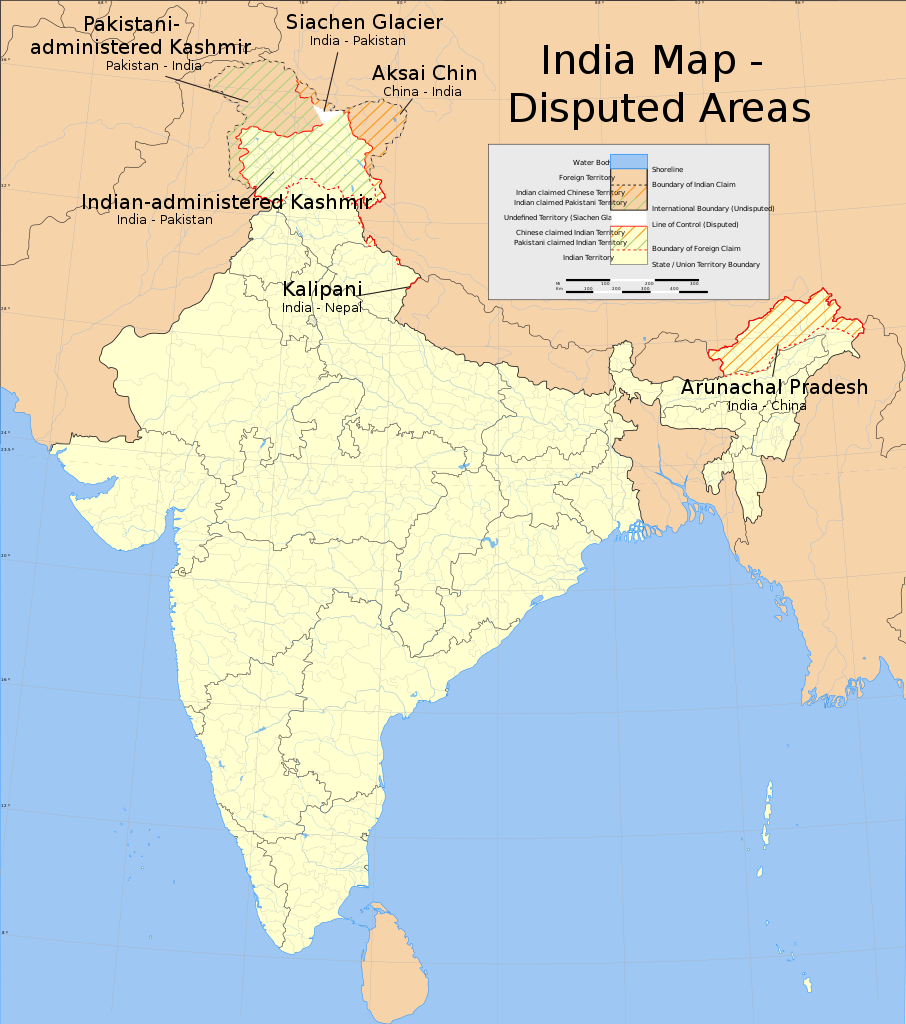
A small area of
Uttarakhand adjoining the Nepal border along the Sarda river is disputed between the two countries.
1086:
323:
327:
319:
724:
331:
1385:
If the file has been modified from its original state, some details may not fully reflect the modified file.
635:
1369:
761:– If you remix, transform, or build upon the material, you must distribute your contributions under the
1349:
595: : The territory India claims is legally theirs, but the claim is disputed by China and Pakistan.
308:
721:
363:
118:
648:
522:
1149:
1015:
1010:
547:
42:
1154:
1096:
683:
641:
631:
367:
384:
1064:
1056:
623:
105:
696:
I, the copyright holder of this work, hereby publish it under the following license:
1026:
439:
1164:
1144:
627:
1124:
351:
286:
556:
335:
275:
577:
1274:
359:
1264:
463:
404:
1294:
132:
1255:Китай потребовал от Индии вывести войска из спорного района в Гималаях
651:
is almost entirely claimed by China as part of its
Tibetan territory.
486:
1134:
1033:
Quickly change the wording in
Kashmir for neutrality and consistency
233:
983:
Click on a date/time to view the file as it appeared at that time.
630:). Since 1972, it is divided between all three countries. See also
804:
Above As shown above, the map of India is marked by POK, LOC, LAC.
567:
Please check local laws and modify the map accordingly before use.
315:
304:
138:
347:
131:
584:
518:
662:
For a detailed map of all disputed regions in South Asia, see
93:
508:
343:
87:(SVG file, nominally 1,639 × 1,852 pixels, file size: 978 KB)
583:
576:
479:
618:
The northern
Himalayan region of the disputed territory
448:
If inappropriate please set warp_status = skip to hide.
174:
1359:
890:
Creative Commons Attribution-ShareAlike 3.0 Unported
117:
Commons is a freely licensed media file repository.
1289:
1150:Utilisateur:ThBO37/Conflit frontalier sino-indien
164:
262:File:India Pakistan China Disputed Areas Map.png
184:
1155:Liste des territoires contestés de l'Inde
772:https://creativecommons.org/licenses/by-sa/3.0
260:Map showing disputed areas of India. See also
98:
778:Creative Commons Attribution-Share Alike 3.0
702:
8:
738:– to copy, distribute and transmit the work
46:Size of this PNG preview of this SVG file:
1387:
985:
800:
1117:The following other wikis use this file:
626:) and the Chinese-occupied territory of (
422:second half of 20 century and 21 century
1397:
1389:
1325:వికీపీడియా:ఈ వారపు వ్యాసం/2023 37వ వారం
1145:Relations entre la Chine et l'Inde
1079:
959:
943:
923:
907:
887:
871:
851:
835:
818:
815:
796:
789:
552:) and the National Geographic Society (
442:Georeference the map in Wikimaps Warper
204:
1102:List of irredentist claims or disputes
1077:The following 6 pages use this file:
194:
7:
725:Attribution-Share Alike 3.0 Unported
974:
713:
708:
1380:
809:
803:
699:
695:
664:Image:India disputed areas map.svg
573:Explanation of disputed boundaries
513:
484:
254:
179:Explanation of disputed boundaries
133:
130:
80:
1320:వికీపీడియా:ఈ వారం వ్యాసాలు (2023)
808:
794:
749:Under the following conditions:
720:This file is licensed under the
712:
707:
701:
599:Line of Control/Line of Conflict
507:
478:
403:
274:
97:
31:
21:
1275:Indijsko-pakistanski rat (1965)
1180:ಭಾರತದ ಗಡಿಗಳು ಮತ್ತು ನರೆ ರಾಜ್ಯಗಳು
791:
622:is claimed by India including (
316:University of Texas map library
305:University of Texas map library
255:
14:
1265:Drugi indijsko-pakistanski rat
1082:Border Personnel Meeting Point
790:
647:The northeastern territory of
341:State and District boundaries:
216:
26:
1:
1350:Tranh chấp biên giới Ấn-Trung
1305:இந்திய-சீன எல்லைப் பிணக்குகள்
1190:ഇന്ത്യയിലെ തർക്ക ബാധിത മേഖലകൾ
1125:Guerra indo-pakistaní de 1965
1092:Disputed territories of India
926:original creation by uploader
624:Pakistan-administered Kashmir
440:
36:
1295:Indo-pakistanska kriget 1965
1107:List of territorial disputes
816:Items portrayed in this file
541:Depiction of India's borders
364:Survey of India Map Explorer
249:India disputed areas map.svg
169:Depiction of India's borders
144:
1231:Usage on pnb.wikipedia.org
620:Indian-administered Kashmir
610:Borders of disputed regions
189:Borders of disputed regions
1419:
1366:Usage on zh.wikipedia.org
1356:Usage on www.wikidata.org
1346:Usage on vi.wikipedia.org
1331:Usage on ur.wikipedia.org
1311:Usage on te.wikipedia.org
1301:Usage on ta.wikipedia.org
1286:Usage on sv.wikipedia.org
1271:Usage on sr.wikipedia.org
1261:Usage on sh.wikipedia.org
1221:Usage on pa.wikipedia.org
1211:Usage on or.wikipedia.org
1200:भारत-पाकिस्तान दुसरे युद्ध
1196:Usage on mr.wikipedia.org
1186:Usage on ml.wikipedia.org
1171:Usage on kn.wikipedia.org
1161:Usage on ja.wikipedia.org
1141:Usage on fr.wikipedia.org
1131:Usage on fi.wikipedia.org
1121:Usage on es.wikipedia.org
763:same or compatible license
154:
1315:భారత చైనా సరిహద్దు వివాదం
1251:Usage on ru.wikinews.org
975:
485:The source code of this
453:
413:
297:
16:
946:language of work or name
793:
729:
593:Boundary of Indian claim
427:Spatial reference system
309:India Political map 2001
241:India map disputed areas
104:This is a file from the
1135:Luettelo aluekiistoista
1062:
1032:
540:
458:
434:
426:
418:
391:
379:
292:
282:
270:
246:
236:
108:. Information from its
686:for more information.
636:Line of Actual Control
588:
581:
464:WikiProject India Maps
414: Geotemporal data
348:2001 Census State Maps
302:International Borders:
111:description page there
1340:چین بھارت سرحدی تنازع
1240:چین بھارت سرحدی تنازع
1205:चीन-भारतीय सीमा विवाद
1087:China–India relations
587:
580:
373:Map specific sources:
470:SVG development
352:Survey of India Maps
74:1,639 × 1,852 pixels
70:1,812 × 2,048 pixels
1335:پاک بھارت جنگ 1965ء
1245:ہند-چین سرحدی جھگڑا
1215:ଭାରତ-ଚୀନ ସୀମା ବିବାଦ
1175:ಭಾರತ ಚೀನಾ ಗಡಿ ವಿವಾದ
1041:12:55, 31 July 2006
1011:11:51, 10 June 2020
744:– to adapt the work
454: Archival data
368:Columbia University
360:US Army Map Service
332:Kashmir Region 2004
328:Western Sector 1988
324:Eastern Sector 1988
320:China-India Borders
52:Other resolutions:
678:Territorial waters
589:
582:
209:Territorial waters
66:906 × 1,024 pixels
1406:
1405:
1113:Global file usage
1070:
1067:|Thumbdir=a/ab }}
874:copyright license
802:
649:Arunachal Pradesh
532:
531:
523:Adobe Illustrator
521:was created with
449:
400:
397:Reusing this file
313:Disputed Borders:
139:
126:
125:
106:Wikimedia Commons
32:Global file usage
1410:
1388:
1235:بھارت چین تعلقات
1097:Jawaharlal Nehru
1053:
1023:
838:copyright status
785:
782:
779:
776:
773:
765:as the original.
722:Creative Commons
716:
715:
711:
710:
705:
704:
670:Internal borders
511:
502:
496:
482:
447:
446:
444:
443:
407:
394:
299:
288:
278:
259:
250:
234:
222:
219:
210:
207:
200:
199:Internal borders
197:
190:
187:
180:
177:
170:
167:
160:
157:
150:
147:
140:
122:
101:
100:
94:
88:
77:
62:680 × 768 pixels
58:425 × 480 pixels
54:212 × 240 pixels
48:530 × 599 pixels
1418:
1417:
1413:
1412:
1411:
1409:
1408:
1407:
1376:
1111:
1071:
1065:w:user:Planemad
1059:
1051:
1029:
1021:
977:
976:
973:
972:
971:
970:
969:
968:
967:
966:
964:
952:
951:
950:
948:
937:
936:
935:
934:
933:
932:
931:
930:
928:
916:
915:
914:
912:
901:
900:
899:
898:
897:
896:
895:
894:
892:
880:
879:
878:
876:
865:
864:
863:
862:
861:
860:
859:
858:
856:
844:
843:
842:
840:
829:
828:
827:
826:
825:
823:
807:
806:
805:
788:
787:
786:
783:
780:
777:
774:
771:
770:
728:
717:
698:
697:
692:
680:
672:
642:Siachen glacier
632:Line of Control
612:
575:
543:
538:
533:
528:
527:
526:
505:
504:
498:
490:
473:
441:
438:
387:
385:w:user:Planemad
344:Census of India
266:
265:
248:
242:
231:
226:
220:
217:
208:
205:
198:
195:
188:
185:
178:
175:
168:
165:
158:
155:
148:
145:
141:
137:
128:
127:
116:
115:
114:is shown below.
90:
86:
79:
78:
51:
12:
11:
5:
1416:
1414:
1404:
1403:
1400:
1396:
1395:
1392:
1379:
1375:
1374:
1373:
1372:
1364:
1363:
1362:
1354:
1353:
1352:
1344:
1343:
1342:
1337:
1329:
1328:
1327:
1322:
1317:
1309:
1308:
1307:
1299:
1298:
1297:
1292:
1284:
1283:
1282:
1280:Копнена Индија
1277:
1269:
1268:
1267:
1259:
1258:
1257:
1249:
1248:
1247:
1242:
1237:
1229:
1228:
1227:
1225:ਭਾਰਤ–ਚੀਨ ਸੰਬੰਧ
1219:
1218:
1217:
1209:
1208:
1207:
1202:
1194:
1193:
1192:
1184:
1183:
1182:
1177:
1169:
1168:
1167:
1159:
1158:
1157:
1152:
1147:
1139:
1138:
1137:
1129:
1128:
1127:
1115:
1114:
1110:
1109:
1104:
1099:
1094:
1089:
1084:
1075:
1074:
1069:
1068:
1061:
1057:
1054:
1050:1,639 × 1,852
1048:
1043:
1038:
1035:
1034:
1031:
1027:
1024:
1020:1,639 × 1,852
1018:
1013:
1008:
1004:
1003:
1000:
997:
994:
991:
988:
981:
980:
965:
960:
958:
957:
956:
955:
954:
953:
949:
944:
942:
941:
940:
939:
938:
929:
924:
922:
921:
920:
919:
918:
917:
913:
910:source of file
908:
906:
905:
904:
903:
902:
893:
888:
886:
885:
884:
883:
882:
881:
877:
872:
870:
869:
868:
867:
866:
857:
852:
850:
849:
848:
847:
846:
845:
841:
836:
834:
833:
832:
831:
830:
824:
819:
817:
814:
813:
812:
811:
810:
799:
798:
795:
792:
769:
768:
767:
766:
756:
747:
746:
745:
739:
732:You are free:
719:
718:
700:
694:
693:
691:
688:
679:
676:
671:
668:
659:
658:
655:
652:
645:
639:
628:Ladakh plateau
611:
608:
607:
606:
596:
574:
571:
570:
569:
563:
562:verifiability.
559:
542:
539:
537:
534:
530:
529:
506:
477:
476:
474:
471:
467:
466:
460:
456:
455:
451:
450:
436:
435:Georeferencing
432:
431:
428:
424:
423:
420:
416:
415:
411:
410:
401:
389:
388:
383:
381:
377:
376:
357:Other sources:
294:
290:
289:
284:
280:
279:
272:
268:
267:
253:
251:
244:
243:
240:
238:
232:
230:
227:
225:
224:
214:
213:
212:
202:
192:
182:
172:
152:
136:
129:
124:
123:
102:
92:
91:
45:
41:
40:
39:
34:
29:
24:
19:
13:
10:
9:
6:
4:
3:
2:
1415:
1401:
1398:
1393:
1390:
1386:
1383:
1377:
1371:
1368:
1367:
1365:
1361:
1358:
1357:
1355:
1351:
1348:
1347:
1345:
1341:
1338:
1336:
1333:
1332:
1330:
1326:
1323:
1321:
1318:
1316:
1313:
1312:
1310:
1306:
1303:
1302:
1300:
1296:
1293:
1291:
1288:
1287:
1285:
1281:
1278:
1276:
1273:
1272:
1270:
1266:
1263:
1262:
1260:
1256:
1253:
1252:
1250:
1246:
1243:
1241:
1238:
1236:
1233:
1232:
1230:
1226:
1223:
1222:
1220:
1216:
1213:
1212:
1210:
1206:
1203:
1201:
1198:
1197:
1195:
1191:
1188:
1187:
1185:
1181:
1178:
1176:
1173:
1172:
1170:
1166:
1163:
1162:
1160:
1156:
1153:
1151:
1148:
1146:
1143:
1142:
1140:
1136:
1133:
1132:
1130:
1126:
1123:
1122:
1120:
1119:
1118:
1112:
1108:
1105:
1103:
1100:
1098:
1095:
1093:
1090:
1088:
1085:
1083:
1080:
1078:
1072:
1066:
1060:
1055:
1049:
1047:
1044:
1042:
1039:
1037:
1036:
1030:
1025:
1019:
1017:
1014:
1012:
1009:
1006:
1005:
1001:
998:
995:
992:
989:
987:
986:
984:
978:
963:
947:
927:
911:
891:
875:
855:
839:
822:
775:CC BY-SA 3.0
764:
760:
757:
754:
751:
750:
748:
743:
740:
737:
734:
733:
731:
730:
726:
723:
706:
689:
687:
685:
677:
675:
669:
667:
666:
665:
656:
653:
650:
646:
643:
640:
637:
633:
629:
625:
621:
617:
616:
615:
609:
604:
600:
597:
594:
591:
590:
586:
579:
572:
568:
564:
560:
557:
554:
551:
548:
545:
544:
535:
524:
520:
517:
510:
501:
495:
494:
488:
481:
475:
469:
468:
465:
461:
457:
452:
445:
437:
433:
429:
425:
421:
419:Date depicted
417:
412:
406:
402:
398:
393:
390:
386:
382:
378:
374:
371:
370:
369:
365:
361:
358:
355:
353:
349:
345:
342:
339:
337:
333:
329:
325:
321:
317:
314:
311:
310:
306:
303:
300:
295:
291:
285:
281:
277:
273:
269:
263:
258:
252:
245:
239:
235:
228:
223:
215:
211:
203:
201:
193:
191:
183:
181:
173:
171:
163:
162:
161:
153:
151:
143:
142:
134:
120:
113:
112:
107:
103:
96:
95:
89:
84:
83:Original file
75:
71:
67:
63:
59:
55:
49:
44:
38:
35:
33:
30:
28:
25:
23:
20:
18:
15:
1384:
1381:
1116:
1076:
982:
979:File history
758:
752:
741:
735:
681:
673:
663:
661:
660:
613:
602:
601: : The
598:
592:
566:
515:
499:
491:
372:
356:
340:
336:Kashmir Maps
312:
301:
296:
287:31 July 2006
256:
119:You can help
109:
81:
22:File history
1370:Talk:中印边界问题
854:copyrighted
759:share alike
753:attribution
247:Description
1073:File usage
996:Dimensions
392:Permission
271:Map legend
27:File usage
993:Thumbnail
990:Date/Time
690:Licensing
514:This W3C-
472:InfoField
257:English:
221:Licensing
1378:Metadata
1360:Q5308408
1058:Planemad
1052:(978 KB)
1022:(978 KB)
797:Captions
742:to remix
736:to share
727:license.
603:de facto
462:Part of
298:Own work
135:Contents
37:Metadata
1402:1852.41
1394:1638.55
1028:Uanfala
1007:current
1002:Comment
962:English
821:depicts
801:English
516:invalid
503:errors.
497:due to
493:invalid
380:Creator
229:Summary
149:Summary
85:
1399:Height
512:
483:
409:usage.
326:&
293:Source
1391:Width
536:Notes
459:Notes
430:conic
237:Title
159:Notes
1290:1965
1165:印パ戦争
999:User
784:true
781:true
684:this
634:and
283:Date
17:File
519:map
489:is
487:SVG
206:2.5
196:2.4
186:2.3
176:2.2
166:2.1
555:,
549:,
366:,
362:,
350:-
346:-
334:-
330:-
322:-
318:-
307:-
72:|
68:|
64:|
60:|
56:|
50:.
638:.
558:)
525:.
500:4
399:)
395:(
375:.
354:.
338:.
264:.
218:3
156:2
146:1
121:.
76:.
Text is available under the Creative Commons Attribution-ShareAlike License. Additional terms may apply.

