38:
291:
566:
230:
98:
161:
Data
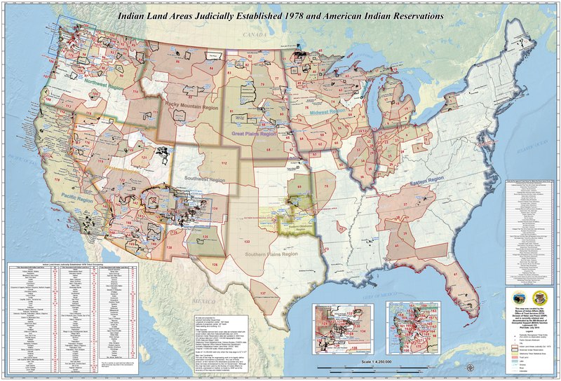
Sources: 1:10M Satellite-derived land cover data and shaded relief with ocean bottom data from NaturalEarthData.com 2015; American Indian Reservation data last updated in 2005 from US Census data and USGS 1:24,000 topographic maps; "ESRI Data and Maps" 2008; Oklahoma Tribal Statistical Area:
68:
64:
60:
56:
52:
48:
42:
109:
77:
154:
This map was created by the Bureau of Indian
Affairs (BIA) Office of Trust Services (OTS) Division of Water and Power (DWP) and is currently retained and disseminated by the BIA Branch of Geospatial Support (BOGS) function, Lakewood, CO.
583:
Uploaded a work by United States of
America. Bureau of Indian Affairs. from https://www.bia.gov/sites/bia_prod.opengov.ibmcloud.com/files/assets/public/pdf/Indian_Land_Areas_Judicially_Established_1978_and_AI_Reservations.pdf with
183:
248:
243:
184:
https://www.bia.gov/sites/bia_prod.opengov.ibmcloud.com/files/assets/public/pdf/Indian_Land_Areas_Judicially_Established_1978_and_AI_Reservations.pdf
565:
560:
37:
269:, commonwealth, county, municipality, or any other subdivision. This template also does not apply to postage stamp designs published by the
339:
Map of Indian Land Areas
Judicially Established by 1978, as determined by the Indian Claims Commission, and American Indian Reservations
162:
Census Bureau (TIGER) data, Eastern
Regional Office Natural Resources Department; Judicially Established Indian Land Area: USGS, 1993
273:
301:
This file has been identified as being free of known restrictions under copyright law, including all related and neighboring rights.
442:
371:
609:
This file contains additional information, probably added from the digital camera or scanner used to create or digitize it.
407:
270:
497:
420:
391:
463:
435:
355:
427:
244:
work prepared by an officer or employee of the United States
Government as part of that person’s official duties
598:
266:
629:
612:
If the file has been modified from its original state, some details may not fully reflect the modified file.
277:
261:: This only applies to original works of the Federal Government and not to the work of any individual
280:
of
Compendium of U.S. Copyright Office Practices). It also does not apply to certain US coins; see
252:
117:
238:
300:
104:
142:
Indian Land Areas
Judicially Established 1978 and American Indian Reservations.pdf
262:
576:
281:
152:
Indian Land Areas
Judicially Established 1978 and American Indian Reservations
173:
533:
Click on a date/time to view the file as it appeared at that time.
224:
92:
289:
82:(7,050 × 4,797 pixels, file size: 11.11 MB, MIME type:
136:
116:
Commons is a freely licensed media file repository.
443:
work of the federal government of the United States
193:
United States of
America. Bureau of Indian Affairs.
309:https://creativecommons.org/publicdomain/mark/1.0/
164:(Original 1:4,000,000 scale; Albers projection).
97:
8:
41:Size of this JPG preview of this PDF file:
614:
535:
335:
204:
666:
658:
650:
642:
634:
624:
616:
596:
511:
495:
477:
461:
405:
389:
372:Indian reservation of the United States
369:
353:
350:
331:
324:
315:Creative Commons Public Domain Mark 1.0
242:in the United States because it is a
229:
7:
594:The following page uses this file:
524:
607:
344:
338:
235:
146:
129:
75:
343:
329:
249:Title 17, Chapter 1, Section 105
228:
96:
21:
644:Date metadata was last modified
326:
147:
14:
325:
26:
1:
31:
351:Items portrayed in this file
271:United States Postal Service
618:Date and time of digitizing
688:
636:File change date and time
525:
299:
16:
599:Indian Claims Commission
428:United States of America
328:
282:The US Mint Terms of Use
103:This is a file from the
630:Esri ArcMap 10.2.2.3552
582:
421:applies to jurisdiction
189:
179:
172:
169:
139:
107:. Information from its
647:03:35, 28 October 2015
639:03:35, 28 October 2015
561:17:13, 12 October 2021
294:
110:description page there
668:Version of PDF format
293:
158:Plot Date: July 2015
436:determination method
236:This work is in the
69:7,050 × 4,797 pixels
65:2,560 × 1,742 pixels
621:08:19, 17 July 2015
246:under the terms of
47:Other resolutions:
663:3384 x 2303.26 pts
295:
61:1,280 × 871 pixels
57:1,024 × 697 pixels
675:
674:
587:
337:
306:
305:
285:
223:
222:
197:
196:
125:
124:
105:Wikimedia Commons
679:
615:
573:
445:
440:
430:
425:
392:copyright status
322:
319:
316:
313:
310:
292:
257:
232:
231:
225:
219:
216:
213:
210:
205:
175:
151:
143:
137:
121:
100:
99:
93:
87:
85:
72:
53:640 × 435 pixels
49:320 × 218 pixels
43:800 × 544 pixels
687:
686:
682:
681:
680:
678:
677:
676:
603:
588:
579:
571:
527:
526:
523:
522:
521:
520:
519:
518:
517:
516:
514:
513:application/pdf
504:
503:
502:
500:
489:
488:
487:
486:
485:
484:
483:
482:
480:
470:
469:
468:
466:
455:
454:
453:
452:
451:
450:
449:
448:
447:
446:
441:
438:
432:
431:
426:
423:
414:
413:
412:
410:
398:
397:
396:
394:
383:
382:
381:
380:
379:
378:
377:
376:
374:
362:
361:
360:
358:
342:
341:
340:
320:
317:
314:
311:
308:
290:
286:
217:
214:
211:
208:
203:
198:
165:
141:
134:
127:
126:
115:
114:
113:is shown below.
89:
84:application/pdf
83:
81:
74:
73:
46:
12:
11:
5:
685:
683:
673:
672:
669:
665:
664:
661:
657:
656:
653:
649:
648:
645:
641:
640:
637:
633:
632:
627:
623:
622:
619:
606:
602:
601:
592:
591:
586:
585:
581:
577:
574:
570:7,050 × 4,797
568:
563:
558:
554:
553:
550:
547:
544:
541:
538:
531:
530:
515:
512:
510:
509:
508:
507:
506:
505:
501:
496:
494:
493:
492:
491:
490:
481:
478:
476:
475:
474:
473:
472:
471:
467:
462:
460:
459:
458:
457:
456:
434:
433:
419:
418:
417:
416:
415:
411:
406:
404:
403:
402:
401:
400:
399:
395:
390:
388:
387:
386:
385:
384:
375:
370:
368:
367:
366:
365:
364:
363:
359:
354:
352:
349:
348:
347:
346:
345:
334:
333:
330:
327:
304:
303:
297:
296:
287:
233:
221:
220:
202:
199:
195:
194:
191:
187:
186:
181:
177:
176:
171:
167:
166:
144:
135:
133:
130:
128:
123:
122:
101:
91:
90:
40:
36:
35:
34:
29:
24:
19:
13:
10:
9:
6:
4:
3:
2:
684:
670:
667:
662:
659:
654:
651:
646:
643:
638:
635:
631:
628:
626:Software used
625:
620:
617:
613:
610:
604:
600:
597:
595:
589:
580:
575:
569:
567:
564:
562:
559:
556:
555:
551:
548:
545:
542:
539:
537:
536:
534:
528:
499:
465:
444:
437:
429:
422:
409:
408:public domain
393:
373:
357:
323:
302:
298:
288:
283:
279:
275:
272:
268:
264:
260:
255:
254:
250:
245:
241:
240:
239:public domain
234:
227:
226:
212:Public domain
209:Public domain
207:
206:
200:
192:
188:
185:
182:
178:
168:
163:
159:
156:
150:
145:
138:
131:
119:
112:
111:
106:
102:
95:
94:
88:
79:
78:Original file
70:
66:
62:
58:
54:
50:
44:
39:
33:
30:
28:
25:
23:
20:
18:
15:
611:
608:
593:
584:UploadWizard
532:
529:File history
307:
258:
247:
237:
160:
157:
153:
148:
118:You can help
108:
76:
22:File history
278:313.6(C)(1)
140:Description
590:File usage
572:(11.11 MB)
546:Dimensions
498:media type
274:since 1978
263:U.S. state
27:File usage
660:Page size
652:Encrypted
543:Thumbnail
540:Date/Time
464:inception
276:. (See §
267:territory
201:Licensing
149:English:
605:Metadata
332:Captions
32:Metadata
557:current
552:Comment
356:depicts
336:English
253:US Code
251:of the
132:Summary
80:
578:Carwil
190:Author
180:Source
321:false
318:false
218:false
215:false
549:User
479:2015
259:Note
174:2015
170:Date
17:File
671:1.6
312:PDM
655:no
439::
424::
265:,
256:.
67:|
63:|
59:|
55:|
51:|
45:.
284:.
120:.
86:)
71:.
Text is available under the Creative Commons Attribution-ShareAlike License. Additional terms may apply.