43:
229:
235:
240:
99:
623:
1138:
1153:
1148:
1143:
1133:
1128:
1123:
1118:
1113:
1108:
1103:
1098:
1093:
1088:
1083:
1078:
1073:
1068:
1063:
1058:
1053:
281:– You must give appropriate credit, provide a link to the license, and indicate if changes were made. You may do so in any reasonable manner, but not in any way that suggests the licensor endorses you or your use.
1043:
1160:
651:
1193:
1048:
1442:
1038:
73:
69:
65:
61:
57:
53:
47:
110:
82:
793:
568:
498:
462:
1453:
This file contains additional information, probably added from the digital camera or scanner used to create or digitize it.
288:
552:
446:
418:
403:
390:
518:
482:
363:
346:
828:
728:
410:
763:
703:
1188:
983:
953:
948:
250:
1456:
If the file has been modified from its original state, some details may not fully reflect the modified file.
963:
943:
748:
650:
More than 100 pages use this file. The following list shows the first 100 pages that use this file only. A
1018:
973:
818:
713:
708:
863:
658:
287:– If you remix, transform, or build upon the material, you must distribute your contributions under the
633:
1003:
958:
883:
247:
743:
678:
622:
617:
42:
1213:
1023:
938:
898:
718:
688:
425:
118:
1183:
1178:
1198:
888:
848:
858:
798:
723:
913:
823:
808:
903:
663:
206:
105:
222:
I, the copyright holder of this work, hereby publish it under the following license:
1008:
933:
928:
878:
738:
698:
673:
783:
773:
683:
186:
978:
968:
788:
768:
155:
Geographic
Coordinate System WGS 1984 (EPSG: 4326) Equirectangular Projection
893:
873:
758:
753:
733:
668:
1423:
1268:
1263:
1258:
1253:
1238:
918:
868:
1338:
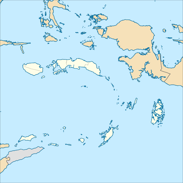
1278:
1293:
1273:
1139:
User:Ty654/List of earthquakes from 2000-present exceeding magnitude 7+
1033:
1028:
988:
923:
853:
833:
803:
778:
693:
1353:
1233:
1013:
998:
908:
843:
838:
1418:
1368:
1248:
1228:
1154:
User:Ty654/List of earthquakes from 2015-2019 exceeding magnitude 6+
1149:
User:Ty654/List of earthquakes from 2010-2014 exceeding magnitude 6+
1144:
User:Ty654/List of earthquakes from 2005-2009 exceeding magnitude 6+
1134:
User:Ty654/List of earthquakes from 2000-2004 exceeding magnitude 6+
1129:
User:Ty654/List of earthquakes from 1995-1999 exceeding magnitude 6+
1124:
User:Ty654/List of earthquakes from 1990-1994 exceeding magnitude 6+
1119:
User:Ty654/List of earthquakes from 1985-1989 exceeding magnitude 6+
1114:
User:Ty654/List of earthquakes from 1980-1984 exceeding magnitude 6+
1109:
User:Ty654/List of earthquakes from 1975-1979 exceeding magnitude 6+
1104:
User:Ty654/List of earthquakes from 1970-1974 exceeding magnitude 6+
1099:
User:Ty654/List of earthquakes from 1965-1969 exceeding magnitude 6+
1094:
User:Ty654/List of earthquakes from 1960-1964 exceeding magnitude 6+
1089:
User:Ty654/List of earthquakes from 1955-1959 exceeding magnitude 6+
1084:
User:Ty654/List of earthquakes from 1950-1999 exceeding magnitude 7+
1079:
User:Ty654/List of earthquakes from 1950-1954 exceeding magnitude 6+
1074:
User:Ty654/List of earthquakes from 1940-1949 exceeding magnitude 6+
1069:
User:Ty654/List of earthquakes from 1930-1939 exceeding magnitude 6+
1064:
User:Ty654/List of earthquakes from 1920-1929 exceeding magnitude 6+
1059:
User:Ty654/List of earthquakes from 1910-1919 exceeding magnitude 6+
1054:
User:Ty654/List of earthquakes from 1900-1949 exceeding magnitude 7+
1343:
1288:
590:
Click on a date/time to view the file as it appeared at that time.
1348:
813:
175:
1044:
User:Ty654/List of earthquakes before 1900 exceeding magnitude 8+
1403:
1358:
993:
1408:
1313:
93:
87:(SVG file, nominally 1,250 × 1,250 pixels, file size: 6.75 MB)
1433:
1413:
1398:
1383:
1323:
1363:
1308:
1303:
1243:
1373:
1393:
1378:
1333:
499:
Creative
Commons Attribution-ShareAlike 4.0 International
1328:
1298:
1428:
1223:
330:
Add a one-line explanation of what this file represents
1318:
1283:
1049:
User:Ty654/List of earthquakes exceeding magnitude 8+
1388:
137:
117:
Commons is a freely licensed media file repository.
1208:
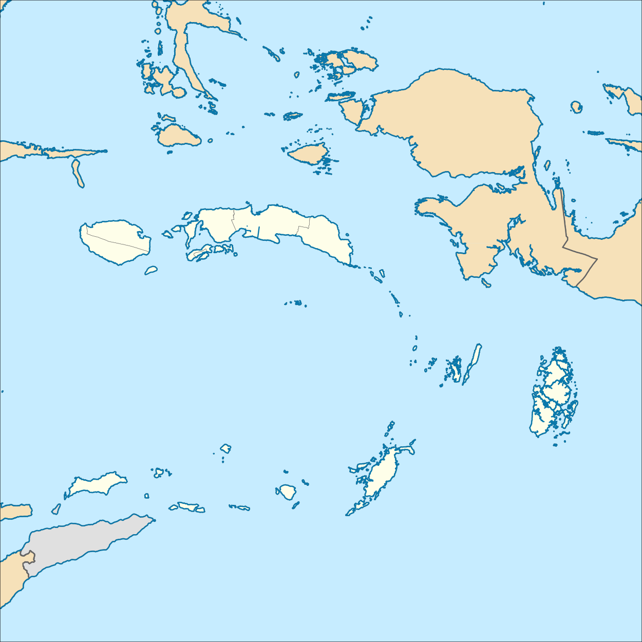
1039:User:Nyanardsan/sandbox/Tanimbar Islands Regency
298:https://creativecommons.org/licenses/by-sa/4.0
98:
426:http://commons.wikimedia.org/User:Mandamaruta
304:Creative Commons Attribution-Share Alike 4.0
228:
8:
264:– to copy, distribute and transmit the work
46:Size of this PNG preview of this SVG file:
1458:
1214:Modèle:Géolocalisation/Moluques (province)
592:
326:
1171:The following other wikis use this file:
251:Attribution-Share Alike 4.0 International
1468:
1460:
656:
566:
550:
532:
516:
496:
480:
460:
444:
377:
361:
344:
341:
322:
315:
7:
794:List of rivers of Maluku (province)
640:User created page with UploadWizard
581:
239:
234:
1451:
335:
329:
225:
221:
153:Location map of Maluku, Indonesia
147:
130:
80:
334:
143:Indonesia Maluku location map.svg
320:
275:Under the following conditions:
246:This file is licensed under the
238:
233:
227:
97:
31:
21:
317:
176:http://tanahair.indonesia.go.id
148:
14:
1424:Bandar Udara Karel Sadsuitubun
1269:Pulau-Pulau Aru, Kepulauan Aru
316:
158:Geographic limits of the map:
26:
1:
569:original creation by uploader
36:
1264:Bandar Udara Sultan Babullah
1259:Kabupaten Seram Bagian Timur
1254:Kabupaten Seram Bagian Barat
1239:Kabupaten Kepulauan Tanimbar
342:Items portrayed in this file
1339:Kabupaten Maluku Barat Daya
1279:Pulau Haruku, Maluku Tengah
1194:پارک ملی اکیتاجائو-لولاباتا
1490:
1294:Gempa bumi Laut Banda 2005
1274:Kota Masohi, Maluku Tengah
1220:Usage on id.wikipedia.org
1205:Usage on fr.wikipedia.org
1175:Usage on fa.wikipedia.org
829:Mathilda Batlayeri Airport
729:Emperor of China (volcano)
289:same or compatible license
1354:Bandar Udara Oesman Sadik
1234:Kabupaten Maluku Tenggara
764:Karel Sadsuitubun Airport
704:Central Halmahera Regency
582:
196:
16:
984:Tanimbar Islands Regency
954:Southwest Maluku Regency
949:Southeast Maluku Regency
319:
255:
104:This is a file from the
1419:Bandar Udara Bandanaira
1369:Taman Nasional Manusela
1249:Kabupaten Kepulauan Aru
1229:Kabupaten Maluku Tengah
964:Sultan Babullah Airport
944:South Halmahera Regency
749:Jos Orno Imsula Airport
639:
618:07:59, 21 December 2017
202:
192:
185:
182:
140:
108:. Information from its
1344:Kabupaten Buru Selatan
1289:Bandar Udara Pattimura
1019:West Halmahera Regency
974:Taliabu Island Regency
819:Manusela National Park
714:East Halmahera Regency
709:Central Maluku Regency
111:description page there
1349:Namrole, Buru Selatan
864:Nieuwerkerk (volcano)
659:1899 Ceram earthquake
1004:Uruangnirin language
959:Sula Islands Regency
884:Oesman Sadik Airport
74:1,250 × 1,250 pixels
70:2,048 × 2,048 pixels
66:1,024 × 1,024 pixels
1404:Pulau Manuk, Maluku
1359:Bandar Udara Namlea
744:John Becker Airport
679:Aru Islands Regency
270:– to adapt the work
52:Other resolutions:
1024:West Seram Regency
939:South Buru Regency
899:Rar Gwamar Airport
719:East Seram Regency
689:Bandanaira Airport
404:Wikimedia username
391:author name string
1477:
1476:
1443:more global usage
1409:Benteng Amsterdam
1314:Pulau Batu Goyang
1167:Global file usage
889:Pattimura Airport
643:
483:copyright license
328:
212:
211:
171:E: 136.0573093° E
168:W: 124.5697609° E
126:
125:
106:Wikimedia Commons
32:Global file usage
1481:
1459:
1434:Bahasa Yalahatan
1414:Benteng Victoria
1399:Emperor of China
1384:Gunung Api Banda
1324:Pulau Panambulai
849:Namniwel Airport
630:
534:21 December 2017
447:copyright status
428:
423:
413:
408:
398:
395:
311:
308:
305:
302:
299:
291:as the original.
248:Creative Commons
242:
241:
237:
236:
231:
230:
198:
188:
187:21 December 2017
165:S: 10.6036373° S
152:
144:
138:
122:
101:
100:
94:
88:
77:
62:768 × 768 pixels
58:480 × 480 pixels
54:240 × 240 pixels
48:600 × 600 pixels
1489:
1488:
1484:
1483:
1482:
1480:
1479:
1478:
1447:
1364:Benteng Belgica
1309:Pulau Batarkusu
1165:
859:Namrole Airport
799:Maba, Indonesia
724:Emalamo Airport
644:
636:
628:
584:
583:
580:
579:
578:
577:
576:
575:
574:
573:
571:
559:
558:
557:
555:
544:
543:
542:
541:
540:
539:
538:
537:
535:
525:
524:
523:
521:
510:
509:
508:
507:
506:
505:
504:
503:
501:
489:
488:
487:
485:
474:
473:
472:
471:
470:
469:
468:
467:
465:
453:
452:
451:
449:
438:
437:
436:
435:
434:
433:
432:
431:
430:
429:
424:
421:
415:
414:
409:
406:
400:
399:
396:
393:
384:
383:
382:
380:
370:
369:
368:
366:
355:
354:
353:
352:
351:
349:
333:
332:
331:
314:
313:
312:
309:
306:
303:
300:
297:
296:
254:
243:
224:
223:
218:
213:
178:
162:N: 0.8839111° N
142:
135:
128:
127:
116:
115:
114:is shown below.
90:
86:
79:
78:
51:
12:
11:
5:
1487:
1485:
1475:
1474:
1471:
1467:
1466:
1463:
1450:
1445:of this file.
1439:
1438:
1437:
1436:
1431:
1426:
1421:
1416:
1411:
1406:
1401:
1396:
1391:
1386:
1381:
1376:
1371:
1366:
1361:
1356:
1351:
1346:
1341:
1336:
1331:
1326:
1321:
1316:
1311:
1306:
1304:Pulau Asutubun
1301:
1296:
1291:
1286:
1281:
1276:
1271:
1266:
1261:
1256:
1251:
1246:
1244:Kabupaten Buru
1241:
1236:
1231:
1226:
1218:
1217:
1216:
1211:
1203:
1202:
1201:
1196:
1191:
1186:
1181:
1169:
1168:
1163:to this file.
1157:
1156:
1151:
1146:
1141:
1136:
1131:
1126:
1121:
1116:
1111:
1106:
1101:
1096:
1091:
1086:
1081:
1076:
1071:
1066:
1061:
1056:
1051:
1046:
1041:
1036:
1031:
1026:
1021:
1016:
1011:
1006:
1001:
996:
991:
986:
981:
976:
971:
966:
961:
956:
951:
946:
941:
936:
931:
926:
921:
916:
914:Sapalewa River
911:
906:
901:
896:
891:
886:
881:
876:
871:
866:
861:
856:
851:
846:
841:
836:
831:
826:
824:Masiwang River
821:
816:
811:
809:Mangole Island
806:
801:
796:
791:
786:
781:
776:
771:
766:
761:
756:
751:
746:
741:
736:
731:
726:
721:
716:
711:
706:
701:
696:
691:
686:
681:
676:
671:
666:
661:
654:is available.
648:
647:
642:
641:
638:
634:
631:
627:1,250 × 1,250
625:
620:
615:
611:
610:
607:
604:
601:
598:
595:
588:
587:
572:
567:
565:
564:
563:
562:
561:
560:
556:
553:source of file
551:
549:
548:
547:
546:
545:
536:
533:
531:
530:
529:
528:
527:
526:
522:
517:
515:
514:
513:
512:
511:
502:
497:
495:
494:
493:
492:
491:
490:
486:
481:
479:
478:
477:
476:
475:
466:
461:
459:
458:
457:
456:
455:
454:
450:
445:
443:
442:
441:
440:
439:
417:
416:
402:
401:
389:
388:
387:
386:
385:
381:
378:
376:
375:
374:
373:
372:
371:
367:
362:
360:
359:
358:
357:
356:
350:
345:
343:
340:
339:
338:
337:
336:
325:
324:
321:
318:
295:
294:
293:
292:
282:
273:
272:
271:
265:
258:You are free:
245:
244:
226:
220:
219:
217:
214:
210:
209:
204:
200:
199:
194:
190:
189:
184:
180:
179:
174:Map data from
173:
172:
169:
166:
163:
145:
136:
134:
131:
129:
124:
123:
102:
92:
91:
45:
41:
40:
39:
34:
29:
24:
19:
13:
10:
9:
6:
4:
3:
2:
1486:
1472:
1469:
1464:
1461:
1457:
1454:
1448:
1446:
1444:
1435:
1432:
1430:
1427:
1425:
1422:
1420:
1417:
1415:
1412:
1410:
1407:
1405:
1402:
1400:
1397:
1395:
1392:
1390:
1387:
1385:
1382:
1380:
1377:
1375:
1374:Bahasa Aputai
1372:
1370:
1367:
1365:
1362:
1360:
1357:
1355:
1352:
1350:
1347:
1345:
1342:
1340:
1337:
1335:
1332:
1330:
1327:
1325:
1322:
1320:
1317:
1315:
1312:
1310:
1307:
1305:
1302:
1300:
1297:
1295:
1292:
1290:
1287:
1285:
1282:
1280:
1277:
1275:
1272:
1270:
1267:
1265:
1262:
1260:
1257:
1255:
1252:
1250:
1247:
1245:
1242:
1240:
1237:
1235:
1232:
1230:
1227:
1225:
1222:
1221:
1219:
1215:
1212:
1210:
1207:
1206:
1204:
1200:
1197:
1195:
1192:
1190:
1187:
1185:
1182:
1180:
1177:
1176:
1174:
1173:
1172:
1166:
1164:
1162:
1155:
1152:
1150:
1147:
1145:
1142:
1140:
1137:
1135:
1132:
1130:
1127:
1125:
1122:
1120:
1117:
1115:
1112:
1110:
1107:
1105:
1102:
1100:
1097:
1095:
1092:
1090:
1087:
1085:
1082:
1080:
1077:
1075:
1072:
1070:
1067:
1065:
1062:
1060:
1057:
1055:
1052:
1050:
1047:
1045:
1042:
1040:
1037:
1035:
1032:
1030:
1027:
1025:
1022:
1020:
1017:
1015:
1012:
1010:
1007:
1005:
1002:
1000:
997:
995:
992:
990:
987:
985:
982:
980:
977:
975:
972:
970:
967:
965:
962:
960:
957:
955:
952:
950:
947:
945:
942:
940:
937:
935:
932:
930:
927:
925:
922:
920:
917:
915:
912:
910:
907:
905:
904:Salawai River
902:
900:
897:
895:
892:
890:
887:
885:
882:
880:
877:
875:
872:
870:
867:
865:
862:
860:
857:
855:
852:
850:
847:
845:
842:
840:
837:
835:
832:
830:
827:
825:
822:
820:
817:
815:
812:
810:
807:
805:
802:
800:
797:
795:
792:
790:
787:
785:
782:
780:
777:
775:
772:
770:
767:
765:
762:
760:
757:
755:
752:
750:
747:
745:
742:
740:
737:
735:
732:
730:
727:
725:
722:
720:
717:
715:
712:
710:
707:
705:
702:
700:
697:
695:
692:
690:
687:
685:
682:
680:
677:
675:
672:
670:
667:
665:
664:Ambon, Maluku
662:
660:
657:
655:
653:
645:
637:
632:
626:
624:
621:
619:
616:
613:
612:
608:
605:
602:
599:
596:
594:
593:
591:
585:
570:
554:
520:
500:
484:
464:
448:
427:
420:
412:
405:
392:
365:
348:
301:CC BY-SA 4.0
290:
286:
283:
280:
277:
276:
274:
269:
266:
263:
260:
259:
257:
256:
252:
249:
232:
215:
208:
205:
201:
195:
191:
181:
177:
170:
167:
164:
161:
160:
159:
156:
151:
146:
139:
132:
120:
113:
112:
107:
103:
96:
95:
89:
84:
83:Original file
75:
71:
67:
63:
59:
55:
49:
44:
38:
35:
33:
30:
28:
25:
23:
20:
18:
15:
1455:
1452:
1440:
1394:Pulau Molana
1379:Bahasa Ambon
1334:Pulau Selaru
1189:توال، مالوکو
1170:
1158:
1009:Waeapo River
934:Sikula River
929:Seram Island
879:Obi (island)
739:Gebe Airport
699:Buru Regency
674:Ambon Island
649:
589:
586:File history
284:
278:
267:
261:
157:
154:
149:
119:You can help
109:
81:
22:File history
1473:999.75118pt
1465:999.75118pt
1329:Pulau Larat
1299:Pulau Liran
1184:تیدور (شهر)
1179:ترنات (شهر)
784:Kola Island
774:Koba Island
684:As language
635:Mandamaruta
463:copyrighted
411:Mandamaruta
397:Mandamaruta
285:share alike
279:attribution
207:Mandamaruta
141:Description
1429:Pantai Ora
1224:Kota Ambon
1161:more links
979:Tanahbesar
969:Tala River
789:Kur Island
769:Kawa River
646:File usage
603:Dimensions
379:some value
27:File usage
1319:Pulau Enu
1284:Kota Tual
1199:تنگه وتار
894:Pekaulang
874:Nusa Laut
759:Kai Kecil
754:Kai Besar
734:Eti River
669:Ambon Bay
652:full list
629:(6.75 MB)
600:Thumbnail
597:Date/Time
519:inception
216:Licensing
150:English:
1449:Metadata
919:Saumlaki
869:Niwelehu
323:Captions
268:to remix
262:to share
253:license.
197:Own work
37:Metadata
1389:Wai Apu
1034:Yaputih
1029:Yamdena
989:Trangan
924:Saunulu
854:Namrole
834:Minggot
804:Maikoor
779:Kobroor
694:Batanta
614:current
609:Comment
364:creator
347:depicts
327:English
133:Summary
85:
1470:Height
1209:Binaya
1014:Waigeo
999:Tulehu
909:Sanana
844:Namlea
839:Misool
203:Author
193:Source
1462:Width
1441:View
1159:View
814:Manuk
994:Tual
606:User
310:true
307:true
183:Date
17:File
419:URL
422::
407::
394::
72:|
68:|
64:|
60:|
56:|
50:.
121:.
76:.
Text is available under the Creative Commons Attribution-ShareAlike License. Additional terms may apply.
