43:
563:
624:
154:
168:
630:
530:
724:
635:
589:
99:
955:
419:
1249:
689:– You must give appropriate credit, provide a link to the license, and indicate if changes were made. You may do so in any reasonable manner, but not in any way that suggests the licensor endorses you or your use.
145:
1561:
573:
1259:
73:
69:
1254:
65:
61:
57:
53:
47:
545:
110:
82:
1297:
1367:
1194:
653:
972:== {{int:filedesc}} == {{Location|36|00|00|N|140|00|00|E|scale:10000}} {{Information |Description= {{fr|Carte topographique vierge de la
478:
577:
562:
657:
516:
832:
796:
161:
1154:
1572:
This file contains additional information, probably added from the digital camera or scanner used to create or digitize it.
696:
500:) as the author and distribute the copies and derivative works under the same license(s) that the one(s) stated below. A
1094:
886:
780:
1174:
852:
816:
763:
645:
541:
501:
1219:
1159:
1009:
973:
954:
949:
537:
42:
1575:
If the file has been modified from its original state, some details may not fully reflect the modified file.
1104:
1362:
1277:
1214:
1054:
1004:
990:
The following pages on the
English Knowledge (XXG) use this file (pages on other projects are not listed):
1352:
1084:
1019:
695:– If you remix, transform, or build upon the material, you must distribute your contributions under the
196:
1244:
407:
1239:
1204:
1184:
1139:
1064:
1059:
642:
467:
224:
1179:
1089:
999:
248:
236:
1069:
1044:
994:
118:
1322:
212:
1129:
1024:
1287:
461:
1229:
1114:
965:
1014:
1224:
1164:
1074:
1039:
598:
259:
167:
1234:
1149:
1109:
1049:
1029:
529:
347:
314: : équirectangulaire + vertical stretching +40% ; système géodésique WGS84
105:
617:
I, the copyright holder of this work, hereby publish it under the following license:
282:
des données topographiques pour les srtm3: 1:372 000 (précision : 93 m) ;
1134:
457:
395:
1402:
379:
1209:
1169:
1124:
1034:
1199:
1189:
1144:
1119:
1099:
438:
602:
390: : données de la carte © les contributeurs d'OpenStreetMap, CC-BY-SA
1079:
271:
388:
Coast, lakes, river, boundaries / Côtes, lacs, cours d'eau, frontières
572:
into your language, using any capable SVG editor, text editor or the
1250:
User:Ty654/List of earthquakes from 2005-2009 exceeding magnitude 6+
557:
151:
977:
922:
Click on a date/time to view the file as it appeared at that time.
200:
1507:
1387:
497:
879:
588:
367:
153:
1442:
391:
1447:
1382:
1312:
136:
93:
87:(SVG file, nominally 1,720 × 2,502 pixels, file size: 2.78 MB)
1542:
980:, destinée à la géolocalisation.}} {{de|Topographische Ka...
286:
of topographic data: 1:372,000 (accuracy : about 93 m);
1492:
1467:
1412:
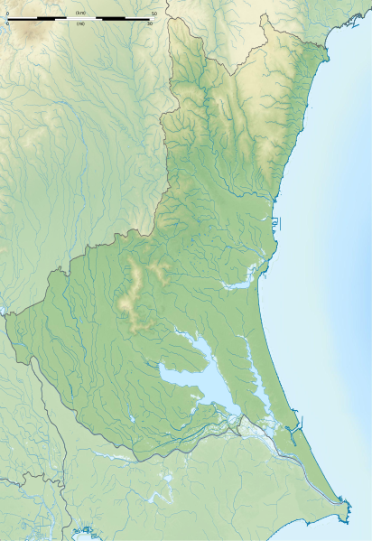
722:
496:
Any use of this image can be made as long as you credit me (
1502:
1462:
1457:
1327:
1307:
146:
36° 00′ 00″ N, 140° 00′ 00″ E
1347:
1547:
1417:
706:
https://creativecommons.org/licenses/by-sa/2.0/fr/deed.en
1517:
1477:
1422:
1337:
504:
with a reply address would also be greatly appreciated.
1532:
1427:
1353:
Plantilla:Mapa de localización de
Prefectura de Ibaraki
747:
Add a one-line explanation of what this file represents
431:
425:
1452:
1432:
1332:
1317:
1527:
1512:
1472:
1392:
1260:
Module:Location map/data/Japan
Ibaraki Prefecture/doc
1552:
1437:
1407:
1397:
179:
117:
Commons is a freely licensed media file repository.
1537:
1522:
1497:
1487:
1482:
548:to clean up, improve, create or translate as well.
833:Creative Commons Attribution-ShareAlike 2.0 France
1377:
1255:Module:Location map/data/Japan Ibaraki Prefecture
1288:Plantilya:Location map Japan Ibaraki Prefecture
712:Creative Commons Attribution-Share Alike 2.0 fr
1323:Vorlage:Positionskarte Japan Präfektur Ibaraki
98:
759:آیتمهایی که در این پرونده نمایش داده شدهاند
623:
382:de la National Geophysisal Data Center ;
8:
336:is a raster image embedded in the SVG file.
324: : image of N-W lightning position. Le
672:– to copy, distribute and transmit the work
46:Size of this PNG preview of this SVG file:
1577:
1363:الگو:Location map Japan Ibaraki Prefecture
1278:قالب:Location map Japan Ibaraki Prefecture
924:
743:
524:
485:
1270:The following other wikis use this file:
536:This map was improved or created by the
1595:
1587:
1579:
992:
900:
884:
866:
850:
830:
814:
794:
778:
761:
758:
739:
732:
494:
139:
185:Ibaraki-ken géolocalisation relief.svg
160:View this and other nearby images on:
1195:Obata Kitayama Haniwa Production Site
368:NASA Shuttle Radar Topography Mission
332:embarquée dans le fichier SVG. / The
270:Carta topográfica de la província de
7:
570:embedded text that can be translated
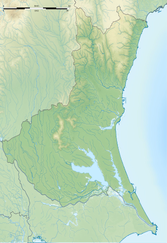
517:File:Ibaraki-ken géolocalisation.svg
490:Attribution and Share-Alike required
913:
634:
629:
370:(SRTM3 v.2) (domaine public) ;
1570:
752:
746:
646:Attribution-Share Alike 2.0 France
620:
616:
593:
535:
498:Wikimedia Commons user: Bourrichon
265:
264:
253:
241:
229:
217:
205:
189:
130:
80:
751:
195:Carte topographique vierge de la
887:coordinates of the point of view
737:
683:Under the following conditions:
641:This file is licensed under the
633:
628:
622:
587:
561:
528:
254:
203:, destinée à la géolocalisation.
166:
152:
97:
31:
21:
1155:Mawatari Haniwa Production Site
734:
404:Other symbols / autres symboles
242:
230:
218:
14:
733:
227:, for geolocalisation purpose.
206:
190:
26:
1:
416:Software / logiciels utilisés
294:Approximate geographic limits
223:Topographic blank map of the
36:
1095:Japan Golf Tour Championship
974:fr:Préfecture d'Ibaraki
576:. For more information see:
560:
487:
359:Création personnelle ;
322:Shaded relief / relief ombré
1403:Centrale nucléaire de Tōkai
1284:Usage on ceb.wikipedia.org
1175:Mito Tokugawa clan cemetery
902:36°0'0.000"N, 140°0'0.000"E
578:About translating SVG files
1617:
1374:Usage on fr.wikipedia.org
1359:Usage on fa.wikipedia.org
1344:Usage on es.wikipedia.org
1304:Usage on de.wikipedia.org
1294:Usage on ce.wikipedia.org
1274:Usage on ar.wikipedia.org
697:same or compatible license
567:
441:pour le relief de la NASA.
1220:The Championship by Lexus
1160:Minamishiio Choseichi Dam
914:
408:File:Maps template-fr.svg
211:Topographische Karte der
16:
736:
663:
247:Mappa topografica della
104:This is a file from the
1105:Kamitakatsu Shell Mound
971:
568:This SVG file contains
527:
512:
473:
452:
354:
346:
343:
235:Mapa topográfico de la
182:
108:. Information from its
1215:Seki Castle (Chikusei)
1055:Heiwa PGM Championship
1005:Atagoyama Kofun (Mito)
727:
172:36.000000; 140.000000
111:description page there
1085:Isohama Kofun Cluster
1020:Daiwatari Kanga ruins
1010:Chōjayama Kanga ruins
726:
280:Échelle approximative
249:Prefettura di Ibaraki
237:Prefectura de Ibaraki
1298:Ибараки (префектура)
1205:Okadaira Shell Mound
1185:Niihari temple ruins
1065:Hirohata Shell Mound
1060:Hirasawa Kanga ruins
197:Préfecture d'Ibaraki
74:1,720 × 2,502 pixels
70:1,408 × 2,048 pixels
1180:Niihari Gunga ruins
1090:Izumisakashita Site
1000:Adastria Mito Arena
678:– to adapt the work
544:(fr). You can
420:dans ce didacticiel
52:Other resolutions:
1443:Circuit de Tsukuba
1368:مدرسه میتو کودوکان
1245:Ōgushi Shell Mound
1070:Hitachi Kokubun-ji
1045:Funazukayama Kofun
995:Acom International
950:16:06, 8 July 2013
728:
608:
574:SVG Translate tool
348:3 July 2013, 18:49
304:* O : 139.67
302:* E : 140.95
225:Ibaraki Prefecture
66:704 × 1,024 pixels
1604:
1603:
1584:Generated with Qt
1562:more global usage
1448:Hitachi (Ibaraki)
1313:Kasumigaura (See)
1266:Global file usage
1240:Yūki temple ruins
1130:Konda Kanga ruins
1025:Fudoyatsu-ike Dam
983:
817:copyright license
745:
658:atelier graphique
601:was created with
585:
584:
583:
553:
552:
522:
521:
508:
507:
482:
479:Reusing this file
448:
444:
418:(méthode décrite
337:
315:
305:
298:* N : 36.98
296:of the map :
287:
284:Approximate scale
213:Präfektur Ibaraki
177:
176:
126:
125:
106:Wikimedia Commons
32:Global file usage
1608:
1578:
1543:Kasama (Ibaraki)
1230:Tsuchiura Castle
1115:Kawaratsuka Kiln
962:
781:copyright status
725:
719:
716:
713:
710:
707:
699:as the original.
661:
643:Creative Commons
637:
636:
632:
631:
626:
625:
591:
565:
558:
532:
525:
486:
476:
464:
447:
414:
349:
320:
310:
300:* S : 35.65
292:
278:
269:
258:
246:
234:
222:
210:
194:
192:Français :
186:
180:
173:
170:
156:
155:
149:
148:
137:
122:
101:
100:
94:
88:
77:
62:528 × 768 pixels
58:330 × 480 pixels
54:165 × 240 pixels
48:412 × 599 pixels
1616:
1615:
1611:
1610:
1609:
1607:
1606:
1605:
1566:
1508:Bandō (Ibaraki)
1493:Itako (Ibaraki)
1413:Lac Kasumigaura
1388:Tōkai (Ibaraki)
1264:
991:
984:
968:
960:
916:
915:
912:
911:
910:
909:
908:
907:
906:
905:
903:
893:
892:
891:
889:
878:
877:
876:
875:
874:
873:
872:
871:
869:
859:
858:
857:
855:
844:
843:
842:
841:
840:
839:
838:
837:
835:
823:
822:
821:
819:
808:
807:
806:
805:
804:
803:
802:
801:
799:
787:
786:
785:
783:
772:
771:
770:
769:
768:
766:
750:
749:
748:
731:
730:
729:
723:
720:
717:
714:
711:
709:CC BY-SA 2.0 fr
708:
705:
704:
662:
652:
649:
638:
619:
618:
613:
607:
606:
596:W3C-unspecified
549:
523:
462:
275:
263:
252:
240:
228:
216:
204:
184:
171:
144:
143:
140:Camera location
135:
128:
127:
116:
115:
114:is shown below.
90:
86:
79:
78:
51:
12:
11:
5:
1614:
1612:
1602:
1601:
1598:
1594:
1593:
1590:
1586:
1585:
1582:
1569:
1564:of this file.
1558:
1557:
1556:
1555:
1550:
1545:
1540:
1535:
1530:
1525:
1520:
1515:
1510:
1505:
1503:Naka (Ibaraki)
1500:
1495:
1490:
1485:
1480:
1475:
1470:
1465:
1460:
1455:
1450:
1445:
1440:
1435:
1430:
1425:
1420:
1415:
1410:
1405:
1400:
1395:
1390:
1385:
1380:
1372:
1371:
1370:
1365:
1357:
1356:
1355:
1350:
1342:
1341:
1340:
1335:
1330:
1328:Burg Tsuchiura
1325:
1320:
1315:
1310:
1308:Tsukuba (Berg)
1302:
1301:
1300:
1292:
1291:
1290:
1282:
1281:
1280:
1268:
1267:
1263:
1262:
1257:
1252:
1247:
1242:
1237:
1232:
1227:
1225:Torazuka Kofun
1222:
1217:
1212:
1207:
1202:
1197:
1192:
1187:
1182:
1177:
1172:
1167:
1165:Minowa-ike Dam
1162:
1157:
1152:
1147:
1142:
1140:Kōdōkan (Mito)
1137:
1132:
1127:
1122:
1117:
1112:
1107:
1102:
1097:
1092:
1087:
1082:
1077:
1075:Hitachi Kokufu
1072:
1067:
1062:
1057:
1052:
1047:
1042:
1040:Fukuroda Falls
1037:
1032:
1027:
1022:
1017:
1012:
1007:
1002:
997:
989:
988:
987:
982:
981:
970:
966:
963:
959:1,720 × 2,502
957:
952:
947:
943:
942:
939:
936:
933:
930:
927:
920:
919:
904:
901:
899:
898:
897:
896:
895:
894:
890:
885:
883:
882:
881:
880:
870:
867:
865:
864:
863:
862:
861:
860:
856:
851:
849:
848:
847:
846:
845:
836:
831:
829:
828:
827:
826:
825:
824:
820:
815:
813:
812:
811:
810:
809:
800:
795:
793:
792:
791:
790:
789:
788:
784:
779:
777:
776:
775:
774:
773:
767:
762:
760:
757:
756:
755:
754:
753:
742:
741:
738:
735:
721:
703:
702:
701:
700:
690:
681:
680:
679:
673:
666:You are free:
650:
640:
639:
621:
615:
614:
612:
609:
586:
582:
581:
566:
551:
550:
546:propose images
533:
520:
519:
514:
513:Other versions
510:
509:
506:
505:
493:
492:
483:
471:
470:
454:
450:
449:
446:
445:
443:
442:
435:
429:
411:
410:
400:
399:
384:
383:
372:
371:
356:
352:
351:
345:
341:
340:
339:
338:
328:est une image
317:
316:
307:
306:
289:
288:
187:
178:
175:
174:
164:
158:
141:
134:
131:
129:
124:
123:
102:
92:
91:
45:
41:
40:
39:
34:
29:
24:
19:
13:
10:
9:
6:
4:
3:
2:
1613:
1599:
1596:
1591:
1588:
1583:
1580:
1576:
1573:
1567:
1565:
1563:
1554:
1551:
1549:
1546:
1544:
1541:
1539:
1536:
1534:
1531:
1529:
1526:
1524:
1521:
1519:
1516:
1514:
1511:
1509:
1506:
1504:
1501:
1499:
1496:
1494:
1491:
1489:
1486:
1484:
1481:
1479:
1476:
1474:
1471:
1469:
1466:
1464:
1461:
1459:
1456:
1454:
1451:
1449:
1446:
1444:
1441:
1439:
1436:
1434:
1431:
1429:
1426:
1424:
1421:
1419:
1416:
1414:
1411:
1409:
1406:
1404:
1401:
1399:
1396:
1394:
1391:
1389:
1386:
1384:
1381:
1379:
1376:
1375:
1373:
1369:
1366:
1364:
1361:
1360:
1358:
1354:
1351:
1349:
1348:Monte Tsukuba
1346:
1345:
1343:
1339:
1336:
1334:
1331:
1329:
1326:
1324:
1321:
1319:
1316:
1314:
1311:
1309:
1306:
1305:
1303:
1299:
1296:
1295:
1293:
1289:
1286:
1285:
1283:
1279:
1276:
1275:
1273:
1272:
1271:
1265:
1261:
1258:
1256:
1253:
1251:
1248:
1246:
1243:
1241:
1238:
1236:
1235:Yoshida Kofun
1233:
1231:
1228:
1226:
1223:
1221:
1218:
1216:
1213:
1211:
1208:
1206:
1203:
1201:
1198:
1196:
1193:
1191:
1188:
1186:
1183:
1181:
1178:
1176:
1173:
1171:
1168:
1166:
1163:
1161:
1158:
1156:
1153:
1151:
1150:Makabe Castle
1148:
1146:
1143:
1141:
1138:
1136:
1133:
1131:
1128:
1126:
1123:
1121:
1118:
1116:
1113:
1111:
1110:Kasama Castle
1108:
1106:
1103:
1101:
1098:
1096:
1093:
1091:
1088:
1086:
1083:
1081:
1078:
1076:
1073:
1071:
1068:
1066:
1063:
1061:
1058:
1056:
1053:
1051:
1050:Gozenyama Dam
1048:
1046:
1043:
1041:
1038:
1036:
1033:
1031:
1030:Fujiigawa Dam
1028:
1026:
1023:
1021:
1018:
1016:
1013:
1011:
1008:
1006:
1003:
1001:
998:
996:
993:
985:
979:
975:
969:
964:
958:
956:
953:
951:
948:
945:
944:
940:
937:
934:
931:
928:
926:
925:
923:
917:
888:
854:
834:
818:
798:
782:
765:
698:
694:
691:
688:
685:
684:
682:
677:
674:
671:
668:
667:
665:
664:
659:
655:
651:Attribution:
647:
644:
627:
610:
604:
600:
597:
590:
579:
575:
571:
564:
559:
556:
555:
547:
543:
539:
538:Wikigraphists
534:
531:
526:
518:
515:
511:
503:
499:
495:
491:
488:
484:
480:
475:
472:
469:
468:fr:Bourrichon
465:
459:
455:
451:
440:
439:Global Mapper
436:
433:
430:
427:
424:
423:
421:
417:
413:
412:
409:
406:provenant de
405:
402:
401:
397:
393:
392:Openstreetmap
389:
386:
385:
381:
377:
374:
373:
369:
365:
362:
361:
360:
357:
353:
342:
335:
334:shaded relief
331:
327:
323:
319:
318:
313:
309:
308:
303:
301:
299:
297:
295:
291:
290:
285:
281:
277:
276:
273:
268:
261:
257:
250:
245:
238:
233:
226:
221:
214:
209:
202:
198:
193:
188:
181:
169:
165:
163:
162:OpenStreetMap
159:
157:
147:
142:
138:
132:
120:
113:
112:
107:
103:
96:
95:
89:
84:
83:Original file
75:
71:
67:
63:
59:
55:
49:
44:
38:
35:
33:
30:
28:
25:
23:
20:
18:
15:
1574:
1571:
1559:
1548:Tsukubamirai
1418:Mont Tsukuba
1383:Hitachiōmiya
1269:
1135:Kozogawa Dam
1015:Daihō Castle
921:
918:File history
692:
686:
675:
669:
599:vector image
595:
569:
554:
489:
415:
403:
396:thinkgeo.com
387:
375:
363:
358:
333:
329:
326:relief ombré
325:
321:
311:
293:
283:
279:
266:
255:
243:
231:
219:
207:
191:
119:You can help
109:
81:
22:File history
1581:Image title
1518:Kasumigaura
1478:Kitaibaraki
1423:Hitachinaka
1338:Burg Kasama
1170:Mito Castle
1125:Koga Castle
1035:Fukuoka Dam
868:3 July 2013
797:copyrighted
693:share alike
687:attribution
542:Graphic Lab
426:Quantum GIS
376:Bathymétrie
364:Topographie
267:Português:
183:Description
1533:Sakuragawa
1468:Hitachiōta
1428:Shimotsuma
1200:Oda Castle
1190:Nikkei Cup
1145:Lake Senba
1120:Kirin Open
1100:Kairaku-en
986:File usage
967:Bourrichon
935:Dimensions
654:Bourrichon
474:Permission
458:Bourrichon
312:Projection
244:Italiano:
27:File usage
1458:Ryūgasaki
1433:Tsuchiura
1333:Burg Koga
1318:Burg Mito
961:(2.78 MB)
932:Thumbnail
929:Date/Time
853:inception
611:Licensing
422:) :
232:Español:
220:English:
208:Deutsch:
1568:Metadata
1528:Namegata
1513:Inashiki
1473:Takahagi
1393:Chikusei
1210:Seizansō
1080:Iida Dam
740:Captions
676:to remix
670:to share
648:license.
603:Inkscape
432:Inkscape
378: :
366: :
37:Metadata
1553:Omitama
1438:Kashima
1408:Ishioka
1398:Tsukuba
946:current
941:Comment
764:depicts
744:English
540:of the
502:message
434: ;
428: ;
398: ;
272:Ibaraki
133:Summary
85:
1597:Height
1538:Hokota
1523:Kamisu
1498:Moriya
1488:Ushiku
1483:Toride
592:
453:Author
380:ETOPO1
355:Source
330:bitmap
150:
1589:Width
1560:View
978:Japon
976:, au
594:This
350:(UTC)
201:Japon
199:, au
1600:2502
1592:1720
1463:Jōsō
1453:Yūki
1378:Mito
938:User
718:true
715:true
466:) -
463:talk
394:via
344:Date
262:の地図.
256:日本語:
17:File
260:茨城県
580:.
456:©
72:|
68:|
64:|
60:|
56:|
50:.
660:)
656:(
605:.
481:)
477:(
460:(
437:+
274:.
251:.
239:.
215:.
121:.
76:.
Text is available under the Creative Commons Attribution-ShareAlike License. Additional terms may apply.
