155:
170:
404:
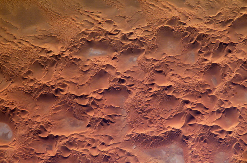
types suggests that wind regimes have changed through time. The active nature of this portion of the Erg is well illustrated by this image—smaller dunes form and migrate along the flanks of the larger dunes and sand ridges. Occasional precipitation fills basins formed by the dunes; as the water evaporates, salt deposits are left behind which appear as bluish-white areas.
490:
91:
43:
1078:
1008:
403:
The most common landforms in the image are star dunes and barchan (or crescent) dunes. Small linear dunes appear at top left. Star dunes are formed when sand is transported from variable wind directions, whereas barchan dunes form in a single dominant wind regime. The superimposition of two dune
400:
The
Issaouane Erg (sand sea) is located in eastern Algeria between the Tinrhert Plateau to the north and the Fadnoun Plateau to the south. Ergs are vast areas of moving sand with little to no vegetation cover. Considered to be part of the Sahara Desert, the Issaouane Erg covers an area of
774:
791:==Summary== {{Information | Description=Astronaut photo of the Issaouane Erg (Sahara Desert), Algeria. | Source=http://earthobservatory.nasa.gov/Newsroom/NewImages/images.php3?img_id=16813 | Date=January 16, 2005 | Author=ISS Crew Earth Observations exper
195:
988:
57:
53:
47:
102:
70:
1018:
1088:
446:
1108:
719:
1186:
This file contains additional information, probably added from the digital camera or scanner used to create or digitize it.
522:
161:
1083:
703:
669:
635:
618:
254:
427:
577:
1189:
If the file has been modified from its original state, some details may not fully reflect the modified file.
1138:
828:
833:
773:
768:
61:
42:
978:
437:
ISS Crew Earth
Observations experiment and the Image Science & Analysis Group, Johnson Space Center.
377:
507:
Johnson Space Center. NASA copyright policy states that "NASA material is not protected by copyright
359:
503:
in the United States because it was created by the Image
Science & Analysis Laboratory, of the
401:
approximately 38,000 km2. These complex dunes form the active southwestern border of the sand sea.
110:
784:
293:
512:
187:
805:
499:
810:
97:
239:
1073:
953:
863:
853:
843:
572:
417:
568:
564:
560:
556:
552:
548:
544:
540:
536:
532:
229:
428:
http://earthobservatory.nasa.gov/Newsroom/NewImages/images.php3?img_id=16813
306:
1098:
741:
Click on a date/time to view the file as it appeared at that time.
883:
504:
1053:
516:
933:
484:
145:
Astronaut photo of the
Issaouane Erg (Sahara Desert), Algeria.
85:
998:
903:
893:
169:
154:
1163:
1118:
1038:
979:
Scienze della Terra per le superiori/Il modellamento eolico
1028:
1148:
1079:Портал:География/Избранное изображение/Текущая подборка
1063:
602:
Add a one-line explanation of what this file represents
913:
1173:
968:
129:
109:
Commons is a freely licensed media file repository.
75:(1,000 × 662 pixels, file size: 491 KB, MIME type:
923:
1128:
1048:
963:
943:
1153:
873:
1009:Портал:Географий/Ойырымо сӱрет/Кызытсе ойырымаш
90:
8:
325:
1191:
743:
598:
576:
517:Conditions of Use of Astronaut Photographs
464:
821:The following other wikis use this file:
1193:
803:
717:
701:
683:
667:
649:
633:
616:
613:
594:
587:
135:IssaouaneErg Algeria ISS010-E-13539.jpg
275:Kodak DCS760C Electronic Still Camera
150:
801:The following 2 pages use this file:
489:
7:
732:
283:3060 x 2036 pixel CCD, RGBG array.
1184:
607:
601:
495:
318:
139:
122:
68:
606:
372:188 nautical miles (348 km)
592:
488:
351:Nadir to Photo Center Direction
168:
153:
89:
31:
21:
589:
224:ISSAOUANE SAND SEA, STAR DUNES
140:
14:
588:
26:
1:
160:ISS Crew Earth Observations:
36:
614:Items portrayed in this file
1125:Usage on sv.wiktionary.org
1045:Usage on pl.wiktionary.org
1005:Usage on mhr.wikipedia.org
940:Usage on fr.wiktionary.org
880:Usage on ceb.wikipedia.org
213:Country or Geographic Name
1215:
1170:Usage on www.wikidata.org
1160:Usage on vi.wikipedia.org
1145:Usage on uz.wikipedia.org
1135:Usage on uk.wikipedia.org
1115:Usage on sv.wikipedia.org
1105:Usage on sr.wikipedia.org
1095:Usage on sl.wikipedia.org
1070:Usage on ru.wikipedia.org
1060:Usage on ro.wikipedia.org
1035:Usage on pl.wikipedia.org
1025:Usage on nn.wikipedia.org
1015:Usage on mk.wikipedia.org
995:Usage on lt.wikipedia.org
985:Usage on ka.wikipedia.org
975:Usage on it.wikibooks.org
960:Usage on it.wikipedia.org
950:Usage on hi.wikipedia.org
930:Usage on fr.wikipedia.org
920:Usage on fi.wikipedia.org
910:Usage on eo.wikipedia.org
900:Usage on de.wikipedia.org
890:Usage on da.wikipedia.org
870:Usage on br.wikipedia.org
860:Usage on bg.wikipedia.org
850:Usage on be.wikipedia.org
840:Usage on ba.wikipedia.org
825:Usage on ar.wikipedia.org
733:
513:NASA media use guidelines
399:
394:
302:
294:Percentage of Cloud Cover
287:
248:
182:
177:
16:
591:
96:This is a file from the
1089:Участник:Alogrin/Сахара
790:
441:
433:
423:
416:
413:
395:Original image caption
132:
100:. Information from its
343:Nadir Point Longitude
240:Center Point Longitude
103:description page there
46:Size of this preview:
1019:Ерг (земјиштен облик)
335:Nadir Point Latitude
230:Center Point Latitude
884:Isaouane-n-Irarraren
497:This file is in the
369:Spacecraft Altitude
264:Camera Focal Length
453:NASA, public domain
378:Sun Elevation Angle
174:
52:Other resolutions:
769:17:58, 18 May 2006
151:
62:1,000 × 662 pixels
1202:
1201:
817:Global file usage
794:
600:
586:
585:
580:
483:
482:
457:
456:
450:
447:Reusing this file
409:
408:
309:
118:
117:
98:Wikimedia Commons
32:Global file usage
1206:
1192:
999:Ergas (reljefas)
989:ერგი (გეოგრაფია)
781:
581:
492:
491:
485:
479:
476:
473:
470:
465:
444:
419:
379:
361:
327:
320:
310:
305:
295:
256:
241:
231:
197:
175:
173:
172:
171:
166:
158:
157:
156:
144:
136:
130:
114:
93:
92:
86:
80:
78:
65:
58:640 × 424 pixels
54:320 × 212 pixels
48:800 × 530 pixels
1214:
1213:
1209:
1208:
1207:
1205:
1204:
1203:
1180:
1109:Пешчана пустиња
1084:Эрг (география)
815:
795:
787:
779:
735:
734:
731:
730:
729:
728:
727:
726:
725:
724:
722:
710:
709:
708:
706:
695:
694:
693:
692:
691:
690:
689:
688:
686:
676:
675:
674:
672:
661:
660:
659:
658:
657:
656:
655:
654:
652:
651:16 January 2005
642:
641:
640:
638:
627:
626:
625:
624:
623:
621:
605:
604:
603:
531:
528:
477:
474:
471:
468:
463:
458:
418:16 January 2005
304:
178:Identification
167:
159:
152:
146:
134:
127:
120:
119:
108:
107:
106:is shown below.
82:
76:
74:
67:
66:
51:
12:
11:
5:
1212:
1210:
1200:
1199:
1196:
1183:
1179:
1178:
1177:
1176:
1168:
1167:
1166:
1158:
1157:
1156:
1151:
1143:
1142:
1141:
1133:
1132:
1131:
1123:
1122:
1121:
1119:Erg (landform)
1113:
1112:
1111:
1103:
1102:
1101:
1093:
1092:
1091:
1086:
1081:
1076:
1068:
1067:
1066:
1058:
1057:
1056:
1051:
1043:
1042:
1041:
1039:Erg (pustynia)
1033:
1032:
1031:
1023:
1022:
1021:
1013:
1012:
1011:
1003:
1002:
1001:
993:
992:
991:
983:
982:
981:
973:
972:
971:
966:
958:
957:
956:
948:
947:
946:
938:
937:
936:
928:
927:
926:
918:
917:
916:
908:
907:
906:
898:
897:
896:
888:
887:
886:
878:
877:
876:
868:
867:
866:
858:
857:
856:
848:
847:
846:
838:
837:
836:
831:
819:
818:
814:
813:
808:
806:Erg (landform)
799:
798:
793:
792:
789:
785:
782:
776:
771:
766:
762:
761:
758:
755:
752:
749:
746:
739:
738:
723:
718:
716:
715:
714:
713:
712:
711:
707:
702:
700:
699:
698:
697:
696:
687:
684:
682:
681:
680:
679:
678:
677:
673:
668:
666:
665:
664:
663:
662:
653:
650:
648:
647:
646:
645:
644:
643:
639:
634:
632:
631:
630:
629:
628:
622:
617:
615:
612:
611:
610:
609:
608:
597:
596:
593:
590:
584:
583:
523:ISS010-E-13539
521:Photo source:
493:
481:
480:
462:
459:
455:
454:
451:
439:
438:
435:
431:
430:
425:
421:
420:
415:
411:
410:
407:
406:
397:
396:
392:
391:
388:
384:
383:
380:
374:
373:
370:
366:
365:
362:
356:
355:
352:
348:
347:
344:
340:
339:
336:
332:
331:
328:
322:
321:
316:
312:
311:
307:What is Nadir?
300:
299:
296:
290:
289:
285:
284:
281:
277:
276:
273:
269:
268:
265:
261:
260:
257:
251:
250:
246:
245:
242:
236:
235:
232:
226:
225:
222:
218:
217:
214:
210:
209:
206:
202:
201:
198:
192:
191:
184:
180:
179:
163:ISS010-E-13539
137:
128:
126:
123:
121:
116:
115:
94:
84:
83:
45:
41:
40:
39:
34:
29:
24:
19:
13:
10:
9:
6:
4:
3:
2:
1211:
1197:
1194:
1190:
1187:
1181:
1175:
1172:
1171:
1169:
1165:
1162:
1161:
1159:
1155:
1152:
1150:
1147:
1146:
1144:
1140:
1139:Ерг (пустеля)
1137:
1136:
1134:
1130:
1127:
1126:
1124:
1120:
1117:
1116:
1114:
1110:
1107:
1106:
1104:
1100:
1099:Peščeno morje
1097:
1096:
1094:
1090:
1087:
1085:
1082:
1080:
1077:
1075:
1072:
1071:
1069:
1065:
1062:
1061:
1059:
1055:
1052:
1050:
1047:
1046:
1044:
1040:
1037:
1036:
1034:
1030:
1029:Landforma erg
1027:
1026:
1024:
1020:
1017:
1016:
1014:
1010:
1007:
1006:
1004:
1000:
997:
996:
994:
990:
987:
986:
984:
980:
977:
976:
974:
970:
967:
965:
962:
961:
959:
955:
952:
951:
949:
945:
942:
941:
939:
935:
932:
931:
929:
925:
922:
921:
919:
915:
912:
911:
909:
905:
902:
901:
899:
895:
892:
891:
889:
885:
882:
881:
879:
875:
872:
871:
869:
865:
862:
861:
859:
855:
852:
851:
849:
845:
842:
841:
839:
835:
832:
830:
829:عرق (جغرافيا)
827:
826:
824:
823:
822:
816:
812:
811:Issaouane Erg
809:
807:
804:
802:
796:
788:
783:
777:
775:
772:
770:
767:
764:
763:
759:
756:
753:
750:
747:
745:
744:
742:
736:
721:
720:Kodak DCS 760
705:
704:captured with
671:
637:
620:
582:
579:
574:
570:
566:
562:
558:
554:
550:
546:
542:
538:
534:
529:
527:
524:
520:
518:
514:
510:
506:
502:
501:
500:public domain
494:
487:
486:
472:Public domain
469:Public domain
467:
466:
460:
452:
448:
443:
440:
436:
432:
429:
426:
422:
412:
405:
398:
393:
389:
387:Orbit Number
386:
385:
381:
376:
375:
371:
368:
367:
363:
358:
357:
353:
350:
349:
345:
342:
341:
337:
334:
333:
329:
324:
323:
317:
314:
313:
308:
301:
297:
292:
291:
286:
282:
279:
278:
274:
271:
270:
266:
263:
262:
259:High Oblique
258:
253:
252:
247:
243:
238:
237:
233:
228:
227:
223:
220:
219:
215:
212:
211:
207:
204:
203:
199:
194:
193:
189:
188:Expedition 10
185:
181:
176:
165:
164:
149:
148:
143:
138:
131:
124:
112:
105:
104:
99:
95:
88:
87:
81:
72:
71:Original file
63:
59:
55:
49:
44:
38:
35:
33:
30:
28:
25:
23:
20:
18:
15:
1188:
1185:
1149:Sahroi Kabir
934:Erg (désert)
820:
800:
778:1,000 × 662
740:
737:File history
530:
525:
509:unless noted
508:
498:
496:
402:
267:800 mm
162:
147:
141:
111:You can help
101:
69:
22:File history
904:Erg (Wüste)
894:Erg (ørken)
834:عرق إيساوان
786:Holly Cheng
360:Sun Azimuth
255:Camera Tilt
133:Description
1195:_error
1064:Erg (dune)
797:File usage
754:Dimensions
685:image/jpeg
670:media type
561:македонски
442:Permission
354:Southwest
319:2005-01-16
77:image/jpeg
27:File usage
914:Sablomaro
751:Thumbnail
748:Date/Time
636:inception
573:sicilianu
569:português
533:العربيَّة
461:Licensing
330:14:25:12
221:Features
142:English:
1182:Metadata
1174:Q6088083
780:(491 KB)
595:Captions
575: |
571: |
567: |
563: |
559: |
555: |
553:italiano
551: |
549:français
547: |
543: |
539: |
535: |
346:19.4° E
338:36.7° N
288:Quality
234:26.8° N
216:ALGERIA
186:ISS010 (
183:Mission
37:Metadata
969:Algeria
765:current
760:Comment
619:depicts
599:English
545:español
541:English
537:Deutsch
272:Camera
249:Camera
244:7.3° E
125:Summary
73:
1164:Sa mạc
1074:Сахара
864:Сахара
854:Сахара
844:Сахара
565:മലയാളം
434:Author
424:Source
303:Nadir
298:0-10%
208:13539
205:Frame
924:Dyyni
557:kurdî
478:false
475:false
390:3185
364:230°
315:Date
280:Film
964:Duna
954:अर्ग
757:User
511:". (
505:NASA
414:Date
382:14°
326:Time
196:Roll
17:File
1154:Erg
1129:erg
1054:ерг
1049:erg
944:erg
874:Erg
578:+/−
515:or
519:).
200:E
190:)
60:|
56:|
50:.
1198:0
526:.
449:)
445:(
113:.
79:)
64:.
Text is available under the Creative Commons Attribution-ShareAlike License. Additional terms may apply.