43:
287:
542:
458:
499:
450:
472:
548:
1415:
403:
553:
365:
99:
354:
1147:
1177:
1114:
441:
1465:
1405:
611:– You must give appropriate credit, provide a link to the license, and indicate if changes were made. You may do so in any reasonable manner, but not in any way that suggests the licensor endorses you or your use.
1395:
1327:
1679:
1322:
1332:
418:
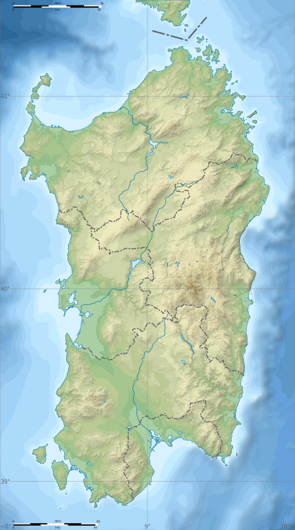
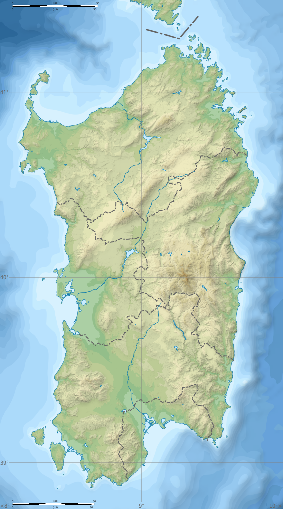
172:, Italie, destinée à la géolocalisation, avec les limites des provinces. Niveaux d'altitudes : 25 m, 50, 100, 200, 400, 600, etc. Idem pour la bathymétrie.
69:
73:
65:
61:
57:
53:
47:
1342:
1217:
110:
1212:
1198:, Italy, for geo-location purpose, with province boundaries. Altitude levels : 25m, 50, 100, 200, 400, 600, etc. (same for bathymetry)}} {{fr|Carte topo
82:
1337:
159:, Italy, for geo-location purpose, with province boundaries. Altitude levels : 25m, 50, 100, 200, 400, 600, etc. (same for bathymetry).
1292:
253:
1347:
1317:
1176:
1171:
1146:
1141:
969:
933:
916:
899:
882:
865:
812:
465:
278:
1232:
1227:
1222:
1690:
This file contains additional information, probably added from the digital camera or scanner used to create or digitize it.
848:
1131:
618:
762:
1050:
1023:
953:
796:
770:
755:
740:
725:
989:
832:
698:
681:
286:
414:
747:
580:
576:
572:
568:
564:
410:
1693:
If the file has been modified from its original state, some details may not fully reflect the modified file.
1312:
1208:
The following pages on the
English Knowledge (XXG) use this file (pages on other projects are not listed):
381:
1113:
1108:
617:– If you remix, transform, or build upon the material, you must distribute your contributions under the
42:
504:
Copyleft: This work of art is free; you can redistribute it and/or modify it according to terms of the
1440:
1375:
1252:
560:
506:
1365:
1287:
1247:
732:
118:
249:
1435:
1307:
1297:
1242:
304:
242:
Topography : NASA Shuttle Radar
Topography Mission (SRTM3 v.2) (public domain) ;
1302:
1187:
471:
374:
320:
1262:
490:
I, the copyright holder of this work, hereby publish it under the following licenses:
402:
239:
Shorelines : NASA Shuttle Radar
Topography Mission (SWBD) (public domain) ;
221:
105:
1455:
1425:
1157:
1124:
1445:
1565:
1277:
1272:
1267:
1257:
266:
1650:
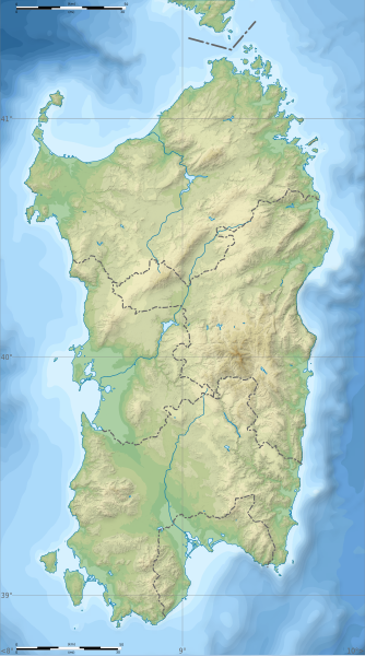
1194:== {{int:filedesc}} == {{Information |Description= {{en|Blank physical map of
515:
493:
1282:
156:
1560:
378:
169:
1480:
1195:
1237:
338:
315:
511:
455:
324:
1645:
1081:
Click on a date/time to view the file as it appeared at that time.
1328:
User:Noclador/sandbox/Royal
Italian Army - Italy - September 1943
1585:
1485:
457:
364:
432:
93:
1555:
353:
87:(SVG file, nominally 601 × 1,078 pixels, file size: 1.62 MB)
1605:
1595:
1500:
1385:
900:
Creative
Commons Attribution-ShareAlike 4.0 International
442:
40° 07′ 30″ N, 9° 00′ 00″ E
1665:
1600:
1590:
1575:
1505:
1625:
1510:
665:
Add a one-line explanation of what this file represents
1660:
1655:
1635:
1615:
1540:
1520:
1670:
1640:
1630:
1620:
1550:
1535:
1530:
1475:
1580:
1570:
1495:
917:
Creative
Commons Attribution-ShareAlike 3.0 Unported
137:
117:
Commons is a freely licensed media file repository.
1545:
1525:
934:
Creative
Commons Attribution-ShareAlike 2.0 Generic
883:
Creative
Commons Attribution-ShareAlike 1.0 Generic
866:
Creative
Commons Attribution-ShareAlike 2.5 Generic
421:to clean up, improve, create or translate as well.
1610:
1323:User:Michael!/Project:Location map templates/Italy
510:. You will find a specimen of this license on the
1333:Template:Sardinia regional languages labelled map
733:https://commons.wikimedia.org/user:S%C3%A9mhur
628:https://creativecommons.org/licenses/by-sa/4.0
245:Bathymetry: NGDC ETOPO1 (public domain) ;
98:
1213:184th Paratroopers Division "Nembo"
634:Creative Commons Attribution-Share Alike 4.0
541:
8:
1218:2019 European Ladies' Team Championship
1416:টেমপ্লেট:অবস্থান মানচিত্র ইতালি সার্দিনিয়া
1343:Module:Location map/data/Italy Sardinia/doc
594:– to copy, distribute and transmit the work
46:Size of this PNG preview of this SVG file:
1695:
1441:Mòdul:Location map/data/Itàlia Sardenya/ús
1083:
661:
646:You may select the license of your choice.
397:
1358:The following other wikis use this file:
498:
409:This map was improved or created by the
1705:
1697:
1436:Mòdul:Location map/data/Itàlia Sardenya
1338:Module:Location map/data/Italy Sardinia
1210:
1037:
1021:
1003:
987:
967:
951:
931:
914:
897:
880:
863:
846:
830:
810:
794:
712:
696:
679:
676:
657:
650:
435:
282:
177:Equirectangular projection, WGS84 datum
1293:Mechanized Brigade "Sassari"
464:View this and other nearby images on:
143:Italy Sardinia relief location map.svg
1456:Plantilya:Location map Italy Sardinia
1376:Şablon:Yer xəritəsi İtaliya Sardiniya
277:Derivative works of this file:
7:
1072:
552:
547:
256:under licence cc-by-sa-3.0 or GFDL.
1688:
1566:Modul:Location map data it-88/Doku
670:
664:
645:
538:
520:http://artlibre.org/licence/lal/en
489:
408:
369:
358:
161:
148:
130:
80:
1651:Santuario nuragico Santa Cristina
1426:Šablon:Lokacijska karta Sardinija
1348:Module:Location map/data/Sardinia
1132:c:User:Rillke/bigChunkedUpload.js
669:
168:Carte topographique vierge de la
1466:Кеп:Меттиган карта Итали Сардини
1446:Mòdul:Location map/data/Sardenya
1406:Шаблон:На карце/Італія Сардзінія
1366:قالب:Location map Italy Sardinia
1318:User:Broc/sandbox/Capo Malfatano
1024:coordinates of the point of view
677:Éléments décrits dans ce fichier
655:
605:Under the following conditions:
559:This file is licensed under the
551:
546:
540:
497:
470:
456:
448:
401:
363:
352:
285:
279:Aree protette della Sardegna.svg
97:
31:
21:
714:Valeur sans élément de Wikidata
652:
14:
1396:Ҡалып:ПозКарта Италия Сардиния
1233:205th Coastal Division (Italy)
1228:204th Coastal Division (Italy)
1223:203rd Coastal Division (Italy)
1164:New province boundaries (2016)
651:
186:True scale parallel: 40° 7' 30
26:
1:
1561:Modul:Location map data it-88
970:original creation by uploader
292:Equivalent administrative map
194:Geographic limits of the map:
182:Standard meridian: 009° 00' E
36:
1517:Usage on de.wikivoyage.org
1452:Usage on ceb.wikipedia.org
1382:Usage on bar.wikipedia.org
756:value of statement has role
248:Province boundaries :
1727:
1492:Usage on de.wikipedia.org
1472:Usage on cs.wikipedia.org
1462:Usage on ce.wikipedia.org
1432:Usage on ca.wikipedia.org
1422:Usage on bs.wikipedia.org
1412:Usage on bn.wikipedia.org
1402:Usage on be.wikipedia.org
1392:Usage on ba.wikipedia.org
1372:Usage on az.wikipedia.org
1362:Usage on ar.wikipedia.org
619:same or compatible license
447:
1073:
359:W3C-validity not checked.
233:
162:
149:
16:
654:
585:
563:Attribution-Share Alike
104:This is a file from the
1481:Šablona:LocMap Sardinie
1193:
1163:
1142:09:29, 25 February 2018
1130:
400:
305:required by the license
272:
262:
228:
220:
217:
140:
108:. Information from its
1313:Santo Stefano (island)
1172:15:29, 24 January 2010
512:Copyleft Attitude site
476:40.125000; 9.000000
222:24 January 2010, 15:29
155:Blank physical map of
111:description page there
1646:San Giovanni di Sinis
337:© Sémhur /
314:© Sémhur /
250:File:Sardinia Map.png
1253:Is Molas Senior Open
70:1,142 × 2,048 pixels
1486:San Pietro (ostrov)
1109:15:26, 4 March 2018
600:– to adapt the work
417:(fr). You can
52:Other resolutions:
1586:Posada (Sardinien)
1288:Languages of Italy
1248:Is Molas Challenge
771:author name string
741:Wikimedia username
74:601 × 1,078 pixels
66:571 × 1,024 pixels
1714:
1713:
1680:more global usage
1354:Global file usage
1308:San Pietro Island
1201:
833:copyright license
663:
565:4.0 International
537:
536:
481:
480:
430:
429:
426:
425:
391:Atelier graphique
377:was created with
339:Wikimedia Commons
316:Wikimedia Commons
308:
126:
125:
106:Wikimedia Commons
32:Global file usage
1718:
1696:
1298:Punta La Marmora
1243:Gulf of Oristano
1184:
1154:
1121:
1061:
1060:
1055:
849:Free Art License
797:copyright status
778:
775:
765:
760:
750:
745:
735:
730:
641:
638:
635:
632:
629:
621:as the original.
561:Creative Commons
555:
554:
550:
549:
544:
543:
533:
530:
527:
526:Free Art License
524:
521:
507:Free Art License
501:
500:
494:
477:
474:
460:
459:
453:
452:
451:
445:
444:
433:
405:
398:
367:
356:
325:Free Art License
302:
289:
235:
223:
211:South: 38° 45' N
207:North: 41° 30' N
203:East: 010° 00' E
199:West: 008° 00' E
167:
154:
144:
138:
122:
101:
100:
94:
88:
77:
62:428 × 768 pixels
58:267 × 480 pixels
54:134 × 240 pixels
48:334 × 599 pixels
1726:
1725:
1721:
1720:
1719:
1717:
1716:
1715:
1684:
1556:Sinis-Halbinsel
1352:
1209:
1202:
1190:
1182:
1160:
1152:
1127:
1119:
1075:
1074:
1071:
1070:
1069:
1068:
1067:
1066:
1065:
1064:
1063:
1062:
1058:
1056:
1053:
1044:
1043:
1042:
1040:
1030:
1029:
1028:
1026:
1015:
1014:
1013:
1012:
1011:
1010:
1009:
1008:
1006:
1005:24 January 2010
996:
995:
994:
992:
981:
980:
979:
978:
977:
976:
975:
974:
972:
960:
959:
958:
956:
945:
944:
943:
942:
941:
940:
939:
938:
936:
925:
924:
923:
922:
921:
919:
908:
907:
906:
905:
904:
902:
891:
890:
889:
888:
887:
885:
874:
873:
872:
871:
870:
868:
857:
856:
855:
854:
853:
851:
839:
838:
837:
835:
824:
823:
822:
821:
820:
819:
818:
817:
815:
803:
802:
801:
799:
788:
787:
786:
785:
784:
783:
782:
781:
780:
779:
776:
773:
767:
766:
761:
758:
752:
751:
746:
743:
737:
736:
731:
728:
719:
718:
717:
715:
705:
704:
703:
701:
690:
689:
688:
687:
686:
684:
668:
667:
666:
649:
648:
647:
643:
642:
639:
636:
633:
630:
627:
626:
584:
556:
531:
528:
525:
522:
519:
492:
491:
486:
475:
449:
440:
439:
436:Camera location
431:
422:
394:
386:
385:
372:W3C-unspecified
361:
360:
348:
334:
327:
311:
293:
290:
174:
173:
165:
160:
152:
142:
135:
128:
127:
116:
115:
114:is shown below.
90:
86:
79:
78:
51:
12:
11:
5:
1724:
1722:
1712:
1711:
1708:
1704:
1703:
1700:
1687:
1682:of this file.
1676:
1675:
1674:
1673:
1668:
1663:
1658:
1653:
1648:
1643:
1638:
1633:
1628:
1623:
1618:
1613:
1608:
1603:
1598:
1593:
1588:
1583:
1578:
1573:
1568:
1563:
1558:
1553:
1548:
1543:
1538:
1533:
1528:
1523:
1515:
1514:
1513:
1508:
1503:
1498:
1490:
1489:
1488:
1483:
1478:
1470:
1469:
1468:
1460:
1459:
1458:
1450:
1449:
1448:
1443:
1438:
1430:
1429:
1428:
1420:
1419:
1418:
1410:
1409:
1408:
1400:
1399:
1398:
1390:
1389:
1388:
1380:
1379:
1378:
1370:
1369:
1368:
1356:
1355:
1351:
1350:
1345:
1340:
1335:
1330:
1325:
1320:
1315:
1310:
1305:
1303:Punta Sardegna
1300:
1295:
1290:
1285:
1280:
1275:
1270:
1265:
1260:
1255:
1250:
1245:
1240:
1235:
1230:
1225:
1220:
1215:
1207:
1206:
1205:
1200:
1199:
1192:
1188:
1185:
1179:
1174:
1169:
1166:
1165:
1162:
1158:
1155:
1149:
1144:
1139:
1136:
1135:
1129:
1125:
1122:
1116:
1111:
1106:
1102:
1101:
1098:
1095:
1092:
1089:
1086:
1079:
1078:
1049:
1048:
1047:
1046:
1045:
1041:
1038:
1036:
1035:
1034:
1033:
1032:
1031:
1027:
1022:
1020:
1019:
1018:
1017:
1016:
1007:
1004:
1002:
1001:
1000:
999:
998:
997:
993:
988:
986:
985:
984:
983:
982:
973:
968:
966:
965:
964:
963:
962:
961:
957:
954:source of file
952:
950:
949:
948:
947:
946:
937:
932:
930:
929:
928:
927:
926:
920:
915:
913:
912:
911:
910:
909:
903:
898:
896:
895:
894:
893:
892:
886:
881:
879:
878:
877:
876:
875:
869:
864:
862:
861:
860:
859:
858:
852:
847:
845:
844:
843:
842:
841:
840:
836:
831:
829:
828:
827:
826:
825:
816:
811:
809:
808:
807:
806:
805:
804:
800:
795:
793:
792:
791:
790:
789:
769:
768:
754:
753:
739:
738:
724:
723:
722:
721:
720:
716:
713:
711:
710:
709:
708:
707:
706:
702:
697:
695:
694:
693:
692:
691:
685:
680:
678:
675:
674:
673:
672:
671:
660:
659:
656:
653:
644:
625:
624:
623:
622:
612:
603:
602:
601:
595:
588:You are free:
558:
557:
539:
535:
534:
516:on other sites
502:
488:
487:
485:
482:
479:
478:
468:
462:
437:
428:
427:
424:
423:
419:propose images
406:
395:
392:
388:
387:
362:
351:
349:
346:
342:
341:
335:
332:
329:
328:
319:
312:
309:
297:
296:
295:
294:
291:
284:
274:
273:Other versions
270:
269:
264:
260:
259:
258:
257:
246:
243:
240:
230:
226:
225:
219:
215:
214:
213:
212:
209:
205:
201:
192:
191:
184:
163:
150:
147:
145:
136:
134:
131:
129:
124:
123:
102:
92:
91:
45:
41:
40:
39:
34:
29:
24:
19:
13:
10:
9:
6:
4:
3:
2:
1723:
1709:
1706:
1701:
1698:
1694:
1691:
1685:
1683:
1681:
1672:
1669:
1667:
1664:
1662:
1659:
1657:
1654:
1652:
1649:
1647:
1644:
1642:
1639:
1637:
1634:
1632:
1629:
1627:
1624:
1622:
1619:
1617:
1614:
1612:
1609:
1607:
1604:
1602:
1599:
1597:
1594:
1592:
1589:
1587:
1584:
1582:
1579:
1577:
1574:
1572:
1569:
1567:
1564:
1562:
1559:
1557:
1554:
1552:
1549:
1547:
1544:
1542:
1539:
1537:
1534:
1532:
1529:
1527:
1524:
1522:
1519:
1518:
1516:
1512:
1509:
1507:
1504:
1502:
1499:
1497:
1494:
1493:
1491:
1487:
1484:
1482:
1479:
1477:
1474:
1473:
1471:
1467:
1464:
1463:
1461:
1457:
1454:
1453:
1451:
1447:
1444:
1442:
1439:
1437:
1434:
1433:
1431:
1427:
1424:
1423:
1421:
1417:
1414:
1413:
1411:
1407:
1404:
1403:
1401:
1397:
1394:
1393:
1391:
1387:
1384:
1383:
1381:
1377:
1374:
1373:
1371:
1367:
1364:
1363:
1361:
1360:
1359:
1353:
1349:
1346:
1344:
1341:
1339:
1336:
1334:
1331:
1329:
1326:
1324:
1321:
1319:
1316:
1314:
1311:
1309:
1306:
1304:
1301:
1299:
1296:
1294:
1291:
1289:
1286:
1284:
1281:
1279:
1276:
1274:
1271:
1269:
1266:
1264:
1263:Lake Coghinas
1261:
1259:
1256:
1254:
1251:
1249:
1246:
1244:
1241:
1239:
1236:
1234:
1231:
1229:
1226:
1224:
1221:
1219:
1216:
1214:
1211:
1203:
1197:
1191:
1186:
1180:
1178:
1175:
1173:
1170:
1168:
1167:
1161:
1156:
1150:
1148:
1145:
1143:
1140:
1138:
1137:
1133:
1128:
1123:
1117:
1115:
1112:
1110:
1107:
1104:
1103:
1099:
1096:
1093:
1090:
1087:
1085:
1084:
1082:
1076:
1052:
1025:
991:
971:
955:
935:
918:
901:
884:
867:
850:
834:
814:
798:
772:
764:
757:
749:
742:
734:
727:
700:
683:
631:CC BY-SA 4.0
620:
616:
613:
610:
607:
606:
604:
599:
596:
593:
590:
589:
587:
586:
582:
578:
574:
570:
566:
562:
545:
517:
513:
509:
508:
503:
496:
495:
483:
473:
469:
467:
466:OpenStreetMap
463:
461:
443:
438:
434:
420:
416:
412:
411:Wikigraphists
407:
404:
399:
396:
390:
389:
383:
380:
376:
373:
366:
355:
350:
344:
343:
340:
336:
331:
330:
326:
322:
318: /
317:
313:
306:
301:
299:
298:
288:
283:
281:
280:
275:
271:
268:
265:
261:
255:
251:
247:
244:
241:
238:
237:
236:
231:
227:
216:
210:
208:
206:
204:
202:
200:
198:
197:
196:
195:
190:
189:
185:
183:
181:
180:
179:
178:
176:
171:
158:
146:
139:
132:
120:
113:
112:
107:
103:
96:
95:
89:
84:
83:Original file
75:
71:
67:
63:
59:
55:
49:
44:
38:
35:
33:
30:
28:
25:
23:
20:
18:
15:
1692:
1689:
1677:
1606:Porto Torres
1596:Golfo Aranci
1501:Protonuraghe
1357:
1181:601 × 1,078
1151:601 × 1,078
1118:601 × 1,078
1080:
1077:File history
763:photographer
614:
608:
597:
591:
569:3.0 Unported
505:
446:
375:vector image
371:
321:CC-BY-SA-4.0
276:
232:
193:
187:
175:
119:You can help
109:
81:
22:File history
1506:Gennargentu
1386:De Nuraghen
1278:Lake Omodeo
1273:Lake Liscia
1268:Lake Gusana
1258:Lake Baratz
813:copyrighted
615:share alike
609:attribution
581:1.0 Generic
577:2.0 Generic
573:2.5 Generic
514:as well as
415:Graphic Lab
300:Attribution
141:Description
1666:Villacidro
1601:Argentiera
1591:Valledoria
1576:Sos Alinos
1511:Supramonte
1204:File usage
1094:Dimensions
382:…important
27:File usage
1626:Abbasanta
1283:Lake Temo
1183:(1.63 MB)
1153:(1.62 MB)
1120:(1.62 MB)
1091:Thumbnail
1088:Date/Time
1039:40°N, 9°E
990:inception
484:Licensing
393:InfoField
347:InfoField
333:InfoField
310:InfoField
170:Sardaigne
1686:Metadata
1661:Iglesias
1656:Carbonia
1636:Terralba
1616:Cuglieri
1541:Oristano
1521:Cagliari
1476:Sardinie
1196:Sardinia
658:Captions
598:to remix
592:to share
583:license.
379:Inkscape
234:Own work
164:Français
157:Sardinia
37:Metadata
1671:Guspini
1641:Tharros
1631:Arborea
1621:Macomer
1551:Arbatax
1536:Sassari
1531:Alghero
1496:Nuraghe
1238:Budelli
1159:Ruthven
1126:Ruthven
1105:current
1100:Comment
1051:heading
699:creator
682:depicts
662:English
413:of the
151:English
133:Summary
85:
1707:Height
1581:Budoni
1571:Orosei
1189:Sémhur
1059:degree
777:Sémhur
748:Sémhur
454:
368:
357:
267:Sémhur
263:Author
229:Source
1699:Width
1678:View
1546:Nuoro
1526:Olbia
529:false
370:This
323:, or
224:(UTC)
1710:1078
1611:Bosa
1097:User
640:true
637:true
579:and
532:true
218:Date
17:File
1702:601
726:URL
523:FAL
345:SVG
254:Dch
252:by
1057:0
1054::
774::
759::
744::
729::
575:,
571:,
567:,
518:.
166::
153::
72:|
68:|
64:|
60:|
56:|
50:.
1134::
384:.
307:)
303:(
188:N
121:.
76:.
Text is available under the Creative Commons Attribution-ShareAlike License. Additional terms may apply.

