43:
229:
235:
240:
99:
672:
732:
702:
642:
281:– You must give appropriate credit, provide a link to the license, and indicate if changes were made. You may do so in any reasonable manner, but not in any way that suggests the licensor endorses you or your use.
156:
850:
65:
61:
57:
53:
47:
110:
78:
587:
517:
481:
814:
This file contains additional information, probably added from the digital camera or scanner used to create or digitize it.
288:
731:
726:
701:
696:
671:
666:
571:
465:
439:
431:
424:
409:
362:
537:
501:
382:
346:
250:
817:
If the file has been modified from its original state, some details may not fully reflect the modified file.
759:
The following pages on the
English Knowledge (XXG) use this file (pages on other projects are not listed):
742:
712:
682:
652:
287:– If you remix, transform, or build upon the material, you must distribute your contributions under the
416:
247:
781:
206:
170:
118:
641:
636:
69:
42:
186:
160:
105:
222:
I, the copyright holder of this work, hereby publish it under the following license:
174:
865:
164:
763:
153:
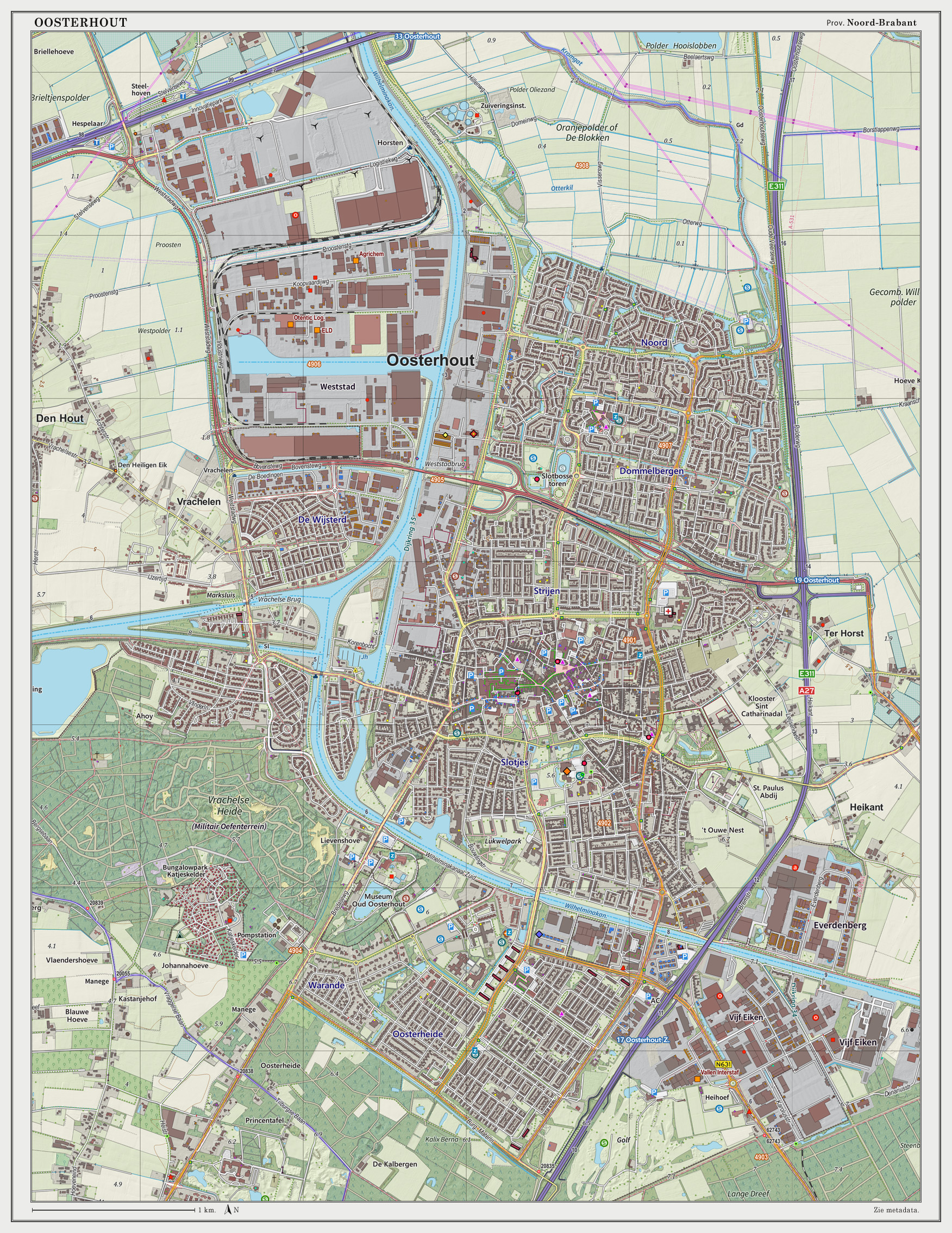
Topografische kaart van
Oosterhout (woonplaats). Resolutie: 300 pixels/km.
155:
Kaartbeeld samengesteld uit de open geodata van de Top10NL en Top25namen (
801:
163:
BY licentie. Gebouwvlakken uit open geodata BAG extract. Wegen uit de
609:
Click on a date/time to view the file as it appeared at that time.
93:
791:
330:
Add a one-line explanation of what this file represents
83:(1,752 × 2,268 pixels, file size: 2.13 MB, MIME type:
518:
Creative
Commons Attribution-ShareAlike 3.0 Unported
417:
https://commons.wikimedia.org/user:Janwillemvanaalst
137:
117:
Commons is a freely licensed media file repository.
167:. Reliëfschaduw uit de Actuele Hoogtekaart AHN2.
298:https://creativecommons.org/licenses/by-sa/3.0
98:
304:Creative Commons Attribution-Share Alike 3.0
228:
8:
264:– to copy, distribute and transmit the work
819:
611:
326:
774:The following other wikis use this file:
894:xmp.did:CF12383D047EE411956C80098F6338D5
889:
881:
873:
863:
855:
845:
837:
829:
821:
761:
585:
569:
551:
535:
515:
499:
479:
463:
396:
380:
360:
344:
341:
322:
315:
851:Adobe Photoshop Elements 12.0 Windows
7:
251:Attribution-Share Alike 3.0 Unported
749:User created page with UploadWizard
600:
239:
234:
812:
335:
329:
225:
221:
147:
130:
76:
334:
320:
275:Under the following conditions:
246:This file is licensed under the
238:
233:
227:
169:Samenstelling en kleurenschema:
97:
31:
21:
883:Date metadata was last modified
317:
14:
891:Unique ID of original document
316:
143:Oosterhout-plaats-OpenTopo.jpg
26:
1:
689:Map layers update, sept. 2014
588:original creation by uploader
148:
36:
719:Map layers update, June 2014
659:Map layers update, Dec. 2014
342:Items portrayed in this file
875:Date and time of digitizing
157:Basisregistratie Topografie
911:
802:Oosterhout (Noord-Brabant)
798:Usage on nl.wikipedia.org
788:Usage on ms.wikipedia.org
778:Usage on ar.wikipedia.org
289:same or compatible license
187:20 December 2014, 09:02:17
857:File change date and time
601:
196:
16:
319:
255:
173:, met QGIS2. Zie ook de
104:This is a file from the
748:
718:
688:
658:
637:10:36, 20 December 2014
202:
192:
185:
182:
140:
108:. Information from its
886:14:06, 7 December 2014
878:14:06, 7 December 2014
860:13:06, 7 December 2014
667:07:04, 16 October 2014
111:description page there
46:Size of this preview:
831:Horizontal resolution
727:13:57, 22 March 2014
171:Jan-Willem van Aalst
70:1,752 × 2,268 pixels
839:Vertical resolution
697:10:39, 28 June 2014
270:– to adapt the work
52:Other resolutions:
440:author name string
425:Wikimedia username
66:791 × 1,024 pixels
898:
897:
770:Global file usage
752:
744:Janwillemvanaalst
714:Janwillemvanaalst
684:Janwillemvanaalst
654:Janwillemvanaalst
502:copyright license
446:Janwillemvanaalst
432:Janwillemvanaalst
328:
212:
211:
207:Janwillemvanaalst
126:
125:
106:Wikimedia Commons
32:Global file usage
902:
820:
739:
709:
679:
649:
553:20 December 2014
466:copyright status
447:
444:
434:
429:
419:
414:
311:
308:
305:
302:
299:
291:as the original.
248:Creative Commons
242:
241:
237:
236:
231:
230:
198:
188:
161:Creative Commons
152:
144:
138:
122:
101:
100:
94:
88:
86:
73:
62:593 × 768 pixels
58:371 × 480 pixels
54:185 × 240 pixels
48:463 × 599 pixels
910:
909:
905:
904:
903:
901:
900:
899:
808:
768:
760:
753:
745:
737:
715:
707:
685:
677:
655:
647:
603:
602:
599:
598:
597:
596:
595:
594:
593:
592:
590:
578:
577:
576:
574:
563:
562:
561:
560:
559:
558:
557:
556:
554:
544:
543:
542:
540:
529:
528:
527:
526:
525:
524:
523:
522:
520:
508:
507:
506:
504:
493:
492:
491:
490:
489:
488:
487:
486:
484:
472:
471:
470:
468:
457:
456:
455:
454:
453:
452:
451:
450:
449:
448:
445:
442:
436:
435:
430:
427:
421:
420:
415:
412:
403:
402:
401:
399:
389:
388:
387:
385:
374:
373:
372:
371:
370:
369:
368:
367:
365:
353:
352:
351:
349:
333:
332:
331:
314:
313:
312:
309:
306:
303:
300:
297:
296:
254:
243:
224:
223:
218:
213:
178:
142:
135:
128:
127:
116:
115:
114:is shown below.
90:
84:
82:
75:
74:
51:
12:
11:
5:
908:
906:
896:
895:
892:
888:
887:
884:
880:
879:
876:
872:
871:
868:
862:
861:
858:
854:
853:
848:
844:
843:
840:
836:
835:
832:
828:
827:
824:
811:
807:
806:
805:
804:
796:
795:
794:
786:
785:
784:
772:
771:
767:
766:
758:
757:
756:
751:
750:
747:
743:
740:
736:1,752 × 2,268
734:
729:
724:
721:
720:
717:
713:
710:
706:1,752 × 2,268
704:
699:
694:
691:
690:
687:
683:
680:
676:1,752 × 2,268
674:
669:
664:
661:
660:
657:
653:
650:
646:1,752 × 2,268
644:
639:
634:
630:
629:
626:
623:
620:
617:
614:
607:
606:
591:
586:
584:
583:
582:
581:
580:
579:
575:
572:source of file
570:
568:
567:
566:
565:
564:
555:
552:
550:
549:
548:
547:
546:
545:
541:
536:
534:
533:
532:
531:
530:
521:
516:
514:
513:
512:
511:
510:
509:
505:
500:
498:
497:
496:
495:
494:
485:
480:
478:
477:
476:
475:
474:
473:
469:
464:
462:
461:
460:
459:
458:
438:
437:
423:
422:
408:
407:
406:
405:
404:
400:
397:
395:
394:
393:
392:
391:
390:
386:
381:
379:
378:
377:
376:
375:
366:
361:
359:
358:
357:
356:
355:
354:
350:
345:
343:
340:
339:
338:
337:
336:
325:
324:
321:
318:
295:
294:
293:
292:
282:
273:
272:
271:
265:
258:You are free:
245:
244:
226:
220:
219:
217:
214:
210:
209:
204:
200:
199:
194:
190:
189:
184:
180:
179:
145:
136:
134:
131:
129:
124:
123:
102:
92:
91:
45:
41:
40:
39:
34:
29:
24:
19:
13:
10:
9:
6:
4:
3:
2:
907:
893:
890:
885:
882:
877:
874:
869:
867:
864:
859:
856:
852:
849:
847:Software used
846:
841:
838:
833:
830:
825:
822:
818:
815:
809:
803:
800:
799:
797:
793:
790:
789:
787:
783:
780:
779:
777:
776:
775:
769:
765:
762:
754:
746:
741:
735:
733:
730:
728:
725:
723:
722:
716:
711:
705:
703:
700:
698:
695:
693:
692:
686:
681:
675:
673:
670:
668:
665:
663:
662:
656:
651:
645:
643:
640:
638:
635:
632:
631:
627:
624:
621:
618:
615:
613:
612:
610:
604:
589:
573:
539:
519:
503:
483:
467:
441:
433:
426:
418:
411:
384:
364:
348:
301:CC BY-SA 3.0
290:
286:
283:
280:
277:
276:
274:
269:
266:
263:
260:
259:
257:
256:
252:
249:
232:
215:
208:
205:
201:
195:
191:
181:
176:
172:
168:
166:
165:OpenStreetMap
162:
159:, Kadaster),
158:
151:
146:
139:
132:
120:
113:
112:
107:
103:
96:
95:
89:
80:
79:Original file
71:
67:
63:
59:
55:
49:
44:
38:
35:
33:
30:
28:
25:
23:
20:
18:
15:
816:
813:
773:
608:
605:File history
284:
278:
267:
261:
154:
150:Nederlands:
149:
119:You can help
109:
77:
22:File history
866:Color space
823:Orientation
482:copyrighted
285:share alike
279:attribution
141:Description
792:Oosterhout
764:Oosterhout
755:File usage
622:Dimensions
398:some value
85:image/jpeg
27:File usage
782:أوسترهاوت
738:(2.07 MB)
708:(2.85 MB)
678:(3.02 MB)
648:(2.13 MB)
619:Thumbnail
616:Date/Time
538:inception
216:Licensing
810:Metadata
323:Captions
268:to remix
262:to share
253:license.
197:Own work
37:Metadata
633:current
628:Comment
383:creator
347:depicts
327:English
175:Legenda
133:Summary
81:
842:72 dpi
834:72 dpi
826:Normal
203:Author
193:Source
870:sRGB
625:User
310:true
307:true
183:Date
17:File
410:URL
363:map
443::
428::
413::
68:|
64:|
60:|
56:|
50:.
177:.
121:.
87:)
72:.
Text is available under the Creative Commons Attribution-ShareAlike License. Additional terms may apply.