328:
261:
219:
275:
233:
296:
334:
339:
67:
1024:
38:
252:
210:
1041:== {{int:filedesc}} == {{Information |description={{en|1=Oakley: Bedford to Wellingborough railway line. Viewed looking southwards from the Highfield Road overbridge, the distant twin arched bridge is the Railway Cottages bridge. The long since dismantled
121:
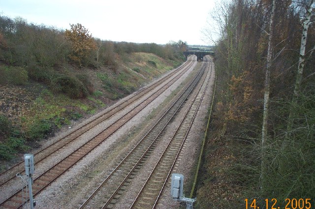
Oakley: Bedford to
Wellingborough railway line. Viewed looking southwards from the Highfield Road overbridge, the distant twin arched bridge is the Railway Cottages bridge. The long since dismantled Oakley railway station was just beyond that
78:
46:
386:– You must give appropriate credit, provide a link to the license, and indicate if changes were made. You may do so in any reasonable manner, but not in any way that suggests the licensor endorses you or your use.
1023:
1018:
37:
1055:
672:
602:
566:
268:
226:
1088:
827:
692:
1174:
303:
1066:
This file contains additional information, probably added from the digital camera or scanner used to create or digitize it.
393:
529:
955:
918:
884:
847:
811:
777:
743:
700:
656:
550:
522:
509:
494:
715:
685:
622:
586:
467:
450:
290:
349:
1069:
If the file has been modified from its original state, some details may not fully reflect the modified file.
1051:
The following pages on the
English Knowledge (XXG) use this file (pages on other projects are not listed):
1211:
1078:
392:– If you remix, transform, or build upon the material, you must distribute your contributions under the
310:
on the
Geograph website for the photographer's contact details. The copyright on this image is owned by
1034:
346:
1247:
86:
179:
501:
163:
722:
707:
274:
232:
1229:
1193:
1103:
315:
73:
1132:
1257:
131:
258:
216:
111:
Oakley, Bedford to
Wellingborough railway line - geograph.org.uk - 91320.jpg
47:
Oakley,_Bedford_to_Wellingborough_railway_line_-_geograph.org.uk_-_91320.jpg
152:
142:
1113:
295:
307:
991:
Click on a date/time to view the file as it appeared at that time.
260:
218:
243:
201:
61:
736:
770:
253:
52° 10′ 25″ N, 0° 31′ 08″ W
211:
52° 10′ 31″ N, 0° 31′ 16″ W
434:
Add a one-line explanation of what this file represents
105:
85:
Commons is a freely licensed media file repository.
603:
Creative
Commons Attribution-ShareAlike 2.0 Generic
51:(640 × 425 pixels, file size: 105 KB, MIME type:
403:https://creativecommons.org/licenses/by-sa/2.0
194:Oakley: Bedford to Wellingborough railway line
175:Oakley: Bedford to Wellingborough railway line
66:
409:Creative Commons Attribution-Share Alike 2.0
327:
8:
369:– to copy, distribute and transmit the work
1071:
993:
430:
502:https://www.geograph.org.uk/profile/2798
1273:
1265:
1255:
1245:
1237:
1227:
1219:
1209:
1201:
1191:
1183:
1172:
1164:
1156:
1148:
1140:
1129:
1121:
1111:
1101:
1093:
1083:
1053:
969:
953:
932:
916:
898:
882:
861:
845:
825:
809:
791:
775:
757:
741:
723:https://www.geograph.org.uk/photo/91320
670:
654:
636:
620:
600:
584:
564:
548:
481:
465:
448:
445:
426:
419:
246:
204:
267:View this and other nearby images on:
225:View this and other nearby images on:
1073:
1056:Oakley railway station (Bedfordshire)
7:
314:and is licensed for reuse under the
982:
350:Attribution-Share Alike 2.0 Generic
338:
333:
318:Attribution-ShareAlike 2.0 license.
1064:
439:
433:
324:
301:
115:
98:
44:
438:
1123:Date and time of data generation
1098:KODAK DC280 ZOOM DIGITAL CAMERA
744:coordinates of the point of view
424:
380:Under the following conditions:
345:This file is licensed under the
337:
332:
326:
294:
273:
259:
231:
217:
65:
21:
1089:KODAK DC280 ZOOM DIGITAL CAMERA
421:
116:
41:No higher resolution available.
14:
673:file available on the internet
420:
302:This image was taken from the
26:
1:
778:coordinates of depicted place
31:
1108:1/30 sec (0.033333333333333)
693:Geograph Britain and Ireland
523:object of statement has role
446:Items portrayed in this file
1185:Date and time of digitizing
1295:
1278:One-chip color area sensor
394:same or compatible license
983:
759:52°10'31.4"N, 0°31'15.6"W
16:
793:52°10'25.0"N, 0°31'8.4"W
701:geograph.org.uk image ID
423:
360:
72:This is a file from the
1188:14:00, 14 December 2005
1126:14:00, 14 December 2005
1040:
863:0.03333333333333333333
164:required by the license
148:
137:
130:
127:
108:
76:. Information from its
1019:23:53, 30 January 2010
308:this photograph's page
279:52.173600; -0.519000
237:52.175400; -0.521000
192:Nigel Cox /
173:Nigel Cox /
79:description page there
1221:Maximum land aperture
1150:Horizontal resolution
1079:EASTMAN KODAK COMPANY
1166:Y and C positioning
1158:Vertical resolution
1075:Camera manufacturer
375:– to adapt the work
1252:Flash did not fire
510:author name string
1282:
1281:
1224:3.1 APEX (f/2.93)
1044:
587:copyright license
432:
323:
322:
306:collection. See
284:
283:
242:
241:
199:
198:
167:
94:
93:
74:Wikimedia Commons
1286:
1095:Copyright holder
1072:
1031:
937:
866:
828:Kodak DC280 Zoom
725:
720:
716:described at URL
710:
705:
695:
690:
638:14 December 2005
551:copyright status
532:
527:
517:
514:
504:
499:
416:
413:
410:
407:
404:
396:as the original.
358:
347:Creative Commons
341:
340:
336:
335:
330:
329:
316:Creative Commons
304:Geograph project
298:
291:
280:
277:
263:
262:
256:
255:
244:
238:
235:
221:
220:
214:
213:
202:
161:
133:
132:14 December 2005
120:
112:
106:
90:
69:
68:
62:
56:
54:
1294:
1293:
1289:
1288:
1287:
1285:
1284:
1283:
1060:
1052:
1045:
1037:
1029:
985:
984:
981:
980:
979:
978:
977:
976:
975:
974:
972:
962:
961:
960:
958:
947:
946:
945:
944:
943:
942:
941:
940:
938:
935:
925:
924:
923:
921:
910:
909:
908:
907:
906:
905:
904:
903:
901:
891:
890:
889:
887:
876:
875:
874:
873:
872:
871:
870:
869:
867:
864:
854:
853:
852:
850:
839:
838:
837:
836:
835:
834:
833:
832:
830:
818:
817:
816:
814:
803:
802:
801:
800:
799:
798:
797:
796:
794:
784:
783:
782:
780:
769:
768:
767:
766:
765:
764:
763:
762:
760:
750:
749:
748:
746:
735:
734:
733:
732:
731:
730:
729:
728:
727:
726:
721:
718:
712:
711:
706:
703:
697:
696:
691:
688:
679:
678:
677:
675:
663:
662:
661:
659:
648:
647:
646:
645:
644:
643:
642:
641:
639:
629:
628:
627:
625:
614:
613:
612:
611:
610:
609:
608:
607:
605:
593:
592:
591:
589:
578:
577:
576:
575:
574:
573:
572:
571:
569:
557:
556:
555:
553:
542:
541:
540:
539:
538:
537:
536:
535:
534:
533:
528:
525:
519:
518:
515:
512:
506:
505:
500:
497:
488:
487:
486:
484:
474:
473:
472:
470:
459:
458:
457:
456:
455:
453:
437:
436:
435:
418:
417:
414:
411:
408:
405:
402:
401:
359:
356:
353:
342:
319:
289:
278:
251:
250:
247:Object location
236:
209:
208:
205:Camera location
200:
189:
182:
170:
143:geograph.org.uk
123:
110:
103:
96:
95:
84:
83:
82:is shown below.
58:
52:
50:
43:
42:
12:
11:
5:
1292:
1290:
1280:
1279:
1276:
1275:Sensing method
1272:
1271:
1268:
1267:Exposure index
1264:
1263:
1260:
1254:
1253:
1250:
1244:
1243:
1240:
1236:
1235:
1232:
1226:
1225:
1222:
1218:
1217:
1214:
1208:
1207:
1204:
1200:
1199:
1196:
1190:
1189:
1186:
1182:
1181:
1178:
1171:
1170:
1167:
1163:
1162:
1159:
1155:
1154:
1151:
1147:
1146:
1143:
1139:
1138:
1135:
1128:
1127:
1124:
1120:
1119:
1116:
1110:
1109:
1106:
1100:
1099:
1096:
1092:
1091:
1086:
1082:
1081:
1076:
1063:
1059:
1058:
1050:
1049:
1048:
1043:
1042:
1039:
1035:
1032:
1026:
1021:
1016:
1012:
1011:
1008:
1005:
1002:
999:
996:
989:
988:
973:
970:
968:
967:
966:
965:
964:
963:
959:
954:
952:
951:
950:
949:
948:
939:
933:
931:
930:
929:
928:
927:
926:
922:
917:
915:
914:
913:
912:
911:
902:
899:
897:
896:
895:
894:
893:
892:
888:
883:
881:
880:
879:
878:
877:
868:
862:
860:
859:
858:
857:
856:
855:
851:
846:
844:
843:
842:
841:
840:
831:
826:
824:
823:
822:
821:
820:
819:
815:
810:
808:
807:
806:
805:
804:
795:
792:
790:
789:
788:
787:
786:
785:
781:
776:
774:
773:
772:
771:
761:
758:
756:
755:
754:
753:
752:
751:
747:
742:
740:
739:
738:
737:
714:
713:
699:
698:
684:
683:
682:
681:
680:
676:
671:
669:
668:
667:
666:
665:
664:
660:
657:source of file
655:
653:
652:
651:
650:
649:
640:
637:
635:
634:
633:
632:
631:
630:
626:
621:
619:
618:
617:
616:
615:
606:
601:
599:
598:
597:
596:
595:
594:
590:
585:
583:
582:
581:
580:
579:
570:
565:
563:
562:
561:
560:
559:
558:
554:
549:
547:
546:
545:
544:
543:
521:
520:
508:
507:
493:
492:
491:
490:
489:
485:
482:
480:
479:
478:
477:
476:
475:
471:
466:
464:
463:
462:
461:
460:
454:
449:
447:
444:
443:
442:
441:
440:
429:
428:
425:
422:
400:
399:
398:
397:
387:
378:
377:
376:
370:
363:You are free:
354:
344:
343:
325:
321:
320:
299:
288:
285:
282:
281:
271:
265:
248:
240:
239:
229:
223:
206:
197:
196:
190:
187:
184:
183:
178:
171:
168:
156:
155:
150:
146:
145:
139:
135:
134:
129:
125:
124:
113:
104:
102:
99:
97:
92:
91:
70:
60:
59:
40:
36:
35:
34:
29:
24:
19:
13:
10:
9:
6:
4:
3:
2:
1291:
1277:
1274:
1269:
1266:
1261:
1259:
1256:
1251:
1249:
1246:
1241:
1238:
1233:
1231:
1230:Metering mode
1228:
1223:
1220:
1215:
1213:
1212:Exposure bias
1210:
1205:
1203:APEX aperture
1202:
1197:
1195:
1194:Shutter speed
1192:
1187:
1184:
1179:
1176:
1173:
1168:
1165:
1160:
1157:
1152:
1149:
1144:
1141:
1136:
1134:
1130:
1125:
1122:
1117:
1115:
1112:
1107:
1105:
1104:Exposure time
1102:
1097:
1094:
1090:
1087:
1084:
1080:
1077:
1074:
1070:
1067:
1061:
1057:
1054:
1046:
1038:
1033:
1027:
1025:
1022:
1020:
1017:
1014:
1013:
1009:
1006:
1003:
1000:
997:
995:
994:
992:
986:
957:
920:
886:
849:
848:exposure time
829:
813:
812:captured with
779:
745:
724:
717:
709:
702:
694:
687:
674:
658:
624:
604:
588:
568:
552:
531:
524:
511:
503:
496:
469:
452:
406:CC BY-SA 2.0
395:
391:
388:
385:
382:
381:
379:
374:
371:
368:
365:
364:
362:
361:
355:Attribution:
351:
348:
331:
317:
313:
309:
305:
300:
297:
293:
292:
286:
276:
272:
270:
269:OpenStreetMap
266:
264:
254:
249:
245:
234:
230:
228:
227:OpenStreetMap
224:
222:
212:
207:
203:
195:
191:
186:
185:
181:
177: /
176:
172:
165:
160:
158:
157:
154:
151:
147:
144:
140:
136:
126:
119:
114:
107:
100:
88:
81:
80:
75:
71:
64:
63:
57:
48:
39:
33:
30:
28:
25:
23:
20:
18:
15:
1239:Light source
1133:focal length
1085:Camera model
1068:
1065:
990:
987:File history
919:focal length
530:photographer
389:
383:
372:
366:
311:
193:
180:CC BY-SA 2.0
174:
117:
87:You can help
77:
45:
22:File history
1258:Color space
1142:Orientation
1036:GeographBot
567:copyrighted
390:share alike
384:attribution
159:Attribution
109:Description
1047:File usage
1028:640 × 425
1004:Dimensions
971:image/jpeg
956:media type
936:millimetre
483:some value
53:image/jpeg
27:File usage
1001:Thumbnail
998:Date/Time
623:inception
516:Nigel Cox
357:Nigel Cox
312:Nigel Cox
287:Licensing
188:InfoField
169:InfoField
153:Nigel Cox
118:English:
1242:Daylight
1169:Centered
1114:F-number
1062:Metadata
1030:(105 KB)
885:f-number
686:operator
427:Captions
373:to remix
367:to share
352:license.
32:Metadata
1234:Average
1177:version
1161:192 dpi
1153:192 dpi
1015:current
1010:Comment
468:creator
451:depicts
431:English
122:bridge.
101:Summary
49:
1145:Normal
1137:6.3 mm
865:second
257:
215:
149:Author
138:Source
1248:Flash
1131:Lens
708:91320
141:From
1262:sRGB
1175:Exif
1007:User
934:6.3
415:true
412:true
128:Date
17:File
1270:200
1206:3.1
1180:2.1
1118:f/3
495:URL
719::
704::
689::
526::
513::
498::
1216:0
1198:5
900:3
166:)
162:(
89:.
55:)
Text is available under the Creative Commons Attribution-ShareAlike License. Additional terms may apply.
_&language=en)
_&language=en)
