321:
149:
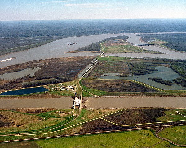
right. Control structures (dams) at each of the three forks of the
Atchafalaya prevent most of the waters of the Mississippi from running into the Atchafalaya. The design of the structures is intended to keep 70% of the water in the Mississippi and 30% flowing into the Atchafalaya. View is to the east-southeast. The control structures are located at river mile 315 on the Mississippi (315 miles from the Gulf of Mexico). On the left of the river in this photograph is Wilkinson County in the State of Mississippi. Concordia Parish, Louisiana is on the right.
43:
364:
378:
243:
99:
158:
régulation (barrages) à chacune des branches de l'Atchafalaya empêchent la plupart des eaux du
Mississippi de se déverser dans l'Atchafalaya. Ces structures sont conçues pour conserver 70% du débit dans le Mississippi et 30% dans l'Atchafalaya. La vue est vers l'est-sud-est. Les structures de régulation sont situées au point
157:
La structure de régulation des eaux d'Old River, au défluent du
Mississippi et de l'Atchafalaya. Sur cette photographie, le Mississippi coule depuis la gauche vers l'arrière-plan à droite. L'Atchafalaya part du Mississippi depuis trois points et coule vers l'avant-plan à droite. Les ouvrages de
148:
The Old River
Control Structure at the juncture of the Mississippi River and the Atchafalaya River. In this photograph, the Mississippi River enters from the left and curves away to the right in the distance. The Atchafalaya River meets the Mississippi at three points and runs off to the bottom
645:
662:{{Information | Description = {{en|The Old River Control Structure at the juncture of the Mississippi River and the Atchafalaya River. In this photograph, the Mississippi River runs along the left and curves away to the right in the distance. The Atcha
162:à 506 km en amont de l'embouchure du Mississippi. Sur le côté gauche du Mississippi se trouve le comté de Wilkinson dans l'État du Mississippi. Sur le côté droit se trouve la paroisse de Concordia, en Louisiane.
355:
187:
65:
61:
57:
53:
47:
110:
78:
259:
709:
255:
210:
691:
487:
371:
792:
This file contains additional information, probably added from the digital camera or scanner used to create or digitize it.
676:
452:
311:
576:
542:
465:
436:
686:
508:
480:
419:
472:
749:
795:
If the file has been modified from its original state, some details may not fully reflect the modified file.
672:
The following pages on the
English Knowledge (XXG) use this file (pages on other projects are not listed):
644:
639:
251:
69:
42:
118:
734:
681:
294:
306:
302:
298:
290:
286:
282:
278:
274:
183:
377:
264:
105:
361:
254:
soldier or employee, taken or made as part of that person's official duties. As a
769:
171:
655:
739:
724:
759:
612:
Click on a date/time to view the file as it appeared at that time.
340:
Wilkinson County, MIssissippi and
Concordia County, Louisiana, USA
719:
535:
363:
356:
31° 05′ 17.73″ N, 91° 37′ 07.87″ W
191:
346:
237:
93:
319:
403:
Add a one-line explanation of what this file represents
83:(1,500 × 1,200 pixels, file size: 1.02 MB, MIME type:
779:
132:
117:
Commons is a freely licensed media file repository.
488:
work of the federal government of the United States
181:
U.S. Army Corps of
Engineers Digital Visual Library
735:Structure de régulation des eaux d'Old River
98:
8:
201:Michael Maples, U.S. Army Corps of Engineers
797:
614:
399:
310:
217:
702:The following other wikis use this file:
799:
674:
590:
574:
556:
540:
522:
506:
450:
434:
417:
414:
395:
388:
349:
138:Old River Control Structure Complex.jpg
370:View this and other nearby images on:
242:
7:
804:File written by Adobe Photoshop¨ 5.0
603:
790:
770:Estrutura de controle do Rio Velho
408:
402:
250:This image or file is a work of a
248:
151:
142:
130:
76:
407:
692:Talk:Mississippi River/Archive 2
543:coordinates of the point of view
393:
376:
362:
241:
192:Digital Visual Library home page
97:
31:
21:
390:
143:
14:
389:
152:
26:
1:
677:2011 Mississippi River floods
36:
558:31°5'17.729"N, 91°37'7.871"W
415:Items portrayed in this file
252:U.S. Army Corps of Engineers
740:Mississippi Valley Division
725:Old River Control Structure
687:Old River Control Structure
821:
776:Usage on www.wikidata.org
766:Usage on pt.wikipedia.org
756:Usage on nl.wikipedia.org
746:Usage on he.wikipedia.org
731:Usage on fr.wikipedia.org
716:Usage on de.wikipedia.org
706:Usage on bg.wikipedia.org
604:
16:
760:Old River Control System
473:United States of America
392:
104:This is a file from the
661:
466:applies to jurisdiction
260:U.S. federal government
205:
197:
177:
170:
167:
135:
108:. Information from its
382:31.088258; -91.618853
324:
262:, the image is in the
188:Image description page
111:description page there
46:Size of this preview:
323:
720:Mississippiflut 2011
481:determination method
70:1,500 × 1,200 pixels
66:1,280 × 1,024 pixels
640:03:50, 6 April 2007
52:Other resolutions:
325:
808:
807:
801:JPEG file comment
710:Мисисипска низина
698:Global file usage
682:Mississippi River
665:
401:
387:
386:
344:
343:
329:
328:
314:
236:
235:
214:
211:Reusing this file
126:
125:
106:Wikimedia Commons
32:Global file usage
812:
798:
652:
490:
485:
475:
470:
437:copyright status
383:
380:
366:
365:
359:
358:
347:
322:
315:
245:
244:
238:
232:
229:
226:
223:
218:
208:
173:
156:
154:Français :
147:
139:
133:
122:
101:
100:
94:
88:
86:
73:
62:960 × 768 pixels
58:600 × 480 pixels
54:300 × 240 pixels
48:750 × 600 pixels
820:
819:
815:
814:
813:
811:
810:
809:
786:
696:
673:
666:
658:
650:
606:
605:
602:
601:
600:
599:
598:
597:
596:
595:
593:
583:
582:
581:
579:
568:
567:
566:
565:
564:
563:
562:
561:
559:
549:
548:
547:
545:
534:
533:
532:
531:
530:
529:
528:
527:
525:
515:
514:
513:
511:
500:
499:
498:
497:
496:
495:
494:
493:
492:
491:
486:
483:
477:
476:
471:
468:
459:
458:
457:
455:
443:
442:
441:
439:
428:
427:
426:
425:
424:
422:
406:
405:
404:
381:
354:
353:
350:Camera location
345:
337:
320:
273:
270:
230:
227:
224:
221:
163:
150:
137:
128:
127:
116:
115:
114:is shown below.
90:
84:
82:
75:
74:
51:
12:
11:
5:
818:
816:
806:
805:
802:
789:
785:
784:
783:
782:
774:
773:
772:
764:
763:
762:
754:
753:
752:
750:מיסיסיפי (נהר)
744:
743:
742:
737:
729:
728:
727:
722:
714:
713:
712:
700:
699:
695:
694:
689:
684:
679:
671:
670:
669:
664:
663:
660:
656:
653:
649:1,500 × 1,200
647:
642:
637:
633:
632:
629:
626:
623:
620:
617:
610:
609:
594:
591:
589:
588:
587:
586:
585:
584:
580:
575:
573:
572:
571:
570:
569:
560:
557:
555:
554:
553:
552:
551:
550:
546:
541:
539:
538:
537:
536:
526:
523:
521:
520:
519:
518:
517:
516:
512:
507:
505:
504:
503:
502:
501:
479:
478:
464:
463:
462:
461:
460:
456:
451:
449:
448:
447:
446:
445:
444:
440:
435:
433:
432:
431:
430:
429:
423:
418:
416:
413:
412:
411:
410:
409:
398:
397:
394:
391:
385:
384:
374:
368:
351:
342:
341:
338:
335:
331:
330:
327:
326:
317:
246:
234:
233:
215:
203:
202:
199:
195:
194:
179:
175:
174:
169:
165:
164:
140:
131:
129:
124:
123:
102:
92:
91:
45:
41:
40:
39:
34:
29:
24:
19:
13:
10:
9:
6:
4:
3:
2:
817:
803:
800:
796:
793:
787:
781:
778:
777:
775:
771:
768:
767:
765:
761:
758:
757:
755:
751:
748:
747:
745:
741:
738:
736:
733:
732:
730:
726:
723:
721:
718:
717:
715:
711:
708:
707:
705:
704:
703:
697:
693:
690:
688:
685:
683:
680:
678:
675:
667:
659:
654:
648:
646:
643:
641:
638:
635:
634:
630:
627:
624:
621:
618:
616:
615:
613:
607:
578:
544:
510:
489:
482:
474:
467:
454:
453:public domain
438:
421:
379:
375:
373:
372:OpenStreetMap
369:
367:
357:
352:
348:
339:
333:
332:
318:
316:
313:
308:
304:
300:
296:
292:
288:
284:
280:
276:
271:
269:
267:
266:
265:public domain
261:
257:
253:
247:
240:
239:
225:Public domain
222:Public domain
220:
219:
216:
212:
207:
204:
200:
196:
193:
190:
189:
186:
185:
182:
180:
176:
166:
161:
155:
146:
141:
134:
120:
113:
112:
107:
103:
96:
95:
89:
80:
79:Original file
71:
67:
63:
59:
55:
49:
44:
38:
35:
33:
30:
28:
25:
23:
20:
18:
15:
794:
791:
701:
611:
608:File history
272:
263:
249:
159:
153:
144:
119:You can help
109:
77:
22:File history
299:slovenščina
136:Description
668:File usage
625:Dimensions
592:image/jpeg
577:media type
524:5 May 1999
307:українська
283:Nederlands
206:Permission
184:Image page
172:5 May 1999
85:image/jpeg
27:File usage
651:(1.02 MB)
622:Thumbnail
619:Date/Time
509:inception
336:InfoField
295:sicilianu
145:English:
788:Metadata
780:Q1164957
396:Captions
334:Location
309: |
305: |
301: |
297: |
293: |
289: |
285: |
281: |
279:italiano
277: |
160:mile 315
37:Metadata
636:current
631:Comment
420:depicts
400:English
291:русский
275:English
258:of the
81:
360:
303:Türkçe
198:Author
178:Source
657:DanMS
231:false
228:false
628:User
287:پښتو
256:work
168:Date
17:File
312:+/−
484::
469::
68:|
64:|
60:|
56:|
50:.
268:.
213:)
209:(
121:.
87:)
72:.
Text is available under the Creative Commons Attribution-ShareAlike License. Additional terms may apply.
