43:
361:
1166:
390:
523:
486:
404:
463:
1172:
471:
481:
570:
511:
1791:
99:
1692:
519:
1876:
1906:
1886:
1871:
1709:{{Information |Description={{en|1=Oxbow Bend outlook in the Grand Teton National Park. View over the Snake River to the Mount Moran with the Skillet Glacier (12605 ft), Bivouac Peak (10825 ft) and Eagles Rest Peak (11258 ft) in the Grand Teton, Wyoming, U
1901:
1002:
981:
503:
381:
2165:
1222:– You must give appropriate credit, provide a link to the license, and indicate if changes were made. You may do so in any reasonable manner, but not in any way that suggests the licensor endorses you or your use.
2141:
2031:
2086:
1881:
65:
61:
57:
53:
47:
110:
78:
1743:
1761:
1931:
1733:
1738:
1911:
1976:
1896:
2156:
1866:
2151:
1089:
1046:
960:
1569:
1499:
1463:
1427:
397:
1135:
1122:
985:
2176:
This file contains additional information, probably added from the digital camera or scanner used to create or digitize it.
1390:
1856:
543:
1347:
1691:
1686:
1110:
727:
595:
414:
69:
42:
1623:
1589:
1553:
1483:
1411:
1383:
1368:
1355:
1340:
1054:
217:(3.842 m mit dem Skillet Glacier), des Bivouac Peak (3.299 m) und des Eagles Rest Peak (3.431 m) in dem
2260:
1519:
1447:
1313:
1293:
1277:
939:
838:
768:
274:
640:
154:
1723:
1030:
964:
797:
234:
1081:
1073:
1065:
1061:
360:
2179:
If the file has been modified from its original state, some details may not fully reflect the modified file.
1946:
914:
694:
669:
198:
1702:
578:
1182:
462:
499:
1771:
1179:
713:(3842 m mit dem Skillet Glacier), des Bivouac Peak (3299 m) und des Eagles Rest Peak (3431 m) in dem
1375:
857:) per una regione che conserva alcuni tra i depositi geologici più antichi del pianeta, come alcuni
659:
Skillet (3 842 m), Bivouac Peak (3 300 m) a Eagles Rest Peak (3 431 m)
293:) per una regione che conserva alcuni tra i depositi geologici più antichi del pianeta, come alcuni
1069:
583:
539:
118:
2061:
1191:
1156:
428:
346:
2111:
1996:
1986:
900:(Snakerivier) en de erachter gelegen berg Mount Moran met de gletsjer Skiller en de bergtoppen
747:
615:
174:
2136:
2091:
2051:
1821:
780:
2101:
2076:
1891:
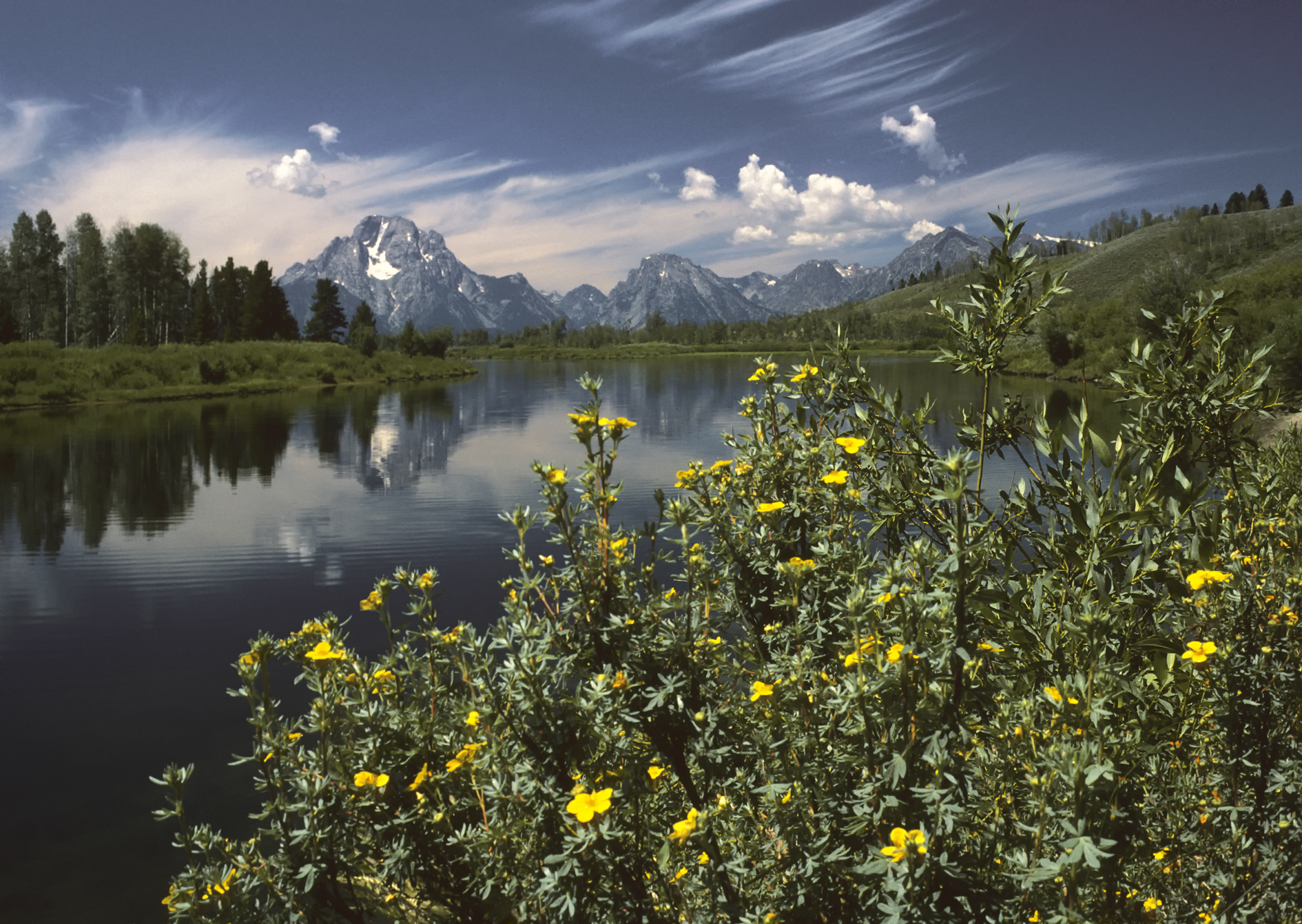
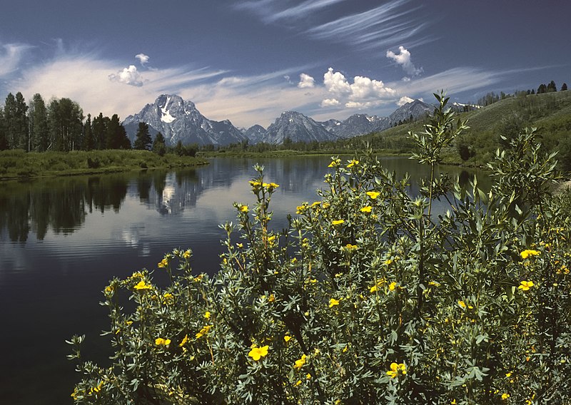
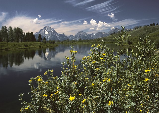
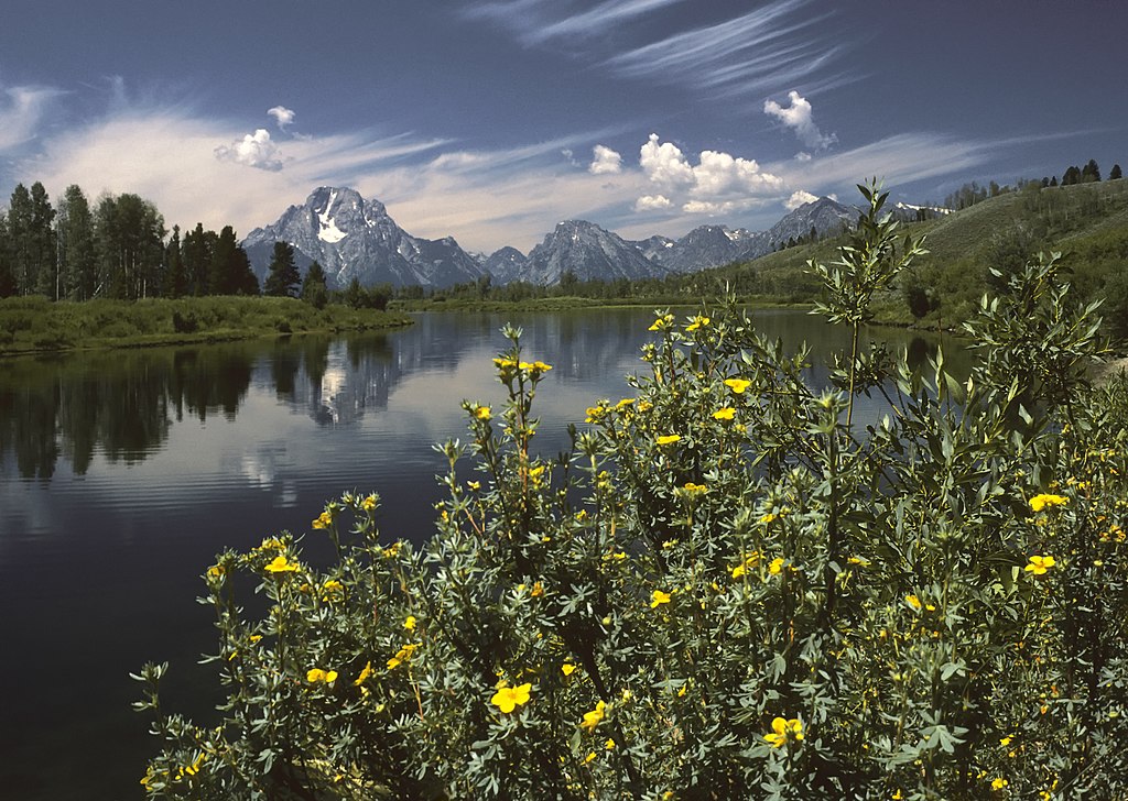
739:
735:
731:
702:
652:
644:
607:
603:
599:
306:
206:
166:
1006:
801:
238:
2021:
2006:
850:
286:
1097:
314:
1781:
680:
og bagved Mount Moran (3.842 m), Bivouac Peak (3.299 m) og Eagles Rest Peak (3.431 m) i
186:
2071:
1050:
927:
531:
438:
403:
743:
648:
611:
170:
1887:ویکیپدیا:گزیدن نگاره برگزیده/Oxbow Bend outlook in the Grand Teton National Park.jpg
1159:, the copyright holder of this work, hereby publishes it under the following license:
105:
1941:
923:
834:
387:
270:
178:
162:
158:
866:
535:
310:
302:
2275:
1728:
764:
947:
896:
846:
817:
776:
714:
710:
706:
681:
677:
282:
254:
218:
214:
210:
2121:
1034:
1093:
1085:
1077:
1058:
805:
242:
326:
285:- con il Monte Moran (3 842 m) sulla sinistra - una catena delle
1921:
968:
182:
2016:
1857:
Nachrichten:2017-01-04: New York Times stellt 52 Reiseziele für 2017 vor
564:
1851:
919:
879:
842:
830:
772:
760:
698:
656:
418:
278:
266:
202:
1811:
530:
If you have an image of similar quality that can be published under a
2126:
1951:
862:
858:
298:
294:
2041:
1841:
1659:
Click on a date/time to view the file as it appeared at that time.
1582:
943:
854:
290:
849:- con il Monte Moran (3 842 m) sulla sinistra - una catena delle
522:) and is considered one of the finest images. See its nomination
502:) and is considered one of the finest images. See its nomination
382:
43° 51′ 56.81″ N, 110° 32′ 51.49″ W
779:—con el Monte Moran (3842 m) a la izquierda—, una cadena de las
389:
883:
673:
372:
93:
461:
1961:
1966:
1831:
1261:
Add a one-line explanation of what this file represents
143:
Oxbow Bend outlook in the Grand Teton
National Park.jpg
2152:
Knowledge:Danh sách hình ảnh chọn lọc của
Commons/2009
750:(11258 ft) in the Teton Range, Wyoming, United States.
618:(11258 ft) in the Teton Range, Wyoming, United States.
83:(1,890 × 1,343 pixels, file size: 1.74 MB, MIME type:
1744:
Knowledge talk:Knowledge
Signpost/Newsroom/Archive 28
137:
117:
Commons is a freely licensed media file repository.
2062:
Wikiprojekt:Ilustrowanie/Medalowe zasoby
Commons/12
1801:
309:(3 842 m) sul Monte Moran, e le cime del
2157:Thảo luận Thành viên:Phương Huy/Phong cảnh/Sa mạc
2022:Knowledge:Sary/Sarin'ny anio/16 Oktobra 2022
1376:https://commons.wikimedia.org/User:Michael_Gäbler
2077:Knowledge:Imagem em destaque/20 de julho de 2010
1734:Knowledge:Knowledge Signpost/2022-11-28/Obituary
449:
1739:Knowledge:Knowledge Signpost/Single/2022-11-28
245:avec le Skillet Glacier, (3 842 m),
98:
1165:
8:
2007:Wikimedia Blog/Drafts/Michael Gabler profile
1947:Wikipédia:Kezdőlapműhely/A nap képe/2010-07
1229:https://creativecommons.org/licenses/by/3.0
1205:– to copy, distribute and transmit the work
2181:
2072:Knowledge:Imagem em destaque/Julho de 2010
1907:درگاه:ایالات متحده آمریکا/نگاره برگزیده/۳۵
1792:উইকিপিডিয়া:আজকের নির্বাচিত ছবি/জুলাই ২০১০
1661:
1257:
569:
1877:ویکیپدیا:گزیدن نگاره برگزیده/نوامبر-۲۰۱۲
1754:The following other wikis use this file:
1464:Creative Commons Attribution 3.0 Unported
480:
470:
2273:
2265:
2255:
2247:
2239:
2231:
2223:
2215:
2207:
2199:
2191:
2183:
1902:درگاه:ایالات متحده آمریکا/نگاره برگزیده
1721:
1637:
1621:
1603:
1587:
1567:
1551:
1533:
1517:
1497:
1481:
1461:
1445:
1425:
1409:
1327:
1311:
1291:
1275:
1272:
1253:
1246:
1127:
437:
427:
417:
375:
356:
1872:ویکیپدیا:نگارههای برگزیده/جاها/طبیعت
396:View this and other nearby images on:
1719:The following 5 pages use this file:
922:. De bergen vormen onderdeel van het
853:di formazione piuttosto recente (6-9
305:. Nella foto si distinguono anche il
289:di formazione piuttosto recente (6-9
177:(11,258 ft/3,431 m) in the
7:
808:avec le Skillet Glacier, (3 842 m),
1650:
1171:
959:Поглед на дел од националниот парк
518:on the Persian language Knowledge (
2174:
2032:Википедија:Избрана слика/2010/јули
1570:Wikimedia Commons featured picture
1266:
1260:
1196:
1162:
1154:
1114:
1102:
1039:
990:
973:
952:
932:
887:
871:
822:
800:, Wyoming, États-Unis. Vue sur la
785:
752:
719:
686:
661:
628:
588:
448:
259:
237:, Wyoming, États-Unis. Vue sur la
223:
191:
173:(10,825 ft/3,299 m) and
147:
130:
76:
2122:Knowledge:Tidigare utvalda bilder
1265:
1235:Creative Commons Attribution 3.0
693:Der Aussichtspunkt Oxbow Bend im
485:
197:Der Aussichtspunkt Oxbow Bend im
1912:بحث کاربر:Magic Wizard/بایگانی ۱
1590:coordinates of the point of view
1251:
1216:Under the following conditions:
1178:This file is licensed under the
1170:
1164:
568:
509:
484:
479:
469:
402:
388:
359:
97:
31:
21:
2087:Гранд-Титон (национальный парк)
1605:43°51'56.812"N, 110°32'51.490"W
1248:
999:Оксбоу Бенд (Вигин Старорічища)
589:
260:
169:(12,605 ft/3,842 m),
148:
14:
2142:Список національних парків США
1247:
1128:
982:национальном парке Гранд-Тетон
942:situado no oeste do estado de
940:Parque Nacional de Grand Teton
839:Parco nazionale di Grand Teton
769:Parque Nacional de Grand Teton
586:. It was captioned as follows:
275:Parco nazionale di Grand Teton
224:
192:
26:
1:
1897:الگو:نر محافظت شده/2013-03-14
1882:ویکیپدیا:نگاره روز/مارس ۲۰۱۳
1500:original creation by uploader
36:
2003:Usage on meta.wikimedia.org
1942:Wikipédia:A nap képe/2010-07
1341:object of statement has role
1273:Items portrayed in this file
798:Parc national de Grand Teton
668:Udsigtspunktet Oxbow Bend i
253:(3 431 m) dans le
235:Parc national de Grand Teton
2261:Adobe Photoshop CS2 Windows
2108:Usage on sah.wikipedia.org
2017:Knowledge:Sary/*/taona 2022
1993:Usage on lbe.wikipedia.org
1983:Usage on krc.wikipedia.org
1848:Usage on de.wikivoyage.org
1808:Usage on crh.wikipedia.org
1798:Usage on ceb.wikipedia.org
1768:Usage on azb.wikipedia.org
576:This image was selected as
2297:
2148:Usage on vi.wikipedia.org
2133:Usage on uk.wikipedia.org
2118:Usage on sv.wikipedia.org
2083:Usage on ru.wikipedia.org
2068:Usage on pt.wikipedia.org
2058:Usage on pl.wikipedia.org
2048:Usage on os.wikipedia.org
2038:Usage on nl.wikipedia.org
2028:Usage on mk.wikipedia.org
2013:Usage on mg.wikipedia.org
1973:Usage on ko.wikipedia.org
1958:Usage on it.wikipedia.org
1938:Usage on hu.wikipedia.org
1928:Usage on he.wikipedia.org
1918:Usage on fr.wikipedia.org
1863:Usage on fa.wikipedia.org
1838:Usage on de.wikipedia.org
1828:Usage on da.wikipedia.org
1818:Usage on cv.wikipedia.org
1788:Usage on bn.wikipedia.org
1778:Usage on ba.wikipedia.org
1758:Usage on ar.wikipedia.org
1554:Commons quality assessment
878:Grand Teton Nemzeti Park,
726:Oxbow Bend outlook in the
594:Oxbow Bend outlook in the
532:suitable copyright license
453:
313:(3 299,5 m) and
153:Oxbow Bend outlook in the
2267:File change date and time
2098:Usage on ru.wikinews.org
1852:Grand Teton National Park
1724:Grand Teton National Park
1651:
1115:
1103:
1040:
991:
984:. На переднем плане река
974:
953:
933:
915:Grand Teton National Park
888:
872:
823:
786:
753:
728:Grand Teton National Park
720:
695:Grand Teton National Park
687:
670:Grand Teton National Park
662:
629:
596:Grand Teton National Park
582:on Wikimedia Commons for
477:
460:
336:
199:Grand Teton National Park
155:Grand Teton National Park
16:
2127:Grand Teton nationalpark
1952:Grand Teton Nemzeti Park
1922:Wikipédia:RAW/2013-07-15
1762:متنزه غراند تيتون الوطني
1250:
1183:Attribution 3.0 Unported
918:in de Amerikaanse staat
908:vanaf het uitzichtspunt
575:
104:This is a file from the
2270:14:32, 20 December 2009
2042:Gebruiker:Saschaporsche
1932:הפארק הלאומי גרנד טיטון
1708:
1687:16:05, 20 December 2009
980:Панорама Оксбоу-Бенд в
926:, een bergketen van de
705:mit dem Blick über den
352:
342:
332:
325:
322:
249:(3 299 m) et
209:mit dem Blick über den
140:
108:. Information from its
1842:Todesfall Gabby Petito
1001:в національному парку
845:. Domina lo sfondo il
498:on Wikimedia Commons (
467:
408:43.865781; -110.547636
281:. Domina lo sfondo il
111:description page there
46:Size of this preview:
2233:Horizontal resolution
775:. Domina el fondo el
465:
2225:Number of components
1977:위키백과:오늘의 그림/2010년 7월
443:Nikon Coolscan V ED
317:(3 431 m).
70:1,890 × 1,343 pixels
2241:Vertical resolution
2137:Шаблон:Potd/2010-07
2112:Халыып:Potd/2010-07
2102:Шаблон:Potd/2010-07
2092:Шаблон:Potd/2010-07
2052:Шаблон:Potd/2010-07
1997:Шаблон:Potd/2010-07
1987:Шаблон:Potd/2010-07
1867:پارک ملی گرند تیتون
1822:Шаблон:Potd/2010-07
1812:Şablon:Potd/2010-07
1211:– to adapt the work
767:en el interior del
715:Teton Range Gebirge
709:zu den Gipfeln des
466:Picture of the year
219:Teton Range Gebirge
213:zu den Gipfeln des
52:Other resolutions:
2201:Compression scheme
1892:الگو:نر/2013-03-14
1782:Ҡалып:Potd/2010-07
1384:Wikimedia username
1356:author name string
841:, nello stato del
816:(3 431 m) dans le
771:, en el estado de
579:picture of the day
468:
307:ghiacciaio Skillet
277:, nello stato del
66:1,280 × 910 pixels
62:1,024 × 728 pixels
2284:
2283:
2209:Pixel composition
2166:more global usage
1750:Global file usage
1712:
1448:copyright license
1259:
1146:
1145:
1025:гірського хребта
851:Montagne Rocciose
560:
559:
556:
555:
552:
551:
520:نگارههای برگزیده
500:Featured pictures
447:
446:
413:
412:
370:
369:
287:Montagne Rocciose
126:
125:
106:Wikimedia Commons
32:Global file usage
2288:
2249:Data arrangement
2182:
1699:
1412:copyright status
1393:
1388:
1378:
1373:
1363:
1360:
1350:
1345:
1242:
1239:
1236:
1233:
1230:
1194:
1180:Creative Commons
1174:
1173:
1168:
1167:
1133:
1120:
1108:
1045:
996:
979:
958:
938:
906:Eagles Rest Peak
894:Gezicht over de
893:
877:
837:all'interno del
828:
814:Eagles Rest Peak
791:
781:Montañas Rocosas
758:
748:Eagles Rest Peak
730:. View over the
725:
692:
667:
634:
624:
623:Other languages:
616:Eagles Rest Peak
598:. View over the
593:
572:
571:
565:
516:featured picture
514: This is a
513:
512:
496:featured picture
488:
487:
483:
482:
473:
472:
458:
457:
454:
450:
415:
409:
406:
392:
391:
385:
384:
373:
363:
338:
328:
315:Eagles Rest Peak
273:all'interno del
264:
251:Eagles Rest Peak
228:
226:Français :
196:
175:Eagles Rest Peak
157:. View over the
152:
144:
138:
122:
101:
100:
94:
88:
86:
73:
58:640 × 455 pixels
54:320 × 227 pixels
48:800 × 568 pixels
2296:
2295:
2291:
2290:
2289:
2287:
2286:
2285:
2170:
1748:
1713:
1705:
1697:
1653:
1652:
1649:
1648:
1647:
1646:
1645:
1644:
1643:
1642:
1640:
1630:
1629:
1628:
1626:
1615:
1614:
1613:
1612:
1611:
1610:
1609:
1608:
1606:
1596:
1595:
1594:
1592:
1581:
1580:
1579:
1578:
1577:
1576:
1575:
1574:
1572:
1560:
1559:
1558:
1556:
1545:
1544:
1543:
1542:
1541:
1540:
1539:
1538:
1536:
1526:
1525:
1524:
1522:
1511:
1510:
1509:
1508:
1507:
1506:
1505:
1504:
1502:
1490:
1489:
1488:
1486:
1475:
1474:
1473:
1472:
1471:
1470:
1469:
1468:
1466:
1454:
1453:
1452:
1450:
1439:
1438:
1437:
1436:
1435:
1434:
1433:
1432:
1430:
1418:
1417:
1416:
1414:
1403:
1402:
1401:
1400:
1399:
1398:
1397:
1396:
1395:
1394:
1389:
1386:
1380:
1379:
1374:
1371:
1365:
1364:
1361:
1358:
1352:
1351:
1346:
1343:
1334:
1333:
1332:
1330:
1320:
1319:
1318:
1316:
1305:
1304:
1303:
1302:
1301:
1300:
1299:
1298:
1296:
1284:
1283:
1282:
1280:
1264:
1263:
1262:
1245:
1244:
1243:
1240:
1237:
1234:
1231:
1228:
1227:
1195:
1189:
1186:
1175:
1161:
1160:
1151:
1142:
1141:
1140:
1139:
1131:
1126:
1118:
1113:
1109:アメリカ合衆国ワイオミング州の
1106:
1101:
1043:
1038:
1015:Скіллет Глетчер
994:
989:
977:
972:
956:
951:
936:
931:
928:Rocky Mountains
891:
886:
875:
870:
826:
821:
789:
784:
756:
751:
746:(10825 ft) and
740:Skillet Glacier
723:
718:
690:
685:
665:
660:
643:národním parku
632:
625:
622:
619:
614:(10825 ft) and
608:Skillet Glacier
587:
561:
510:
407:
380:
379:
376:Camera location
371:
364:
318:
258:
222:
190:
167:Skillet Glacier
142:
135:
128:
127:
116:
115:
114:is shown below.
90:
84:
82:
75:
74:
51:
12:
11:
5:
2294:
2292:
2282:
2281:
2278:
2272:
2271:
2268:
2264:
2263:
2258:
2254:
2253:
2250:
2246:
2245:
2242:
2238:
2237:
2234:
2230:
2229:
2226:
2222:
2221:
2218:
2214:
2213:
2210:
2206:
2205:
2202:
2198:
2197:
2194:
2190:
2189:
2186:
2173:
2168:of this file.
2162:
2161:
2160:
2159:
2154:
2146:
2145:
2144:
2139:
2131:
2130:
2129:
2124:
2116:
2115:
2114:
2106:
2105:
2104:
2096:
2095:
2094:
2089:
2081:
2080:
2079:
2074:
2066:
2065:
2064:
2056:
2055:
2054:
2046:
2045:
2044:
2036:
2035:
2034:
2026:
2025:
2024:
2019:
2011:
2010:
2009:
2001:
2000:
1999:
1991:
1990:
1989:
1981:
1980:
1979:
1971:
1970:
1969:
1964:
1956:
1955:
1954:
1949:
1944:
1936:
1935:
1934:
1926:
1925:
1924:
1916:
1915:
1914:
1909:
1904:
1899:
1894:
1889:
1884:
1879:
1874:
1869:
1861:
1860:
1859:
1854:
1846:
1845:
1844:
1836:
1835:
1834:
1826:
1825:
1824:
1816:
1815:
1814:
1806:
1805:
1804:
1796:
1795:
1794:
1786:
1785:
1784:
1776:
1775:
1774:
1766:
1765:
1764:
1752:
1751:
1747:
1746:
1741:
1736:
1731:
1726:
1717:
1716:
1711:
1710:
1707:
1704:Michael Gäbler
1703:
1700:
1696:1,890 × 1,343
1694:
1689:
1684:
1680:
1679:
1676:
1673:
1670:
1667:
1664:
1657:
1656:
1641:
1638:
1636:
1635:
1634:
1633:
1632:
1631:
1627:
1622:
1620:
1619:
1618:
1617:
1616:
1607:
1604:
1602:
1601:
1600:
1599:
1598:
1597:
1593:
1588:
1586:
1585:
1584:
1583:
1573:
1568:
1566:
1565:
1564:
1563:
1562:
1561:
1557:
1552:
1550:
1549:
1548:
1547:
1546:
1537:
1534:
1532:
1531:
1530:
1529:
1528:
1527:
1523:
1518:
1516:
1515:
1514:
1513:
1512:
1503:
1498:
1496:
1495:
1494:
1493:
1492:
1491:
1487:
1484:source of file
1482:
1480:
1479:
1478:
1477:
1476:
1467:
1462:
1460:
1459:
1458:
1457:
1456:
1455:
1451:
1446:
1444:
1443:
1442:
1441:
1440:
1431:
1426:
1424:
1423:
1422:
1421:
1420:
1419:
1415:
1410:
1408:
1407:
1406:
1405:
1404:
1391:Michael Gäbler
1382:
1381:
1367:
1366:
1362:Michael Gäbler
1354:
1353:
1339:
1338:
1337:
1336:
1335:
1331:
1328:
1326:
1325:
1324:
1323:
1322:
1321:
1317:
1312:
1310:
1309:
1308:
1307:
1306:
1297:
1292:
1290:
1289:
1288:
1287:
1286:
1285:
1281:
1276:
1274:
1271:
1270:
1269:
1268:
1267:
1256:
1255:
1252:
1249:
1226:
1225:
1224:
1223:
1214:
1213:
1212:
1206:
1199:You are free:
1192:Michael Gäbler
1187:
1177:
1176:
1163:
1157:Michael Gäbler
1153:
1152:
1150:
1147:
1144:
1143:
1129:
1116:
1104:
1041:
992:
975:
954:
948:Estados Unidos
934:
889:
873:
824:
787:
754:
721:
688:
682:Teton-bjergene
676:. Forrest ses
663:
651:směrem k
647:; pohled přes
630:
627:
626:
621:
620:
573:
558:
557:
554:
553:
550:
549:
491:
490:
476:
474:
445:
444:
441:
435:
434:
433:Kodachrome 25
431:
425:
424:
421:
411:
410:
400:
394:
377:
368:
367:
366:
365:
358:
354:
353:Other versions
350:
349:
347:Michael Gäbler
344:
340:
339:
334:
330:
329:
324:
320:
319:
145:
136:
134:
131:
129:
124:
123:
102:
92:
91:
45:
41:
40:
39:
34:
29:
24:
19:
13:
10:
9:
6:
4:
3:
2:
2293:
2279:
2277:
2274:
2269:
2266:
2262:
2259:
2257:Software used
2256:
2252:chunky format
2251:
2248:
2243:
2240:
2235:
2232:
2227:
2224:
2219:
2216:
2211:
2208:
2203:
2200:
2195:
2192:
2187:
2184:
2180:
2177:
2171:
2169:
2167:
2158:
2155:
2153:
2150:
2149:
2147:
2143:
2140:
2138:
2135:
2134:
2132:
2128:
2125:
2123:
2120:
2119:
2117:
2113:
2110:
2109:
2107:
2103:
2100:
2099:
2097:
2093:
2090:
2088:
2085:
2084:
2082:
2078:
2075:
2073:
2070:
2069:
2067:
2063:
2060:
2059:
2057:
2053:
2050:
2049:
2047:
2043:
2040:
2039:
2037:
2033:
2030:
2029:
2027:
2023:
2020:
2018:
2015:
2014:
2012:
2008:
2005:
2004:
2002:
1998:
1995:
1994:
1992:
1988:
1985:
1984:
1982:
1978:
1975:
1974:
1972:
1968:
1965:
1963:
1962:Snake (fiume)
1960:
1959:
1957:
1953:
1950:
1948:
1945:
1943:
1940:
1939:
1937:
1933:
1930:
1929:
1927:
1923:
1920:
1919:
1917:
1913:
1910:
1908:
1905:
1903:
1900:
1898:
1895:
1893:
1890:
1888:
1885:
1883:
1880:
1878:
1875:
1873:
1870:
1868:
1865:
1864:
1862:
1858:
1855:
1853:
1850:
1849:
1847:
1843:
1840:
1839:
1837:
1833:
1830:
1829:
1827:
1823:
1820:
1819:
1817:
1813:
1810:
1809:
1807:
1803:
1800:
1799:
1797:
1793:
1790:
1789:
1787:
1783:
1780:
1779:
1777:
1773:
1770:
1769:
1767:
1763:
1760:
1759:
1757:
1756:
1755:
1749:
1745:
1742:
1740:
1737:
1735:
1732:
1730:
1727:
1725:
1722:
1720:
1714:
1706:
1701:
1695:
1693:
1690:
1688:
1685:
1682:
1681:
1677:
1674:
1671:
1668:
1665:
1663:
1662:
1660:
1654:
1625:
1591:
1571:
1555:
1521:
1501:
1485:
1465:
1449:
1429:
1413:
1392:
1385:
1377:
1370:
1357:
1349:
1342:
1315:
1295:
1279:
1221:
1218:
1217:
1215:
1210:
1207:
1204:
1201:
1200:
1198:
1197:
1193:
1188:Attribution:
1184:
1181:
1169:
1158:
1148:
1137:
1124:
1112:
1111:グランド・ティトン国立公園
1099:
1095:
1091:
1087:
1083:
1079:
1075:
1071:
1067:
1063:
1060:
1056:
1052:
1048:
1036:
1032:
1028:
1024:
1020:
1016:
1013:з льодовиком
1012:
1008:
1004:
1000:
987:
983:
970:
966:
962:
949:
945:
941:
929:
925:
924:Tetongebergte
921:
917:
916:
911:
907:
903:
899:
898:
885:
881:
868:
865:risalenti al
864:
860:
856:
852:
848:
844:
840:
836:
832:
819:
815:
812:(3 299 m) et
811:
807:
803:
802:rivière Snake
799:
795:
782:
778:
774:
770:
766:
762:
749:
745:
741:
737:
733:
729:
716:
712:
708:
704:
700:
696:
683:
679:
675:
671:
658:
654:
650:
646:
642:
638:
617:
613:
609:
605:
601:
597:
592:
585:
581:
580:
574:
567:
566:
563:
548:
547:
545:
541:
537:
534:, be sure to
533:
528:
527:
525:
521:
517:
508:
507:
505:
501:
497:
493:
492:
489:
475:
464:
459:
456:
455:
452:
451:
442:
440:
436:
432:
430:
426:
423:Olympus OM-1
422:
420:
416:
405:
401:
399:
398:OpenStreetMap
395:
393:
383:
378:
374:
362:
357:
355:
351:
348:
345:
341:
335:
331:
321:
316:
312:
308:
304:
301:risalenti al
300:
296:
292:
288:
284:
280:
276:
272:
268:
263:
256:
252:
248:
244:
240:
239:rivière Snake
236:
232:
227:
220:
216:
212:
208:
204:
200:
195:
188:
187:United States
184:
180:
176:
172:
168:
164:
160:
156:
151:
146:
139:
132:
120:
113:
112:
107:
103:
96:
95:
89:
80:
79:Original file
71:
67:
63:
59:
55:
49:
44:
38:
35:
33:
30:
28:
25:
23:
20:
18:
15:
2280:Uncalibrated
2204:Uncompressed
2178:
2175:
2163:
1753:
1718:
1658:
1655:File history
1348:photographer
1219:
1208:
1202:
1026:
1022:
1018:
1014:
1010:
1005:. За річкою
998:
913:
909:
905:
902:Bivouac Peak
901:
895:
867:Precambriano
813:
810:Bivouac Peak
809:
793:
744:Bivouac Peak
742:(12605 ft),
636:
612:Bivouac Peak
610:(12605 ft),
590:
584:20 July 2010
577:
562:
529:
515:
495:
478:
419:Camera Model
311:Bivouac Peak
303:Precambriano
261:
250:
247:Bivouac Peak
246:
230:
225:
193:
171:Bivouac Peak
149:
119:You can help
109:
77:
22:File history
2276:Color space
2217:Orientation
1967:Teton Range
1832:Snake River
1729:User:Sainsf
1428:copyrighted
1220:attribution
1047:그랜드 티턴 국립공원
1009:видно гору
1003:Гранд Тітон
961:Гранд Титон
897:Snake River
847:Teton Range
818:Teton Range
777:Teton Range
736:Mount Moran
732:Snake River
711:Mount Moran
707:Snake River
678:Snake River
653:Mount Moran
645:Grand Teton
604:Mount Moran
600:Snake River
544:nominate it
283:Teton Range
255:Teton Range
215:Mount Moran
211:Snake River
179:Teton Range
163:Mount Moran
159:Snake River
141:Description
1772:اسنیک چایی
1715:File usage
1672:Dimensions
1639:image/jpeg
1624:media type
1329:some value
1232:CC BY 3.0
1090:이글스 레스트 피크
993:Українська
955:Македонски
910:Oxbow Bend
890:Nederlands
833:del fiume
806:Mont Moran
794:Oxbow Bend
649:řeku Snake
637:Oxbow Bend
494:This is a
269:del fiume
262:Italiano:
243:Mont Moran
231:Oxbow Bend
85:image/jpeg
27:File usage
1698:(1.74 MB)
1669:Thumbnail
1666:Date/Time
1535:July 1980
1520:inception
1149:Licensing
1100:까지의 전경이다.
1023:Іглз Рест
935:Português
738:with the
641:americkém
606:with the
591:English:
327:July 1980
194:Deutsch:
165:with the
150:English:
2196:3,151 px
2188:4,435 px
2172:Metadata
1254:Captions
1209:to remix
1203:to share
1185:license.
1031:Вайомінг
997:Краєвид
965:Вајоминг
825:Italiano
796:dans le
788:Français
763:del río
657:ledovcem
542:it, and
337:Own work
233:dans le
37:Metadata
2244:300 dpi
2236:300 dpi
1683:current
1678:Comment
1314:creator
1278:depicts
1258:English
1136:大蒂頓國家公園
1123:大蒂顿国家公园
1092:(11,258
1084:(10,825
1076:(12,605
1055:옥스보우 밴드
1017:, піки
976:Русский
944:Wyoming
920:Wyoming
912:in het
882:állam,
880:Wyoming
843:Wyoming
831:meandro
773:Wyoming
761:meandro
755:Español
734:to the
722:English
699:Wyoming
689:Deutsch
655:s
639:v
635:Výhled
631:Čeština
602:to the
439:Scanner
279:Wyoming
267:meandro
203:Wyoming
183:Wyoming
161:to the
133:Summary
81:
2220:Normal
2193:Height
1134:美國懷俄明州
1130:中文(繁體)
1121:美国怀俄明州
1096:)가 있는
1082:비부악 피크
1074:스킬렛 빙하
1066:스네이크 강
1064:에 있고,
1062:와이오밍 주
1057:) 전망.
1019:Бівуак
874:Magyar
863:gneiss
859:scisti
536:upload
386:
343:Author
333:Source
299:gneiss
295:scisti
2185:Width
2164:View
1802:Grand
1294:water
1070:티턴 산맥
1068:을 지나
1027:Тітон
1011:Моран
1007:Снейк
986:Снейк
835:Snake
804:, le
765:Snake
664:Dansk
271:Snake
241:, le
1675:User
1241:true
1238:true
1098:모란 산
946:nos
792:Vue
538:it,
524:here
504:here
429:Film
323:Date
229:Vue
17:File
2212:RGB
1369:URL
1190:I,
1155:I,
1125:风景。
1105:日本語
1088:),
1080:)와
1051:우각호
1042:한국어
1035:США
969:САД
963:во
904:en
884:USA
829:Un
759:Un
703:USA
674:USA
540:tag
265:Un
207:USA
1387::
1372::
1359::
1344::
1138:風景
1117:中文
1094:ft
1086:ft
1078:ft
1072:의
1059:미국
1049:의
1044::
1033:,
1029:,
1021:і
995::
978::
967:,
957::
937::
892::
876::
861:e
855:Ma
827::
790::
757::
724::
701:,
697:,
691::
684:..
672:,
666::
633::
297:e
291:Ma
205:,
201:,
185:,
181:,
68:|
64:|
60:|
56:|
50:.
2228:3
1132::
1119::
1107::
1053:(
1037:.
988:.
971:.
950:.
930:.
869:.
820:.
783:.
717:.
546:.
526:.
506:.
257:.
221:.
189:.
121:.
87:)
72:.
Text is available under the Creative Commons Attribution-ShareAlike License. Additional terms may apply.