38:
262:
353:
268:
273:
94:
203:
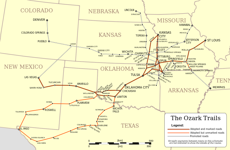
data to properly position all towns and cities on a projected map of the pertinent states. As no information or data was found concerning the lay of the roads, they are represented as straight lines between the contected towns. Thus this map retains an element of a schematic insofar as details of
849:
819:
789:
198:
which appears as though it may have been taken from a guide book published by the Ozark Trails
Association, the body which organized the establishment of the network. Unlike that map, which is a schematic diagram much like a modern subway map, the creation of this map employed
759:
314:– You must give appropriate credit, provide a link to the license, and indicate if changes were made. You may do so in any reasonable manner, but not in any way that suggests the licensor endorses you or your use.
210:
centered on the meridian at 95.15° west longitude. The properties of this projection are such that scale is constant along all parallels and along the central meridian.
370:
68:
64:
60:
56:
52:
48:
42:
105:
77:
368:; with no Invariant Sections, no Front-Cover Texts, and no Back-Cover Texts. A copy of the license is included in the section entitled
360:
157:
776:
Found and elliminated the stray objects showing up in wikimedia & firefox but not in inkscape; added background color object.
670:
600:
583:
547:
200:
321:
848:
843:
818:
813:
788:
783:
690:
654:
531:
503:
488:
475:
365:
620:
567:
448:
431:
189:
149:
888:
867:
185:
283:
495:
320:– If you remix, transform, or build upon the material, you must distribute your contributions under the
207:
161:
280:
836:
The background color of the map did not reproduce properly, so it has been added as a bottom layer
893:
758:
753:
181:
113:
37:
347:
358:
Permission is granted to copy, distribute and/or modify this document under the terms of the
510:
177:
255:
I, the copyright holder of this work, hereby publish it under the following licenses:
100:
165:
153:
859:
829:
799:
769:
176:. Parts of the Ozark Trails road network were predecessor segments of historic
219:
871:
195:
173:
169:
806:
Reverted to version as of 05:09, 25 April 2009; didn't fix the problem
239:
156:
in the early part of the twentieth century prior to the creation of the
870:
network of automobile roads established by local groups across several
152:
network of automobile roads established by local groups across several
194:
The information for this map was taken from an undated map found at
726:
Click on a date/time to view the file as it appeared at that time.
866:{{Information |Description={{en|1=This is a schematic map of the
204:
the overland routes between towns and cities are not presented.
88:
82:(SVG file, nominally 1,414 × 922 pixels, file size: 441 KB)
415:
Add a one-line explanation of what this file represents
180:, which was an important cross-country route between
911:
601:
Creative
Commons Attribution-ShareAlike 3.0 Unported
584:
364:, Version 1.2 or any later version published by the
132:
112:
Commons is a freely licensed media file repository.
160:The network adopted local roads stretching from
331:https://creativecommons.org/licenses/by-sa/3.0
93:
337:Creative Commons Attribution-Share Alike 3.0
261:
8:
168:, with other associated roads reaching into
297:– to copy, distribute and transmit the work
196:http://www.drivetheost.com/ozarktrails.html
41:Size of this PNG preview of this SVG file:
874:in the early part of the twentieth century
728:
411:
396:You may select the license of your choice.
904:The following other wikis use this file:
511:http://commons.wikimedia.org/User:Kbh3rd
886:
704:
688:
668:
652:
634:
618:
598:
581:
565:
545:
529:
462:
446:
429:
426:
407:
400:
884:The following 2 pages use this file:
7:
376:http://www.gnu.org/copyleft/fdl.html
284:Attribution-Share Alike 3.0 Unported
206:This map is presented with a custom
717:
272:
267:
420:
414:
395:
258:
254:
142:
125:
75:
419:
158:national numbered highway system.
405:
352:
351:
308:Under the following conditions:
279:This file is licensed under the
271:
266:
260:
92:
31:
21:
402:
148:This is a schematic map of the
143:
138:Ozark Trails road schematic.svg
14:
401:
382:GNU Free Documentation License
371:GNU Free Documentation License
361:GNU Free Documentation License
26:
1:
671:original creation by uploader
427:Items portrayed in this file
188:prior to the advent of the
930:
908:Usage on www.wikidata.org
322:same or compatible license
718:
229:
190:Interstate Highway System
16:
889:Ozark Trail (auto trail)
404:
366:Free Software Foundation
288:
99:This is a file from the
865:
835:
805:
775:
235:
225:
218:
215:
135:
103:. Information from its
106:description page there
844:05:09, 25 April 2009
814:05:23, 25 April 2009
784:05:31, 25 April 2009
754:18:04, 25 April 2009
208:polyconic projection
65:2,560 × 1,669 pixels
303:– to adapt the work
162:St. Louis, Missouri
47:Other resolutions:
894:User:Kbh3rd/Images
489:Wikimedia username
476:author name string
69:1,414 × 922 pixels
61:1,280 × 835 pixels
57:1,024 × 668 pixels
900:Global file usage
877:
568:copyright license
413:
393:
392:
245:
244:
121:
120:
101:Wikimedia Commons
32:Global file usage
921:
856:
826:
796:
766:
532:copyright status
513:
508:
498:
493:
483:
480:
389:
386:
383:
380:
377:
355:
354:
348:
344:
341:
338:
335:
332:
324:as the original.
281:Creative Commons
275:
274:
270:
269:
264:
263:
231:
221:
147:
139:
133:
117:
96:
95:
89:
83:
72:
53:640 × 417 pixels
49:320 × 209 pixels
43:800 × 522 pixels
929:
928:
924:
923:
922:
920:
919:
918:
898:
878:
862:
854:
832:
824:
802:
794:
772:
764:
720:
719:
716:
715:
714:
713:
712:
711:
710:
709:
707:
697:
696:
695:
693:
682:
681:
680:
679:
678:
677:
676:
675:
673:
661:
660:
659:
657:
646:
645:
644:
643:
642:
641:
640:
639:
637:
627:
626:
625:
623:
612:
611:
610:
609:
608:
607:
606:
605:
603:
592:
591:
590:
589:
588:
586:
574:
573:
572:
570:
559:
558:
557:
556:
555:
554:
553:
552:
550:
538:
537:
536:
534:
523:
522:
521:
520:
519:
518:
517:
516:
515:
514:
509:
506:
500:
499:
494:
491:
485:
484:
481:
478:
469:
468:
467:
465:
455:
454:
453:
451:
440:
439:
438:
437:
436:
434:
418:
417:
416:
399:
398:
397:
387:
384:
381:
378:
375:
346:
345:
342:
339:
336:
333:
330:
329:
287:
276:
257:
256:
251:
246:
211:
137:
130:
123:
122:
111:
110:
109:is shown below.
85:
81:
74:
73:
46:
12:
11:
5:
927:
925:
917:
916:
915:
914:
902:
901:
897:
896:
891:
882:
881:
876:
875:
864:
860:
857:
851:
846:
841:
838:
837:
834:
830:
827:
821:
816:
811:
808:
807:
804:
800:
797:
791:
786:
781:
778:
777:
774:
770:
767:
761:
756:
751:
747:
746:
743:
740:
737:
734:
731:
724:
723:
708:
705:
703:
702:
701:
700:
699:
698:
694:
689:
687:
686:
685:
684:
683:
674:
669:
667:
666:
665:
664:
663:
662:
658:
655:source of file
653:
651:
650:
649:
648:
647:
638:
635:
633:
632:
631:
630:
629:
628:
624:
619:
617:
616:
615:
614:
613:
604:
599:
597:
596:
595:
594:
593:
587:
582:
580:
579:
578:
577:
576:
575:
571:
566:
564:
563:
562:
561:
560:
551:
546:
544:
543:
542:
541:
540:
539:
535:
530:
528:
527:
526:
525:
524:
502:
501:
487:
486:
474:
473:
472:
471:
470:
466:
463:
461:
460:
459:
458:
457:
456:
452:
447:
445:
444:
443:
442:
441:
435:
430:
428:
425:
424:
423:
422:
421:
410:
409:
406:
403:
394:
391:
390:
356:
328:
327:
326:
325:
315:
306:
305:
304:
298:
291:You are free:
278:
277:
259:
253:
252:
250:
247:
243:
242:
237:
233:
232:
227:
223:
222:
217:
213:
212:
140:
131:
129:
126:
124:
119:
118:
97:
87:
86:
40:
36:
35:
34:
29:
24:
19:
13:
10:
9:
6:
4:
3:
2:
926:
913:
910:
909:
907:
906:
905:
899:
895:
892:
890:
887:
885:
879:
873:
869:
863:
858:
852:
850:
847:
845:
842:
840:
839:
833:
828:
822:
820:
817:
815:
812:
810:
809:
803:
798:
792:
790:
787:
785:
782:
780:
779:
773:
768:
762:
760:
757:
755:
752:
749:
748:
744:
741:
738:
735:
732:
730:
729:
727:
721:
706:image/svg+xml
692:
672:
656:
636:24 April 2009
622:
602:
585:
569:
549:
533:
512:
505:
497:
490:
477:
450:
433:
373:
372:
367:
363:
362:
357:
350:
349:
334:CC BY-SA 3.0
323:
319:
316:
313:
310:
309:
307:
302:
299:
296:
293:
292:
290:
289:
285:
282:
265:
248:
241:
238:
234:
228:
224:
220:24 April 2009
214:
209:
205:
202:
197:
191:
187:
183:
179:
175:
171:
167:
163:
159:
155:
151:
146:
141:
134:
127:
115:
108:
107:
102:
98:
91:
90:
84:
79:
78:Original file
70:
66:
62:
58:
54:
50:
44:
39:
33:
30:
28:
25:
23:
20:
18:
15:
903:
883:
868:Ozark Trails
853:1,414 × 922
823:1,414 × 922
793:1,414 × 922
763:1,414 × 922
725:
722:File history
369:
359:
317:
311:
300:
294:
193:
150:Ozark Trails
144:
114:You can help
104:
76:
22:File history
872:U.S. states
548:copyrighted
318:share alike
312:attribution
186:Los Angeles
154:U.S. states
136:Description
880:File usage
739:Dimensions
691:media type
464:some value
166:New Mexico
27:File usage
736:Thumbnail
733:Date/Time
621:inception
249:Licensing
145:English:
855:(443 KB)
825:(443 KB)
795:(443 KB)
765:(441 KB)
408:Captions
301:to remix
295:to share
286:license.
230:Own work
178:Route 66
174:Colorado
170:Nebraska
912:Q819244
750:current
745:Comment
449:creator
432:depicts
412:English
182:Chicago
128:Summary
80:
861:Kbh3rd
831:Kbh3rd
801:Kbh3rd
771:Kbh3rd
496:Kbh3rd
482:Kbh3rd
240:Kbh3rd
236:Author
226:Source
164:into
742:User
388:true
385:true
379:GFDL
343:true
340:true
216:Date
184:and
172:and
17:File
504:URL
201:GIS
507::
492::
479::
192:.
67:|
63:|
59:|
55:|
51:|
45:.
374:.
116:.
71:.
Text is available under the Creative Commons Attribution-ShareAlike License. Additional terms may apply.
