207:
404:
337:
287:
188:
329:
279:
351:
301:
372:
410:
415:
982:
72:
880:"}},"text\/plain":{"en":{"":"heading"}}},"{\"value\":{\"amount\":\"+270\",\"unit\":\"http:\\\/\\\/www.wikidata.org\\\/entity\\\/Q28390\"},\"type\":\"quantity\"}":{"text\/html":{"en":{"P7787":"270
695:"}},"text\/plain":{"en":{"":"heading"}}},"{\"value\":{\"amount\":\"+270\",\"unit\":\"http:\\\/\\\/www.wikidata.org\\\/entity\\\/Q28390\"},\"type\":\"quantity\"}":{"text\/html":{"en":{"P7787":"270
876:
43:
270:
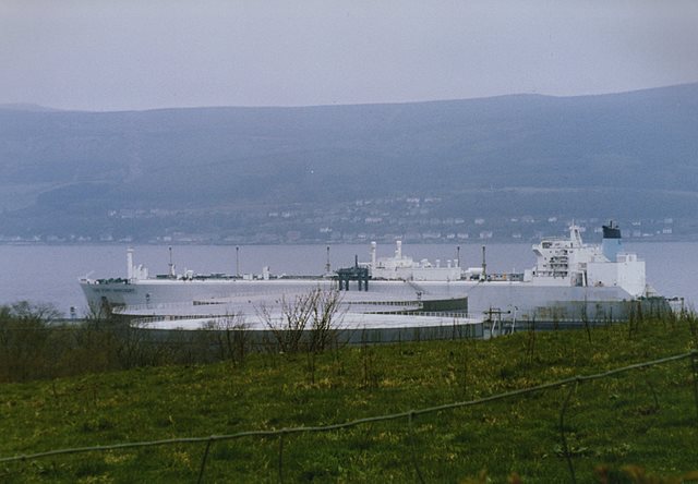
999:== {{int:filedesc}} == {{Information |description={{en|1=LNG Port Harcourt at Inverkip Power Station jetty A scanned image of the steam powered Liquefied Natural Gas tanker "LNG Port Harcourt" at the jetty, viewed from Finnockbog Road.
This is a rare
128:
This is a rare sight indeed; not only was
Inverkip an oil fired power station (with no need for LNG), but very few ships ever berthed there as the power station was rarely used due to the soaring price of oil and the advent of nuclear power in the early 1970s.
198:
83:
51:
462:– You must give appropriate credit, provide a link to the license, and indicate if changes were made. You may do so in any reasonable manner, but not in any way that suggests the licensor endorses you or your use.
126:
LNG Port
Harcourt at Inverkip Power Station jetty. A scanned image of the steam powered Liquefied Natural Gas tanker "LNG Port Harcourt" at the jetty, viewed from Finnockbog Road.
877:
692:
139:
206:
981:
976:
42:
778:
678:
642:
344:
294:
813:
1083:
379:
1064:
This file contains additional information, probably added from the digital camera or scanner used to create or digitize it.
469:
590:
918:
891:
791:
762:
733:
706:
626:
598:
583:
570:
849:
821:
806:
662:
543:
526:
366:
425:
1067:
If the file has been modified from its original state, some details may not fully reflect the modified file.
468:– If you remix, transform, or build upon the material, you must distribute your contributions under the
386:
on the
Geograph website for the photographer's contact details. The copyright on this image is owned by
1041:
992:
422:
884:"}},"text\/plain":{"en":{"P7787":"270 degree"}}}}": -->
699:"}},"text\/plain":{"en":{"P7787":"270 degree"}}}}": -->
91:
239:
828:
798:
605:
223:
199:
LNG Port
Harcourt at Inverkip Power Station jetty - geograph.org.uk - 1068720 (cropped).jpg
350:
300:
391:
78:
116:
LNG Port
Harcourt at Inverkip Power Station jetty - geograph.org.uk - 1068720.jpg
52:
LNG_Port_Harcourt_at_Inverkip_Power_Station_jetty_-_geograph.org.uk_-_1068720.jpg
1076:
334:
284:
1013:
162:
172:
371:
187:
151:
133:
inspection and reactivation after coming out of storage in Loch
Striven.
383:
949:
Click on a date/time to view the file as it appeared at that time.
1031:
136:
Thanks to Chris Allen and John Porter for the above information.
336:
286:
311:
261:
182:
66:
321:
55° 53′ 50″ N, 4° 53′ 57″ W
271:
55° 53′ 50″ N, 4° 52′ 42″ W
510:
Add a one-line explanation of what this file represents
1051:
1042:
Knowledge:Underprosjekter/Sjøfart/Franske skipsverft
110:
90:
Commons is a freely licensed media file repository.
679:
Creative
Commons Attribution-ShareAlike 2.0 Generic
254:LNG Port Harcourt at Inverkip Power Station jetty
235:LNG Port Harcourt at Inverkip Power Station jetty
56:(640 × 444 pixels, file size: 49 KB, MIME type:
479:https://creativecommons.org/licenses/by-sa/2.0
71:
485:Creative Commons Attribution-Share Alike 2.0
403:
8:
881:
696:
445:– to copy, distribute and transmit the work
1069:
951:
506:
1024:The following other wikis use this file:
829:https://www.geograph.org.uk/photo/1068720
606:https://www.geograph.org.uk/profile/4827
1092:
1081:
1071:
1011:
905:
889:
863:
847:
776:
760:
720:
704:
676:
660:
640:
624:
557:
541:
524:
521:
502:
495:
314:
264:
343:View this and other nearby images on:
293:View this and other nearby images on:
7:
390:and is licensed for reuse under the
1009:The following page uses this file:
940:
426:Attribution-Share Alike 2.0 Generic
414:
409:
394:Attribution-ShareAlike 2.0 license.
1062:
515:
509:
400:
377:
120:
103:
49:
514:
1097:2bcdeefd1bcc0f540a7de9796519112a
707:coordinates of the point of view
500:
456:Under the following conditions:
421:This file is licensed under the
413:
408:
402:
370:
349:
335:
327:
299:
285:
277:
205:
186:
70:
31:
21:
497:
121:
46:No higher resolution available.
14:
779:file available on the internet
496:
378:This image was taken from the
142:can be seen in the foreground.
26:
1:
892:coordinates of depicted place
36:
814:Geograph Britain and Ireland
584:object of statement has role
522:Items portrayed in this file
326:
276:
907:55°53'49.78"N, 4°53'57.12"W
1114:
1048:Usage on www.wikidata.org
1038:Usage on no.wikipedia.org
1028:Usage on nl.wikipedia.org
470:same or compatible license
252:Thomas Nugent /
233:Thomas Nugent /
941:
722:55°53'49.9"N, 4°52'42.2"W
16:
792:geograph.org.uk image ID
499:
436:
77:This is a file from the
998:
977:04:22, 24 February 2011
224:required by the license
185:
178:
168:
157:
150:
147:
113:
81:. Information from its
384:this photograph's page
355:55.897160; -4.899200
305:55.897200; -4.878400
138:The oil storage tanks
84:description page there
1032:Gastor (schip, 1977)
451:– to adapt the work
571:author name string
1101:
1100:
1020:Global file usage
1002:
883:
698:
663:copyright license
508:
399:
398:
382:collection. See
360:
359:
310:
309:
259:
258:
227:
214:
213:
193:This file has an
99:
98:
79:Wikimedia Commons
32:Global file usage
1105:
1070:
989:
929:
928:
923:
831:
826:
822:described at URL
816:
811:
801:
796:
744:
743:
738:
627:copyright status
608:
603:
593:
588:
578:
575:
492:
489:
486:
483:
480:
472:as the original.
434:
423:Creative Commons
417:
416:
412:
411:
406:
405:
392:Creative Commons
380:Geograph project
374:
367:
356:
353:
339:
338:
332:
331:
330:
324:
323:
312:
306:
303:
289:
288:
282:
281:
280:
274:
273:
262:
221:
209:
190:
183:
153:
125:
117:
111:
95:
74:
73:
67:
61:
59:
1113:
1112:
1108:
1107:
1106:
1104:
1103:
1102:
1094:Unique image ID
1058:
1018:
1003:
995:
987:
943:
942:
939:
938:
937:
936:
935:
934:
933:
932:
931:
930:
926:
924:
921:
912:
911:
910:
908:
898:
897:
896:
894:
875:
874:
873:
872:
871:
870:
869:
868:
866:
856:
855:
854:
852:
841:
840:
839:
838:
837:
836:
835:
834:
833:
832:
827:
824:
818:
817:
812:
809:
803:
802:
797:
794:
785:
784:
783:
781:
769:
768:
767:
765:
754:
753:
752:
751:
750:
749:
748:
747:
746:
745:
741:
739:
736:
727:
726:
725:
723:
713:
712:
711:
709:
690:
689:
688:
687:
686:
685:
684:
683:
681:
669:
668:
667:
665:
654:
653:
652:
651:
650:
649:
648:
647:
645:
633:
632:
631:
629:
618:
617:
616:
615:
614:
613:
612:
611:
610:
609:
604:
601:
595:
594:
589:
586:
580:
579:
576:
573:
564:
563:
562:
560:
550:
549:
548:
546:
535:
534:
533:
532:
531:
529:
513:
512:
511:
494:
493:
490:
487:
484:
481:
478:
477:
435:
432:
429:
418:
395:
365:
354:
328:
319:
318:
315:Object location
304:
278:
269:
268:
265:Camera location
260:
249:
242:
230:
210:
195:extracted image
163:geograph.org.uk
143:
115:
108:
101:
100:
89:
88:
87:is shown below.
63:
57:
55:
48:
47:
12:
11:
5:
1111:
1109:
1099:
1098:
1095:
1091:
1090:
1087:
1080:
1079:
1074:
1061:
1057:
1056:
1055:
1054:
1046:
1045:
1044:
1036:
1035:
1034:
1022:
1021:
1017:
1016:
1007:
1006:
1001:
1000:
997:
993:
990:
984:
979:
974:
970:
969:
966:
963:
960:
957:
954:
947:
946:
917:
916:
915:
914:
913:
909:
906:
904:
903:
902:
901:
900:
899:
895:
890:
888:
887:
886:
885:
879:
867:
864:
862:
861:
860:
859:
858:
857:
853:
848:
846:
845:
844:
843:
842:
820:
819:
805:
804:
790:
789:
788:
787:
786:
782:
777:
775:
774:
773:
772:
771:
770:
766:
763:source of file
761:
759:
758:
757:
756:
755:
732:
731:
730:
729:
728:
724:
721:
719:
718:
717:
716:
715:
714:
710:
705:
703:
702:
701:
700:
694:
682:
677:
675:
674:
673:
672:
671:
670:
666:
661:
659:
658:
657:
656:
655:
646:
641:
639:
638:
637:
636:
635:
634:
630:
625:
623:
622:
621:
620:
619:
597:
596:
582:
581:
569:
568:
567:
566:
565:
561:
558:
556:
555:
554:
553:
552:
551:
547:
542:
540:
539:
538:
537:
536:
530:
525:
523:
520:
519:
518:
517:
516:
505:
504:
501:
498:
476:
475:
474:
473:
463:
454:
453:
452:
446:
439:You are free:
430:
420:
419:
401:
397:
396:
375:
364:
361:
358:
357:
347:
341:
316:
308:
307:
297:
291:
266:
257:
256:
250:
247:
244:
243:
238:
231:
228:
216:
215:
212:
211:
204:
202:
191:
180:
179:Other versions
176:
175:
170:
166:
165:
159:
155:
154:
149:
145:
144:
118:
109:
107:
104:
102:
97:
96:
75:
65:
64:
45:
41:
40:
39:
34:
29:
24:
19:
13:
10:
9:
6:
4:
3:
2:
1110:
1096:
1093:
1088:
1085:
1082:
1078:
1075:
1073:Software used
1072:
1068:
1065:
1059:
1053:
1050:
1049:
1047:
1043:
1040:
1039:
1037:
1033:
1030:
1029:
1027:
1026:
1025:
1019:
1015:
1012:
1010:
1004:
996:
991:
985:
983:
980:
978:
975:
972:
971:
967:
964:
961:
958:
955:
953:
952:
950:
944:
920:
893:
851:
830:
823:
815:
808:
800:
793:
780:
764:
735:
708:
680:
664:
644:
628:
607:
600:
592:
585:
577:Thomas Nugent
572:
545:
528:
482:CC BY-SA 2.0
471:
467:
464:
461:
458:
457:
455:
450:
447:
444:
441:
440:
438:
437:
433:Thomas Nugent
431:Attribution:
427:
424:
407:
393:
389:
388:Thomas Nugent
385:
381:
376:
373:
369:
368:
362:
352:
348:
346:
345:OpenStreetMap
342:
340:
322:
317:
313:
302:
298:
296:
295:OpenStreetMap
292:
290:
272:
267:
263:
255:
251:
246:
245:
241:
237: /
236:
232:
225:
220:
218:
217:
208:
203:
200:
196:
192:
189:
184:
181:
177:
174:
173:Thomas Nugent
171:
167:
164:
160:
156:
146:
141:
137:
134:
130:
124:
119:
112:
105:
93:
86:
85:
80:
76:
69:
68:
62:
53:
44:
38:
35:
33:
30:
28:
25:
23:
20:
18:
15:
1066:
1063:
1023:
1008:
948:
945:File history
591:photographer
465:
459:
448:
442:
387:
325:
275:
253:
240:CC BY-SA 2.0
234:
194:
135:
131:
127:
122:
92:You can help
82:
50:
22:File history
994:GeographBot
643:copyrighted
466:share alike
460:attribution
219:Attribution
114:Description
1077:Picasa 3.0
1005:File usage
986:640 × 444
962:Dimensions
559:some value
58:image/jpeg
27:File usage
1014:MV Gastor
959:Thumbnail
956:Date/Time
850:inception
363:Licensing
248:InfoField
229:InfoField
123:English:
1060:Metadata
1052:Q2002062
807:operator
503:Captions
449:to remix
443:to share
428:license.
37:Metadata
1086:version
988:(49 KB)
973:current
968:Comment
919:heading
878:heading
799:1068720
734:heading
693:heading
544:creator
527:depicts
507:English
106:Summary
54:
927:degree
882:degree
742:degree
697:degree
333:
283:
169:Author
158:Source
140:535990
161:From
1084:Exif
965:User
925:270
865:1988
740:270
491:true
488:true
152:1988
148:Date
17:File
1089:2.1
599:URL
922::
825::
810::
795::
737::
602::
587::
574::
197::
226:)
222:(
201:.
94:.
60:)
Text is available under the Creative Commons Attribution-ShareAlike License. Additional terms may apply.
.jpg)
_heading:270.00&language=en)
_heading:270.00&language=en)
