363:
296:
246:
288:
238:
310:
260:
331:
369:
43:
374:
87:
839:"}},"text\/plain":{"en":{"":"heading"}}},"{\"value\":{\"amount\":\"+180\",\"unit\":\"http:\\\/\\\/www.wikidata.org\\\/entity\\\/Q28390\"},\"type\":\"quantity\"}":{"text\/html":{"en":{"P7787":"180
775:"}},"text\/plain":{"en":{"":"heading"}}},"{\"value\":{\"amount\":\"+180\",\"unit\":\"http:\\\/\\\/www.wikidata.org\\\/entity\\\/Q28390\"},\"type\":\"quantity\"}":{"text\/html":{"en":{"P7787":"180
835:
279:
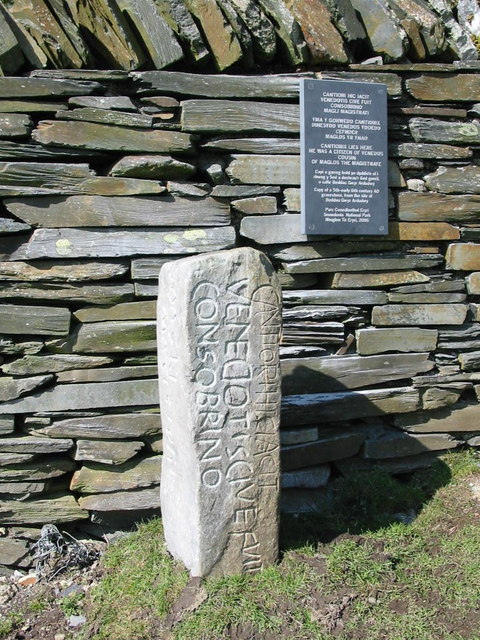
958:== {{int:filedesc}} == {{Information |description={{en|1=Latin inscription This stone has recently appeared by the Ffestiniog waterworks wall. As the slate inscription explains it is a copy. The original is in Penmachno church.}} |date=2007-03-24 |sourc
229:
421:– You must give appropriate credit, provide a link to the license, and indicate if changes were made. You may do so in any reasonable manner, but not in any way that suggests the licensor endorses you or your use.
53:
47:
98:
141:
Latin inscription This stone has recently appeared by the
Ffestiniog waterworks wall. As the slate inscription explains it is a copy. The original is in Penmachno church.
66:
836:
772:
673:
637:
601:
303:
253:
708:
1091:
338:
1003:
This file contains additional information, probably added from the digital camera or scanner used to create or digitize it.
428:
564:
877:
850:
813:
786:
716:
657:
585:
557:
544:
529:
744:
701:
686:
621:
502:
485:
940:
935:
325:
57:
42:
384:
1006:
If the file has been modified from its original state, some details may not fully reflect the modified file.
968:
The following pages on the
English Knowledge (XXG) use this file (pages on other projects are not listed):
1128:
972:
427:– If you remix, transform, or build upon the material, you must distribute your contributions under the
345:
on the
Geograph website for the photographer's contact details. The copyright on this image is owned by
951:
381:
843:"}},"text\/plain":{"en":{"P7787":"180 degree"}}}}": -->
779:"}},"text\/plain":{"en":{"P7787":"180 degree"}}}}": -->
1025:
106:
198:
723:
693:
536:
182:
1015:
309:
259:
1110:
350:
93:
1041:
1138:
150:
293:
243:
171:
161:
330:
342:
908:
Click on a date/time to view the file as it appeared at that time.
990:
295:
245:
270:
220:
81:
280:
52° 58′ 01″ N, 3° 53′ 56″ W
230:
52° 58′ 01″ N, 3° 53′ 56″ W
469:
Add a one-line explanation of what this file represents
125:
105:
Commons is a freely licensed media file repository.
638:
Creative
Commons Attribution-ShareAlike 2.0 Generic
71:(480 × 640 pixels, file size: 138 KB, MIME type:
131:Latin inscription - geograph.org.uk - 376760.jpg
438:https://creativecommons.org/licenses/by-sa/2.0
86:
444:Creative Commons Attribution-Share Alike 2.0
362:
8:
840:
776:
404:– to copy, distribute and transmit the work
1008:
910:
465:
983:The following other wikis use this file:
694:https://www.geograph.org.uk/photo/376760
537:https://www.geograph.org.uk/profile/6190
1162:
1154:
1146:
1136:
1126:
1118:
1108:
1100:
1089:
1081:
1073:
1065:
1057:
1049:
1038:
1030:
1020:
970:
864:
848:
800:
784:
758:
742:
671:
655:
635:
619:
599:
583:
516:
500:
483:
480:
461:
454:
273:
223:
302:View this and other nearby images on:
252:View this and other nearby images on:
1010:
7:
349:and is licensed for reuse under the
899:
385:Attribution-Share Alike 2.0 Generic
373:
368:
353:Attribution-ShareAlike 2.0 license.
1001:
474:
468:
359:
336:
135:
118:
64:
473:
1032:Date and time of data generation
787:coordinates of the point of view
459:
415:Under the following conditions:
380:This file is licensed under the
372:
367:
361:
329:
308:
294:
286:
258:
244:
236:
85:
31:
21:
456:
136:
14:
674:file available on the internet
455:
337:This image was taken from the
26:
1:
851:coordinates of depicted place
36:
709:Geograph Britain and Ireland
558:object of statement has role
481:Items portrayed in this file
285:
235:
1164:Focal plane resolution unit
1102:Date and time of digitizing
1184:
987:Usage on la.wikipedia.org
429:same or compatible license
1075:File change date and time
900:
16:
1156:Focal plane Y resolution
1148:Focal plane X resolution
866:52°58'0.8"N, 3°53'56.4"W
802:52°58'0.8"N, 3°53'56.4"W
717:geograph.org.uk image ID
458:
395:
92:This is a file from the
957:
183:required by the license
167:
156:
149:
146:
128:
96:. Information from its
343:this photograph's page
314:52.966900; -3.899000
264:52.966900; -3.899000
99:description page there
46:Size of this preview:
1059:Horizontal resolution
973:Cantiorix Inscription
936:20:54, 4 January 2011
1105:13:56, 24 March 2007
1078:13:56, 24 March 2007
1035:13:56, 24 March 2007
1083:Y and C positioning
1067:Vertical resolution
1026:Canon PowerShot A20
1012:Camera manufacturer
991:Inscriptio Cantiori
410:– to adapt the work
52:Other resolutions:
545:author name string
1171:
1170:
979:Global file usage
961:
842:
778:
622:copyright license
467:
358:
357:
341:collection. See
319:
318:
269:
268:
218:
217:
213:Latin inscription
211:Dewi /
194:Latin inscription
192:Dewi /
186:
114:
113:
94:Wikimedia Commons
32:Global file usage
1175:
1159:4,970.8737864078
1151:4,954.8387096774
1009:
948:
888:
887:
882:
824:
823:
818:
726:
721:
711:
706:
696:
691:
687:described at URL
586:copyright status
567:
562:
552:
549:
539:
534:
451:
448:
445:
442:
439:
431:as the original.
393:
382:Creative Commons
376:
375:
371:
370:
365:
364:
351:Creative Commons
339:Geograph project
333:
326:
315:
312:
298:
297:
291:
290:
289:
283:
282:
271:
265:
262:
248:
247:
241:
240:
239:
233:
232:
221:
180:
152:
140:
132:
126:
110:
89:
88:
82:
76:
74:
61:
58:480 × 640 pixels
54:180 × 240 pixels
48:450 × 600 pixels
1183:
1182:
1178:
1177:
1176:
1174:
1173:
1172:
997:
977:
969:
962:
954:
946:
902:
901:
898:
897:
896:
895:
894:
893:
892:
891:
890:
889:
885:
883:
880:
871:
870:
869:
867:
857:
856:
855:
853:
834:
833:
832:
831:
830:
829:
828:
827:
826:
825:
821:
819:
816:
807:
806:
805:
803:
793:
792:
791:
789:
770:
769:
768:
767:
766:
765:
764:
763:
761:
751:
750:
749:
747:
736:
735:
734:
733:
732:
731:
730:
729:
728:
727:
722:
719:
713:
712:
707:
704:
698:
697:
692:
689:
680:
679:
678:
676:
664:
663:
662:
660:
649:
648:
647:
646:
645:
644:
643:
642:
640:
628:
627:
626:
624:
613:
612:
611:
610:
609:
608:
607:
606:
604:
592:
591:
590:
588:
577:
576:
575:
574:
573:
572:
571:
570:
569:
568:
563:
560:
554:
553:
550:
547:
541:
540:
535:
532:
523:
522:
521:
519:
509:
508:
507:
505:
494:
493:
492:
491:
490:
488:
472:
471:
470:
453:
452:
449:
446:
443:
440:
437:
436:
394:
391:
388:
377:
354:
324:
313:
287:
278:
277:
274:Object location
263:
237:
228:
227:
224:Camera location
219:
208:
201:
189:
162:geograph.org.uk
142:
130:
123:
116:
115:
104:
103:
102:is shown below.
78:
72:
70:
63:
62:
51:
12:
11:
5:
1181:
1179:
1169:
1168:
1165:
1161:
1160:
1157:
1153:
1152:
1149:
1145:
1144:
1141:
1135:
1134:
1131:
1125:
1124:
1121:
1117:
1116:
1113:
1107:
1106:
1103:
1099:
1098:
1095:
1088:
1087:
1084:
1080:
1079:
1076:
1072:
1071:
1068:
1064:
1063:
1060:
1056:
1055:
1052:
1048:
1047:
1044:
1037:
1036:
1033:
1029:
1028:
1023:
1019:
1018:
1013:
1000:
996:
995:
994:
993:
981:
980:
976:
975:
967:
966:
965:
960:
959:
956:
952:
949:
943:
938:
933:
929:
928:
925:
922:
919:
916:
913:
906:
905:
876:
875:
874:
873:
872:
868:
865:
863:
862:
861:
860:
859:
858:
854:
849:
847:
846:
845:
844:
838:
812:
811:
810:
809:
808:
804:
801:
799:
798:
797:
796:
795:
794:
790:
785:
783:
782:
781:
780:
774:
762:
759:
757:
756:
755:
754:
753:
752:
748:
743:
741:
740:
739:
738:
737:
715:
714:
700:
699:
685:
684:
683:
682:
681:
677:
672:
670:
669:
668:
667:
666:
665:
661:
658:source of file
656:
654:
653:
652:
651:
650:
641:
636:
634:
633:
632:
631:
630:
629:
625:
620:
618:
617:
616:
615:
614:
605:
600:
598:
597:
596:
595:
594:
593:
589:
584:
582:
581:
580:
579:
578:
556:
555:
543:
542:
528:
527:
526:
525:
524:
520:
517:
515:
514:
513:
512:
511:
510:
506:
501:
499:
498:
497:
496:
495:
489:
484:
482:
479:
478:
477:
476:
475:
464:
463:
460:
457:
435:
434:
433:
432:
422:
413:
412:
411:
405:
398:You are free:
389:
379:
378:
360:
356:
355:
334:
323:
320:
317:
316:
306:
300:
275:
267:
266:
256:
250:
225:
216:
215:
209:
206:
203:
202:
197:
190:
187:
175:
174:
169:
165:
164:
158:
154:
153:
148:
144:
143:
133:
124:
122:
119:
117:
112:
111:
90:
80:
79:
45:
41:
40:
39:
34:
29:
24:
19:
13:
10:
9:
6:
4:
3:
2:
1180:
1166:
1163:
1158:
1155:
1150:
1147:
1142:
1140:
1137:
1132:
1130:
1129:Exposure bias
1127:
1122:
1120:APEX aperture
1119:
1114:
1112:
1111:Shutter speed
1109:
1104:
1101:
1096:
1093:
1090:
1085:
1082:
1077:
1074:
1069:
1066:
1061:
1058:
1053:
1050:
1045:
1043:
1039:
1034:
1031:
1027:
1024:
1021:
1017:
1014:
1011:
1007:
1004:
998:
992:
989:
988:
986:
985:
984:
978:
974:
971:
963:
955:
950:
944:
942:
939:
937:
934:
931:
930:
926:
923:
920:
917:
914:
912:
911:
909:
903:
879:
852:
815:
788:
760:24 March 2007
746:
725:
718:
710:
703:
695:
688:
675:
659:
639:
623:
603:
587:
566:
559:
546:
538:
531:
504:
487:
441:CC BY-SA 2.0
430:
426:
423:
420:
417:
416:
414:
409:
406:
403:
400:
399:
397:
396:
390:Attribution:
386:
383:
366:
352:
348:
344:
340:
335:
332:
328:
327:
321:
311:
307:
305:
304:OpenStreetMap
301:
299:
281:
276:
272:
261:
257:
255:
254:OpenStreetMap
251:
249:
231:
226:
222:
214:
210:
205:
204:
200:
196: /
195:
191:
184:
179:
177:
176:
173:
170:
166:
163:
159:
155:
151:24 March 2007
145:
139:
134:
127:
120:
108:
101:
100:
95:
91:
84:
83:
77:
68:
67:Original file
59:
55:
49:
44:
38:
35:
33:
30:
28:
25:
23:
20:
18:
15:
1042:focal length
1022:Camera model
1005:
1002:
982:
907:
904:File history
565:photographer
424:
418:
407:
401:
346:
284:
234:
212:
199:CC BY-SA 2.0
193:
137:
107:You can help
97:
65:
22:File history
1139:Color space
1051:Orientation
953:GeographBot
602:copyrighted
425:share alike
419:attribution
178:Attribution
129:Description
1046:7.84375 mm
964:File usage
945:480 × 640
921:Dimensions
518:some value
73:image/jpeg
27:File usage
918:Thumbnail
915:Date/Time
745:inception
322:Licensing
207:InfoField
188:InfoField
138:English:
1086:Centered
999:Metadata
947:(138 KB)
702:operator
462:Captions
408:to remix
402:to share
387:license.
37:Metadata
1123:6.34375
1115:6.96875
1094:version
1070:180 dpi
1062:180 dpi
932:current
927:Comment
878:heading
837:heading
814:heading
773:heading
503:creator
486:depicts
466:English
121:Summary
69:
1167:inches
1054:Normal
886:degree
841:degree
822:degree
777:degree
724:376760
292:
242:
168:Author
157:Source
1040:Lens
1016:Canon
160:From
1143:sRGB
1092:Exif
924:User
884:180
820:180
551:Dewi
450:true
447:true
392:Dewi
347:Dewi
172:Dewi
147:Date
17:File
530:URL
881::
817::
720::
705::
690::
561::
548::
533::
56:|
50:.
1133:0
1097:2
185:)
181:(
109:.
75:)
60:.
Text is available under the Creative Commons Attribution-ShareAlike License. Additional terms may apply.
_heading:180.00&language=en)
_heading:180.00&language=en)
