43:
259:
220:
212:
234:
265:
270:
99:
666:"}},"text\/plain":{"en":{"":"heading"}}},"{\"value\":{\"amount\":\"+264.5\",\"unit\":\"http:\\\/\\\/www.wikidata.org\\\/entity\\\/Q28390\"},\"type\":\"quantity\"}":{"text\/html":{"en":{"P7787":"264.5
662:
203:
311:– You must give appropriate credit, provide a link to the license, and indicate if changes were made. You may do so in any reasonable manner, but not in any way that suggests the licensor endorses you or your use.
663:
65:
61:
57:
53:
47:
110:
78:
816:
649:
613:
543:
507:
227:
974:
839:
This file contains additional information, probably added from the digital camera or scanner used to create or digitize it.
318:
427:
704:
677:
633:
597:
491:
463:
448:
435:
420:
563:
527:
393:
376:
455:
280:
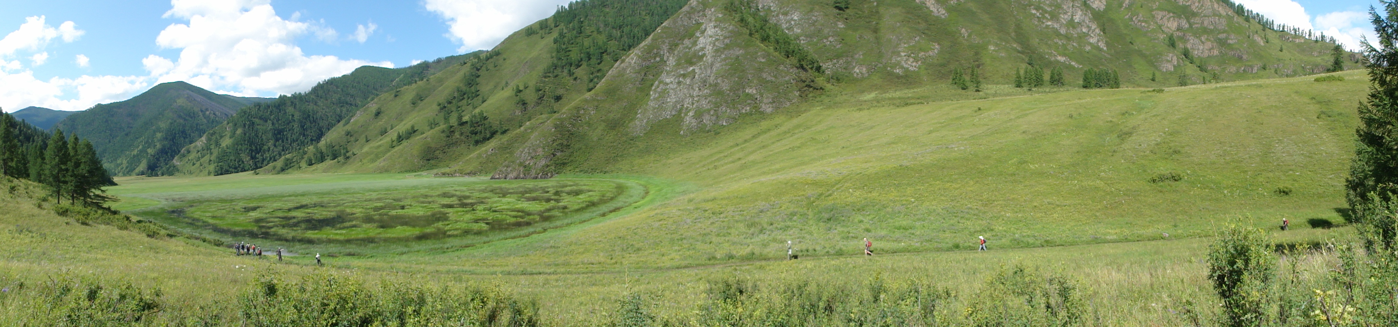
157:. The floodway along the Katun river is running behind the bar, parallel to it, and in the sense of this view.
842:
If the file has been modified from its original state, some details may not fully reflect the modified file.
794:
The following pages on the
English Knowledge (XXG) use this file (pages on other projects are not listed):
826:
1022:
317:– If you remix, transform, or build upon the material, you must distribute your contributions under the
670:"}},"text\/plain":{"en":{"P7787":"264.5 degree"}}}}": -->
277:
1058:
767:
762:
69:
42:
118:
470:
1152:
778:
233:
1134:
1040:
868:
105:
252:
I, the copyright holder of this work, hereby publish it under the following license:
1162:
908:
154:
217:
186:
1092:
798:
166:
888:
1172:
878:
861:
735:
Click on a date/time to view the file as it appeared at that time.
153:
Lake (left) formed behind gravel bar (right) deposited during the
851:
219:
204:
50° 19′ 30.09″ N, 87° 03′ 30.66″ E
194:
93:
360:
Add a one-line explanation of what this file represents
83:(4,611 × 1,080 pixels, file size: 1.77 MB, MIME type:
544:
Creative
Commons Attribution-ShareAlike 3.0 Unported
137:
117:
Commons is a freely licensed media file repository.
1063:Flash did not fire, compulsory flash suppression
328:https://creativecommons.org/licenses/by-sa/3.0
98:
334:Creative Commons Attribution-Share Alike 3.0
258:
8:
667:
471:http://commons.wikimedia.org/User:Gaianauta
294:– to copy, distribute and transmit the work
844:
737:
356:
809:The following other wikis use this file:
1276:
1268:
1260:
1252:
1244:
1236:
1228:
1220:
1212:
1204:
1196:
1188:
1180:
1170:
1160:
1150:
1142:
1132:
1124:
1116:
1108:
1100:
1090:
1082:
1074:
1066:
1056:
1048:
1038:
1030:
1020:
1012:
991:
983:
972:
964:
956:
948:
940:
932:
924:
916:
905:
897:
886:
876:
866:
856:
796:
691:
675:
647:
631:
611:
595:
577:
561:
541:
525:
505:
489:
407:
391:
374:
371:
352:
345:
197:
226:View this and other nearby images on:
846:
7:
281:Attribution-Share Alike 3.0 Unported
1222:Reference for direction of movement
726:
269:
264:
837:
365:
359:
255:
251:
147:
130:
76:
364:
143:Lake formed behind gravel bar.jpg
1238:Reference for direction of image
899:Date and time of data generation
827:Thành viên:Phương Huy/Phong cảnh
678:coordinates of the point of view
350:
305:Under the following conditions:
276:This file is licensed under the
268:
263:
257:
232:
218:
210:
97:
31:
21:
347:
148:
14:
937:1,134.5 meters above sea level
346:
209:
26:
1:
1113:A directly photographed image
693:50°19'30.090"N, 87°3'30.658"E
650:original creation by uploader
36:
1076:DateTimeDigitized subseconds
421:object of statement has role
372:Items portrayed in this file
1270:GPS differential correction
1068:DateTimeOriginal subseconds
985:Date and time of digitizing
1298:
1084:Supported Flashpix version
823:Usage on vi.wikipedia.org
813:Usage on uk.wikipedia.org
319:same or compatible license
1254:Geodetic survey data used
1201:3-dimensional measurement
993:Meaning of each component
950:File change date and time
727:
176:
16:
614:Sony Cyber-shot DSC-HX5V
349:
285:
104:This is a file from the
1193:Measurement in progress
1182:GPS time (atomic clock)
1118:Custom image processing
784:
182:
172:
165:
162:
140:
108:. Information from its
1014:Image compression mode
763:20:58, 12 October 2011
238:50.325025; 87.058516
111:description page there
46:Size of this preview:
1230:Direction of movement
1214:Speed of GPS receiver
1032:Maximum land aperture
873:1/640 sec (0.0015625)
1105:Digital still camera
988:05:51, 3 August 2010
953:05:51, 3 August 2010
902:05:51, 3 August 2010
70:4,611 × 1,080 pixels
1209:Kilometers per hour
1035:3.625 APEX (f/3.51)
958:Y and C positioning
848:Camera manufacturer
300:– to adapt the work
52:Other resolutions:
1246:Direction of image
1241:Magnetic direction
1144:Scene capture type
1139:Auto white balance
449:Wikimedia username
436:author name string
66:1,280 × 300 pixels
62:1,024 × 240 pixels
1285:
1284:
805:Global file usage
787:
669:
528:copyright license
358:
243:
242:
192:
191:
126:
125:
106:Wikimedia Commons
32:Global file usage
1289:
1198:Measurement mode
966:Exposure Program
921:50° 19′ 30.09″ N
845:
817:Алтайський потоп
775:
715:
714:
709:
492:copyright status
473:
468:
458:
453:
443:
440:
430:
425:
341:
338:
335:
332:
329:
321:as the original.
278:Creative Commons
272:
271:
267:
266:
261:
260:
239:
236:
222:
221:
215:
214:
213:
207:
206:
195:
178:
168:
152:
144:
138:
122:
101:
100:
94:
88:
86:
73:
58:640 × 150 pixels
48:799 × 187 pixels
1297:
1296:
1292:
1291:
1290:
1288:
1287:
1286:
1278:GPS tag version
1190:Receiver status
929:87° 3′ 30.66″ E
833:
803:
795:
788:
781:
773:
729:
728:
725:
724:
723:
722:
721:
720:
719:
718:
717:
716:
712:
710:
707:
698:
697:
696:
694:
684:
683:
682:
680:
661:
660:
659:
658:
657:
656:
655:
654:
652:
640:
639:
638:
636:
625:
624:
623:
622:
621:
620:
619:
618:
616:
604:
603:
602:
600:
589:
588:
587:
586:
585:
584:
583:
582:
580:
570:
569:
568:
566:
555:
554:
553:
552:
551:
550:
549:
548:
546:
534:
533:
532:
530:
519:
518:
517:
516:
515:
514:
513:
512:
510:
498:
497:
496:
494:
483:
482:
481:
480:
479:
478:
477:
476:
475:
474:
469:
466:
460:
459:
454:
451:
445:
444:
441:
438:
432:
431:
426:
423:
414:
413:
412:
410:
400:
399:
398:
396:
385:
384:
383:
382:
381:
379:
363:
362:
361:
344:
343:
342:
339:
336:
333:
330:
327:
326:
284:
273:
254:
253:
248:
237:
211:
202:
201:
198:Camera location
193:
158:
142:
135:
128:
127:
116:
115:
114:is shown below.
90:
84:
82:
75:
74:
54:320 × 75 pixels
51:
12:
11:
5:
1295:
1293:
1283:
1282:
1279:
1275:
1274:
1271:
1267:
1266:
1263:
1259:
1258:
1255:
1251:
1250:
1247:
1243:
1242:
1239:
1235:
1234:
1231:
1227:
1226:
1225:True direction
1223:
1219:
1218:
1215:
1211:
1210:
1207:
1203:
1202:
1199:
1195:
1194:
1191:
1187:
1186:
1183:
1179:
1178:
1175:
1169:
1168:
1165:
1159:
1158:
1155:
1149:
1148:
1145:
1141:
1140:
1137:
1131:
1130:
1127:
1123:
1122:
1121:Normal process
1119:
1115:
1114:
1111:
1107:
1106:
1103:
1099:
1098:
1095:
1089:
1088:
1085:
1081:
1080:
1077:
1073:
1072:
1069:
1065:
1064:
1061:
1055:
1054:
1051:
1047:
1046:
1043:
1037:
1036:
1033:
1029:
1028:
1025:
1019:
1018:
1015:
1011:
1010:
1009:
1008:
1007:does not exist
1005:
1002:
999:
994:
990:
989:
986:
982:
981:
978:
971:
970:
969:Normal program
967:
963:
962:
959:
955:
954:
951:
947:
946:
943:
939:
938:
935:
931:
930:
927:
923:
922:
919:
915:
914:
911:
904:
903:
900:
896:
895:
892:
885:
884:
881:
875:
874:
871:
865:
864:
859:
855:
854:
849:
836:
832:
831:
830:
829:
821:
820:
819:
807:
806:
802:
801:
793:
792:
791:
786:
785:
783:
779:
776:
772:4,611 × 1,080
770:
765:
760:
756:
755:
752:
749:
746:
743:
740:
733:
732:
703:
702:
701:
700:
699:
695:
692:
690:
689:
688:
687:
686:
685:
681:
676:
674:
673:
672:
671:
665:
653:
648:
646:
645:
644:
643:
642:
641:
637:
634:source of file
632:
630:
629:
628:
627:
626:
617:
612:
610:
609:
608:
607:
606:
605:
601:
596:
594:
593:
592:
591:
590:
581:
578:
576:
575:
574:
573:
572:
571:
567:
562:
560:
559:
558:
557:
556:
547:
542:
540:
539:
538:
537:
536:
535:
531:
526:
524:
523:
522:
521:
520:
511:
506:
504:
503:
502:
501:
500:
499:
495:
490:
488:
487:
486:
485:
484:
462:
461:
447:
446:
434:
433:
419:
418:
417:
416:
415:
411:
408:
406:
405:
404:
403:
402:
401:
397:
392:
390:
389:
388:
387:
386:
380:
375:
373:
370:
369:
368:
367:
366:
355:
354:
351:
348:
325:
324:
323:
322:
312:
303:
302:
301:
295:
288:You are free:
275:
274:
256:
250:
249:
247:
244:
241:
240:
230:
224:
199:
190:
189:
184:
180:
179:
174:
170:
169:
164:
160:
159:
155:en:Altay flood
145:
136:
134:
131:
129:
124:
123:
102:
92:
91:
45:
41:
40:
39:
34:
29:
24:
19:
13:
10:
9:
6:
4:
3:
2:
1294:
1280:
1277:
1272:
1269:
1265:3 August 2010
1264:
1261:
1256:
1253:
1248:
1245:
1240:
1237:
1232:
1229:
1224:
1221:
1216:
1213:
1208:
1205:
1200:
1197:
1192:
1189:
1184:
1181:
1176:
1174:
1171:
1166:
1164:
1161:
1156:
1154:
1151:
1146:
1143:
1138:
1136:
1135:White balance
1133:
1129:Auto exposure
1128:
1126:Exposure mode
1125:
1120:
1117:
1112:
1109:
1104:
1101:
1096:
1094:
1091:
1086:
1083:
1078:
1075:
1070:
1067:
1062:
1060:
1057:
1052:
1049:
1044:
1042:
1041:Metering mode
1039:
1034:
1031:
1026:
1024:
1023:Exposure bias
1021:
1016:
1013:
1006:
1003:
1000:
997:
996:
995:
992:
987:
984:
979:
976:
973:
968:
965:
960:
957:
952:
949:
944:
941:
936:
933:
928:
925:
920:
917:
912:
910:
906:
901:
898:
893:
890:
887:
882:
880:
877:
872:
870:
869:Exposure time
867:
863:
860:
857:
853:
850:
847:
843:
840:
834:
828:
825:
824:
822:
818:
815:
814:
812:
811:
810:
804:
800:
797:
789:
782:
777:
771:
769:
766:
764:
761:
758:
757:
753:
750:
747:
744:
741:
739:
738:
736:
730:
706:
679:
651:
635:
615:
599:
598:captured with
579:3 August 2010
565:
545:
529:
509:
493:
472:
465:
457:
450:
437:
429:
422:
395:
378:
331:CC BY-SA 3.0
320:
316:
313:
310:
307:
306:
304:
299:
296:
293:
290:
289:
287:
286:
282:
279:
262:
245:
235:
231:
229:
228:OpenStreetMap
225:
223:
205:
200:
196:
188:
185:
181:
175:
171:
167:3 August 2010
161:
156:
151:
146:
139:
132:
120:
113:
112:
107:
103:
96:
95:
89:
80:
79:Original file
71:
67:
63:
59:
55:
49:
44:
38:
35:
33:
30:
28:
25:
23:
20:
18:
15:
1050:Light source
909:focal length
858:Camera model
841:
838:
808:
734:
731:File history
428:photographer
314:
308:
297:
291:
208:
149:
119:You can help
109:
77:
22:File history
1185:03:51:44.89
1102:File source
1093:Color space
942:Orientation
799:Altai flood
508:copyrighted
315:share alike
309:attribution
141:Description
1206:Speed unit
1163:Saturation
1110:Scene type
790:File usage
748:Dimensions
409:some value
85:image/jpeg
27:File usage
1173:Sharpness
926:Longitude
889:ISO speed
780:Gaianauta
774:(1.77 MB)
745:Thumbnail
742:Date/Time
564:inception
456:Gaianauta
442:Gaianauta
246:Licensing
187:Gaianauta
150:English:
1262:GPS date
1153:Contrast
1147:Standard
961:Co-sited
934:Altitude
918:Latitude
879:F-number
862:DSC-HX5V
835:Metadata
353:Captions
298:to remix
292:to share
283:license.
177:Own work
37:Metadata
1281:2.2.0.0
1053:Unknown
1045:Pattern
977:version
913:4.25 mm
759:current
754:Comment
705:heading
664:heading
394:creator
377:depicts
357:English
133:Summary
81:
1257:WGS-84
1233:341.88
1177:Normal
1167:Normal
1157:Normal
945:Normal
891:rating
713:degree
711:264.5
668:degree
216:
183:Author
173:Source
1249:264.5
1059:Flash
907:Lens
883:f/3.5
1097:sRGB
980:2.21
975:Exif
852:SONY
751:User
340:true
337:true
163:Date
17:File
1217:0.7
894:125
464:URL
1079:00
1071:00
1004:Cr
1001:Cb
708::
467::
452::
439::
424::
68:|
64:|
60:|
56:|
50:.
1273:0
1087:1
1027:0
1017:5
998:Y
121:.
87:)
72:.
Text is available under the Creative Commons Attribution-ShareAlike License. Additional terms may apply.