226:
396:
340:
232:
72:
237:
876:
289:– You must give appropriate credit, provide a link to the license, and indicate if changes were made. You may do so in any reasonable manner, but not in any way that suggests the licensor endorses you or your use.
43:
423:
1306:
894:
193:
83:
51:
357:
1242:
355:; with no Invariant Sections, no Front-Cover Texts, and no Back-Cover Texts. A copy of the license is included in the section entitled
347:
1002:
500:
753:
736:
700:
1317:
This file contains additional information, probably added from the digital camera or scanner used to create or digitize it.
626:
296:
807:
684:
352:
773:
720:
667:
175:
1137:
246:
1287:
1320:
If the file has been modified from its original state, some details may not fully reflect the modified file.
875:
870:
42:
362:
250:
893:
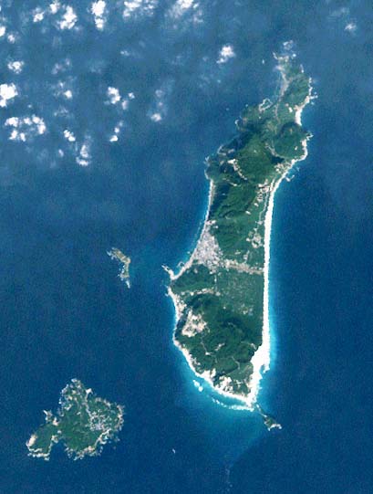
Landsat picture of
Shikinejima Island, Izu islands, Japan. '''Source:'''
295:– If you remix, transform, or build upon the material, you must distribute your contributions under the
1212:
898:
243:
1092:
548:
531:
513:
468:
91:
334:
345:
Permission is granted to copy, distribute and/or modify this document under the terms of the
310:
1277:
1197:
1122:
616:
607:
598:
589:
580:
571:
1162:
1207:
1172:
1127:
203:
924:
339:
121:
Landsat picture of
Niijima (right) and Shikinejima Island (left), Izu islands, Japan.
78:
179:
161:
1252:
1192:
1257:
1222:
1202:
942:
1182:
1147:
914:
886:
138:
1177:
1082:
160:
The
Landsat satellite pictures are used for this image. The data came from
156:
919:
1237:
1232:
1187:
1167:
1052:
165:
1152:
843:
Click on a date/time to view the file as it appeared at that time.
1012:
982:
967:
207:
1227:
309:
This licensing tag was added to this file as part of the GFDL
220:
66:
1067:
1037:
183:
1297:
992:
415:
1112:
1102:
1047:
1032:
952:
403:
1062:
1267:
1027:
651:
Add a one-line explanation of what this file represents
1157:
957:
1072:
1022:
972:
754:
Creative
Commons Attribution-ShareAlike 3.0 Unported
737:
390:
351:, Version 1.2 or any later version published by the
110:
90:
Commons is a freely licensed media file repository.
617:
608:
599:
590:
581:
572:
56:(409 × 541 pixels, file size: 39 KB, MIME type:
1198:Discussioni progetto:Geografia/Isole/Archivio1
316:http://creativecommons.org/licenses/by-sa/3.0/
71:
1163:Discussioni utente:Flavio Filoni/Archivio 001
225:
8:
1208:Discussioni utente:Borgil/Cassetto 2006-2011
322:Creative Commons Attribution-Share Alike 3.0
1173:Progetto:Geografia/Isole/Inviti e benvenuti
272:– to copy, distribute and transmit the work
1322:
845:
647:
625:
116:Landsat Niijima and Shikinejima Island.jpg
52:Landsat_Niijima_and_Shikinejima_Island.jpg
935:The following other wikis use this file:
409:See below for original file information.
487:
444:
1324:
912:
821:
805:
787:
771:
751:
734:
718:
698:
682:
665:
662:
643:
636:
483:
440:
430:
418:
1193:Discussioni utente:Ramatteo/Archivio1
910:The following 3 pages use this file:
192:Transferred from Japanese Knowledge;
180:メリーランド大学 / Global Land Cover Facility
7:
1203:Discussioni utente:Betta27/archivio3
367:http://www.gnu.org/copyleft/fdl.html
247:Attribution-Share Alike 3.0 Unported
1183:Template:Benvenuto - progetto:Isole
1148:Discussioni utente:Silvio.dellacqua
834:
236:
231:
1315:
656:
650:
519:(恐らくPD。ランドサットの衛星写真→カシミールにて読み込み→補正)
474:(恐らくPD。ランドサットの衛星写真→カシミールにて読み込み→補正)
173:
148:
123:
103:
49:
655:
162:Global Land Cover Facility (GLCF)
1213:Discussioni utente:Mαρκος/2012/1
1178:Discussioni utente:Cittadinovara
641:
394:
338:
283:Under the following conditions:
242:This file is licensed under the
235:
230:
224:
149:
124:
70:
31:
21:
638:
46:No higher resolution available.
14:
637:
373:GNU Free Documentation License
358:GNU Free Documentation License
348:GNU Free Documentation License
26:
1:
36:
663:Items portrayed in this file
1188:Discussioni utente:Doge2727
1168:Discussioni utente:Theridel
1099:Usage on frr.wikipedia.org
1044:Usage on en.wikivoyage.org
999:Usage on ckb.wikipedia.org
989:Usage on ceb.wikipedia.org
949:Usage on ast.wikipedia.org
435:ランドサットの衛星写真→カシミールにて読み込み→補正
1346:
1294:Usage on no.wikipedia.org
1284:Usage on mr.wikipedia.org
1274:Usage on ml.wikipedia.org
1264:Usage on lt.wikipedia.org
1249:Usage on ko.wikipedia.org
1219:Usage on ja.wikipedia.org
1144:Usage on it.wikipedia.org
1134:Usage on hy.wikipedia.org
1119:Usage on he.wikipedia.org
1109:Usage on fr.wikipedia.org
1089:Usage on fa.wikipedia.org
1083:Ōshima suprefetura (Tokio)
1079:Usage on eu.wikipedia.org
1059:Usage on es.wikipedia.org
1019:Usage on de.wikipedia.org
1009:Usage on cs.wikipedia.org
979:Usage on ca.wikipedia.org
964:Usage on az.wikipedia.org
939:Usage on ar.wikipedia.org
482:
439:
429:
417:
297:same or compatible license
154:ランドサットの衛星写真→カシミールにて読み込み→補正
1153:Discussioni utente:Sal73x
835:
567:
402:This file was moved from
393:
255:
223:
164:, and are processed with
16:
640:
542:17 November 2004, 10:20
525:13 November 2004, 11:07
353:Free Software Foundation
77:This is a file from the
892:
508:12 October 2004, 14:15
199:
144:
137:
134:
113:
81:. Information from its
895:ja:画像:新島式根島衛星写真001.jpg
462:12 October 2004, 14:15
194:ja:画像:新島式根島衛星写真001.jpg
84:description page there
1053:Pokémon Tour of Japan
899:Category:Izu Islands
249:license. Subject to
387:Original upload log
278:– to adapt the work
871:04:48, 5 July 2006
404:Japanese Knowledge
208:Japanese Knowledge
178:衛星画像が用いられています。これは、
1333:
1332:
1307:more global usage
931:Global file usage
903:
721:copyright license
649:
635:
634:
629:
563:
562:
559:
558:
479:
478:
384:
383:
333:
332:
213:
212:
191:
190:
99:
98:
79:Wikimedia Commons
32:Global file usage
1337:
1323:
1013:Izu (souostroví)
983:Niijima (Ōshima)
883:
685:copyright status
630:
491:Date/Time (UTC)
488:
448:Date/Time (UTC)
445:
424:新島式根島衛星写真001.jpg
416:
398:
397:
391:
380:
377:
374:
371:
368:
342:
335:
329:
326:
323:
320:
317:
314:
311:licensing update
299:as the original.
244:Creative Commons
239:
238:
234:
233:
228:
227:
221:
157:
153:
140:
128:
117:
111:
95:
74:
73:
67:
61:
59:
1345:
1344:
1340:
1339:
1338:
1336:
1335:
1334:
1311:
1068:Niijima (Tokio)
1038:Niijima (Tokio)
1003:دوورگەکانی ئیزو
929:
904:
889:
881:
837:
836:
833:
832:
831:
830:
829:
828:
827:
826:
824:
814:
813:
812:
810:
799:
798:
797:
796:
795:
794:
793:
792:
790:
789:12 October 2004
780:
779:
778:
776:
765:
764:
763:
762:
761:
760:
759:
758:
756:
745:
744:
743:
742:
741:
739:
727:
726:
725:
723:
712:
711:
710:
709:
708:
707:
706:
705:
703:
691:
690:
689:
687:
676:
675:
674:
673:
672:
670:
654:
653:
652:
619:
610:
601:
592:
583:
574:
570:
395:
389:
378:
375:
372:
369:
366:
327:
324:
321:
318:
315:
308:
219:
214:
187:
155:
139:12 October 2004
130:
115:
108:
101:
100:
89:
88:
87:is shown below.
63:
57:
55:
48:
47:
12:
11:
5:
1343:
1341:
1331:
1330:
1327:
1314:
1309:of this file.
1303:
1302:
1301:
1300:
1292:
1291:
1290:
1282:
1281:
1280:
1272:
1271:
1270:
1262:
1261:
1260:
1255:
1247:
1246:
1245:
1240:
1235:
1230:
1225:
1217:
1216:
1215:
1210:
1205:
1200:
1195:
1190:
1185:
1180:
1175:
1170:
1165:
1160:
1155:
1150:
1142:
1141:
1140:
1138:Իձու (կղզիներ)
1132:
1131:
1130:
1125:
1123:ניי-ג'ימה
1117:
1116:
1115:
1107:
1106:
1105:
1097:
1096:
1095:
1087:
1086:
1085:
1077:
1076:
1075:
1070:
1065:
1057:
1056:
1055:
1050:
1042:
1041:
1040:
1035:
1030:
1025:
1017:
1016:
1015:
1007:
1006:
1005:
997:
996:
995:
987:
986:
985:
977:
976:
975:
970:
962:
961:
960:
955:
947:
946:
945:
933:
932:
928:
927:
925:Niijima, Tokyo
922:
917:
908:
907:
902:
901:
891:
887:
884:
878:
873:
868:
864:
863:
860:
857:
854:
851:
848:
841:
840:
825:
822:
820:
819:
818:
817:
816:
815:
811:
806:
804:
803:
802:
801:
800:
791:
788:
786:
785:
784:
783:
782:
781:
777:
772:
770:
769:
768:
767:
766:
757:
752:
750:
749:
748:
747:
746:
740:
735:
733:
732:
731:
730:
729:
728:
724:
719:
717:
716:
715:
714:
713:
704:
699:
697:
696:
695:
694:
693:
692:
688:
683:
681:
680:
679:
678:
677:
671:
666:
664:
661:
660:
659:
658:
657:
646:
645:
642:
639:
633:
632:
565:
564:
561:
560:
557:
556:
551:
546:
543:
539:
538:
534:
529:
526:
522:
521:
516:
511:
509:
505:
504:
498:
495:
492:
485:
481:
480:
477:
476:
471:
466:
463:
459:
458:
455:
452:
449:
442:
438:
437:
432:
428:
427:
420:
412:
411:
399:
388:
385:
382:
381:
343:
331:
330:
305:
304:
303:
302:
301:
300:
290:
281:
280:
279:
273:
266:You are free:
261:
260:
257:
256:
254:
240:
218:
215:
211:
210:
201:
197:
196:
189:
188:
170:
169:
146:
142:
141:
136:
132:
131:
118:
109:
107:
104:
102:
97:
96:
75:
65:
64:
45:
41:
40:
39:
34:
29:
24:
19:
13:
10:
9:
6:
4:
3:
2:
1342:
1328:
1325:
1321:
1318:
1312:
1310:
1308:
1299:
1296:
1295:
1293:
1289:
1286:
1285:
1283:
1279:
1276:
1275:
1273:
1269:
1266:
1265:
1263:
1259:
1256:
1254:
1251:
1250:
1248:
1244:
1243:利用者:っ/画廊/衛星画像
1241:
1239:
1236:
1234:
1231:
1229:
1226:
1224:
1221:
1220:
1218:
1214:
1211:
1209:
1206:
1204:
1201:
1199:
1196:
1194:
1191:
1189:
1186:
1184:
1181:
1179:
1176:
1174:
1171:
1169:
1166:
1164:
1161:
1159:
1156:
1154:
1151:
1149:
1146:
1145:
1143:
1139:
1136:
1135:
1133:
1129:
1126:
1124:
1121:
1120:
1118:
1114:
1111:
1110:
1108:
1104:
1101:
1100:
1098:
1094:
1091:
1090:
1088:
1084:
1081:
1080:
1078:
1074:
1071:
1069:
1066:
1064:
1061:
1060:
1058:
1054:
1051:
1049:
1046:
1045:
1043:
1039:
1036:
1034:
1031:
1029:
1026:
1024:
1021:
1020:
1018:
1014:
1011:
1010:
1008:
1004:
1001:
1000:
998:
994:
991:
990:
988:
984:
981:
980:
978:
974:
971:
969:
966:
965:
963:
959:
956:
954:
951:
950:
948:
944:
941:
940:
938:
937:
936:
930:
926:
923:
921:
918:
916:
913:
911:
905:
900:
896:
890:
885:
879:
877:
874:
872:
869:
866:
865:
861:
858:
855:
852:
849:
847:
846:
844:
838:
809:
775:
755:
738:
722:
702:
686:
669:
631:
628:
624:
620:
615:
611:
606:
602:
597:
593:
588:
584:
579:
575:
568:
566:
555:
554:({{Landsat}})
552:
550:
547:
544:
541:
540:
537:
535:
533:
530:
527:
524:
523:
520:
517:
515:
512:
510:
507:
506:
502:
499:
496:
493:
490:
489:
486:
484:Page history
475:
472:
470:
467:
464:
461:
460:
456:
453:
450:
447:
446:
443:
441:File history
436:
433:
426:
425:
421:
414:
413:
410:
407:
405:
400:
392:
386:
364:
361:. Subject to
360:
359:
354:
350:
349:
344:
341:
337:
336:
312:
307:
306:
298:
294:
291:
288:
285:
284:
282:
277:
274:
271:
268:
267:
265:
264:
263:
262:
259:
258:
252:
248:
245:
241:
229:
222:
216:
209:
205:
202:
198:
195:
186:により画像化したものです。
185:
181:
177:
172:
171:
167:
163:
159:
158:
152:
147:
143:
133:
127:
122:
119:
112:
105:
93:
86:
85:
80:
76:
69:
68:
62:
53:
44:
38:
35:
33:
30:
28:
25:
23:
20:
18:
15:
1319:
1316:
1304:
1113:Shikine-jima
1033:Shikine-jima
993:Shikine-jima
934:
909:
897:{{Landsat}}
842:
839:File history
622:
613:
604:
595:
586:
577:
569:
553:
536:
518:
501:Edit summary
473:
434:
431:Description
422:
408:
401:
356:
346:
319:CC BY-SA 3.0
292:
286:
275:
269:
150:
125:
120:
92:You can help
82:
50:
22:File history
1103:Izu Eilunen
1063:Shikinejima
1048:Izu Islands
968:İzu adaları
953:Shikinejima
915:Izu Islands
701:copyrighted
451:Dimensions
363:disclaimers
293:share alike
287:attribution
251:disclaimers
114:Description
1326:_error
1268:Idzu salos
1093:جزایر ایزو
1028:Izu-Inseln
906:File usage
880:409 × 541
856:Dimensions
823:image/jpeg
808:media type
618:македонски
419:File name
182:所蔵のデータにより、
166:Kashmir 3D
58:image/jpeg
27:File usage
1158:Isole Izu
853:Thumbnail
850:Date/Time
774:inception
465:241 × 301
217:Licensing
129:新島式根島衛星写真
1313:Metadata
1298:Izuøyene
1288:इझू बेटे
1128:איי איזו
920:Nii-jima
644:Captions
503::
457:Comment
276:to remix
270:to share
37:Metadata
1073:Niijima
1023:Niijima
973:Niicima
958:Niijima
882:(39 KB)
867:current
862:Comment
668:depicts
648:English
582:English
573:Deutsch
184:カシミール3D
174:この画像には、
106:Summary
54:
1278:നീ-ജിമ
943:نيجيما
888:Taichi
621:
612:
603:
594:
585:
576:
200:Author
176:ランドサット
145:Source
1305:View
1253:이즈 제도
591:فارسی
497:User
494:Flag
454:User
1258:시키네섬
1223:伊豆諸島
859:User
379:true
376:true
370:GFDL
328:true
325:true
151:日本語:
135:Date
126:日本語:
17:File
1238:新島村
1233:式根島
627:+/−
609:한국어
600:日本語
206:at
1228:新島
253:.
168:.
1329:0
623:∙
614:∙
605:∙
596:∙
587:∙
578:∙
549:っ
545:m
532:っ
528:m
514:っ
469:っ
406:.
365:.
313:.
204:っ
94:.
60:)
Text is available under the Creative Commons Attribution-ShareAlike License. Additional terms may apply.
