343:
276:
226:
268:
218:
290:
240:
311:
349:
354:
67:
891:"}},"text\/plain":{"en":{"":"heading"}}},"{\"value\":{\"amount\":\"+202\",\"unit\":\"http:\\\/\\\/www.wikidata.org\\\/entity\\\/Q28390\"},\"type\":\"quantity\"}":{"text\/html":{"en":{"P7787":"202
670:"}},"text\/plain":{"en":{"":"heading"}}},"{\"value\":{\"amount\":\"+202\",\"unit\":\"http:\\\/\\\/www.wikidata.org\\\/entity\\\/Q28390\"},\"type\":\"quantity\"}":{"text\/html":{"en":{"P7787":"202
887:
259:
209:
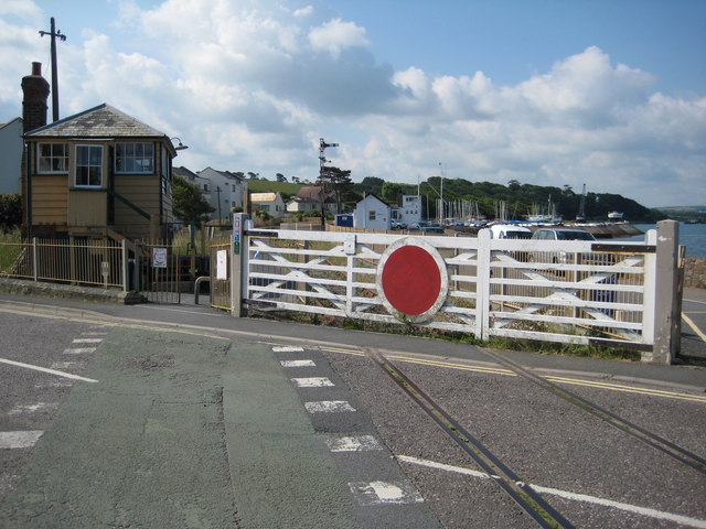
1010:== {{int:filedesc}} == {{Information |description={{en|1=Level crossing at Instow A level crossing and signal box beside the disused Bideford to Barnstaple railway line. This track is now a cycleway, however, a short piece of railway remains at this point
38:
401:– You must give appropriate credit, provide a link to the license, and indicate if changes were made. You may do so in any reasonable manner, but not in any way that suggests the licensor endorses you or your use.
78:
46:
888:
667:
121:
Level crossing and (left) signal box at Instow, Devon, seen from the north. A preserved part of the railway line that used to link
Bideford and Barnstaple.
787:
653:
617:
498:
283:
233:
837:
318:
1035:
This file contains additional information, probably added from the digital camera or scanner used to create or digitize it.
874:
481:
408:
992:
987:
552:
37:
929:
902:
858:
800:
771:
708:
681:
601:
573:
560:
545:
830:
815:
737:
637:
518:
465:
305:
364:
1038:
If the file has been modified from its original state, some details may not fully reflect the modified file.
1024:
1020:
The following pages on the
English Knowledge (XXG) use this file (pages on other projects are not listed):
407:– If you remix, transform, or build upon the material, you must distribute your contributions under the
325:
on the
Geograph website for the photographer's contact details. The copyright on this image is owned by
1003:
361:
895:"}},"text\/plain":{"en":{"P7787":"202 degree"}}}}": -->
674:"}},"text\/plain":{"en":{"P7787":"202 degree"}}}}": -->
86:
822:
807:
580:
162:
289:
239:
330:
73:
178:
130:
273:
223:
141:
151:
310:
322:
960:
Click on a date/time to view the file as it appeared at that time.
275:
225:
250:
200:
61:
260:
51° 02′ 59″ N, 4° 10′ 42″ W
210:
51° 03′ 01″ N, 4° 10′ 42″ W
111:
Level crossing at Instow - geograph.org.uk - 1355633.jpg
47:
Level_crossing_at_Instow_-_geograph.org.uk_-_1355633.jpg
449:
Add a one-line explanation of what this file represents
105:
85:
Commons is a freely licensed media file repository.
654:
Creative
Commons Attribution-ShareAlike 2.0 Generic
51:(640 × 480 pixels, file size: 83 KB, MIME type:
418:https://creativecommons.org/licenses/by-sa/2.0
66:
424:Creative Commons Attribution-Share Alike 2.0
342:
8:
892:
671:
384:– to copy, distribute and transmit the work
1040:
962:
445:
823:https://www.geograph.org.uk/photo/1355633
581:https://www.geograph.org.uk/profile/1837
1042:
1022:
916:
900:
872:
856:
785:
769:
751:
735:
695:
679:
651:
635:
615:
599:
532:
516:
496:
479:
463:
460:
441:
434:
253:
203:
282:View this and other nearby images on:
232:View this and other nearby images on:
7:
329:and is licensed for reuse under the
951:
365:Attribution-Share Alike 2.0 Generic
353:
348:
333:Attribution-ShareAlike 2.0 license.
1033:
454:
448:
339:
316:
115:
98:
44:
453:
682:coordinates of the point of view
439:
395:Under the following conditions:
360:This file is licensed under the
352:
347:
341:
309:
288:
274:
266:
238:
224:
216:
65:
21:
436:
116:
41:No higher resolution available.
14:
788:file available on the internet
435:
317:This image was taken from the
26:
1:
903:coordinates of depicted place
31:
838:Geograph Britain and Ireland
546:object of statement has role
461:Items portrayed in this file
265:
215:
191:Philip Halling /
172:Philip Halling /
1064:
918:51°2'59.24"N, 4°10'42.24"W
409:same or compatible license
952:
697:51°3'0.54"N, 4°10'41.88"W
16:
801:geograph.org.uk image ID
438:
375:
193:Level crossing at Instow
174:Level crossing at Instow
72:This is a file from the
1009:
988:08:07, 28 February 2011
163:required by the license
147:
136:
129:
126:
108:
76:. Information from its
1025:Instow railway station
323:this photograph's page
294:51.049790; -4.178400
244:51.050150; -4.178300
79:description page there
859:location of creation
390:– to adapt the work
561:author name string
1051:
1050:
1013:
894:
673:
638:copyright license
499:Instow Signal Box
447:
338:
337:
321:collection. See
299:
298:
249:
248:
198:
197:
166:
94:
93:
74:Wikimedia Commons
1055:
1041:
1000:
940:
939:
934:
840:
835:
825:
820:
816:described at URL
810:
805:
719:
718:
713:
602:copyright status
583:
578:
568:
565:
555:
550:
431:
428:
425:
422:
419:
411:as the original.
373:
362:Creative Commons
356:
355:
351:
350:
345:
344:
331:Creative Commons
319:Geograph project
313:
306:
295:
292:
278:
277:
271:
270:
269:
263:
262:
251:
245:
242:
228:
227:
221:
220:
219:
213:
212:
201:
160:
132:
120:
112:
106:
90:
69:
68:
62:
56:
54:
1063:
1062:
1058:
1057:
1056:
1054:
1053:
1052:
1029:
1021:
1014:
1006:
998:
954:
953:
950:
949:
948:
947:
946:
945:
944:
943:
942:
941:
937:
935:
932:
923:
922:
921:
919:
909:
908:
907:
905:
886:
885:
884:
883:
882:
881:
880:
879:
877:
865:
864:
863:
861:
850:
849:
848:
847:
846:
845:
844:
843:
842:
841:
836:
833:
827:
826:
821:
818:
812:
811:
806:
803:
794:
793:
792:
790:
778:
777:
776:
774:
763:
762:
761:
760:
759:
758:
757:
756:
754:
744:
743:
742:
740:
729:
728:
727:
726:
725:
724:
723:
722:
721:
720:
716:
714:
711:
702:
701:
700:
698:
688:
687:
686:
684:
665:
664:
663:
662:
661:
660:
659:
658:
656:
644:
643:
642:
640:
629:
628:
627:
626:
625:
624:
623:
622:
620:
608:
607:
606:
604:
593:
592:
591:
590:
589:
588:
587:
586:
585:
584:
579:
576:
570:
569:
566:
563:
557:
556:
551:
548:
539:
538:
537:
535:
525:
524:
523:
521:
510:
509:
508:
507:
506:
505:
504:
503:
501:
490:
489:
488:
487:
486:
484:
472:
471:
470:
468:
452:
451:
450:
433:
432:
429:
426:
423:
420:
417:
416:
374:
371:
368:
357:
334:
304:
293:
267:
258:
257:
254:Object location
243:
217:
208:
207:
204:Camera location
199:
188:
181:
169:
142:geograph.org.uk
122:
110:
103:
96:
95:
84:
83:
82:is shown below.
58:
52:
50:
43:
42:
12:
11:
5:
1061:
1059:
1049:
1048:
1045:
1032:
1028:
1027:
1019:
1018:
1017:
1012:
1011:
1008:
1004:
1001:
995:
990:
985:
981:
980:
977:
974:
971:
968:
965:
958:
957:
928:
927:
926:
925:
924:
920:
917:
915:
914:
913:
912:
911:
910:
906:
901:
899:
898:
897:
896:
890:
878:
873:
871:
870:
869:
868:
867:
866:
862:
857:
855:
854:
853:
852:
851:
829:
828:
814:
813:
799:
798:
797:
796:
795:
791:
786:
784:
783:
782:
781:
780:
779:
775:
772:source of file
770:
768:
767:
766:
765:
764:
755:
752:
750:
749:
748:
747:
746:
745:
741:
736:
734:
733:
732:
731:
730:
707:
706:
705:
704:
703:
699:
696:
694:
693:
692:
691:
690:
689:
685:
680:
678:
677:
676:
675:
669:
657:
652:
650:
649:
648:
647:
646:
645:
641:
636:
634:
633:
632:
631:
630:
621:
616:
614:
613:
612:
611:
610:
609:
605:
600:
598:
597:
596:
595:
594:
572:
571:
567:Philip Halling
559:
558:
544:
543:
542:
541:
540:
536:
533:
531:
530:
529:
528:
527:
526:
522:
517:
515:
514:
513:
512:
511:
502:
497:
495:
494:
493:
492:
491:
485:
482:level crossing
480:
478:
477:
476:
475:
474:
473:
469:
464:
462:
459:
458:
457:
456:
455:
444:
443:
440:
437:
415:
414:
413:
412:
402:
393:
392:
391:
385:
378:You are free:
372:Philip Halling
369:
359:
358:
340:
336:
335:
327:Philip Halling
314:
303:
300:
297:
296:
286:
280:
255:
247:
246:
236:
230:
205:
196:
195:
189:
186:
183:
182:
177:
170:
167:
155:
154:
152:Philip Halling
149:
145:
144:
138:
134:
133:
128:
124:
123:
113:
104:
102:
99:
97:
92:
91:
70:
60:
59:
40:
36:
35:
34:
29:
24:
19:
13:
10:
9:
6:
4:
3:
2:
1060:
1046:
1043:
1039:
1036:
1030:
1026:
1023:
1015:
1007:
1002:
996:
994:
991:
989:
986:
983:
982:
978:
975:
972:
969:
966:
964:
963:
961:
955:
931:
904:
876:
860:
839:
832:
824:
817:
809:
802:
789:
773:
739:
710:
683:
655:
639:
619:
603:
582:
575:
562:
554:
547:
520:
500:
483:
467:
421:CC BY-SA 2.0
410:
406:
403:
400:
397:
396:
394:
389:
386:
383:
380:
379:
377:
376:
370:Attribution:
366:
363:
346:
332:
328:
324:
320:
315:
312:
308:
307:
301:
291:
287:
285:
284:OpenStreetMap
281:
279:
261:
256:
252:
241:
237:
235:
234:OpenStreetMap
231:
229:
211:
206:
202:
194:
190:
185:
184:
180:
176: /
175:
171:
164:
159:
157:
156:
153:
150:
146:
143:
139:
135:
125:
119:
114:
107:
100:
88:
81:
80:
75:
71:
64:
63:
57:
48:
39:
33:
30:
28:
25:
23:
20:
18:
15:
1037:
1034:
959:
956:File history
753:11 June 2009
553:photographer
404:
398:
387:
381:
326:
264:
214:
192:
179:CC BY-SA 2.0
173:
131:11 June 2009
117:
87:You can help
77:
45:
22:File history
1005:GeographBot
618:copyrighted
405:share alike
399:attribution
158:Attribution
109:Description
1044:_error
1016:File usage
997:640 × 480
973:Dimensions
534:some value
53:image/jpeg
27:File usage
970:Thumbnail
967:Date/Time
738:inception
302:Licensing
187:InfoField
168:InfoField
118:English:
1031:Metadata
831:operator
442:Captions
388:to remix
382:to share
367:license.
32:Metadata
999:(83 KB)
984:current
979:Comment
930:heading
889:heading
808:1355633
709:heading
668:heading
519:creator
466:depicts
446:English
101:Summary
49:
938:degree
893:degree
875:Instow
717:degree
672:degree
272:
222:
148:Author
137:Source
140:From
976:User
936:202
715:202
430:true
427:true
127:Date
17:File
574:URL
933::
834::
819::
804::
712::
577::
564::
549::
1047:0
165:)
161:(
89:.
55:)
Text is available under the Creative Commons Attribution-ShareAlike License. Additional terms may apply.
_heading:202.00&language=en)
_heading:202.00&language=en)
