33:
386:
319:
269:
311:
261:
333:
283:
354:
392:
397:
89:
828:
692:"}},"text\/plain":{"en":{"":"heading"}}},"{\"value\":{\"amount\":\"+225\",\"unit\":\"http:\\\/\\\/www.wikidata.org\\\/entity\\\/Q28390\"},\"type\":\"quantity\"}":{"text\/html":{"en":{"P7787":"225
628:"}},"text\/plain":{"en":{"":"heading"}}},"{\"value\":{\"amount\":\"+225\",\"unit\":\"http:\\\/\\\/www.wikidata.org\\\/entity\\\/Q28390\"},\"type\":\"quantity\"}":{"text\/html":{"en":{"P7787":"225
624:
252:
55:
51:
47:
43:
37:
147:
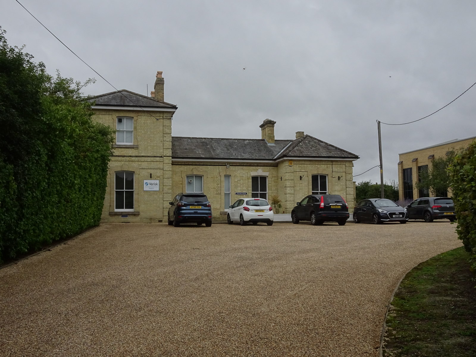
Opened in 1865 by the Great
Eastern Railway on the line from Marks Tey to Cambridge, this station closed in 1967. View south west at the former forecourt. It had become part of a small industrial estate when this image was
68:
444:– You must give appropriate credit, provide a link to the license, and indicate if changes were made. You may do so in any reasonable manner, but not in any way that suggests the licensor endorses you or your use.
100:
689:
625:
859:
827:
822:
59:
32:
189:
577:
541:
326:
276:
361:
451:
759:
730:
703:
666:
639:
525:
597:
561:
508:
348:
407:
855:
The following pages on the
English Knowledge (XXG) use this file (pages on other projects are not listed):
450:– If you remix, transform, or build upon the material, you must distribute your contributions under the
368:
on the
Geograph website for the photographer's contact details. The copyright on this image is owned by
404:
696:"}},"text\/plain":{"en":{"P7787":"225 degree"}}}}": -->
632:"}},"text\/plain":{"en":{"P7787":"225 degree"}}}}": -->
108:
838:
205:
332:
282:
373:
95:
221:
266:
157:
316:
178:
168:
353:
365:
133:
Linton railway station (site), Cambridgeshire (geograph 6608425).jpg
795:
Click on a date/time to view the file as it appeared at that time.
318:
268:
293:
243:
83:
303:
52° 05′ 43.8″ N, 0° 16′ 12″ E
253:
52° 05′ 44.8″ N, 0° 16′ 14″ E
492:
Add a one-line explanation of what this file represents
73:(1,600 × 1,200 pixels, file size: 454 KB, MIME type:
196:
Creative
Commons Attribution Share-alike license 2.0
127:
107:
Commons is a freely licensed media file repository.
578:
Creative
Commons Attribution-ShareAlike 2.0 Generic
461:https://creativecommons.org/licenses/by-sa/2.0
88:
467:Creative Commons Attribution-Share Alike 2.0
385:
236:Linton railway station (site), Cambridgeshire
217:Linton railway station (site), Cambridgeshire
144:Linton railway station (site), Cambridgeshire
8:
693:
629:
427:– to copy, distribute and transmit the work
797:
488:
860:Linton railway station (Cambridgeshire)
857:
773:
757:
717:
701:
653:
637:
611:
595:
575:
559:
539:
523:
506:
503:
484:
477:
296:
246:
845:Transferred from geograph.co.uk using
325:View this and other nearby images on:
275:View this and other nearby images on:
7:
372:and is licensed for reuse under the
786:
408:Attribution-Share Alike 2.0 Generic
396:
391:
376:Attribution-ShareAlike 2.0 license.
497:
491:
382:
359:
137:
120:
66:
496:
640:coordinates of the point of view
482:
438:Under the following conditions:
403:This file is licensed under the
395:
390:
384:
352:
331:
317:
309:
281:
267:
259:
87:
21:
479:
138:
14:
478:
360:This image was taken from the
26:
1:
704:coordinates of depicted place
655:52°5'44.754"N, 0°16'14.340"E
504:Items portrayed in this file
308:
258:
234:Nigel Thompson /
215:Nigel Thompson /
876:
719:52°5'43.84"N, 0°16'12.18"E
452:same or compatible license
787:
16:
823:20:33, 19 September 2020
481:
418:
94:This is a file from the
844:
206:required by the license
184:
174:
163:
156:
153:
130:
98:. Information from its
366:this photograph's page
337:52.095510; 0.270050
287:52.095765; 0.270650
101:description page there
36:Size of this preview:
60:1,600 × 1,200 pixels
433:– to adapt the work
42:Other resolutions:
56:1,280 × 960 pixels
52:1,024 × 768 pixels
848:
695:
631:
562:copyright license
490:
381:
380:
364:collection. See
342:
341:
292:
291:
241:
240:
209:
193:
190:Reusing this file
116:
115:
96:Wikimedia Commons
867:
835:
741:
740:
735:
677:
676:
671:
613:3 September 2020
526:copyright status
474:
471:
468:
465:
462:
454:as the original.
416:
405:Creative Commons
399:
398:
394:
393:
388:
387:
374:Creative Commons
362:Geograph project
356:
349:
338:
335:
321:
320:
314:
313:
312:
306:
305:
294:
288:
285:
271:
270:
264:
263:
262:
256:
255:
244:
203:
187:
159:
158:3 September 2020
142:
134:
128:
112:
91:
90:
84:
78:
76:
63:
48:640 × 480 pixels
44:320 × 240 pixels
38:800 × 600 pixels
875:
874:
870:
869:
868:
866:
865:
864:
856:
849:
841:
833:
789:
788:
785:
784:
783:
782:
781:
780:
779:
778:
776:
766:
765:
764:
762:
751:
750:
749:
748:
747:
746:
745:
744:
743:
742:
738:
736:
733:
724:
723:
722:
720:
710:
709:
708:
706:
687:
686:
685:
684:
683:
682:
681:
680:
679:
678:
674:
672:
669:
660:
659:
658:
656:
646:
645:
644:
642:
623:
622:
621:
620:
619:
618:
617:
616:
614:
604:
603:
602:
600:
589:
588:
587:
586:
585:
584:
583:
582:
580:
568:
567:
566:
564:
553:
552:
551:
550:
549:
548:
547:
546:
544:
532:
531:
530:
528:
517:
516:
515:
514:
513:
511:
495:
494:
493:
476:
475:
472:
469:
466:
463:
460:
459:
417:
414:
411:
400:
377:
347:
336:
310:
301:
300:
297:Object location
286:
260:
251:
250:
247:Camera location
242:
231:
224:
212:
169:geograph.org.uk
149:
132:
125:
118:
117:
106:
105:
104:is shown below.
80:
74:
72:
65:
64:
41:
12:
11:
5:
873:
871:
863:
862:
854:
853:
852:
847:
846:
843:
839:
836:
832:1,600 × 1,200
830:
825:
820:
816:
815:
812:
809:
806:
803:
800:
793:
792:
777:
774:
772:
771:
770:
769:
768:
767:
763:
758:
756:
755:
754:
753:
752:
729:
728:
727:
726:
725:
721:
718:
716:
715:
714:
713:
712:
711:
707:
702:
700:
699:
698:
697:
691:
665:
664:
663:
662:
661:
657:
654:
652:
651:
650:
649:
648:
647:
643:
638:
636:
635:
634:
633:
627:
615:
612:
610:
609:
608:
607:
606:
605:
601:
596:
594:
593:
592:
591:
590:
581:
576:
574:
573:
572:
571:
570:
569:
565:
560:
558:
557:
556:
555:
554:
545:
540:
538:
537:
536:
535:
534:
533:
529:
524:
522:
521:
520:
519:
518:
512:
507:
505:
502:
501:
500:
499:
498:
487:
486:
483:
480:
458:
457:
456:
455:
445:
436:
435:
434:
428:
421:You are free:
415:Nigel Thompson
412:
402:
401:
383:
379:
378:
370:Nigel Thompson
357:
346:
343:
340:
339:
329:
323:
298:
290:
289:
279:
273:
248:
239:
238:
232:
229:
226:
225:
220:
213:
210:
198:
197:
194:
182:
181:
179:Nigel Thompson
176:
172:
171:
165:
161:
160:
155:
151:
150:
135:
126:
124:
121:
119:
114:
113:
92:
82:
81:
35:
31:
30:
29:
24:
19:
13:
10:
9:
6:
4:
3:
2:
872:
861:
858:
850:
842:
837:
831:
829:
826:
824:
821:
818:
817:
813:
810:
807:
804:
801:
799:
798:
796:
790:
761:
732:
705:
668:
641:
599:
579:
563:
543:
527:
510:
464:CC BY-SA 2.0
453:
449:
446:
443:
440:
439:
437:
432:
429:
426:
423:
422:
420:
419:
413:Attribution:
409:
406:
389:
375:
371:
367:
363:
358:
355:
351:
350:
344:
334:
330:
328:
327:OpenStreetMap
324:
322:
304:
299:
295:
284:
280:
278:
277:OpenStreetMap
274:
272:
254:
249:
245:
237:
233:
228:
227:
223:
219: /
218:
214:
207:
202:
200:
199:
195:
191:
186:
183:
180:
177:
173:
170:
166:
162:
152:
146:
145:
141:
136:
129:
122:
110:
103:
102:
97:
93:
86:
85:
79:
70:
69:Original file
61:
57:
53:
49:
45:
39:
34:
28:
25:
23:
20:
18:
15:
794:
791:File history
447:
441:
430:
424:
369:
307:
257:
235:
222:CC BY-SA 2.0
216:
143:
139:
109:You can help
99:
67:
22:File history
840:Lamberhurst
542:copyrighted
448:share alike
442:attribution
201:Attribution
131:Description
851:File usage
808:Dimensions
775:image/jpeg
760:media type
185:Permission
75:image/jpeg
27:File usage
805:Thumbnail
802:Date/Time
598:inception
345:Licensing
230:InfoField
211:InfoField
140:English:
834:(454 KB)
485:Captions
431:to remix
425:to share
410:license.
819:current
814:Comment
731:heading
690:heading
667:heading
626:heading
509:depicts
489:English
123:Summary
71:
739:degree
694:degree
675:degree
630:degree
315:
265:
175:Author
164:Source
148:taken.
167:From
811:User
737:225
673:225
473:true
470:true
154:Date
17:File
734::
670::
58:|
54:|
50:|
46:|
40:.
208:)
204:(
192:)
188:(
111:.
77:)
62:.
Text is available under the Creative Commons Attribution-ShareAlike License. Additional terms may apply.
,_Cambridgeshire_(geograph_6608425).jpg)
,_Cambridgeshire_(geograph_6608425).jpg¶ms=052.095765_N_0000.270650_E_globe:Earth_type:camera_source:geograph-osgb36(TL55644659)_heading:225.00&language=en)
,_Cambridgeshire_(geograph_6608425).jpg¶ms=052.095510_N_0000.270050_E_globe:Earth_class:object_type:object_source:geograph-osgb36(TL55604656)_heading:225.00&language=en)
