582:
610:
452:
596:
568:
38:
407:
458:
632:
463:
86:
913:
517:– You must give appropriate credit, provide a link to the license, and indicate if changes were made. You may do so in any reasonable manner, but not in any way that suggests the licensor endorses you or your use.
647:
349:
285:
424:
52:
48:
42:
97:
935:
422:; with no Invariant Sections, no Front-Cover Texts, and no Back-Cover Texts. A copy of the license is included in the section entitled
388:
65:
414:
824:
807:
790:
773:
756:
720:
524:
216:
140:
327:
263:
704:
419:
844:
740:
687:
643:
338:
274:
1219:
486:
482:
478:
474:
639:
961:
259: ; projection UTM ; système géodésique WGS84 ; relief ombré (image d'éclairage du N-O) ;
1169:
1154:
952:
The following pages on the
English Knowledge (XXG) use this file (pages on other projects are not listed):
581:
523:– If you remix, transform, or build upon the material, you must distribute your contributions under the
1139:
360:
323: ; UTM projection ; WGS84 datum ; shaded relief (image of N-W lightning position) ;
296:
470:
377:
1179:
186:
595:
567:
105:
912:
907:
56:
37:
609:
401:
1214:
412:
Permission is granted to copy, distribute and/or modify this document under the terms of the
923:
930:{{Information |Description= {{fr|Carte topographique et administrative en français du
631:
398:
I, the copyright holder of this work, hereby publish it under the following licenses:
353:
289:
92:
373:
1149:
342:
278:
1134:
1079:
316:
252:
1054:
1144:
228:
320:
1049:
164:
256:
1159:
1129:
956:
939:
931:
205:
175:
152:
136:
1164:
880:
Click on a date/time to view the file as it appeared at that time.
1074:
1019:
312:
248:
1189:
1124:
1089:
1024:
80:
215: : Une version svg existe pour les traductions :
1094:
1170:
Wikipédia:Atelier graphique/Cartes/Archives/juillet 2022
1155:
Wikipédia:Atelier graphique/Cartes/Archives/octobre 2010
1069:
1199:
1119:
671:
Add a one-line explanation of what this file represents
1204:
1059:
1044:
1034:
334:
270:
1140:
Wikipédia:Atelier graphique/Cartes/Archives/juin 2009
1114:
135:
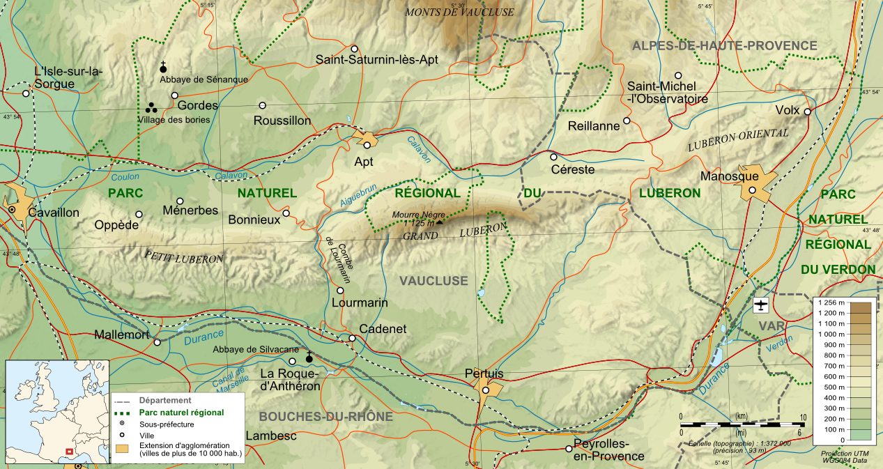
Carte topographique et administrative en français du
1104:
1039:
1009:
999:
989:
979:
938:)}}{{de|Topographische Karte / Verwaltungskarte zum
808:
757:
Creative
Commons Attribution-ShareAlike 3.0 Unported
418:, Version 1.2 or any later version published by the
119:
104:
Commons is a freely licensed media file repository.
70:(1,267 × 673 pixels, file size: 1.12 MB, MIME type:
1109:
1064:
825:
Creative
Commons Attribution-ShareAlike 2.0 Generic
791:
Creative
Commons Attribution-ShareAlike 1.0 Generic
774:
Creative
Commons Attribution-ShareAlike 2.5 Generic
650:to clean up, improve, create or translate as well.
1099:
350:Blank_map_of_Europe_-_Atelier_graphique_colors.svg
286:Blank_map_of_Europe_-_Atelier_graphique_colors.svg
1084:
174:Mapa topográfico y administrativo en francès del
1029:
163:Topographic and administrative map in French of
534:https://creativecommons.org/licenses/by-sa/3.0
85:
540:Creative Commons Attribution-Share Alike 3.0
451:
8:
295:Autres symboles (dont échelle) provenant de
151:Topographische Karte / Verwaltungskarte zum
500:– to copy, distribute and transmit the work
882:
667:
626:
552:You may select the license of your choice.
251:(SRTM3 v.2) (domaine public) éditées avec
972:The following other wikis use this file:
638:This map was improved or created by the
315:(SRTM3 v.2) (public domain) edited with
204:Carta topográfica e da administração do
954:
858:
842:
822:
805:
788:
771:
754:
738:
718:
702:
685:
682:
663:
656:
563:
269:Villes, chemins de fers, routes :
185:Carta topografica e amministrativa del
313:NASA Shuttle Radar Topography Mission
249:NASA Shuttle Radar Topography Mission
7:
1080:Villeneuve (Alpes-de-Haute-Provence)
430:http://www.gnu.org/copyleft/fdl.html
1055:Pierrerue (Alpes-de-Haute-Provence)
936:File:Luberon topographic map-fr.svg
871:
462:
457:
217:File:Luberon topographic map-fr.svg
141:File:Luberon topographic map-fr.svg
1145:Utilisateur:Bserin/brouillon1/PACA
676:
670:
637:
551:
448:
397:
302:
238:
199:
198:
190:
179:
168:
157:
145:
129:
117:
63:
675:
284:Locator map élaborée à partir de
1050:Saint-Michel-l'Observatoire
661:
630:
608:
594:
580:
566:
511:Under the following conditions:
469:This file is licensed under the
461:
456:
450:
406:
405:
191:
84:
31:
21:
1135:Abbaye Saint-Hilaire (Ménerbes)
658:
337:add-on for World Wind (see the
333:Cities, railways, roads :
303:
275:l'e-mail d'approbation de Demis
180:
169:
158:
14:
657:
436:GNU Free Documentation License
425:GNU Free Documentation License
415:GNU Free Documentation License
239:
146:
130:
125:Luberon topographic map-fr.png
26:
1:
1130:Triangle d'or du Luberon
356:under GFDL & CC-BY-SA-2.5
292:under GFDL & CC-BY-SA-2.5
247:Données topographiques de la
683:Items portrayed in this file
326:Borders, rivers : NASA
244:Création personnelle ;
1150:Forêt des cèdres du Luberon
273:add-on for World Wind (cf.
1238:
1211:Usage on ru.wikipedia.org
1196:Usage on oc.wikipedia.org
1186:Usage on nl.wikipedia.org
1176:Usage on he.wikipedia.org
1016:Usage on fr.wikipedia.org
1006:Usage on es.wikipedia.org
996:Usage on eo.wikipedia.org
986:Usage on da.wikipedia.org
976:Usage on cs.wikipedia.org
525:same or compatible license
311:Topographic data from the
872:
361:File:Maps template-fr.svg
297:File:Maps template-fr.svg
196:フランス語で表示したLuberonの地形·行政地図
16:
660:
491:
473:Attribution-Share Alike
420:Free Software Foundation
91:This is a file from the
962:User:Tpbradbury/Pertuis
929:
629:
559:
383:
369:
234:
227:
224:
122:
95:. Information from its
1165:Grand Vallat (Calavon)
348:Locator map made from
330:(SRTM Water Body Data)
266:(SRTM Water Body Data)
255:, et vectorisées avec
98:description page there
41:Size of this preview:
1160:Une année en Provence
1075:Saint-Martin-les-Eaux
1020:Roussillon (Vaucluse)
187:massiccio del Luberon
139:(svg original :
359:Others symbols from
908:12:47, 10 June 2009
646:(fr). You can
506:– to adapt the work
47:Other resolutions:
1190:Luberon (gebergte)
1125:Village des bories
1090:Pertuis (Vaucluse)
319:, vectorized with
57:1,267 × 673 pixels
1025:Massif du Luberon
968:Global file usage
945:
741:copyright license
669:
655:
654:
624:
623:
588:svg fr (original)
447:
446:
392:
389:Reusing this file
262:Lacs : NASA
155:, in Französische
113:
112:
93:Wikimedia Commons
32:Global file usage
1229:
934:(svg original :
920:
705:copyright status
634:
627:
612:
598:
584:
570:
547:
544:
541:
538:
535:
527:as the original.
471:Creative Commons
465:
464:
460:
459:
454:
453:
443:
440:
437:
434:
431:
409:
408:
402:
386:
308:Own work ;
307:
243:
241:Français :
230:
203:
195:
184:
173:
162:
150:
134:
132:Français :
126:
120:
109:
88:
87:
81:
75:
73:
60:
53:640 × 340 pixels
49:320 × 170 pixels
43:800 × 425 pixels
1237:
1236:
1232:
1231:
1230:
1228:
1227:
1226:
966:
953:
946:
926:
918:
874:
873:
870:
869:
868:
867:
866:
865:
864:
863:
861:
851:
850:
849:
847:
836:
835:
834:
833:
832:
831:
830:
829:
827:
816:
815:
814:
813:
812:
810:
799:
798:
797:
796:
795:
793:
782:
781:
780:
779:
778:
776:
765:
764:
763:
762:
761:
759:
747:
746:
745:
743:
732:
731:
730:
729:
728:
727:
726:
725:
723:
711:
710:
709:
707:
696:
695:
694:
693:
692:
690:
674:
673:
672:
651:
625:
618:
613:
604:
599:
590:
585:
576:
571:
555:
554:
553:
549:
548:
545:
542:
539:
536:
533:
532:
490:
466:
441:
438:
435:
432:
429:
400:
399:
365:
339:approval e-mail
301:
209:
197:
189:
178:
167:
156:
144:
124:
115:
114:
103:
102:
101:is shown below.
77:
71:
69:
62:
61:
46:
12:
11:
5:
1235:
1233:
1225:
1224:
1223:
1222:
1217:
1209:
1208:
1207:
1202:
1194:
1193:
1192:
1184:
1183:
1182:
1174:
1173:
1172:
1167:
1162:
1157:
1152:
1147:
1142:
1137:
1132:
1127:
1122:
1117:
1112:
1107:
1102:
1097:
1092:
1087:
1082:
1077:
1072:
1067:
1062:
1057:
1052:
1047:
1042:
1037:
1032:
1027:
1022:
1014:
1013:
1012:
1004:
1003:
1002:
994:
993:
992:
984:
983:
982:
970:
969:
965:
964:
959:
951:
950:
949:
944:
943:
928:
924:
921:
915:
910:
905:
901:
900:
897:
894:
891:
888:
885:
878:
877:
862:
859:
857:
856:
855:
854:
853:
852:
848:
843:
841:
840:
839:
838:
837:
828:
823:
821:
820:
819:
818:
817:
811:
806:
804:
803:
802:
801:
800:
794:
789:
787:
786:
785:
784:
783:
777:
772:
770:
769:
768:
767:
766:
760:
755:
753:
752:
751:
750:
749:
748:
744:
739:
737:
736:
735:
734:
733:
724:
719:
717:
716:
715:
714:
713:
712:
708:
703:
701:
700:
699:
698:
697:
691:
686:
684:
681:
680:
679:
678:
677:
666:
665:
662:
659:
653:
652:
648:propose images
635:
622:
621:
620:
619:
614:
607:
605:
600:
593:
591:
586:
579:
577:
572:
565:
561:
560:Other versions
557:
556:
550:
531:
530:
529:
528:
518:
509:
508:
507:
501:
494:You are free:
468:
467:
449:
445:
444:
410:
396:
395:
393:
381:
380:
371:
367:
366:
364:
363:
357:
346:
331:
324:
300:
299:
293:
282:
267:
260:
236:
232:
231:
226:
222:
221:
220:
219:
127:
118:
116:
111:
110:
89:
79:
78:
40:
36:
35:
34:
29:
24:
19:
13:
10:
9:
6:
4:
3:
2:
1234:
1221:
1218:
1216:
1213:
1212:
1210:
1206:
1203:
1201:
1198:
1197:
1195:
1191:
1188:
1187:
1185:
1181:
1178:
1177:
1175:
1171:
1168:
1166:
1163:
1161:
1158:
1156:
1153:
1151:
1148:
1146:
1143:
1141:
1138:
1136:
1133:
1131:
1128:
1126:
1123:
1121:
1118:
1116:
1113:
1111:
1108:
1106:
1103:
1101:
1098:
1096:
1093:
1091:
1088:
1086:
1083:
1081:
1078:
1076:
1073:
1071:
1068:
1066:
1063:
1061:
1058:
1056:
1053:
1051:
1048:
1046:
1043:
1041:
1038:
1036:
1033:
1031:
1028:
1026:
1023:
1021:
1018:
1017:
1015:
1011:
1008:
1007:
1005:
1001:
998:
997:
995:
991:
988:
987:
985:
981:
978:
977:
975:
974:
973:
967:
963:
960:
958:
955:
947:
941:
937:
933:
927:
922:
916:
914:
911:
909:
906:
903:
902:
898:
895:
892:
889:
886:
884:
883:
881:
875:
846:
826:
809:
792:
775:
758:
742:
722:
706:
689:
649:
645:
641:
640:Wikigraphists
636:
633:
628:
617:
611:
606:
603:
597:
592:
589:
583:
578:
575:
569:
564:
562:
558:
537:CC BY-SA 3.0
526:
522:
519:
516:
513:
512:
510:
505:
502:
499:
496:
495:
493:
492:
488:
484:
480:
476:
472:
455:
427:
426:
421:
417:
416:
411:
404:
403:
394:
390:
385:
382:
379:
378:fr:Bourrichon
375:
372:
368:
362:
358:
355:
351:
347:
344:
340:
336:
332:
329:
325:
322:
318:
314:
310:
309:
306:
298:
294:
291:
287:
283:
280:
276:
272:
268:
265:
261:
258:
254:
250:
246:
245:
242:
237:
233:
223:
218:
214:
211:
210:
207:
202:
194:
188:
183:
177:
172:
166:
161:
154:
149:
142:
138:
133:
128:
121:
107:
100:
99:
94:
90:
83:
82:
76:
67:
66:Original file
58:
54:
50:
44:
39:
33:
30:
28:
25:
23:
20:
18:
15:
1220:Деревня бори
971:
942:, in Französ
917:1,267 × 673
879:
876:File history
615:
601:
587:
573:
520:
514:
503:
497:
475:3.0 Unported
423:
413:
304:
240:
212:
200:
192:
181:
170:
159:
147:
131:
106:You can help
96:
64:
22:File history
1070:Saint-Maime
860:9 June 2009
721:copyrighted
644:Graphic Lab
521:share alike
515:attribution
487:1.0 Generic
483:2.0 Generic
479:2.5 Generic
354:Historicair
352:created by
343:Demis forum
290:Historicair
288:created by
279:Demis forum
229:9 June 2009
201:Português:
123:Description
1200:Sant Maime
1180:הרי לוברון
1120:Villelaure
948:File usage
925:Bourrichon
893:Dimensions
384:Permission
374:Bourrichon
208:em francês
182:Italiano:
27:File usage
1060:Niozelles
1045:Montfuron
1035:Lourmarin
919:(1.12 MB)
890:Thumbnail
887:Date/Time
845:inception
602:raster en
574:raster fr
305:English:
171:Español:
160:English:
148:Deutsch:
72:image/png
1215:Лурмарен
1115:Vaugines
1095:Véroncle
664:Captions
504:to remix
498:to share
489:license.
345:) ;
341:and the
321:Inkscape
281:) ;
257:Inkscape
1105:Puyvert
1040:Sigonce
1010:Luberon
1000:Luberon
990:Luberon
980:Luberon
957:Luberon
940:Luberon
932:Luberon
904:current
899:Comment
688:depicts
668:English
642:of the
206:Luberon
176:Luberon
165:Luberon
153:Luberon
137:Luberon
68:
1110:Sannes
1065:Limans
616:svg en
370:Author
277:et le
235:Source
1100:Puget
335:Demis
271:Demis
1205:Vòus
1085:Volx
896:User
546:true
543:true
485:and
442:true
439:true
433:GFDL
328:SWBD
317:3DEM
264:SWBD
253:3DEM
225:Date
213:Note
193:日本語:
17:File
1030:Apt
481:,
477:,
376:-
55:|
51:|
45:.
428:.
391:)
387:(
143:)
108:.
74:)
59:.
Text is available under the Creative Commons Attribution-ShareAlike License. Additional terms may apply.