349:
282:
232:
274:
224:
296:
246:
317:
355:
360:
72:
825:"}},"text\/plain":{"en":{"":"heading"}}},"{\"value\":{\"amount\":\"+315\",\"unit\":\"http:\\\/\\\/www.wikidata.org\\\/entity\\\/Q28390\"},\"type\":\"quantity\"}":{"text\/html":{"en":{"P7787":"315
674:"}},"text\/plain":{"en":{"":"heading"}}},"{\"value\":{\"amount\":\"+315\",\"unit\":\"http:\\\/\\\/www.wikidata.org\\\/entity\\\/Q28390\"},\"type\":\"quantity\"}":{"text\/html":{"en":{"P7787":"315
927:
821:
215:
43:
944:== {{int:filedesc}} == {{Information |description={{en|1=Motcombe: looking along The Street The view northwest from outside the post office, along the main street, called simply The Street, towards the little Methodist chapel. To the right of the chapel i
126:
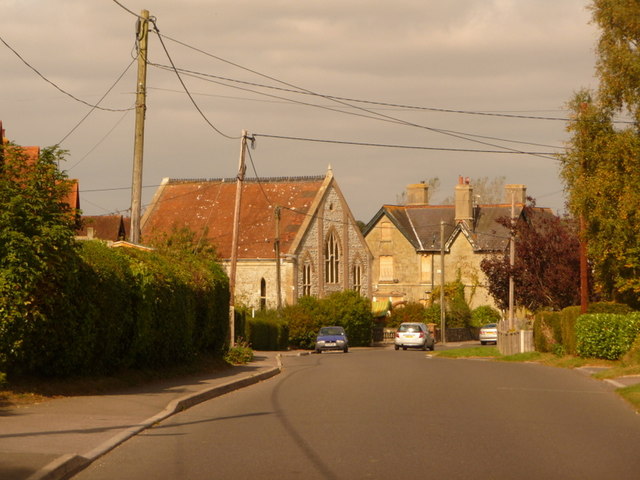
Motcombe: looking along The Street The view northwest from outside the post office, along the main street, called simply The Street, towards the little
Methodist chapel. To the right of the chapel is the boarded up Royal Oak
407:– You must give appropriate credit, provide a link to the license, and indicate if changes were made. You may do so in any reasonable manner, but not in any way that suggests the licensor endorses you or your use.
83:
51:
822:
671:
926:
921:
42:
757:
623:
587:
289:
239:
777:
324:
1079:
This file contains additional information, probably added from the digital camera or scanner used to create or digitize it.
414:
522:
863:
836:
785:
741:
712:
685:
571:
543:
530:
515:
800:
770:
643:
607:
488:
471:
311:
370:
1082:
If the file has been modified from its original state, some details may not fully reflect the modified file.
413:– If you remix, transform, or build upon the material, you must distribute your contributions under the
331:
on the
Geograph website for the photographer's contact details. The copyright on this image is owned by
937:
367:
829:"}},"text\/plain":{"en":{"P7787":"315 degree"}}}}": -->
678:"}},"text\/plain":{"en":{"P7787":"315 degree"}}}}": -->
91:
807:
792:
550:
168:
295:
245:
336:
78:
184:
1006:
136:
279:
229:
157:
147:
958:
316:
328:
894:
Click on a date/time to view the file as it appeared at that time.
116:
Motcombe, looking along The Street - geograph.org.uk - 1508602.jpg
52:
Motcombe,_looking_along_The_Street_-_geograph.org.uk_-_1508602.jpg
281:
231:
256:
206:
66:
1066:
266:
51° 01′ 52″ N, 2° 13′ 08″ W
216:
51° 01′ 50″ N, 2° 13′ 04″ W
455:
Add a one-line explanation of what this file represents
1026:
976:
1056:
1046:
1036:
1016:
996:
986:
110:
90:
Commons is a freely licensed media file repository.
624:
Creative
Commons Attribution-ShareAlike 2.0 Generic
56:(640 × 480 pixels, file size: 69 KB, MIME type:
424:https://creativecommons.org/licenses/by-sa/2.0
71:
430:Creative Commons Attribution-Share Alike 2.0
348:
8:
826:
675:
390:– to copy, distribute and transmit the work
1084:
896:
451:
969:The following other wikis use this file:
808:https://www.geograph.org.uk/photo/1508602
551:https://www.geograph.org.uk/profile/14700
1086:
956:
850:
834:
755:
739:
699:
683:
657:
641:
621:
605:
585:
569:
502:
486:
469:
466:
447:
440:
259:
209:
288:View this and other nearby images on:
238:View this and other nearby images on:
7:
335:and is licensed for reuse under the
954:The following page uses this file:
885:
371:Attribution-Share Alike 2.0 Generic
359:
354:
339:Attribution-ShareAlike 2.0 license.
1077:
1063:Usage on zh-min-nan.wikipedia.org
460:
454:
345:
322:
199:Motcombe: looking along The Street
180:Motcombe: looking along The Street
120:
103:
49:
459:
686:coordinates of the point of view
445:
401:Under the following conditions:
366:This file is licensed under the
358:
353:
347:
315:
294:
280:
272:
244:
230:
222:
70:
31:
21:
442:
121:
46:No higher resolution available.
14:
758:file available on the internet
441:
323:This image was taken from the
26:
1:
837:coordinates of depicted place
36:
778:Geograph Britain and Ireland
516:object of statement has role
467:Items portrayed in this file
271:
221:
1023:Usage on lld.wikipedia.org
973:Usage on ceb.wikipedia.org
1108:
1053:Usage on www.wikidata.org
1043:Usage on tr.wikipedia.org
1033:Usage on pl.wikipedia.org
1013:Usage on fr.wikipedia.org
1003:Usage on fa.wikipedia.org
993:Usage on es.wikipedia.org
983:Usage on cy.wikipedia.org
415:same or compatible license
886:
852:51°1'52.39"N, 2°13'7.68"W
701:51°1'50.48"N, 2°13'4.44"W
197:Chris Downer /
178:Chris Downer /
16:
786:geograph.org.uk image ID
444:
381:
77:This is a file from the
943:
169:required by the license
153:
142:
135:
132:
113:
81:. Information from its
329:this photograph's page
300:51.031220; -2.218800
250:51.030690; -2.217900
84:description page there
922:21:11, 2 March 2011
396:– to adapt the work
531:author name string
1095:
1094:
965:Global file usage
947:
828:
677:
659:26 September 2009
608:copyright license
453:
344:
343:
327:collection. See
305:
304:
255:
254:
204:
203:
172:
137:26 September 2009
99:
98:
79:Wikimedia Commons
32:Global file usage
1099:
1085:
934:
874:
873:
868:
810:
805:
801:described at URL
795:
790:
780:
775:
723:
722:
717:
572:copyright status
553:
548:
538:
535:
525:
520:
437:
434:
431:
428:
425:
417:as the original.
379:
368:Creative Commons
362:
361:
357:
356:
351:
350:
337:Creative Commons
325:Geograph project
319:
312:
301:
298:
284:
283:
277:
276:
275:
269:
268:
257:
251:
248:
234:
233:
227:
226:
225:
219:
218:
207:
166:
138:
125:
117:
111:
95:
74:
73:
67:
61:
59:
1107:
1106:
1102:
1101:
1100:
1098:
1097:
1096:
1073:
963:
948:
940:
932:
888:
887:
884:
883:
882:
881:
880:
879:
878:
877:
876:
875:
871:
869:
866:
857:
856:
855:
853:
843:
842:
841:
839:
820:
819:
818:
817:
816:
815:
814:
813:
812:
811:
806:
803:
797:
796:
791:
788:
782:
781:
776:
773:
764:
763:
762:
760:
748:
747:
746:
744:
733:
732:
731:
730:
729:
728:
727:
726:
725:
724:
720:
718:
715:
706:
705:
704:
702:
692:
691:
690:
688:
669:
668:
667:
666:
665:
664:
663:
662:
660:
650:
649:
648:
646:
635:
634:
633:
632:
631:
630:
629:
628:
626:
614:
613:
612:
610:
599:
598:
597:
596:
595:
594:
593:
592:
590:
578:
577:
576:
574:
563:
562:
561:
560:
559:
558:
557:
556:
555:
554:
549:
546:
540:
539:
536:
533:
527:
526:
521:
518:
509:
508:
507:
505:
495:
494:
493:
491:
480:
479:
478:
477:
476:
474:
458:
457:
456:
439:
438:
435:
432:
429:
426:
423:
422:
380:
377:
374:
363:
340:
310:
299:
273:
264:
263:
260:Object location
249:
223:
214:
213:
210:Camera location
205:
194:
187:
175:
148:geograph.org.uk
128:
115:
108:
101:
100:
89:
88:
87:is shown below.
63:
57:
55:
48:
47:
12:
11:
5:
1105:
1103:
1093:
1092:
1089:
1076:
1072:
1071:
1070:
1069:
1061:
1060:
1059:
1051:
1050:
1049:
1041:
1040:
1039:
1031:
1030:
1029:
1021:
1020:
1019:
1011:
1010:
1009:
1001:
1000:
999:
991:
990:
989:
981:
980:
979:
967:
966:
962:
961:
952:
951:
946:
945:
942:
938:
935:
929:
924:
919:
915:
914:
911:
908:
905:
902:
899:
892:
891:
862:
861:
860:
859:
858:
854:
851:
849:
848:
847:
846:
845:
844:
840:
835:
833:
832:
831:
830:
824:
799:
798:
784:
783:
769:
768:
767:
766:
765:
761:
756:
754:
753:
752:
751:
750:
749:
745:
742:source of file
740:
738:
737:
736:
735:
734:
711:
710:
709:
708:
707:
703:
700:
698:
697:
696:
695:
694:
693:
689:
684:
682:
681:
680:
679:
673:
661:
658:
656:
655:
654:
653:
652:
651:
647:
642:
640:
639:
638:
637:
636:
627:
622:
620:
619:
618:
617:
616:
615:
611:
606:
604:
603:
602:
601:
600:
591:
586:
584:
583:
582:
581:
580:
579:
575:
570:
568:
567:
566:
565:
564:
542:
541:
529:
528:
514:
513:
512:
511:
510:
506:
503:
501:
500:
499:
498:
497:
496:
492:
487:
485:
484:
483:
482:
481:
475:
470:
468:
465:
464:
463:
462:
461:
450:
449:
446:
443:
421:
420:
419:
418:
408:
399:
398:
397:
391:
384:You are free:
375:
365:
364:
346:
342:
341:
320:
309:
306:
303:
302:
292:
286:
261:
253:
252:
242:
236:
211:
202:
201:
195:
192:
189:
188:
183:
176:
173:
161:
160:
155:
151:
150:
144:
140:
139:
134:
130:
129:
118:
109:
107:
104:
102:
97:
96:
75:
65:
64:
45:
41:
40:
39:
34:
29:
24:
19:
13:
10:
9:
6:
4:
3:
2:
1104:
1090:
1087:
1083:
1080:
1074:
1068:
1065:
1064:
1062:
1058:
1055:
1054:
1052:
1048:
1045:
1044:
1042:
1038:
1035:
1034:
1032:
1028:
1025:
1024:
1022:
1018:
1015:
1014:
1012:
1008:
1005:
1004:
1002:
998:
995:
994:
992:
988:
985:
984:
982:
978:
975:
974:
972:
971:
970:
964:
960:
957:
955:
949:
941:
936:
930:
928:
925:
923:
920:
917:
916:
912:
909:
906:
903:
900:
898:
897:
895:
889:
865:
838:
809:
802:
794:
787:
779:
772:
759:
743:
714:
687:
645:
625:
609:
589:
573:
552:
545:
532:
524:
517:
490:
473:
427:CC BY-SA 2.0
416:
412:
409:
406:
403:
402:
400:
395:
392:
389:
386:
385:
383:
382:
376:Attribution:
372:
369:
352:
338:
334:
330:
326:
321:
318:
314:
313:
307:
297:
293:
291:
290:OpenStreetMap
287:
285:
267:
262:
258:
247:
243:
241:
240:OpenStreetMap
237:
235:
217:
212:
208:
200:
196:
191:
190:
186:
182: /
181:
177:
170:
165:
163:
162:
159:
156:
152:
149:
145:
141:
131:
124:
119:
112:
105:
93:
86:
85:
80:
76:
69:
68:
62:
53:
44:
38:
35:
33:
30:
28:
25:
23:
20:
18:
15:
1081:
1078:
968:
953:
893:
890:File history
537:Chris Downer
523:photographer
410:
404:
393:
387:
378:Chris Downer
333:Chris Downer
332:
270:
220:
198:
185:CC BY-SA 2.0
179:
158:Chris Downer
122:
92:You can help
82:
50:
22:File history
939:GeographBot
588:copyrighted
411:share alike
405:attribution
164:Attribution
114:Description
1088:_error
950:File usage
931:640 × 480
907:Dimensions
504:some value
58:image/jpeg
27:File usage
904:Thumbnail
901:Date/Time
644:inception
308:Licensing
193:InfoField
174:InfoField
123:English:
1075:Metadata
1067:Motcombe
1057:Q4396605
1047:Motcombe
1037:Motcombe
1027:Motcombe
1017:Motcombe
997:Motcombe
987:Motcombe
977:Motcombe
959:Motcombe
771:operator
448:Captions
394:to remix
388:to share
373:license.
37:Metadata
933:(69 KB)
918:current
913:Comment
864:heading
823:heading
793:1508602
713:heading
672:heading
489:creator
472:depicts
452:English
106:Summary
54:
1007:موتکوم
872:degree
827:degree
721:degree
676:degree
278:
228:
154:Author
143:Source
146:From
910:User
870:315
719:315
436:true
433:true
133:Date
127:pub.
17:File
544:URL
867::
804::
789::
774::
716::
547::
534::
519::
1091:0
171:)
167:(
94:.
60:)
Text is available under the Creative Commons Attribution-ShareAlike License. Additional terms may apply.
_heading:315.00&language=en)
_heading:315.00&language=en)
