290:
251:
1127:
243:
387:
265:
296:
301:
43:
99:
757:"}},"text\/plain":{"en":{"":"heading"}}},"{\"value\":{\"amount\":\"+315\",\"unit\":\"http:\\\/\\\/www.wikidata.org\\\/entity\\\/Q28390\"},\"type\":\"quantity\"}":{"text\/html":{"en":{"P7787":"315
753:
348:– You must give appropriate credit, provide a link to the license, and indicate if changes were made. You may do so in any reasonable manner, but not in any way that suggests the licensor endorses you or your use.
876:{{Information |Description={{en|1=English: A View of Mount Akagi over the outskirts of Kiryu (Route 50, Aioi, Nikkawa), from Mount Chausu}} {{ja|1=赤城山 桐生市}} |Source=self-made |Date=2009-10-09 |Author=
234:
1172:
754:
404:
1182:
217:
402:; with no Invariant Sections, no Front-Cover Texts, and no Back-Cover Texts. A copy of the license is included in the section entitled
1316:
394:
704:
634:
617:
581:
258:
1327:
This file contains additional information, probably added from the digital camera or scanner used to create or digitize it.
740:
449:
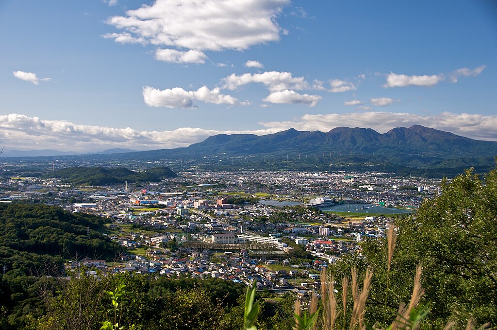
The sawtoothed caldera of Mount Akagi in late summer, rising from the rolling countryside with Kiryu City in the foreground.
355:
185:
516:
927:
795:
768:
724:
688:
565:
537:
524:
509:
399:
654:
601:
482:
465:
1242:
311:
1330:
If the file has been modified from its original state, some details may not fully reflect the modified file.
1192:
544:
65:
61:
57:
53:
47:
890:
The following pages on the
English Knowledge (XXG) use this file (pages on other projects are not listed):
110:
1472:
354:– If you remix, transform, or build upon the material, you must distribute your contributions under the
78:
1202:
917:
308:
761:"}},"text\/plain":{"en":{"P7787":"315 degree"}}}}": -->
1508:
1197:
173:
118:
877:
869:
1277:
1613:
1441:
1339:
381:
392:
Permission is granted to copy, distribute and/or modify this document under the terms of the
283:
Javbw, the copyright holder of this work, hereby publishes it under the following licenses:
1157:
1128:משתמש:WikiJunkie/רשימות שימושיות שמופקות באמצעות הבוט ליסטריה/הרי געש - כל הערכים שחסרים
1042:
162:
264:
181:
177:
158:
1576:
1490:
1356:
894:
105:
1623:
1586:
1396:
154:
248:
1222:
1177:
1167:
1542:
899:
858:
853:
69:
42:
997:
197:
1376:
1349:
1292:
962:
1633:
1366:
1212:
1187:
1162:
1022:
1077:
977:
937:
826:
Click on a date/time to view the file as it appeared at that time.
250:
1062:
225:
93:
1267:
235:
36° 22′ 42″ N, 139° 19′ 34″ E
1137:
1072:
1297:
1107:
1047:
1307:
1262:
1252:
1147:
1117:
1097:
1087:
1052:
987:
967:
952:
947:
83:(2,152 × 1,426 pixels, file size: 1.24 MB, MIME type:
1067:
635:
Creative
Commons Attribution-ShareAlike 3.0 Unported
618:
398:, Version 1.2 or any later version published by the
137:
117:
Commons is a freely licensed media file repository.
1017:
1007:
1287:
1232:
1032:
365:https://creativecommons.org/licenses/by-sa/3.0
98:
371:Creative Commons Attribution-Share Alike 3.0
289:
8:
758:
331:– to copy, distribute and transmit the work
1332:
828:
445:
430:You may select the license of your choice.
910:The following other wikis use this file:
1641:
1631:
1621:
1611:
1603:
1595:
1584:
1574:
1566:
1558:
1550:
1540:
1532:
1524:
1516:
1506:
1498:
1488:
1480:
1470:
1462:
1454:
1446:
1436:
1428:
1420:
1412:
1404:
1393:
1385:
1374:
1364:
1354:
1344:
892:
782:
766:
738:
722:
702:
686:
668:
652:
632:
615:
599:
579:
563:
496:
480:
463:
460:
441:
434:
228:
257:View this and other nearby images on:
1334:
7:
410:http://www.gnu.org/copyleft/fdl.html
312:Attribution-Share Alike 3.0 Unported
817:
300:
295:
1325:
454:
448:
429:
286:
282:
167:
147:
130:
76:
1043:Anexo:Montañas y colinas de Japón
453:
1387:Date and time of data generation
769:coordinates of the point of view
439:
386:
385:
342:Under the following conditions:
307:This file is licensed under the
299:
294:
288:
263:
249:
241:
168:
97:
31:
21:
784:36°22'41.999"N, 139°19'34.000"E
436:
148:
14:
435:
416:GNU Free Documentation License
405:GNU Free Documentation License
395:GNU Free Documentation License
26:
1:
998:100 berühmte japanische Berge
705:original creation by uploader
36:
1534:DateTimeDigitized subseconds
510:object of statement has role
461:Items portrayed in this file
240:
1526:DateTimeOriginal subseconds
1464:Date and time of digitizing
1274:Usage on pnb.wikipedia.org
1239:Usage on mzn.wikipedia.org
1209:Usage on ja.wikivoyage.org
1104:Usage on fr.wikivoyage.org
1014:Usage on en.wikivoyage.org
1004:Usage on de.wikivoyage.org
959:Usage on ceb.wikipedia.org
924:Usage on arz.wikipedia.org
1663:
1597:Focal length in 35 mm film
1555:One-chip color area sensor
1304:Usage on ro.wikipedia.org
1284:Usage on pt.wikipedia.org
1259:Usage on pl.wikipedia.org
1249:Usage on no.wikipedia.org
1229:Usage on lt.wikipedia.org
1219:Usage on ko.wikipedia.org
1154:Usage on ja.wikipedia.org
1144:Usage on it.wikipedia.org
1134:Usage on id.wikipedia.org
1124:Usage on he.wikipedia.org
1114:Usage on gl.wikipedia.org
1094:Usage on fr.wikipedia.org
1084:Usage on fi.wikipedia.org
1078:Zerrenda:Lurreko sumendiak
1059:Usage on eu.wikipedia.org
1039:Usage on es.wikipedia.org
1029:Usage on eo.wikipedia.org
994:Usage on de.wikipedia.org
984:Usage on cs.wikipedia.org
974:Usage on ce.wikipedia.org
944:Usage on ca.wikipedia.org
934:Usage on bg.wikipedia.org
914:Usage on ar.wikipedia.org
356:same or compatible license
1448:File change date and time
818:
207:
16:
963:Kiryū (lungsod sa Hapon)
438:
400:Free Software Foundation
322:
104:This is a file from the
1560:Custom image processing
1495:Center weighted average
875:
854:08:20, 29 November 2009
213:
203:
196:
193:
165:City, from Mount Chausu
140:
108:. Information from its
1643:Subject distance range
1293:Usuário:DarwIn/Vulcões
269:36.378333; 139.326111
153:The southeast side of
111:description page there
46:Size of this preview:
1482:Maximum land aperture
1467:14:36, 9 October 2009
1451:14:36, 9 October 2009
1422:Horizontal resolution
1390:14:36, 9 October 2009
1023:Pokémon Tour of Japan
157:and the outskirts of
1581:Manual white balance
880:|Permission= |other_
70:2,152 × 1,426 pixels
1518:DateTime subseconds
1430:Vertical resolution
1336:Camera manufacturer
337:– to adapt the work
52:Other resolutions:
1605:Scene capture type
1513:Flash did not fire
1409:Color Filter Array
1063:Gunma (prefektura)
538:Wikimedia username
525:author name string
66:1,280 × 848 pixels
62:1,024 × 679 pixels
1650:
1649:
1459:Aperture priority
1406:Pixel composition
1361:1/125 sec (0.008)
1340:NIKON CORPORATION
1317:more global usage
1173:赤城神社 (前橋市富士見町赤城山)
906:Global file usage
883:
760:
602:copyright license
447:
427:
426:
274:
273:
223:
222:
126:
125:
106:Wikimedia Commons
32:Global file usage
1654:
1456:Exposure Program
1333:
866:
806:
805:
800:
566:copyright status
547:
542:
532:
529:
519:
514:
423:
420:
417:
414:
411:
389:
388:
382:
378:
375:
372:
369:
366:
358:as the original.
320:
309:Creative Commons
303:
302:
298:
297:
292:
291:
270:
267:
253:
252:
246:
245:
244:
238:
237:
226:
209:
199:
172:
152:
144:
138:
122:
101:
100:
94:
88:
86:
73:
58:640 × 424 pixels
54:320 × 212 pixels
48:800 × 530 pixels
1662:
1661:
1657:
1656:
1655:
1653:
1652:
1651:
1321:
904:
891:
884:
872:
864:
820:
819:
816:
815:
814:
813:
812:
811:
810:
809:
808:
807:
803:
801:
798:
789:
788:
787:
785:
775:
774:
773:
771:
752:
751:
750:
749:
748:
747:
746:
745:
743:
731:
730:
729:
727:
716:
715:
714:
713:
712:
711:
710:
709:
707:
695:
694:
693:
691:
680:
679:
678:
677:
676:
675:
674:
673:
671:
661:
660:
659:
657:
646:
645:
644:
643:
642:
641:
640:
639:
637:
626:
625:
624:
623:
622:
620:
608:
607:
606:
604:
593:
592:
591:
590:
589:
588:
587:
586:
584:
572:
571:
570:
568:
557:
556:
555:
554:
553:
552:
551:
550:
549:
548:
543:
540:
534:
533:
530:
527:
521:
520:
515:
512:
503:
502:
501:
499:
489:
488:
487:
485:
474:
473:
472:
471:
470:
468:
452:
451:
450:
433:
432:
431:
421:
418:
415:
412:
409:
380:
379:
376:
373:
370:
367:
364:
363:
321:
318:
315:
304:
285:
284:
279:
268:
242:
233:
232:
229:Camera location
224:
189:
166:
142:
135:
128:
127:
116:
115:
114:is shown below.
90:
84:
82:
75:
74:
51:
12:
11:
5:
1660:
1658:
1648:
1647:
1644:
1640:
1639:
1636:
1630:
1629:
1626:
1620:
1619:
1616:
1610:
1609:
1606:
1602:
1601:
1598:
1594:
1593:
1590:
1583:
1582:
1579:
1573:
1572:
1569:
1565:
1564:
1563:Normal process
1561:
1557:
1556:
1553:
1552:Sensing method
1549:
1548:
1545:
1539:
1538:
1535:
1531:
1530:
1527:
1523:
1522:
1519:
1515:
1514:
1511:
1505:
1504:
1501:
1497:
1496:
1493:
1487:
1486:
1483:
1479:
1478:
1475:
1469:
1468:
1465:
1461:
1460:
1457:
1453:
1452:
1449:
1445:
1444:
1439:
1435:
1434:
1431:
1427:
1426:
1423:
1419:
1418:
1415:
1411:
1410:
1407:
1403:
1402:
1399:
1392:
1391:
1388:
1384:
1383:
1380:
1373:
1372:
1369:
1363:
1362:
1359:
1353:
1352:
1347:
1343:
1342:
1337:
1324:
1319:of this file.
1313:
1312:
1311:
1310:
1302:
1301:
1300:
1295:
1290:
1282:
1281:
1280:
1272:
1271:
1270:
1268:Akagi (szczyt)
1265:
1257:
1256:
1255:
1247:
1246:
1245:
1237:
1236:
1235:
1227:
1226:
1225:
1217:
1216:
1215:
1207:
1206:
1205:
1200:
1195:
1190:
1185:
1183:赤城神社 (前橋市三夜沢町)
1180:
1175:
1170:
1165:
1160:
1152:
1151:
1150:
1142:
1141:
1140:
1132:
1131:
1130:
1122:
1121:
1120:
1112:
1111:
1110:
1102:
1101:
1100:
1092:
1091:
1090:
1082:
1081:
1080:
1075:
1070:
1065:
1057:
1056:
1055:
1050:
1045:
1037:
1036:
1035:
1027:
1026:
1025:
1020:
1012:
1011:
1010:
1002:
1001:
1000:
992:
991:
990:
982:
981:
980:
972:
971:
970:
965:
957:
956:
955:
950:
942:
941:
940:
932:
931:
930:
928:جبل مونت اكاجى
922:
921:
920:
908:
907:
903:
902:
897:
889:
888:
887:
882:
881:
874:
870:
867:
863:2,152 × 1,426
861:
856:
851:
847:
846:
843:
840:
837:
834:
831:
824:
823:
794:
793:
792:
791:
790:
786:
783:
781:
780:
779:
778:
777:
776:
772:
767:
765:
764:
763:
762:
756:
744:
739:
737:
736:
735:
734:
733:
732:
728:
723:
721:
720:
719:
718:
717:
708:
703:
701:
700:
699:
698:
697:
696:
692:
689:source of file
687:
685:
684:
683:
682:
681:
672:
670:9 October 2009
669:
667:
666:
665:
664:
663:
662:
658:
653:
651:
650:
649:
648:
647:
638:
633:
631:
630:
629:
628:
627:
621:
616:
614:
613:
612:
611:
610:
609:
605:
600:
598:
597:
596:
595:
594:
585:
580:
578:
577:
576:
575:
574:
573:
569:
564:
562:
561:
560:
559:
558:
536:
535:
523:
522:
508:
507:
506:
505:
504:
500:
497:
495:
494:
493:
492:
491:
490:
486:
481:
479:
478:
477:
476:
475:
469:
464:
462:
459:
458:
457:
456:
455:
444:
443:
440:
437:
428:
425:
424:
390:
362:
361:
360:
359:
349:
340:
339:
338:
332:
325:You are free:
316:
306:
305:
287:
281:
280:
278:
275:
272:
271:
261:
255:
230:
221:
220:
215:
211:
210:
205:
201:
200:
198:9 October 2009
195:
191:
190:
145:
143:MountAkagi.jpg
136:
134:
131:
129:
124:
123:
102:
92:
91:
45:
41:
40:
39:
34:
29:
24:
19:
13:
10:
9:
6:
4:
3:
2:
1659:
1645:
1642:
1637:
1635:
1632:
1627:
1625:
1622:
1617:
1615:
1612:
1607:
1604:
1599:
1596:
1591:
1588:
1585:
1580:
1578:
1577:White balance
1575:
1571:Auto exposure
1570:
1568:Exposure mode
1567:
1562:
1559:
1554:
1551:
1546:
1544:
1541:
1536:
1533:
1528:
1525:
1520:
1517:
1512:
1510:
1507:
1502:
1499:
1494:
1492:
1491:Metering mode
1489:
1484:
1481:
1476:
1474:
1473:Exposure bias
1471:
1466:
1463:
1458:
1455:
1450:
1447:
1443:
1440:
1438:Software used
1437:
1432:
1429:
1424:
1421:
1416:
1413:
1408:
1405:
1400:
1398:
1394:
1389:
1386:
1381:
1378:
1375:
1370:
1368:
1365:
1360:
1358:
1357:Exposure time
1355:
1351:
1348:
1345:
1341:
1338:
1335:
1331:
1328:
1322:
1320:
1318:
1309:
1306:
1305:
1303:
1299:
1296:
1294:
1291:
1289:
1286:
1285:
1283:
1279:
1276:
1275:
1273:
1269:
1266:
1264:
1261:
1260:
1258:
1254:
1251:
1250:
1248:
1244:
1241:
1240:
1238:
1234:
1231:
1230:
1228:
1224:
1221:
1220:
1218:
1214:
1211:
1210:
1208:
1204:
1201:
1199:
1196:
1194:
1191:
1189:
1186:
1184:
1181:
1179:
1176:
1174:
1171:
1169:
1166:
1164:
1161:
1159:
1156:
1155:
1153:
1149:
1146:
1145:
1143:
1139:
1136:
1135:
1133:
1129:
1126:
1125:
1123:
1119:
1116:
1115:
1113:
1109:
1106:
1105:
1103:
1099:
1096:
1095:
1093:
1089:
1086:
1085:
1083:
1079:
1076:
1074:
1071:
1069:
1066:
1064:
1061:
1060:
1058:
1054:
1051:
1049:
1046:
1044:
1041:
1040:
1038:
1034:
1031:
1030:
1028:
1024:
1021:
1019:
1016:
1015:
1013:
1009:
1006:
1005:
1003:
999:
996:
995:
993:
989:
986:
985:
983:
979:
976:
975:
973:
969:
966:
964:
961:
960:
958:
954:
951:
949:
946:
945:
943:
939:
936:
935:
933:
929:
926:
925:
923:
919:
916:
915:
913:
912:
911:
905:
901:
898:
896:
895:Midori, Gunma
893:
885:
879:
873:
868:
862:
860:
857:
855:
852:
849:
848:
844:
841:
838:
835:
832:
830:
829:
827:
821:
797:
770:
742:
726:
725:captured with
706:
690:
656:
636:
619:
603:
583:
567:
546:
539:
526:
518:
511:
484:
467:
407:
406:
401:
397:
396:
391:
384:
383:
368:CC BY-SA 3.0
357:
353:
350:
347:
344:
343:
341:
336:
333:
330:
327:
326:
324:
323:
317:Attribution:
313:
310:
293:
276:
266:
262:
260:
259:OpenStreetMap
256:
254:
236:
231:
227:
219:
216:
212:
206:
202:
192:
187:
183:
179:
175:
171:
164:
160:
156:
151:
146:
139:
132:
120:
113:
112:
107:
103:
96:
95:
89:
80:
79:Original file
71:
67:
63:
59:
55:
49:
44:
38:
35:
33:
30:
28:
25:
23:
20:
18:
15:
1587:Digital zoom
1503:Fine weather
1500:Light source
1485:4 APEX (f/4)
1397:focal length
1346:Camera model
1329:
1326:
1314:
1243:کیریو، گونما
1138:Gunung Akagi
1073:Akagi mendia
918:كيرو (غونما)
909:
825:
822:File history
517:photographer
403:
393:
351:
345:
334:
328:
239:
169:
149:
119:You can help
109:
77:
22:File history
1543:Color space
1414:Orientation
1298:Monte Akagi
1048:Monte Akagi
900:Mount Akagi
582:copyrighted
352:share alike
346:attribution
155:Mount Akagi
141:Description
1624:Saturation
1350:NIKON D300
953:Mont Akagi
886:File usage
839:Dimensions
741:Nikon D300
498:some value
85:image/jpeg
27:File usage
1634:Sharpness
1442:Ver.1.00
1377:ISO speed
1278:ٹلہ اکاگی
1203:茶臼山 (桐生市)
968:Akagi San
865:(1.24 MB)
836:Thumbnail
833:Date/Time
655:inception
277:Licensing
150:English:
1614:Contrast
1608:Standard
1367:F-number
1323:Metadata
1068:Maebashi
442:Captions
335:to remix
329:to share
314:license.
208:Own work
37:Metadata
1646:Unknown
1193:新・花の百名山
850:current
845:Comment
796:heading
755:heading
483:creator
466:depicts
446:English
180:の街並。後ろは
133:Summary
81:
1638:Normal
1628:Normal
1618:Normal
1433:72 dpi
1425:72 dpi
1417:Normal
1379:rating
1198:二宮赤城神社
804:degree
759:degree
247:
214:Author
204:Source
163:Midori
1600:43 mm
1589:ratio
1509:Flash
1401:29 mm
1395:Lens
1315:View
1308:Kiryū
1288:Kiryu
1263:Kiryū
1253:Kiryū
1233:Kiriu
1158:日本百名山
1148:Kiryū
1118:Kiryū
1108:Kiryū
1098:Kiryū
1088:Kiryū
1053:Kiryū
1033:Kirju
1018:Gunma
1008:Gunma
988:Kirjú
948:Kiryū
878:Javbw
871:Javbw
545:Javbw
531:Javbw
319:Javbw
218:Javbw
188:から撮影。
159:Kiryu
1547:sRGB
1223:아카기산
1178:赤城神社
1168:上毛三山
978:Кирю
938:Кирю
842:User
802:315
422:true
419:true
413:GFDL
377:true
374:true
194:Date
174:みどり市
170:日本語:
161:and
17:File
1382:200
1371:f/4
1213:群馬県
1188:群馬県
1163:赤城山
186:茶臼山
182:赤城山
178:桐生市
1537:34
1529:34
1521:34
799::
541::
528::
513::
68:|
64:|
60:|
56:|
50:.
1592:1
1477:0
408:.
184:。
176:と
121:.
87:)
72:.
Text is available under the Creative Commons Attribution-ShareAlike License. Additional terms may apply.
