502:
394:
231:
43:
223:
347:
245:
508:
400:
99:
405:
820:"}},"text\/plain":{"en":{"":"heading"}}},"{\"value\":{\"amount\":\"+0\",\"unit\":\"http:\\\/\\\/www.wikidata.org\\\/entity\\\/Q28390\"},\"type\":\"quantity\"}":{"text\/html":{"en":{"P7787":"0
816:
952:
922:
214:
549:– You must give appropriate credit, provide a link to the license, and indicate if changes were made. You may do so in any reasonable manner, but not in any way that suggests the licensor endorses you or your use.
453:– You must give appropriate credit, provide a link to the license, and indicate if changes were made. You may do so in any reasonable manner, but not in any way that suggests the licensor endorses you or your use.
169:
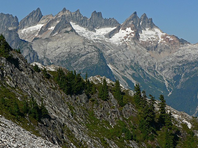
Mount Terror (left skyline), Mount
Degenhardt (left center skyline) with Pinnacle Peak in front, The Pyramid, Inspiration Peak (center), McMillan Spires (right center); Subalpine Fir and Mountain Hemlock
1139:
817:
364:
1189:
1412:
362:; with no Invariant Sections, no Front-Cover Texts, and no Back-Cover Texts. A copy of the license is included in the section entitled
354:
1064:
65:
61:
57:
53:
47:
1194:
110:
767:
731:
714:
697:
661:
238:
78:
803:
625:
1443:
1232:
This file contains additional information, probably added from the digital camera or scanner used to create or digitize it.
460:
1036:
1003:
Mount Terror (left), Pinnacle Peak, The
Pyramid, Inspiration Peak, McMillan Spires (right)}} |Source = Own work |Date =
858:
831:
787:
751:
645:
359:
1046:
681:
609:
981:
976:
951:
946:
414:
270:
1235:
If the file has been modified from its original state, some details may not fully reflect the modified file.
258:
1017:
The following pages on the
English Knowledge (XXG) use this file (pages on other projects are not listed):
1509:
518:
459:– If you remix, transform, or build upon the material, you must distribute your contributions under the
197:
999:== Summary == '''Mount Degenhardt''' {{Information |Description = {{en|
515:
411:
1545:
824:"}},"text\/plain":{"en":{"P7787":"0 degree"}}}}": -->
118:
1658:
341:
1159:
1084:
474:
352:
Permission is granted to copy, distribute and/or modify this document under the terms of the
1026:
1000:
921:
916:
69:
42:
1031:
1021:
992:
962:
932:
244:
159:
1613:
1527:
1491:
1261:
939:
Adobe
Photoshop Elements 11.0; 20% Auto Smart Fix, Adjust Lighting/Shadows/Highlights
338:
I, the copyright holder of this work, hereby publish it under the following licenses:
153:
105:
1668:
1623:
1301:
1041:
1563:
1094:
228:
1281:
1244:
1678:
1271:
1104:
1004:
1254:
279:
889:
Click on a date/time to view the file as it appeared at that time.
215:
48° 41′ 09.24″ N, 121° 19′ 15.24″ W
1149:
1129:
969:
Photoshop
Elements 4.0; autosmartfix, autocontrast, levels tools
230:
1119:
1074:
473:
This licensing tag was added to this file as part of the GFDL
388:
205:
93:
1179:
1169:
1079:
1109:
593:
Add a one-line explanation of what this file represents
1219:
1214:
1209:
83:(2,560 × 1,920 pixels, file size: 2.42 MB, MIME type:
1204:
732:
Creative
Commons Attribution-ShareAlike 3.0 Unported
698:
358:, Version 1.2 or any later version published by the
142:
117:
Commons is a freely licensed media file repository.
1550:Flash did not fire, compulsory flash suppression
1085:Terror Glacier (suba sa yelo sa Tinipong Bansa)
480:http://creativecommons.org/licenses/by-sa/3.0/
98:
501:
393:
8:
486:Creative Commons Attribution-Share Alike 3.0
821:
556:https://creativecommons.org/licenses/by/2.5
532:– to copy, distribute and transmit the work
436:– to copy, distribute and transmit the work
1237:
891:
589:
574:You may select the license of your choice.
1057:The following other wikis use this file:
715:Creative Commons Attribution 2.5 Generic
1702:
1694:
1686:
1676:
1666:
1656:
1648:
1640:
1632:
1621:
1611:
1603:
1595:
1587:
1579:
1571:
1561:
1553:
1543:
1535:
1525:
1517:
1507:
1499:
1489:
1481:
1460:
1452:
1441:
1433:
1425:
1417:
1413:Adobe Photoshop Elements 11.0 Macintosh
1407:
1399:
1391:
1383:
1375:
1367:
1349:
1341:
1333:
1325:
1317:
1309:
1298:
1290:
1279:
1269:
1259:
1249:
1019:
845:
829:
801:
785:
765:
749:
729:
712:
695:
679:
659:
643:
623:
607:
604:
585:
578:
208:
237:View this and other nearby images on:
1239:
269:Thornton Lakes, Trappers Peak Trail,
7:
415:Attribution-Share Alike 3.0 Unported
370:http://www.gnu.org/copyleft/fdl.html
880:
507:
404:
399:
1230:
598:
592:
573:
523:
498:
337:
179:14 September 2007, 15:00:28 −07:00
163:
130:
76:
597:
562:Creative Commons Attribution 2.5
1707:B80ECE273628161555D29B638458F71B
1330:1,719.021 meters above sea level
1292:Date and time of data generation
832:coordinates of the point of view
583:
543:Under the following conditions:
514:This file is licensed under the
506:
500:
447:Under the following conditions:
410:This file is licensed under the
403:
398:
392:
346:
345:
243:
229:
221:
97:
31:
21:
1696:Date metadata was last modified
580:
164:
14:
1704:Unique ID of original document
579:
376:GNU Free Documentation License
365:GNU Free Documentation License
355:GNU Free Documentation License
26:
1:
1592:A directly photographed image
768:original creation by uploader
36:
1160:North Cascades-þjóðgarðurinn
1140:הפארק הלאומי צפון רכס קסקייד
1037:North Cascades National Park
605:Items portrayed in this file
271:North Cascades National Park
1454:Date and time of digitizing
1176:Usage on lld.wikipedia.org
1071:Usage on ceb.wikipedia.org
1061:Usage on arz.wikipedia.org
1047:Terror Glacier (Washington)
1724:
1634:Focal length in 35 mm film
1576:One-chip color area sensor
1555:Supported Flashpix version
1201:Usage on www.wikidata.org
1186:Usage on ur.wikipedia.org
1166:Usage on it.wikipedia.org
1156:Usage on is.wikipedia.org
1146:Usage on hu.wikipedia.org
1136:Usage on he.wikipedia.org
1126:Usage on fr.wikipedia.org
1116:Usage on es.wikipedia.org
1101:Usage on de.wikipedia.org
1091:Usage on cs.wikipedia.org
847:48°41'9.2"N, 121°19'15.2"W
461:same or compatible license
316:Focal Length In 35mm Film:
220:
148:Mount Degenhardt 26001.JPG
1462:Meaning of each component
1419:File change date and time
881:
419:
391:
187:
16:
1457:15:00, 14 September 2007
1295:15:00, 14 September 2007
1005:2007:09:14T15:00:28-7.00
977:15:54, 22 September 2007
582:
360:Free Software Foundation
104:This is a file from the
1597:Custom image processing
1105:Nördliche Kaskadenkette
998:
968:
938:
804:Panasonic Lumix DMC-FZ5
519:Attribution 2.5 Generic
193:
183:
178:
175:
145:
108:. Information from its
1483:Image compression mode
1266:1/1,600 sec (0.000625)
947:04:00, 6 November 2009
328:©2007 Walter Siegmund
249:48.685900; -121.320900
111:description page there
46:Size of this preview:
1519:Maximum land aperture
1393:Horizontal resolution
1190:ٹیرر گلیشیر (واشنگٹن)
1584:Digital still camera
1385:Number of components
276:Viewpoint elevation:
70:2,560 × 1,920 pixels
1699:04:29, 21 July 2013
1427:Y and C positioning
1422:11:29, 21 July 2013
1401:Vertical resolution
1241:Camera manufacturer
917:18:37, 21 July 2013
538:– to adapt the work
442:– to adapt the work
267:Viewpoint location:
52:Other resolutions:
1642:Scene capture type
1618:Auto white balance
1351:Bits per component
1120:Cascadas del Norte
66:1,280 × 960 pixels
62:1,024 × 768 pixels
1711:
1710:
1369:Pixel composition
1322:121° 19′ 15.41″ W
1053:Global file usage
1010:
823:
682:copyright license
591:
497:
496:
387:
386:
322:ISO Speed Rating:
294:Panasonic DMC-FZ5
254:
253:
203:
202:
160:Tsuga mertensiana
126:
125:
106:Wikimedia Commons
32:Global file usage
1715:
1435:Exposure Program
1238:
1075:Mount Degenhardt
1065:جبل مكميلان سپير
1027:Mount Degenhardt
1001:Mount Degenhardt
989:
959:
929:
869:
868:
863:
646:copyright status
569:
566:
563:
560:
557:
516:Creative Commons
510:
509:
504:
503:
493:
490:
487:
484:
481:
478:
475:licensing update
463:as the original.
412:Creative Commons
407:
406:
402:
401:
396:
395:
389:
383:
380:
377:
374:
371:
349:
348:
342:
250:
247:
233:
232:
226:
225:
224:
218:
217:
206:
189:
168:
154:Abies lasiocarpa
149:
143:
138:Mount Degenhardt
122:
101:
100:
94:
88:
86:
73:
58:640 × 480 pixels
54:320 × 240 pixels
48:800 × 600 pixels
1723:
1722:
1718:
1717:
1716:
1714:
1713:
1712:
1688:GPS tag version
1522:3 APEX (f/2.83)
1314:48° 41′ 9.22″ N
1226:
1195:ماؤنٹ ڈیگینہارڈ
1095:Plaňkové pohoří
1051:
1018:
1011:
995:
987:
965:
957:
935:
927:
883:
882:
879:
878:
877:
876:
875:
874:
873:
872:
871:
870:
866:
864:
861:
852:
851:
850:
848:
838:
837:
836:
834:
815:
814:
813:
812:
811:
810:
809:
808:
806:
794:
793:
792:
790:
779:
778:
777:
776:
775:
774:
773:
772:
770:
758:
757:
756:
754:
743:
742:
741:
740:
739:
738:
737:
736:
734:
723:
722:
721:
720:
719:
717:
706:
705:
704:
703:
702:
700:
688:
687:
686:
684:
673:
672:
671:
670:
669:
668:
667:
666:
664:
652:
651:
650:
648:
637:
636:
635:
634:
633:
632:
631:
630:
628:
616:
615:
614:
612:
596:
595:
594:
577:
576:
575:
571:
570:
567:
564:
561:
558:
555:
554:
522:
511:
491:
488:
485:
482:
479:
472:
381:
378:
375:
372:
369:
340:
339:
334:
286:View direction:
248:
222:
213:
212:
209:Camera location
204:
198:Walter Siegmund
171:
147:
135:
128:
127:
116:
115:
114:is shown below.
90:
84:
82:
75:
74:
51:
12:
11:
5:
1721:
1719:
1709:
1708:
1705:
1701:
1700:
1697:
1693:
1692:
1689:
1685:
1684:
1681:
1675:
1674:
1671:
1665:
1664:
1661:
1655:
1654:
1651:
1647:
1646:
1643:
1639:
1638:
1635:
1631:
1630:
1627:
1620:
1619:
1616:
1610:
1609:
1606:
1602:
1601:
1600:Normal process
1598:
1594:
1593:
1590:
1586:
1585:
1582:
1578:
1577:
1574:
1573:Sensing method
1570:
1569:
1566:
1560:
1559:
1556:
1552:
1551:
1548:
1542:
1541:
1538:
1534:
1533:
1530:
1524:
1523:
1520:
1516:
1515:
1512:
1506:
1505:
1502:
1498:
1497:
1494:
1488:
1487:
1484:
1480:
1479:
1478:
1477:
1476:does not exist
1474:
1471:
1468:
1463:
1459:
1458:
1455:
1451:
1450:
1447:
1440:
1439:
1438:Normal program
1436:
1432:
1431:
1428:
1424:
1423:
1420:
1416:
1415:
1410:
1406:
1405:
1402:
1398:
1397:
1394:
1390:
1389:
1386:
1382:
1381:
1378:
1374:
1373:
1370:
1366:
1365:
1364:
1363:
1360:
1357:
1352:
1348:
1347:
1344:
1340:
1339:
1336:
1332:
1331:
1328:
1324:
1323:
1320:
1316:
1315:
1312:
1308:
1307:
1304:
1297:
1296:
1293:
1289:
1288:
1285:
1278:
1277:
1274:
1268:
1267:
1264:
1258:
1257:
1252:
1248:
1247:
1242:
1229:
1225:
1224:
1223:
1222:
1217:
1212:
1207:
1199:
1198:
1197:
1192:
1184:
1183:
1182:
1180:McMillan Spire
1174:
1173:
1172:
1170:North Cascades
1164:
1163:
1162:
1154:
1153:
1152:
1150:Picket-hegység
1144:
1143:
1142:
1134:
1133:
1132:
1130:Chaînon Picket
1124:
1123:
1122:
1114:
1113:
1112:
1107:
1099:
1098:
1097:
1089:
1088:
1087:
1082:
1077:
1069:
1068:
1067:
1055:
1054:
1050:
1049:
1044:
1039:
1034:
1032:North Cascades
1029:
1024:
1022:McMillan Spire
1016:
1015:
1014:
1009:
1008:
997:
993:
990:
986:2,560 × 1,920
984:
979:
974:
971:
970:
967:
963:
960:
956:2,560 × 1,920
954:
949:
944:
941:
940:
937:
933:
930:
926:2,560 × 1,920
924:
919:
914:
910:
909:
906:
903:
900:
897:
894:
887:
886:
857:
856:
855:
854:
853:
849:
846:
844:
843:
842:
841:
840:
839:
835:
830:
828:
827:
826:
825:
819:
807:
802:
800:
799:
798:
797:
796:
795:
791:
786:
784:
783:
782:
781:
780:
771:
766:
764:
763:
762:
761:
760:
759:
755:
752:source of file
750:
748:
747:
746:
745:
744:
735:
730:
728:
727:
726:
725:
724:
718:
713:
711:
710:
709:
708:
707:
701:
696:
694:
693:
692:
691:
690:
689:
685:
680:
678:
677:
676:
675:
674:
665:
660:
658:
657:
656:
655:
654:
653:
649:
644:
642:
641:
640:
639:
638:
629:
626:subalpine zone
624:
622:
621:
620:
619:
618:
617:
613:
608:
606:
603:
602:
601:
600:
599:
588:
587:
584:
581:
572:
553:
552:
551:
550:
541:
540:
539:
533:
526:You are free:
513:
512:
499:
495:
494:
469:
468:
467:
466:
465:
464:
454:
445:
444:
443:
437:
430:You are free:
425:
424:
421:
420:
418:
408:
385:
384:
350:
336:
335:
333:
330:
326:
325:
319:
313:
307:
301:
298:Exposure Time:
295:
289:
283:
273:
264:
259:Location Datum
252:
251:
241:
235:
210:
201:
200:
195:
191:
190:
185:
181:
180:
177:
173:
172:
150:
141:
134:
131:
129:
124:
123:
102:
92:
91:
45:
41:
40:
39:
34:
29:
24:
19:
13:
10:
9:
6:
4:
3:
2:
1720:
1706:
1703:
1698:
1695:
1690:
1687:
1682:
1680:
1677:
1672:
1670:
1667:
1662:
1660:
1657:
1652:
1650:Scene control
1649:
1644:
1641:
1636:
1633:
1628:
1625:
1622:
1617:
1615:
1614:White balance
1612:
1608:Auto exposure
1607:
1605:Exposure mode
1604:
1599:
1596:
1591:
1588:
1583:
1580:
1575:
1572:
1567:
1565:
1562:
1557:
1554:
1549:
1547:
1544:
1539:
1536:
1531:
1529:
1528:Metering mode
1526:
1521:
1518:
1513:
1511:
1510:Exposure bias
1508:
1503:
1501:APEX aperture
1500:
1495:
1493:
1492:Shutter speed
1490:
1485:
1482:
1475:
1472:
1469:
1466:
1465:
1464:
1461:
1456:
1453:
1448:
1445:
1442:
1437:
1434:
1429:
1426:
1421:
1418:
1414:
1411:
1409:Software used
1408:
1403:
1400:
1395:
1392:
1387:
1384:
1379:
1376:
1371:
1368:
1361:
1358:
1355:
1354:
1353:
1350:
1345:
1342:
1337:
1334:
1329:
1326:
1321:
1318:
1313:
1310:
1305:
1303:
1299:
1294:
1291:
1286:
1283:
1280:
1275:
1273:
1270:
1265:
1263:
1262:Exposure time
1260:
1256:
1253:
1250:
1246:
1243:
1240:
1236:
1233:
1227:
1221:
1218:
1216:
1213:
1211:
1208:
1206:
1203:
1202:
1200:
1196:
1193:
1191:
1188:
1187:
1185:
1181:
1178:
1177:
1175:
1171:
1168:
1167:
1165:
1161:
1158:
1157:
1155:
1151:
1148:
1147:
1145:
1141:
1138:
1137:
1135:
1131:
1128:
1127:
1125:
1121:
1118:
1117:
1115:
1111:
1108:
1106:
1103:
1102:
1100:
1096:
1093:
1092:
1090:
1086:
1083:
1081:
1078:
1076:
1073:
1072:
1070:
1066:
1063:
1062:
1060:
1059:
1058:
1052:
1048:
1045:
1043:
1040:
1038:
1035:
1033:
1030:
1028:
1025:
1023:
1020:
1012:
1006:
1002:
996:
991:
985:
983:
980:
978:
975:
973:
972:
966:
961:
955:
953:
950:
948:
945:
943:
942:
936:
931:
925:
923:
920:
918:
915:
912:
911:
907:
904:
901:
898:
895:
893:
892:
890:
884:
860:
833:
805:
789:
788:captured with
769:
753:
733:
716:
699:
683:
663:
647:
627:
611:
548:
545:
544:
542:
537:
534:
531:
528:
527:
525:
524:
520:
517:
505:
476:
471:
470:
462:
458:
455:
452:
449:
448:
446:
441:
438:
435:
432:
431:
429:
428:
427:
426:
423:
422:
416:
413:
409:
397:
390:
367:
366:
361:
357:
356:
351:
344:
343:
331:
329:
323:
320:
317:
314:
311:
310:Focal Length:
308:
305:
302:
299:
296:
293:
290:
287:
284:
281:
277:
274:
272:
268:
265:
262:
260:
256:
255:
246:
242:
240:
239:OpenStreetMap
236:
234:
216:
211:
207:
199:
196:
192:
186:
182:
174:
167:
162:
161:
156:
155:
151:
144:
140:
139:
132:
120:
113:
112:
107:
103:
96:
95:
89:
80:
79:Original file
71:
67:
63:
59:
55:
49:
44:
38:
35:
33:
30:
28:
25:
23:
20:
18:
15:
1624:Digital zoom
1537:Light source
1302:focal length
1251:Camera model
1234:
1231:
1110:Picket Range
1080:Picket Range
1056:
1042:Picket Range
888:
885:File history
546:
535:
529:
483:CC BY-SA 3.0
456:
450:
439:
433:
363:
353:
327:
321:
315:
309:
303:
297:
291:
285:
275:
266:
257:
219:
170:(foreground)
165:
158:
152:
137:
136:
119:You can help
109:
77:
22:File history
1581:File source
1564:Color space
1377:Orientation
662:copyrighted
547:attribution
457:share alike
451:attribution
146:Description
1669:Saturation
1589:Scene type
1013:File usage
902:Dimensions
559:CC BY 2.5
85:image/jpeg
27:File usage
1679:Sharpness
1496:10.643856
1319:Longitude
1282:ISO speed
1245:Panasonic
1220:Q14713922
1215:Q14713830
1210:Q14713812
994:Wsiegmund
988:(1.89 MB)
964:Wsiegmund
958:(1.42 MB)
934:Wsiegmund
928:(2.42 MB)
899:Thumbnail
896:Date/Time
417:license.
332:Licensing
304:F Number:
282:(5640 ft)
166:English:
1659:Contrast
1645:Standard
1504:4.970854
1430:Co-sited
1346:1,920 px
1338:2,560 px
1327:Altitude
1311:Latitude
1272:F-number
1228:Metadata
1205:Q2961865
586:Captions
536:to remix
530:to share
521:license.
440:to remix
434:to share
188:Own work
37:Metadata
1691:0.0.2.2
1540:Unknown
1446:version
1306:18.6 mm
1255:DMC-FZ5
913:current
908:Comment
859:heading
818:heading
610:depicts
590:English
292:Camera:
133:Summary
81:
1683:Normal
1673:Normal
1663:Normal
1637:112 mm
1404:72 dpi
1396:72 dpi
1380:Normal
1343:Height
1284:rating
867:degree
822:degree
300:1/1600
227:
194:Author
184:Source
1626:ratio
1546:Flash
1514:−0.66
1335:Width
1300:Lens
1276:f/5.6
306:f/5.6
288:North
280:meter
278:1719
263:WGS84
1653:None
1568:sRGB
1532:Spot
1444:Exif
905:User
568:true
565:true
492:true
489:true
382:true
379:true
373:GFDL
312:18.6
176:Date
17:File
1449:2.2
1372:RGB
318:112
1473:Cr
1470:Cb
1287:80
865:0
862::
324:80
157:,
68:|
64:|
60:|
56:|
50:.
1629:0
1558:1
1486:4
1467:Y
1388:3
1362:8
1359:8
1356:8
1007:|
477:.
368:.
261::
121:.
87:)
72:.
Text is available under the Creative Commons Attribution-ShareAlike License. Additional terms may apply.
