162:
168:
173:
67:
520:
214:– You must give appropriate credit, provide a link to the license, and indicate if changes were made. You may do so in any reasonable manner, but not in any way that suggests the licensor endorses you or your use.
38:
816:
583:
631:
588:
431:
395:
221:
379:
351:
336:
323:
451:
415:
296:
279:
78:
46:
358:
183:
559:
The following pages on the
English Knowledge (XXG) use this file (pages on other projects are not listed):
573:
220:– If you remix, transform, or build upon the material, you must distribute your contributions under the
180:
603:
86:
731:
343:
831:
568:
621:
593:
563:
111:
73:
519:
514:
155:
I, the copyright holder of this work, hereby publish it under the following license:
37:
598:
578:
546:
538:
530:
706:
711:
122:
144:
751:
661:
666:
721:
681:
826:
766:
549:}} {{self|cc-by-sa-2.5}} [[Category:Maps of rivers of the United
487:
Click on a date/time to view the file as it appeared at that time.
133:
716:
701:
676:
542:
61:
786:
691:
656:
671:
651:
761:
646:
641:
776:
263:
Add a one-line explanation of what this file represents
806:
801:
796:
100:
85:
Commons is a freely licensed media file repository.
741:
432:
Creative
Commons Attribution-ShareAlike 2.5 Generic
51:(500 × 500 pixels, file size: 106 KB, MIME type:
231:https://creativecommons.org/licenses/by-sa/2.5
66:
237:Creative Commons Attribution-Share Alike 2.5
161:
8:
197:– to copy, distribute and transmit the work
489:
344:https://commons.wikimedia.org/user:Kmusser
259:
614:The following other wikis use this file:
584:St. Joseph River (Maumee River tributary)
561:
541:watershed. |Source=Self-made, based on
465:
449:
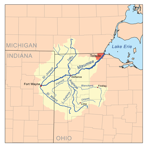
429:
413:
393:
377:
310:
294:
277:
274:
255:
248:
537:{{Information |Description=Map of the
7:
478:
184:Attribution-Share Alike 2.5 Generic
172:
167:
589:St. Marys River (Indiana and Ohio)
545:data. |Date=May 16, 2007 |Author=
268:
262:
158:
154:
98:
44:
267:
253:
208:Under the following conditions:
179:This file is licensed under the
171:
166:
160:
65:
31:
21:
752:Presidenza di George Washington
707:Présidence de George Washington
662:St. Joseph River (Maumee River)
250:
41:No higher resolution available.
14:
783:Usage on simple.wikipedia.org
667:St. Marys River (Maumee River)
249:
26:
1:
712:Rivière Sainte-Marie (Maumee)
682:Ottawa River (Auglaize River)
275:Items portrayed in this file
813:Usage on xmf.wikipedia.org
628:Usage on arz.wikipedia.org
850:
823:Usage on zh.wikipedia.org
793:Usage on www.wikidata.org
773:Usage on pt.wikipedia.org
767:St. Joseph (zlewisko Erie)
758:Usage on pl.wikipedia.org
748:Usage on it.wikipedia.org
738:Usage on hu.wikipedia.org
728:Usage on he.wikipedia.org
698:Usage on fr.wikipedia.org
688:Usage on es.wikipedia.org
638:Usage on de.wikipedia.org
618:Usage on ar.wikipedia.org
222:same or compatible license
479:
16:
722:Rivière Blanchard (Ohio)
252:
188:
72:This is a file from the
536:
140:
128:
121:
118:
103:
76:. Information from its
79:description page there
677:Little Auglaize River
574:Little Auglaize River
132:Self-made, based on
604:User:Kmusser/Images
203:– to adapt the work
515:16:36, 16 May 2007
352:Wikimedia username
324:author name string
106:Maumeerivermap.png
47:Maumeerivermap.png
632:نهر اوجليز الصغير
610:Global file usage
552:
416:copyright license
261:
150:
149:
94:
93:
74:Wikimedia Commons
32:Global file usage
841:
717:Rivière Auglaize
702:Maumee (rivière)
527:
380:copyright status
361:
356:
346:
341:
331:
328:
244:
241:
238:
235:
232:
224:as the original.
181:Creative Commons
175:
174:
170:
169:
164:
163:
124:
107:
101:
90:
69:
68:
62:
56:
54:
849:
848:
844:
843:
842:
840:
839:
838:
817:მომი (წყარმალუ)
657:Blanchard River
608:
569:Blanchard River
560:
553:
533:
525:
481:
480:
477:
476:
475:
474:
473:
472:
471:
470:
468:
458:
457:
456:
454:
443:
442:
441:
440:
439:
438:
437:
436:
434:
422:
421:
420:
418:
407:
406:
405:
404:
403:
402:
401:
400:
398:
386:
385:
384:
382:
371:
370:
369:
368:
367:
366:
365:
364:
363:
362:
357:
354:
348:
347:
342:
339:
333:
332:
329:
326:
317:
316:
315:
313:
303:
302:
301:
299:
288:
287:
286:
285:
284:
282:
266:
265:
264:
247:
246:
245:
242:
239:
236:
233:
230:
229:
187:
176:
157:
156:
151:
105:
96:
95:
84:
83:
82:is shown below.
58:
52:
50:
43:
42:
12:
11:
5:
847:
845:
837:
836:
835:
834:
829:
821:
820:
819:
811:
810:
809:
804:
799:
791:
790:
789:
781:
780:
779:
771:
770:
769:
764:
756:
755:
754:
746:
745:
744:
736:
735:
734:
726:
725:
724:
719:
714:
709:
704:
696:
695:
694:
686:
685:
684:
679:
674:
672:Flatrock Creek
669:
664:
659:
654:
652:Auglaize River
649:
644:
636:
635:
634:
626:
625:
624:
612:
611:
607:
606:
601:
596:
594:Stream capture
591:
586:
581:
576:
571:
566:
564:Auglaize River
558:
557:
556:
551:
550:
535:
531:
528:
522:
517:
512:
508:
507:
504:
501:
498:
495:
492:
485:
484:
469:
466:
464:
463:
462:
461:
460:
459:
455:
450:
448:
447:
446:
445:
444:
435:
430:
428:
427:
426:
425:
424:
423:
419:
414:
412:
411:
410:
409:
408:
399:
394:
392:
391:
390:
389:
388:
387:
383:
378:
376:
375:
374:
373:
372:
350:
349:
335:
334:
322:
321:
320:
319:
318:
314:
311:
309:
308:
307:
306:
305:
304:
300:
295:
293:
292:
291:
290:
289:
283:
278:
276:
273:
272:
271:
270:
269:
258:
257:
254:
251:
228:
227:
226:
225:
215:
206:
205:
204:
198:
191:You are free:
178:
177:
159:
153:
152:
148:
147:
142:
138:
137:
130:
126:
125:
120:
116:
115:
108:
99:
97:
92:
91:
70:
60:
59:
40:
36:
35:
34:
29:
24:
19:
13:
10:
9:
6:
4:
3:
2:
846:
833:
830:
828:
825:
824:
822:
818:
815:
814:
812:
808:
805:
803:
800:
798:
795:
794:
792:
788:
785:
784:
782:
778:
775:
774:
772:
768:
765:
763:
760:
759:
757:
753:
750:
749:
747:
743:
740:
739:
737:
733:
730:
729:
727:
723:
720:
718:
715:
713:
710:
708:
705:
703:
700:
699:
697:
693:
690:
689:
687:
683:
680:
678:
675:
673:
670:
668:
665:
663:
660:
658:
655:
653:
650:
648:
645:
643:
640:
639:
637:
633:
630:
629:
627:
623:
620:
619:
617:
616:
615:
609:
605:
602:
600:
597:
595:
592:
590:
587:
585:
582:
580:
577:
575:
572:
570:
567:
565:
562:
554:
548:
544:
540:
534:
529:
523:
521:
518:
516:
513:
510:
509:
505:
502:
499:
496:
493:
491:
490:
488:
482:
453:
433:
417:
397:
381:
360:
353:
345:
338:
325:
298:
281:
234:CC BY-SA 2.5
223:
219:
216:
213:
210:
209:
207:
202:
199:
196:
193:
192:
190:
189:
185:
182:
165:
146:
143:
139:
135:
131:
127:
117:
113:
109:
102:
88:
81:
80:
75:
71:
64:
63:
57:
48:
39:
33:
30:
28:
25:
23:
20:
18:
15:
787:Maumee River
762:Maumee River
647:Tiffin River
642:Maumee River
613:
599:Tiffin River
579:Maumee River
539:Maumee River
486:
483:File history
217:
211:
200:
194:
112:Maumee River
87:You can help
77:
45:
22:File history
467:16 May 2007
396:copyrighted
218:share alike
212:attribution
123:16 May 2007
110:Map of the
104:Description
777:Rio Maumee
692:Río Maumee
555:File usage
524:500 × 500
500:Dimensions
312:some value
114:watershed.
27:File usage
732:כיבוש נהר
497:Thumbnail
494:Date/Time
452:inception
53:image/png
807:Q1865569
802:Q1713780
797:Q1427373
622:أسر نهري
526:(106 KB)
256:Captions
201:to remix
195:to share
186:license.
547:Kmusser
532:Kmusser
511:current
506:Comment
359:Kmusser
330:Kmusser
297:creator
280:depicts
260:English
145:Kmusser
49:
742:Maumee
141:Author
129:Source
832:奥格莱兹河
136:data.
543:USGS
503:User
243:true
240:true
134:USGS
119:Date
17:File
827:莫米河
337:URL
355::
340::
327::
89:.
55:)
Text is available under the Creative Commons Attribution-ShareAlike License. Additional terms may apply.